(5:10 PM CT Update): Beryl continues to defy some logic and fight back hard against wind shear. Satellite presentation has improved a good bit over the last couple hours, and it’s tracking very close to the coast of Jamaica.

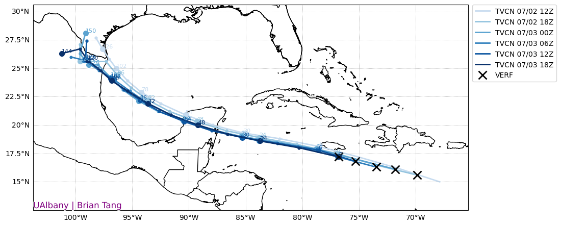
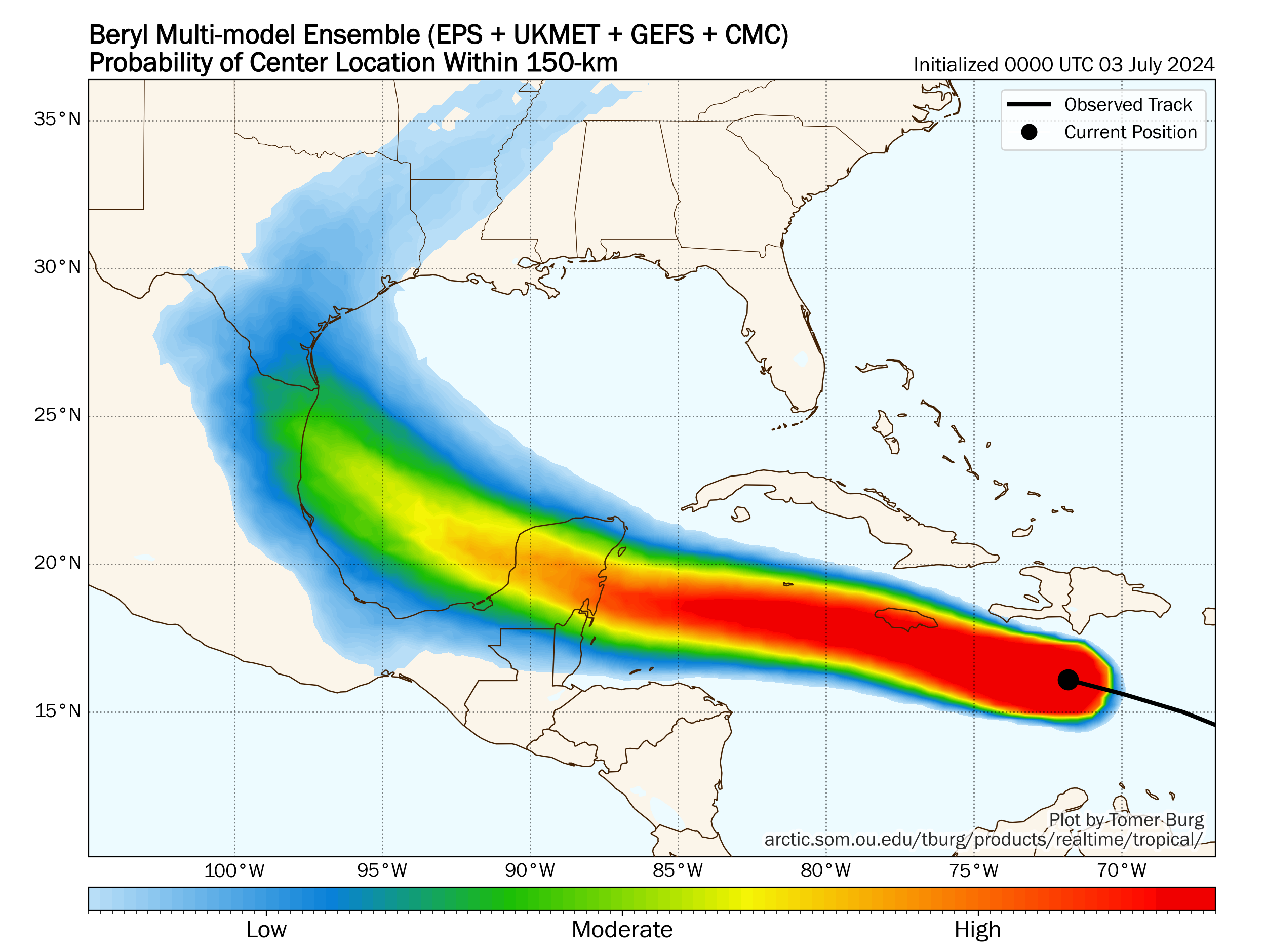
Land interaction and continued wind shear should allow Beryl to weaken a bit more as it passes off to the west tonight. In general though, while Beryl’s central pressure has been gradually increasing, its winds seem to want to keep going. Model guidance did a couple things today with respect to Beryl going forward. There are no meaningful changes to track or impacts for the Yucatan, with a landfall near Tulum expected on Friday. Beyond the Yucatan, the models again adjusted back south (after a flirtation back north after our post this morning). Most European ensemble members and most tropical models favor a track south of South Padre Island, TX.
At this point, I would say that folks from Corpus Christi southward should continue to watch Beryl closely. North of there, we don’t currently expect any significant impacts at this time. Beryl is expected to weaken to a tropical storm over the Yucatan before restrengthening, albeit slowly, into a hurricane in the Bay of Campeche or southwest Gulf. More on this and the rainfall expected from Beryl for Texas as a whole tomorrow morning.
Headlines
- Beryl will make a close pass to Jamaica later today as a major hurricane with surge, wind, and heavy rainfall.
- Beryl is beginning to feel the effects of wind shear and slow, steady weakening is forecast as it comes west.
- It is still likely to be a hurricane as it approaches the Yucatan on Friday, likely coming ashore south of Cancun and Cozumel.
- Beryl should continue toward the northern Mexico or far south Texas coast as a tropical storm or lower-end hurricane this weekend.
- Heavy rainfall is likely in Mexico and far South Texas as Beryl comes ashore and begins to slow down.
Hurricane Beryl (145 mph, WNW 20 mph)
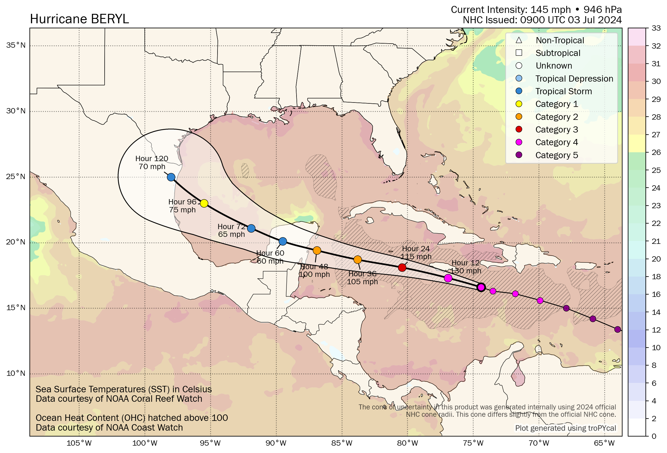
Hurricane Beryl was a resilient storm through much of yesterday, as its core managed to resist some of the shear Beryl began experiencing. Alas, Beryl’s satellite presentation has degraded markedly this morning, with even the eye becoming filled with clouds.
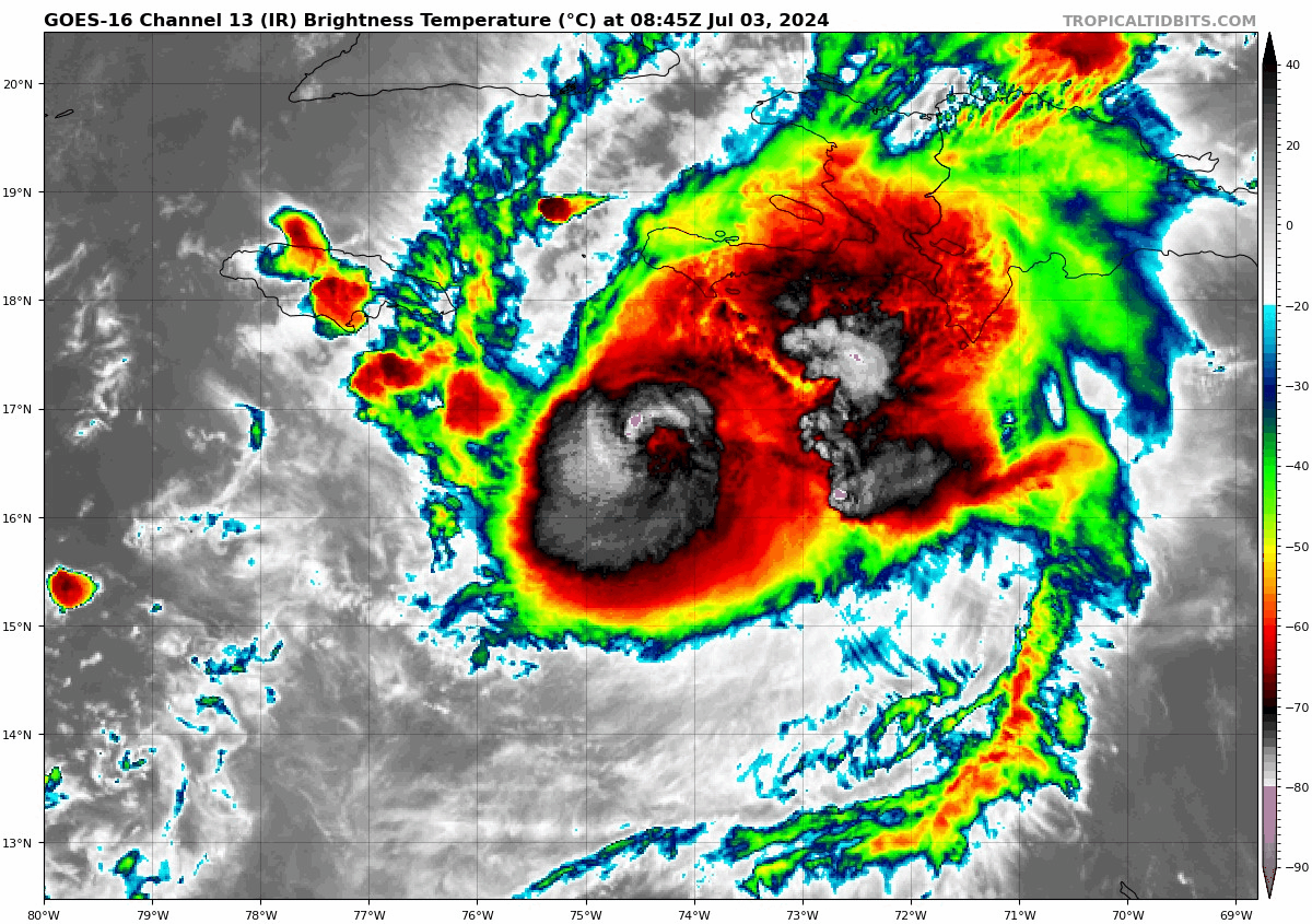
That said, its on a beeline for Jamaica as a major hurricane and conditions should begin to deteriorate through the day today. Significant surge and wind, in addition to heavy rainfall should arrive in Jamaica today and continue into tonight. Despite the satellite presentation degrading, that is still a nasty core of the hurricane heading to Jamaica. For the Cayman Islands, surge and wind, in addition to heavy rain arrive late tonight or tomorrow.

As Beryl comes west, it is expected to maintain hurricane intensity as it approaches the Yucatan this weekend. The current forecast likely keeps the center of the storm south of Cancun and Cozumel, with a landfall likely near or south of Tulum. In recent days, the debate within modeling has been surrounding its intensity. A stronger storm was more likely to lift northwest toward the Houston area or Louisiana, while a weaker storm would stay farther south into Mexico or extreme south Texas. We seem to be approaching a mild consensus right now on that track. There are still a very, very small number of outliers bringing Beryl north of Matagorda Bay late this weekend. However, the vast majority of ensemble members and tropical models are now in decent agreement in bringing Beryl more on the southern half of the forecast envelope.
For information specific to Houston, check out the latest at Space City Weather. But it would appear that this comes in well south of the Houston area. It will be important to check back again later today or tomorrow morning just to ensure that remains the case.
The Yucatan will do a number on Beryl, but there may be a brief window for Beryl to regain strong tropical storm or hurricane status as it comes across the Bay of Campeche before coming ashore.
One interesting wrinkle with Beryl, regardless of its intensity as it comes ashore in the western Gulf will be how fast it slams on the brakes. Beryl has been plowing west all week around 20 mph give or take. When it gets to the Gulf Coast, the strong high pressure that had been steering Beryl will begin to weaken some but not dissipate completely. Meanwhile, the West will be enduring a long-duration heat wave with strong high pressure over California.
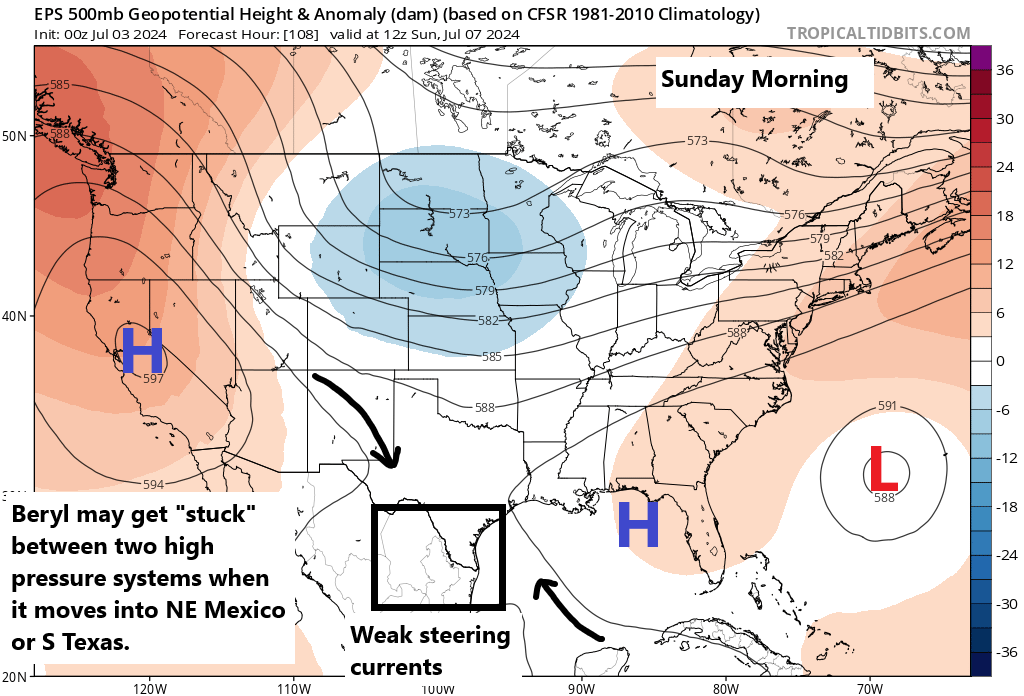
That could lead to steering currents weakening and forcing Beryl to slow down substantially or even stall out for a short time over Mexico or far South Texas. When the “s” word gets thrown around, I know some folks in Texas can panic, but I want to be clear. This isn’t a Harvey-redux. Even models that do show a stall keep rain totals far under that. That being said, this is a unique storm on its own and while rain would be extremely welcome in the Rio Grande and northern Mexico, too much rain can always cause issues. So we’ll watch trends in the coming days closely.
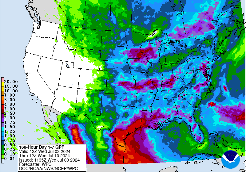
Rain should transition to scattered thunderstorms into next week over Texas and Mexico.
Invest 96L
Beryl’s much less talented sibling is Invest 96L, which continues to follow in Beryl’s footsteps. It has plenty of thunderstorms with it, but it is being blasted by what is basically the “exhaust” from Beryl, which is keeping it completely disorganized.

While this will unfortunately deliver heavy rain to some of the storm ravaged Windward Islands today, it is unlikely to develop much beyond this over the next two to three days. Most modeling keeps it this way until the bitter end. The usual troublemakers (the GFS and Canadian models) try to make something of it, but I think that’s a very low likelihood scenario. That said, if the thunderstorm activity can be maintained as it tracks into Mexico, it could add a shot in the arm to any rainfall ongoing in that region or far South Texas next week, a scenario that’s plausible. We’ll keep an eye on things.
Beyond 96L, the tropics are expected to shut down for a little bit. Here’s hoping that’s the case.
Thanks for the hard work on the updates!
I appreciate your non-dramatic super clear coverage! At a first year islander I’m taking in every detail. Thank you!
Katie
Galveston, TX
Thank you for the straightforward update. I was watching other weather and beginning to get very concerned as they continue to hype the possibility of a hook up to Houston. While I realize that’s still in the realm of possibility, my anxiety appreciates probabilities and likelihoods.
Stellar nuanced work as always. Thank you guys so much!
Came for the “no hype” but stayed for the *mirth.*
@Matt, you have a gift.
“Less talented sibling…”
“Exhaust from Beryl…”
“The usual troublemakers…”
Thank you!!
How does a storm affect water temperature?
It tends to temporarily cool them somewhat. In Beryl’s case, since it was moving so fast, it seems the impact was minimal, with just a modest cooling that will probably fade after a week or two.
So more storms will help to alleviate the current extreme of oceanic heat? Got it! So a big storm every ~10 days will help bring oceanic temperatures back down to normal! 🥴
Though I now live on the FL east coast, you guys are my reference standard! Thank for all you do, you are very much appreciated. God Bless!
Yes, as always, thank you from the Corpus Christi area for being the GO TO for clear useful info !
💓 Corpus 💓
I’m in Corpus and will watch this closely. Thanks for the site.
Seems like every time a new model gets released, Beryl’s cone gets moved further north (yesterday, for example, it was well south of Corpus, now it’s halfway from Corpus to Houston). Also seems like its strength keeps consistently over-performing, like how a few days ago, it was supposed to cap out at around a Cat 2. I understand not wanting to overhype, but there’s such a thing as over-dismissive too.