Thanks for bearing with us over the last couple days as your primary author took a few days up in Chicago for only marginally cooler weather than Houston and nearly found himself in an EF-0 tornado. We are back and rolling now.
Headlines
- A disturbance in the Caribbean has a 20 percent chance of development over the next week as it tracks toward Central America or the Yucatan.
- Another potential wave behind it is worth watching into next week, but Saharan dust may play a role in this one.
- Today’s post also gives you some other recommended reading during hurricane season.
Disturbances and dust
We are one named storm and a couple disturbances into what was expected to be a very, very active Atlantic hurricane season. So is it trending to a bust, as I’ve seen some rumblings of lately? It’s important to remember that June’s outcomes do not have any real significant bearing on what the rest of hurricane season will bring. By total accumulated cyclone energy (ACE), we are only 1.6 percent of the way through the season climatologically. So over 98 percent of the season awaits in terms of that metric. It’s a marathon.
We have one disturbance coming across the Caribbean with about a 20 percent chance of development over the next week or so.
Despite the look on satellite, weather modeling is not overeager about this disturbance’s future. It’s expected to basically maintain this track west-northwest toward Central America or the Yucatan, following in the general footsteps of Alberto and Invest 93L this past weekend. We’ll continue to monitor this one, but at this point it’s not expected to become a serious problem.
Elsewhere, we don’t currently expect development over the next week or so. Modeling is beginning to hint at an Atlantic disturbance sometime next week, but it’s far too early to speculate on potential development or down-the-road impacts.
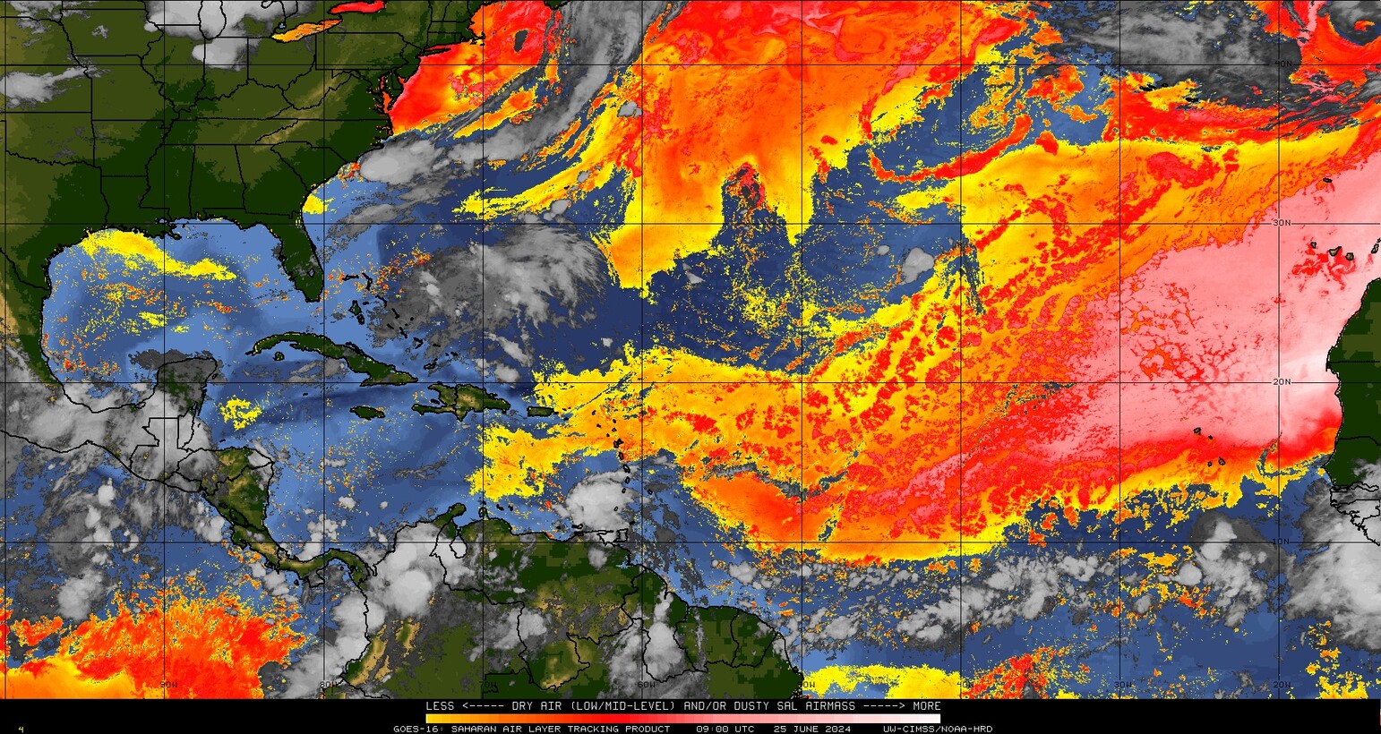
Meanwhile, we have a healthy blast of Saharan dust, not atypical for June spreading across the Atlantic. That may very well be a player in any potential development next week. Stay tuned.
Shopping around for other weather experts
One question I am often asked is “Who else do you recommend I follow?” We obviously want folks to follow us, but I strongly encourage people to have multiple sources to use for weather information. Find a few that fit your consumption habits best and lean on them.
In general, it’s a tough question. There are so many voices in the field of meteorology, particularly on social media that deserve to be elevated, and I try to do this where possible and include some of their work here when it’s topical. But today I just want to shout out a few who provide daily or relatively frequent tropical updates through the season that I feel are worth your time to read or subscribe to.
You may remember Michael Lowry from his time on The Weather Channel, but he currently works as the hurricane and storm surge expert for WPLG in South Florida. He also publishes a daily tropical update on Substack that you should subscribe to. He and I see eye to eye (pun intended) on a lot of weather communication topics, and he’s one of the best in the field at cutting through the noise and focusing on impacts, a critical need today.
Dr. Jeff Masters developed a beloved hurricane blog and audience at Weather Underground through much of the 2000s. He and Bob Henson have found their way over to Yale Climate Connections “Eye on the Storm” blog. For most hardcore weather enthusiasts, you know exactly what you’ll get from those two. For those new to them, just take my advice and follow them both. Two of the best to ever do it.
Another source you should consider following: Weather Tiger, also known as Dr. Ryan Truchelut. He earned his stripes at Florida State University and has been writing about tropical weather for a number of years, frequently cited in USA Today. He has a free and paid option on Substack, and you’ll find his work engaging, enlightening, and entertaining.
I recommend these three sources specifically because they’re easily accessible, good character people, they do phenomenal work, and they all have a lengthy history of publishing high quality, trustworthy content on weather, climate, and specifically the tropics.
I want to also be clear that I have obviously left some sources out and also that not every excellent communicative meteorologist or tropical expert is a prolific writer. In a future post, I want to also highlight some social media follows and those with websites that have data, posts, or imagery that may be of interest as well from the same caliber individuals as above. Look for that soon.
Nope, no need to shop around. Space City Weather and The Eyewall will always be my go to. Why? Number one reason, the weather without the hype. None of the local stations are reliable. I think everyone is sick and tired seeing storms in the Gulf and the locals want to create some sensationalism with a storm’s direction. Sure warn us, but give us the correct information so we can make good decisions. When they’re wrong, they just move on with no explanation. I can’t remember the last time I watched a local weather station for everyday weather or storm information.
Sure like Lowry
I would also recommend Larry Cosgrove. He’s on all the primary social media platforms (LinkedIn, Facebook, Twitter). Great explanations for how weather around the world can affect weather in the US.
Living on Tiki Island rain events are not usually a big deal and the wind is well covered. However it’s really hard to find good information on storm surge (inundation). Do you have a good source for that? It’s our biggest worry. At four feet we’ve got water over the bulkhead and half way up to the stairs.
It’s hard short of local media and the local NWS office. We try our best at SCW to tackle surge, but certainly in this most recent instance things overperformed. But the NWS in Houston has resources and info on that when the time comes. We’ll continue to do our best to share!