Headlines
- There are multiple areas to watch in the Atlantic, none of which is really a major concern in terms of development.
- The main place to watch is the Gulf of Mexico, where heavy rain in Louisiana today from a frontal low is causing localized flooding.
- The Caribbean wave may make a slight effort to develop next week in the western Gulf, but again, the primary concern will be rainfall in coastal Texas and Louisiana as that moisture lifts north and northeast.
- A return to more “average” basin conditions may unfold late in the month.
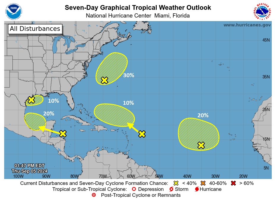
If you asked me in May to tell you what the NHC outlook map would look like on September 5th, I would have said that it would look something like the map above, though perhaps with more orange and red shaded regions and/or named storms. But, busy. If you asked me how many of those areas on that day would be of actual concern, I would have guessed about four. Instead, we got the map, but of the 5 outlined areas, maybe 0.5 is of actual concern — and not even really because it has a chance to develop.
The three Atlantic disturbances are honestly of no consequence. The one northwest of Bermuda (Invest 99L) is likely to track toward Atlantic Canada as a rain maker and gale heading toward the weekend. We’re looking at 20 to 60 mm of rainfall for Nova Scotia, PEI, and portions of eastern New Brunswick from this in addition to rough marine conditions.
The other two disturbances in the Atlantic are likely to stay out at sea and end up on the lower-end of the intensity scale as it stands right now.
Caribbean wave & Gulf of Mexico permalow: Mainly a rain concern
Flash flooding is ongoing in parts of Louisiana as heavy rain associated with a frontal low in the Gulf of Mexico expands north and east today.
Because this low tried to consolidate a bit this morning, the heaviest rain has occurred well offshore with close to 15 inches estimated in some cases.
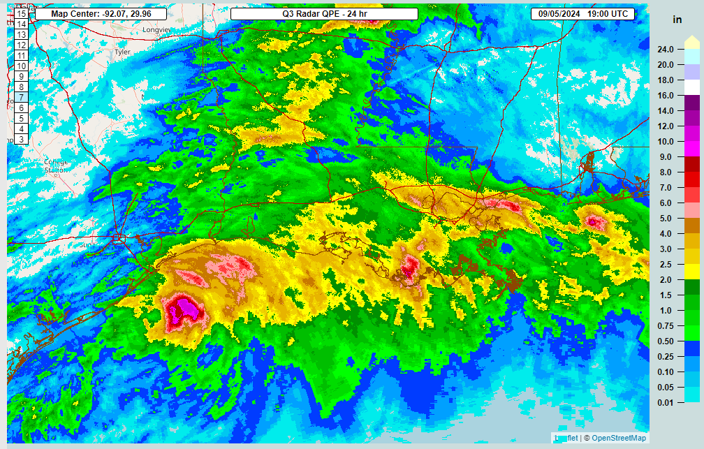
However, very heavy rain has occurred and is continuing in parts of eastern Louisiana and even southern Mississippi where upwards of 5 to 7 inches has occurred in spots, heaviest between I-10 and I-12 near Lake Pontchartrain and just east of New Orleans into Hancock County, Mississippi. This low will be sheared apart, with one piece heading eastward and another southward over the next 48 hours. The first Gulf Coast cold front of the season arrives in places like Houston and Lake Charles into Mississippi and Alabama this weekend. That will help clear the deck.
So then what? Well, this tropical wave that we’ve been discussing for days now finally makes it into the Bay of Campeche this weekend. It will sit and fester a bit, sort of merging together with the piece of the current system in the Gulf that will also fester down there. And you get another low pressure system. The Gulf is home to a permalow this month. Modeling goes two ways with this. The generally trustworthy European ensembles limit development risk of this area to maybe 40% for a depression and 30% or less for a tropical storm.
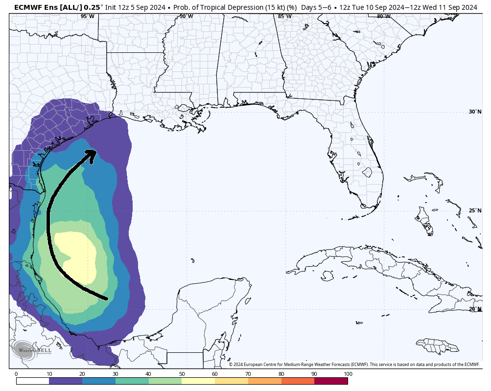
The storm track would probably be north and northeast toward Louisiana, and the ceiling on this would be low, probably below strong tropical storm intensity. However, more volatile models like the European AIFS (AI model) and ICON (German model) show this developing into a tropical storm, tracking toward Louisiana as well next Wednesday. In the former case, with no real development, we end up with a situation like we saw this week: Heavy rain at times near the coast midweek next week. But no organization. In the latter case with development, we get a coherent tropical storm and heavy rain offshore that crashes into Louisiana next week.
The bottom line: The primary concern next week will continue to be excessive rainfall. Secondary will be tropical development which does not appear to be a serious concern at this time.
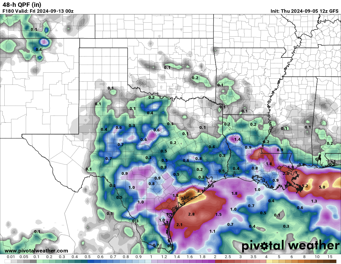
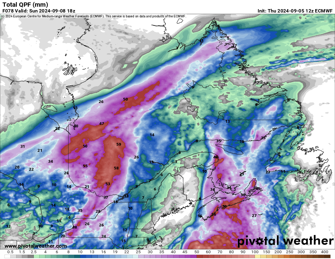
The map above is the GFS model forecast for Wednesday and Thursday next week which shows isolated heavy rain on the Texas coast and near Louisiana, very similar to what we’ve seen this week. Even if no tropical development occurs, a localized flooding concern may emerge again next week on the Gulf Coast of Texas or Louisiana.
Beyond all this, there’s not much else doing out there that’s of concern. There are hints that the widespread sinking air in the background of the Atlantic basin may relax a bit in the final third of the month, but we also saw that possibly happening a few weeks ago and it didn’t. So while I would suspect things could turn more active toward October, I also want to be cognizant of the fact that this a forecast we’ve made before that hasn’t panned out. So for now, we’ll call for a gradual return to more normal activity in the Atlantic heading toward October, which is to say not as active as feared this season but more active than it is presently.
Seems like the storm off the Texas coast is 90L.
The Euro and the GEFS seems to like a wave coming off Africa, but hook out at sea but still needs to be watched.
👌🏻
Is the unofficial end of hurricane season for Texas still around September 25?
Thanks
Yes, generally speaking that’s when our risk tends to drop off significantly.
What is a “permalow”??
As a published author of five books, I have an interest in words.
And I’ve never seen this word, so I Googled:
weather “permalow”
Yes, I quoted permalow because that tells Google to return results that ONLY have that quoted word. Only ONE website was shown in the results:
This website, from today’s post. (Otherwise, maybe, Google search is broken).
So, can someone define “permalow”?
I’d guess “permanent low”, but lows are no permanent 🙂
I made it up. 😉 Yes, your inference is correct: Permanent low. Jokingly, at least. 🙂
There’s nothing wrong with making up words. That’s how words are formed in the first place. Someone makes them up and them others copy them. Sometimes it gets out of hand, such as calling airplane concrete parking ramps Tarmac, which is actually a method of construction from the early Twentieth Century that was never used for airports.
With the low pressure (“permalow”) remaining in the Gulf for so long, how does Houston avoid a huge flood?
The same way we’ve managed to do so since late August: It meanders, never really organizes, and if it does organize all the rain stays offshore. All the moisture offshore and at the coast is “robbing” inflow into Houston, keeping us with just occasional showers or rain. And you have an element of drier air in place this far north with NE/ENE winds.
An interesting paper published by University of Colorado (and explored here) as to reasons for unusually quiet Atlantic basin.
Hypothesis: higher SSTs in Mediterranean and North Atlantic have changed atmospheric pressure causing the Africa Inter-Tropical Front (ITF) to form further north, causing record rainfall over the Sahara but more relevant to hurricane formation: causing tropical waves to form further north and initially encountering less conducive conditions for storm formation.
Worth reading the article and following the link to the Colorado paper:
https://www.netweather.tv/weather-forecasts/news/12618-unusually-wet-sahara-and-quieter-hurricane-season-than-predicted—the-two-could-be-linked