In brief: A disturbance off the Carolina coast has a 40 percent chance to develop heading into the weekend, but it looks to remain offshore. Tropical Storm Dexter may intensify over the open Atlantic as it transitions from tropical to non-tropical late this week, no threat to land. The area in the deep Atlantic with 60 percent development odds remains worth watching but not likely to stir up too much trouble.
Tropical Atlantic
We’ll continue our daily check up on the areas worth watching in the tropical Atlantic — and speculate on what could come next.
Carolina coast
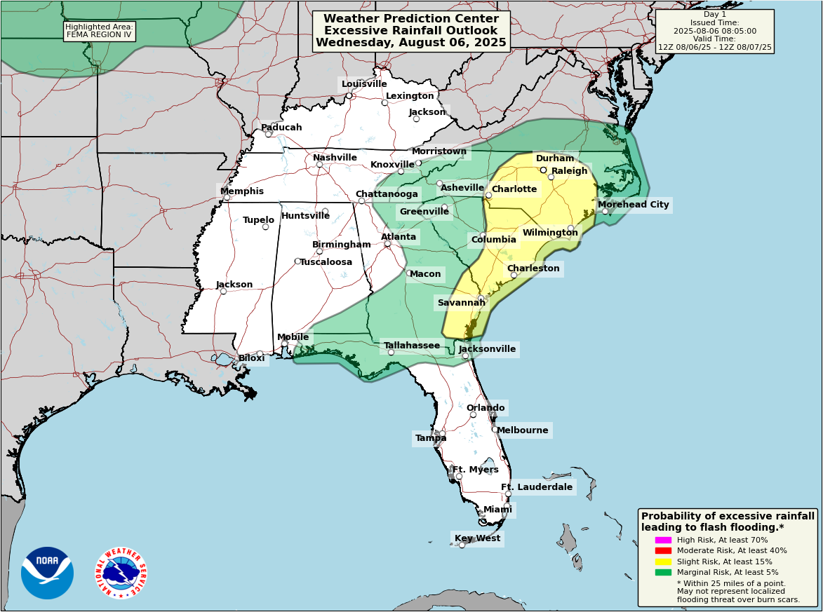
Starting closest to land today, some good news. The disturbance that’s expected to attempt to develop off the coast of the Carolinas appears that it will be less stuck than it appeared earlier in the week. Again this morning, there just isn’t a whole lot there yet.

Initially, the thought was that we’d see development gradually through the week, followed by a very slow-moving or stationary type system off the coast. The first half of that statement is still true. Development will be very sluggish here. We won’t wake up to a tropical storm out of nowhere tomorrow. It may not be until Friday or Saturday that we see anything make a real effort to form. And from there, it now looks as though it will slowly but steadily move north and northeast, heading out to sea. Development odds have been pushed back to 40 percent this morning, indicating that this is not exactly expected to really get going once it does start to attempt development.
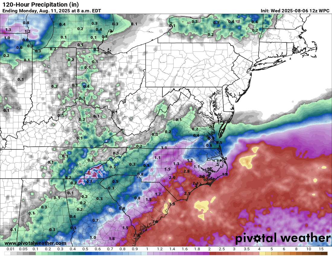
In terms of impacts: Rainfall and rip currents are at the top of the list. You can see the 5-day forecast average rain totals above. Locally higher amounts are possible, especially today in interior North Carolina and Georgia, where flood watches are in effect.
A lot of the rain is actually front-loaded and not directly related to the system itself, but the whole pattern is connected. Rip current risk is moderate to high on the North Carolina coast, and if any development does actually occur offshore, that risk will hold into the weekend. Just something to be aware of if you’re beaching it this weekend in the Mid-Atlantic or Southeast.
Tropical Storm Dexter
Dexter continues to cling to life as it moves out to sea.
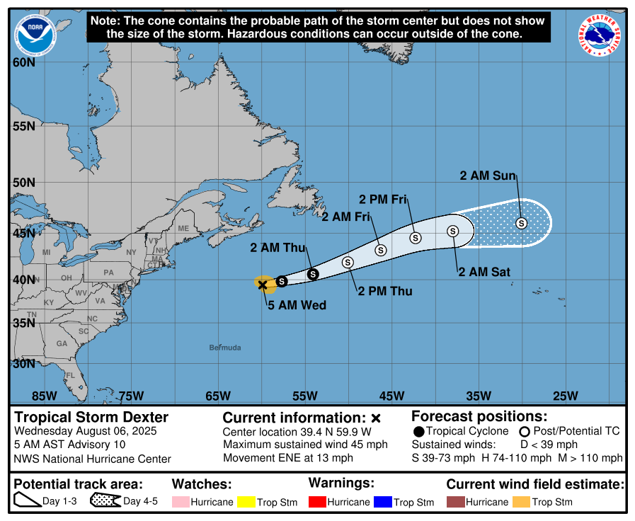
Dexter is expected to become post-tropical tomorrow and end up north of the Azores by Sunday as a non-tropical low pressure. From there, Dexter’s remnants end up getting tied into a storm system near or north of the British Isles by Tuesday or Wednesday of next week. No big impacts are expected right now.
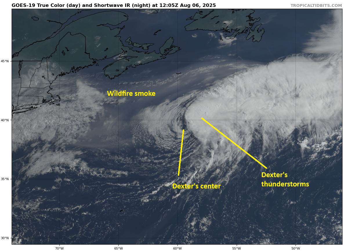
Dexter’s thunderstorms have outpaced the system itself, with the center again almost exposed entirely this morning. That’s a sign of an unhealthy storm. It’s just not in the greatest environment right now, packed with wind shear. That said, tropical systems have a funny way of doing things when they transition to extratropical systems. In Dexter’s case, while it may continue to look very sloppy, it’s likely to increase in intensity, with winds possibly approaching hurricane-force at some point in the next couple days. Thankfully that will remain over the water, though some rough seas could be generated in Atlantic Canada.
Deep Atlantic
We are watching two areas in the Atlantic. There is the one being highlighted by the NHC with a 60 percent chance of development. There is also what will probably be the next highlighted area by the NHC in a day or two.
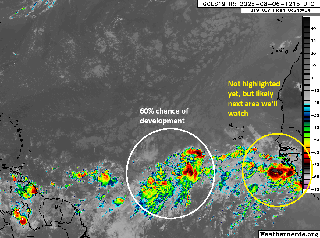
The 60% area looks a good deal better this morning than it has the last couple of days. We will probably see some gradual organization attempt to occur from this one between now and Friday. I wouldn’t be shocked if the 60 percent becomes a 70 or so by later today. In terms of this one’s future, it will probably have a relatively low ceiling for intensity. But a depression or tropical storm seems like a decent possibility at this time.
As the system moves, it will be steered west northwest or even northwest at times around the periphery of high pressure in the eastern Atlantic. By the time it gets to the weekend, high pressure may strengthen somewhat and force to turn back more to the west for a short time. Eventually, it will likely hit the escape hatch and get drawn back northwest and north through a weakness in the high pressure across the basin.
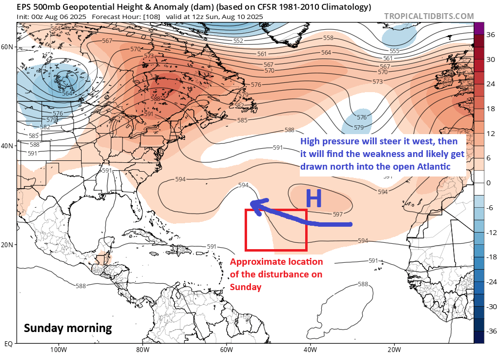
This should allow the system to ultimately turn out to sea. I would say it’s probably worth continuing to monitor for the Caribbean or Southeast or Bermuda, but it’s unlikely to stir up too much trouble.
On the image atop this section, I did highlight the area behind this disturbance as one to watch as well. Model guidance keeps this one a little more southward in the Basin, which could in theory allow it to get closer to more land in 10 to 12 days. There is very little consensus on this one yet though, so for now it’s just probably the next area we’ll watch but nothing more than that.