Headlines
- PTC 6 is now Tropical Storm Francine with 50 mph max winds.
- Francine will accelerate north, then northeast over the next 48 hours, likely making landfall in central Louisiana on Wednesday as a hurricane.
- Francine will intensify, likely peak just offshore of Louisiana, then come ashore steady or slightly past peak, still bringing hurricane impacts to central Louisiana.
- Interests in the New Orleans metro should continue monitoring for any track shifts, while interests in Baton Rouge, Lafayette, and the rest of central Louisiana should prepare for direct impacts.
- The Houston area is unlikely to see any serious impacts from Francine.
- Flash flooding is likely across parts of Louisiana, perhaps into Mississippi and Tennessee, as well as in the Brownsville, TX/South Padre Island areas.
Francine now
We can retire Invest 91L and PTC 6 from the lexicon. As of 10 AM CT, Tropical Storm Francine has been declared by the National Hurricane Center (NHC).
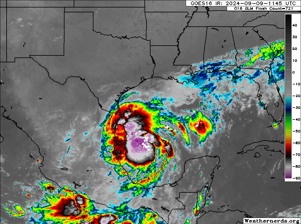
Francine looks the part for sure. We will have reconnaissance aircraft from NOAA and the US Air Force Hurricane Hunters in there throughout the day gathering additional data on Francine’s center and intensity.
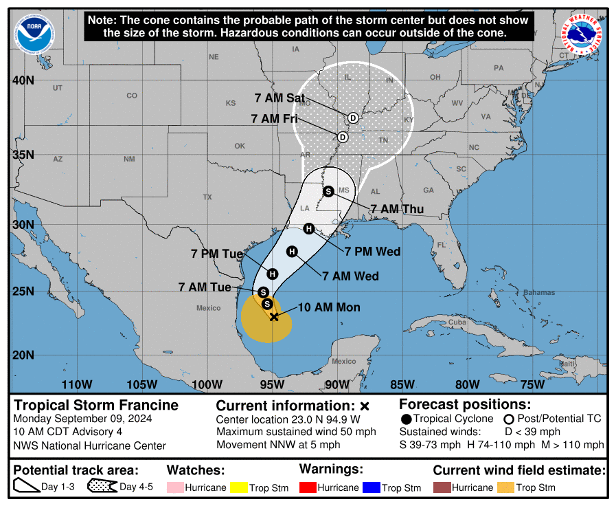
Francine track
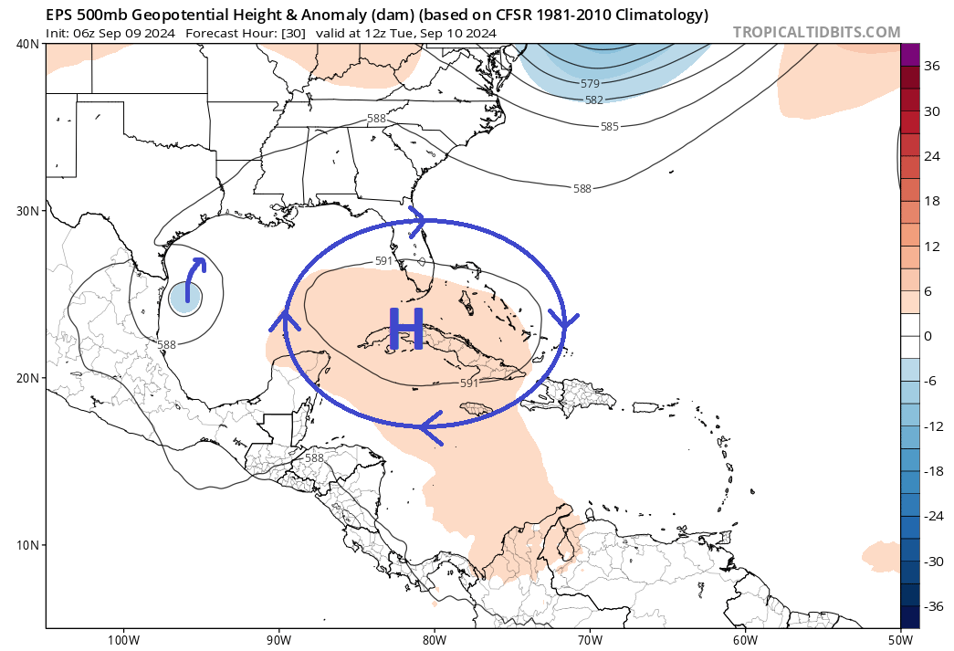
Tropical Storm Francine will be broadly steered by high pressure over the Florida Strait which will allow it to track north and then northeast, hence the growing confidence of a track into Louisiana.
I have dealt with a lot of tropical systems over the years, and while there is nuance on the where the final landfall point will occur, this is a relatively straightforward track forecast.
For Houston folks: This is likely not a Hurricane Beryl situation where there will be a dramatic last-minute shift into our area (and if that did happen, it would be as a much weaker storm than currently forecast, which judging by satellite imagery today seems highly unlikely).
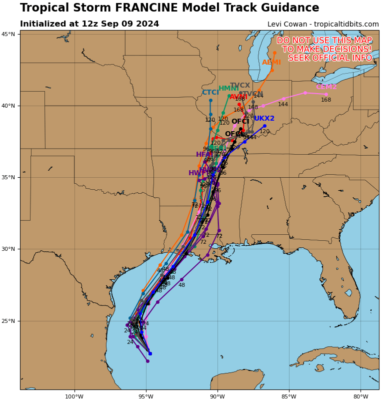
For Baton Rouge and New Orleans folks: This is one you want to watch. If for whatever reason this goes ballistic over the Gulf, it could allow the track forecast to keep shifting east, putting the metro areas in play for significant direct impacts from wind. This is especially true for Baton Rouge, but I think New Orleans should watch things closely.
Francine impacts
Let’s discuss some of those impacts. Francine will come north in an environment that is hospitable to intensification. Expect a steady, if not rapid strengthening (RI) trend with Francine over the next 36 hours. RI probabilities for various thresholds are around 5 to 7 times greater than climatology for this over the next 36 hours. This indicates that there is a good chance this storm becomes a hurricane in relatively short order. Francine will continue strengthening until about Wednesday morning. It will then encounter wind shear values of 20 to 35 kts aloft, which usually will help degrade a storm. This should lead to a peak intensity about 75-100 miles off the Gulf coast, then a steady state intensity or slow weakening on approach to landfall. While it should still come in as a hurricane, it would likely be just past peak intensity.
Winds
For Louisiana, this will likely mean widespread tropical storm to hurricane force winds between about far eastern Cameron Parish and the western fringe of New Orleans. On the current track. If the track shifts east further, this will push east as well.
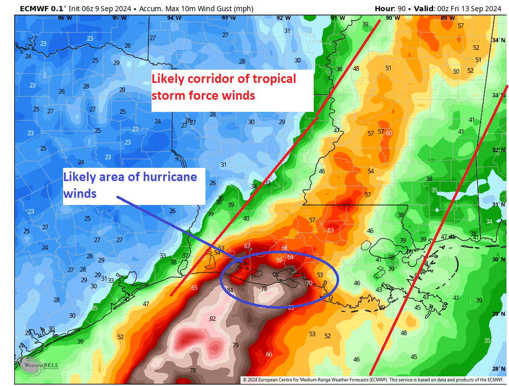
So folks in central Louisiana should be preparing for hurricane-force wind impacts, while folks in eastern Louisiana should continue to monitor for potential track shifts that could bring them more into play for that. Winds should reach the coast sometime later tomorrow night and Wednesday morning.
Surge
Storm surge is expected to be on the order of 5 to 10 feet at peak above ground level, primarily from eastern Cameron Parish through Port Fourchon. We’re looking at about 2 to 4 feet in Lake Pontchartrain in New Orleans.
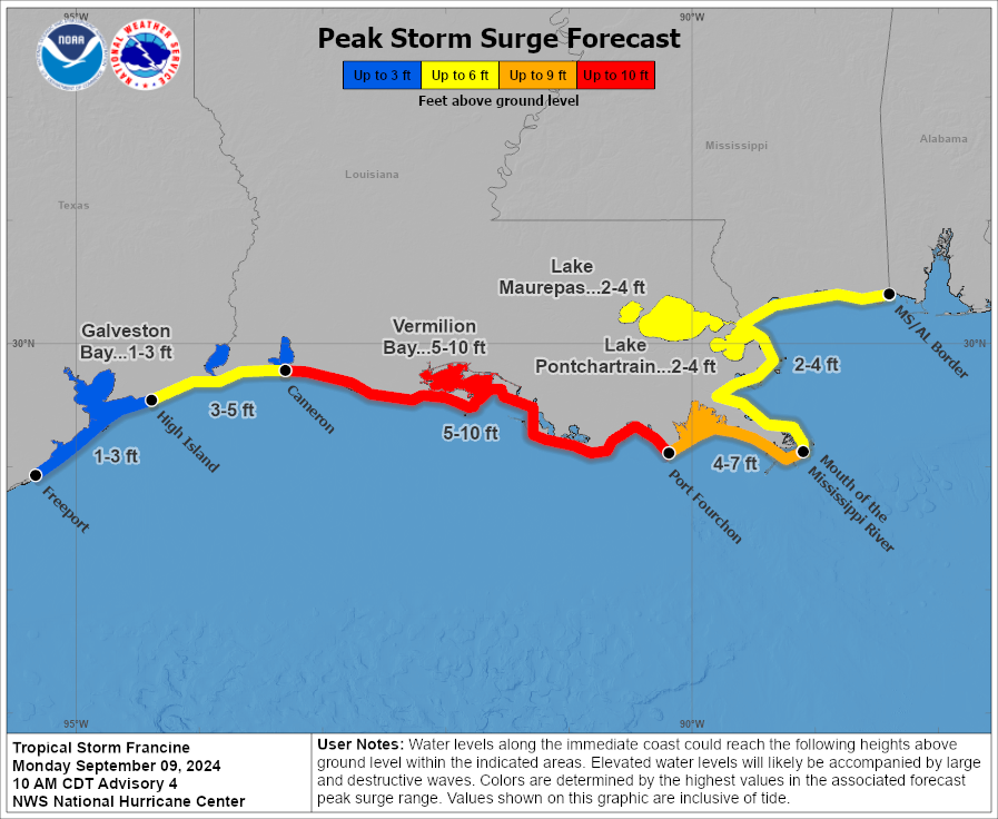
This will likely produce some potential damage in central Louisiana and flooding in eastern Louisiana outside of levee protection. Follow local authorities for any details on evacuation orders or preparation tips for Francine.
Rainfall
The good news is that Francine will be moving rather fast, so this could functionally limit how high maximum rain totals get along the track.
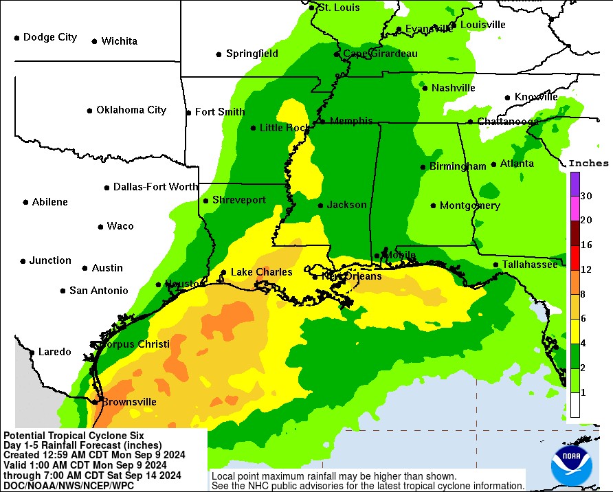
That said, it will still produce a lot of rain. The highest rain totals should be in central Louisiana, including both Lafayette and Baton Rouge where 6 to 12 inches of rain is possible. New Orleans should see on the order of 3 to 6 inches. While Houston is currently projected to see 1 to 2 inches, that may be a bit generous.
Notably, while it may generate only a passing mention, the Brownsville area into South Padre Island could actually see a healthy amount of rain on the order of 6 to 10 inches from this as well as Francine organizes offshore over the next 36 hours. Flood Watches are posted there and in southwest Louisiana. We could see additional flash flooding up into portions of northern Louisiana, Mississippi, and Tennessee as well as Francine lifts inland.
Tornadoes
As always, landfalling tropical systems occasionally produce isolated tornadoes, and this storm will be no exception. The risk of tornadoes will be highest between Vermilion Bay and Mississippi, possibly as far east as Mobile Bay as well.
Quick comment on Louisiana metros
As noted above, while the current forecast track will keep the highest impacts in central Louisiana, folks in New Orleans should continue to closely monitor Francine’s progress. Lafayette and Baton Rouge will see strong winds, heavy rain, flash flooding, and potential isolated tornadoes. Scattered to numerous power outages are likely there. New Orleans will see minor surge impacts, flash flooding risk, and some wind. Isolated to scattered power outages are likely, with greater impacts possible if this comes farther east.
Please ensure you’re prepared to deal with some hot weather if you lose power for a few days behind this storm. Forecast highs look to be in the mid to possibly upper 80s on Thursday and Friday after the storm passes. Thankfully, the humidity levels should be near to below average for a couple days.
Elsewhere, we have no tropical concerns as they relate to land.
Our next update will be this evening before the 10 PM NHC advisory, probably around 7:30 PM.
Oh thank you that it’s not coming straight at Houston. I think we’ve paid our dues this year with the Derecho and Beryl. If this thing wobbles at Houston, we’ll be holding our collective breath that it will wobble back on its track to share the hurricane season with Louisiana!!! (LOL!)
Sounds like something a Katrina would say.
Will it make landfall Thursday or Friday
Wednesday afternoon.
What are the models showing for the other two systems in the Atlantic?