In brief: The most significant coastal storm impacts since at least 2016 will unfold across the coast north of Virginia over the next couple days. Expect major tidal flooding and severe beach erosion on the Jersey Shore south of LBI through parts of Delmarva. In addition, gusty winds will likely cause power outages and some damage. Less impacts as you go north into NYC and Long Island but still stormy. Elsewhere, more rain coming out west after rainfall produced mostly as expected yesterday into this morning.
Biggest coastal storm impacts in 10 to 15 years for Delmarva and New Jersey
Looking at things this morning, we have a very significant coastal storm winding up off the Southeast.
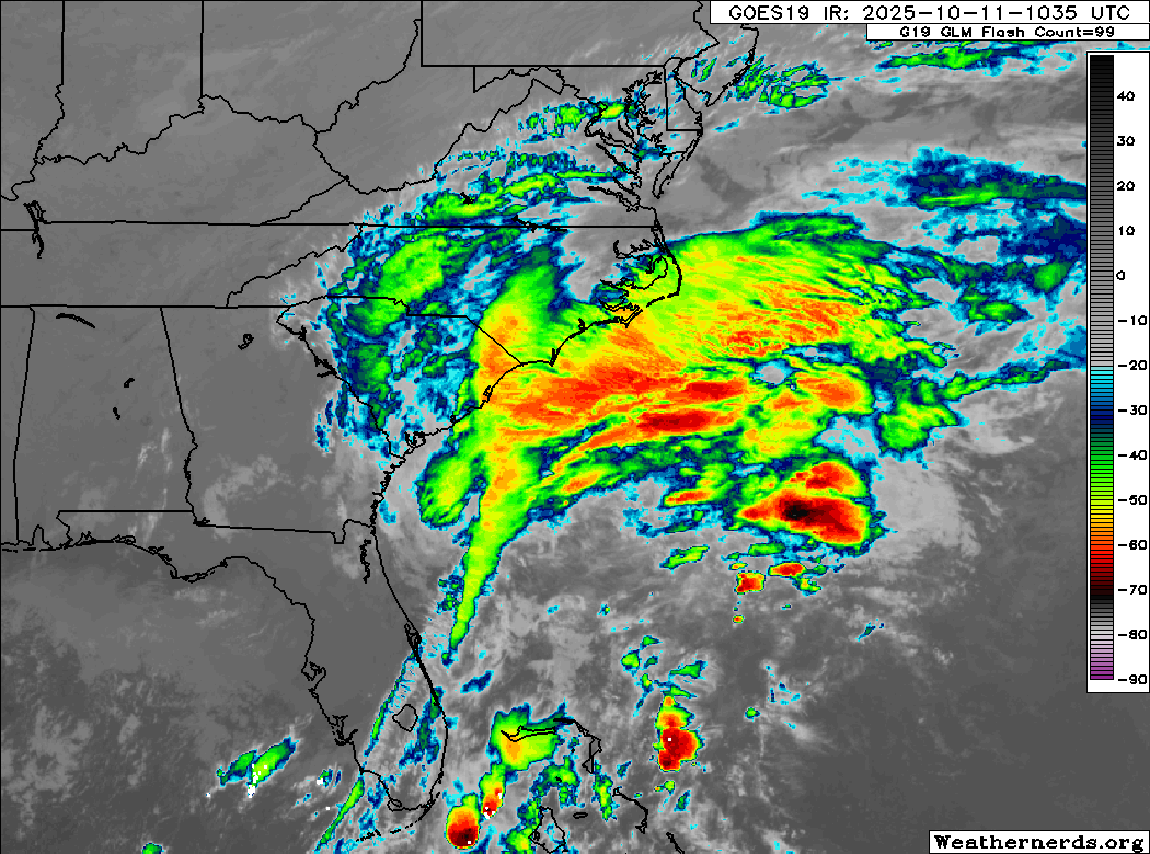
As a meteorologist, you can look at this and tell immediately that this is not tropical. One key factor is the presence of fronts. You can generally pick out the warm front and cold front attached to the low pressure at the surface, thus this remains firmly non-tropical. But that doesn’t matter beyond semantics.
Thus far, winds have been gusting to about 30 to 35 mph on parts of the coast between the Outer Banks and Florida’s First Coast. We have seen some 40 to 45 mph gusts today around Jacksonville on the backside of the system. Thus far, wind has not been much of an issue, but we do expect gusts to increase as the storm winds up and moves northward. What we’ll actually see in terms of storm center(s) remains to be seen, but in general, winds will begin to rev up. Wind gusts upwards of 50 mph will be possible around the Tidewater of Virginia and up the coast of Delmarva into New Jersey (more below) on Sunday.
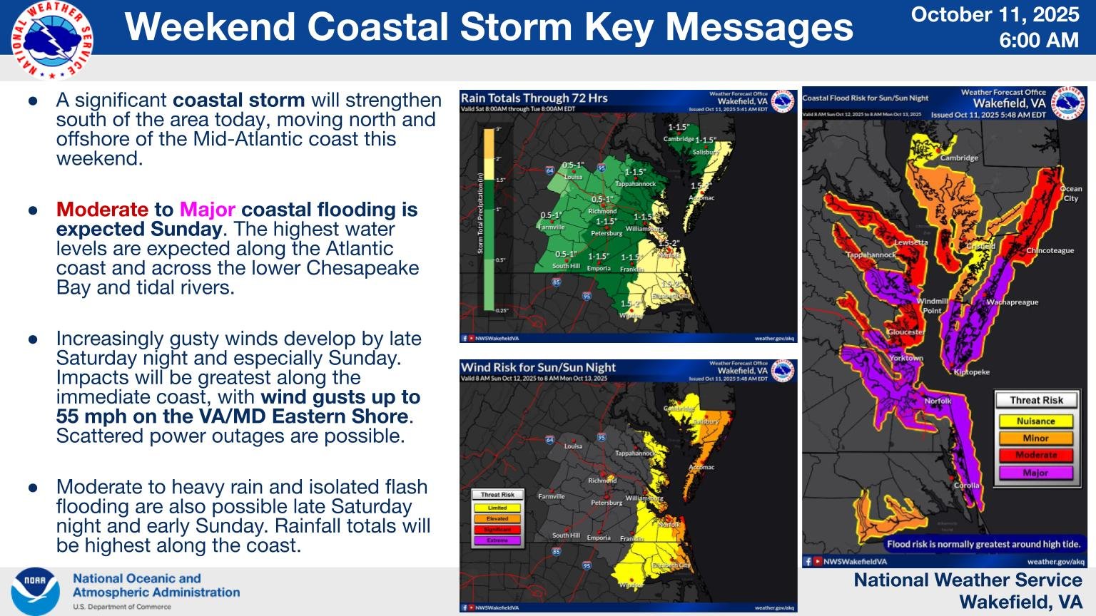
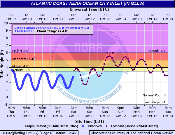
This will also impact Virginia and parts of North Carolina with major tidal flooding. The current tidal forecast in Norfolk is about 1 foot higher than experienced earlier this summer and the highest since Hurricane Joaquin in October 2015. Up the coast in Ocean City, MD, the tidal forecast is 5.6 feet MLLW on Sunday will be the highest since Hurricane Sandy and the 4th highest on record. It would appear that two high tide cycles will come close to that.
Heading up into Delaware and New Jersey, the coastal flooding and erosion threat is very, very serious.
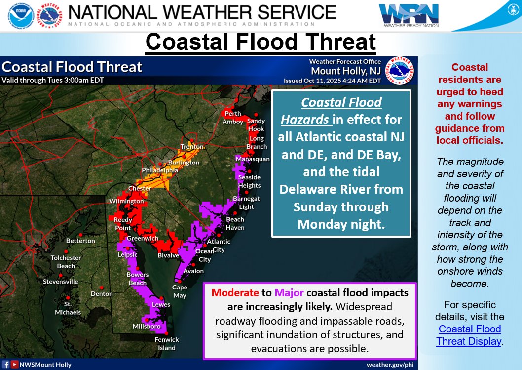
In Lewes, DE, tides are forecast to peak around 8.4 feet MLLW on Sunday. This would be seventh highest on record and highest since January 2016 (less than a foot lower). The period of record is shorter, but for Bowers Beach on the Delaware Bay further north in Delaware, tides should exceed any level experienced in the last 15+ years. For Cape May, NJ the 9.36 foot record looks safe, but even still, 8.4 feet is forecast, which would be third highest and highest since 2016.
For those that remember the very, very bad back bay flooding during Hurricane Sandy in the Atlantic City and Ocean City areas, thankfully this currently looks to peak about 2 feet under those levels. This would still be the highest since 2016 and fourth highest all-time.
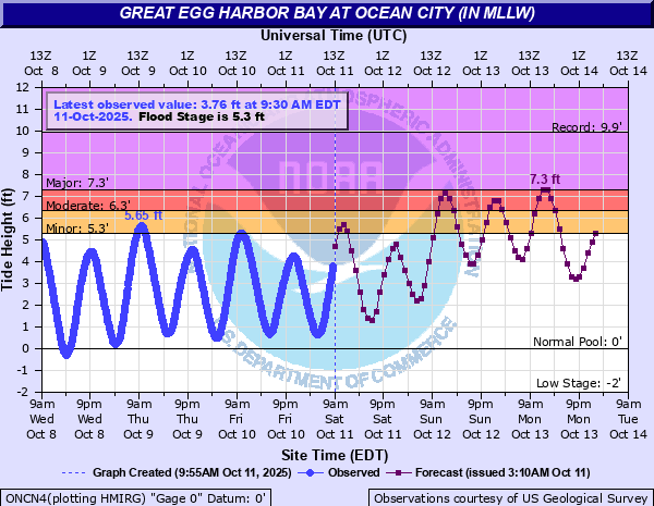
The 8.1 feet in Atlantic City would be the highest since Sandy (8.8 feet). Same up on LBI at Barnegat Light (5.7 foot forecast vs 6.4 feet during Sandy). Tidal flooding issues become more moderate to minor north of there. Basically, from Long Beach Island in Jersey, south into Delaware Bay, then south to the Outer Banks, this will be a significant, if not major tidal flooding event. Combined with rough surf, this will also be a major beach erosion event.
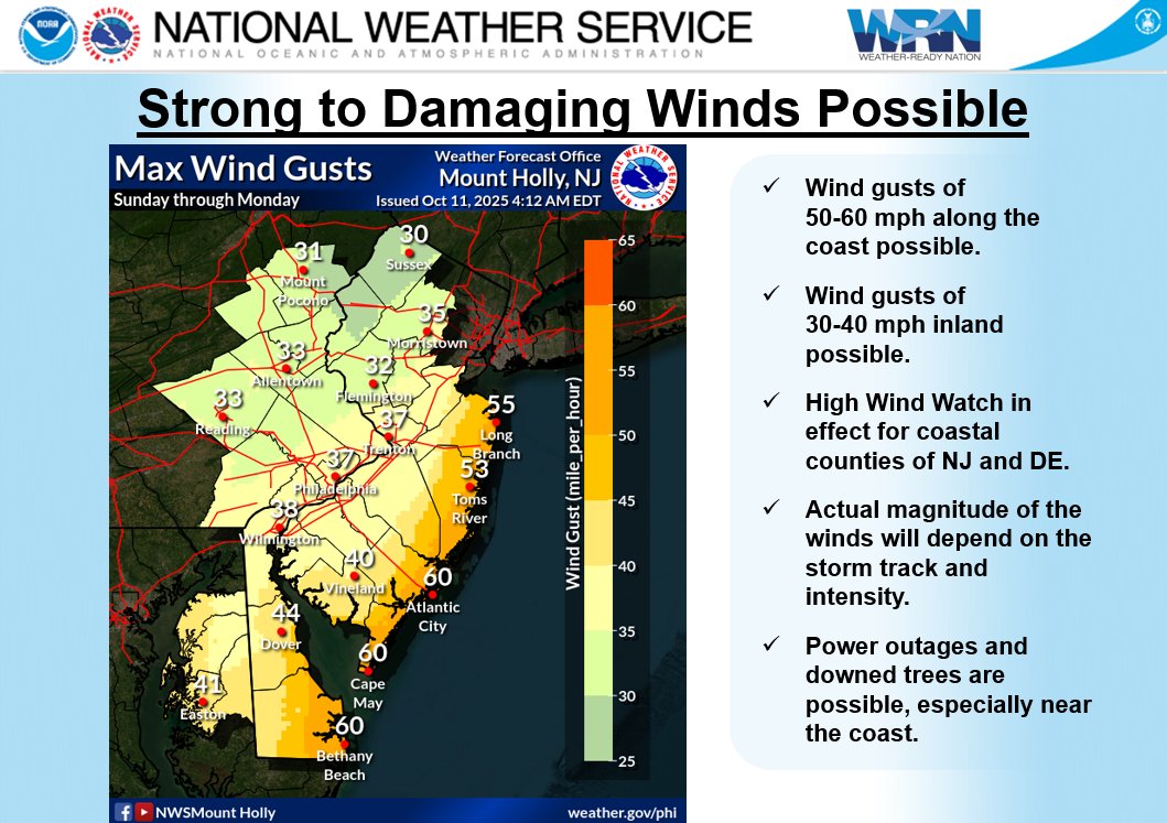
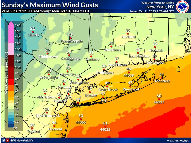
Wind gusts up the coast will be 50 to 60 mph for the Delmarva coast and Jersey Shore. As you go north from there, the wind gusts start to drop off a bit. Look for gusts of 35 mph in most of New York City, except 40 to 50 mph perhaps for Brooklyn and Queens, as well as for Long Island. Locally higher gusts are possible on the south shore of Long Island.
These winds will be capable of bringing down tree limbs and power lines, particularly in New Jersey and Delmarva. Winds will drop considerably as you move inland from the coast, but it will still be rather breezy.
Widespread rain totals of 1 to 3 inches are likely up and down the Eastern Seaboard. Much of this will be welcome rain, as there is lots of dryness and drought in this area, but locally heavy downpours will cause urban and flash flooding, particularly where tidal flooding is exacerbated by the heavy rainfall.
Bottom line: The most impactful nor’easter slash coastal storm in about 10 to 15 years will bear down tonight and tomorrow across the Mid-Atlantic coast up through Jersey and Long Island. Expect significant problems, disruption, and potentially damage in this region.
Western storminess
Meanwhile, out west things continue to be active. Flood Watches continue for much of the Desert Southwest. Anywhere from 2 to 5 inches of rain fell in the Mongollon Rim. Phoenix has seen just shy of an inch so far officially, with higher amounts on the southwest side of Mesa and up in Deer Valley. Significant rains also fell in southern Utah as expected and southwest Colorado.
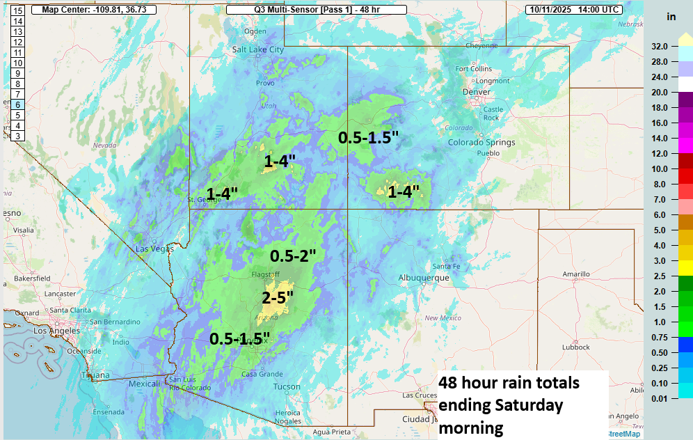
Additional rains are likely today, particularly in Arizona, southwest Colorado, and New Mexico. Tucson, which has seen little to no rain so far should see an inch or two over the next 48 hours. Much of New Mexico will be the same, with perhaps an inch or so even into El Paso.
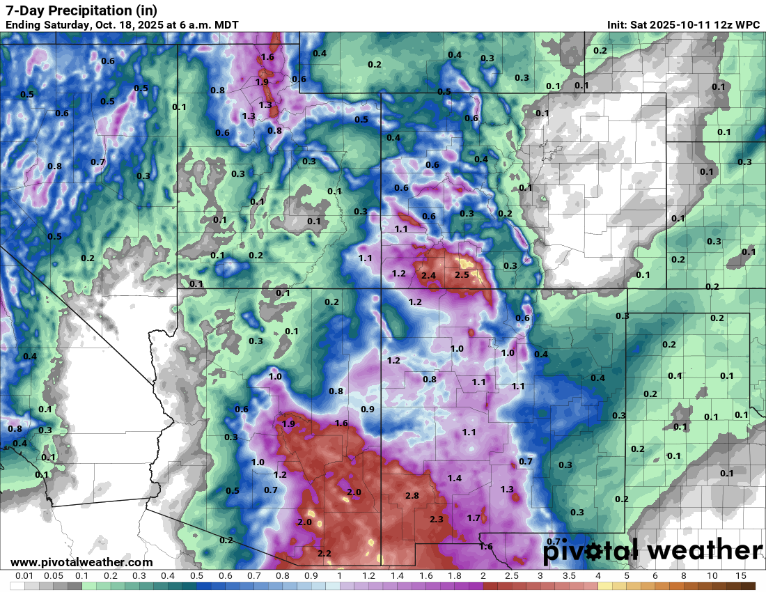
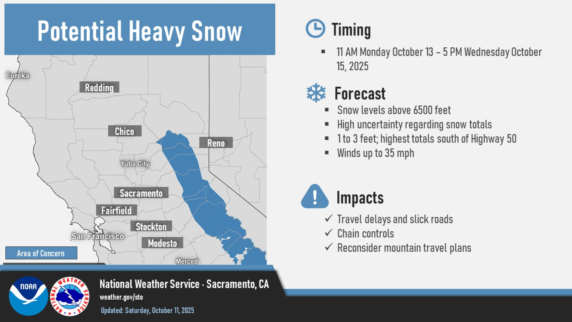
Meanwhile, a major early winter storm will bear down on California next week, a spectacular start to the water year. Heavy snow is likely in the Sierra at high elevation, while heavy rain is possible across lower elevations, mostly in northern and central California.
More to come on this. Check out Daniel Swain’s excellent blog for more as well.
For the tropics, other than Jerry heading out to sea, we’ve got little else to talk about.