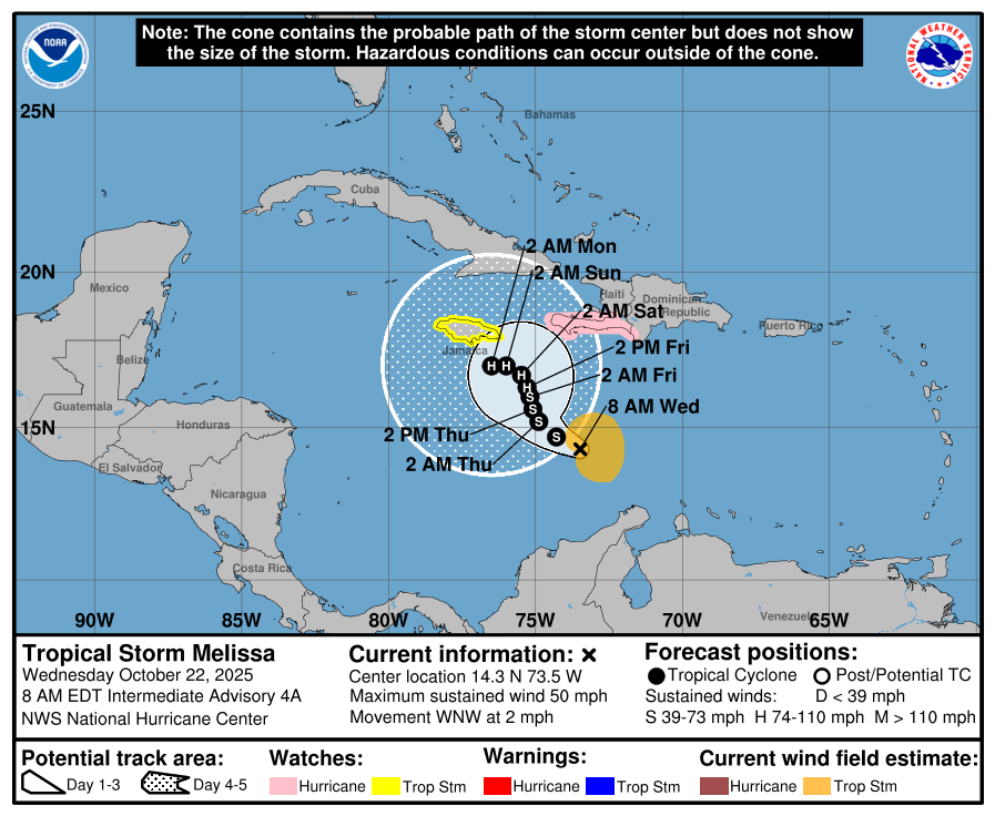
In brief: Tropical Storm Melissa is unfortunately looking to be one of the most impactful storms of the Atlantic hurricane season, with several days of high-end impacts possible for places like Jamaica and Haiti. Risks of a high-end major hurricane, along with catastrophic rainfall exist in these areas through the weekend and into early next week. Melissa is not a threat to the U.S. at this time, though it may graze the Bahamas or Turks and Caicos on its way out next week.
Invest 98L was upgraded to Tropical Storm Melissa on Tuesday, in what looks like the beginning of the climax of the 2025 Atlantic hurricane season. The forecast track for Melissa is troublesome.
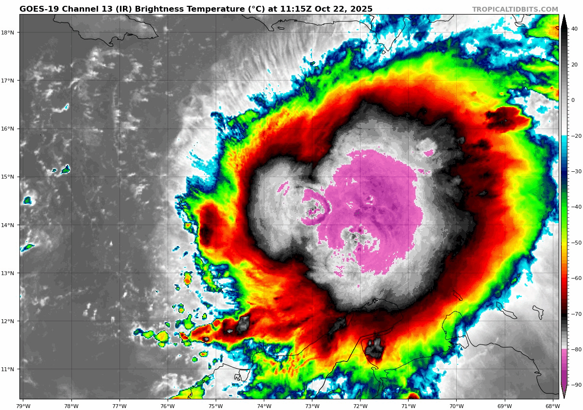
Melissa is expected to crawl, I mean crawl in the central Caribbean over the next several days. Melissa is not terribly well organized this morning, though its satellite appearance is rather ominous. In fact, the center is fairly heavily displaced to the west within the deeper thunderstorm activity indicated by the brighter white and pink/purple colors on the satellite image below.
Maximum sustained winds are 50 mph as of the 8 AM advisory. We’ll see if that nudges up for the 11 AM ET one. There is currently a Hurricane Watch for southwest Haiti from Port-Au-Prince to the border with the Dominican Republic. A Tropical Storm Watch is posted for Jamaica. These watches could be upgraded to warnings and/or adjusted further later today.
Melissa’s slow track forward
So where is Melissa going to go? The billion dollar question, of course. Yesterday, it seemed we had a consensus of slow-moving and eventually a sharp turn north or northeast, perhaps toward Hispaniola. That’s still on the table, but the key now may be the “slow-moving” aspect of it all. Over the next 2 days we’ll see very slow west-northwest movement and drift. By Friday morning, we expect to see Melissa sitting just southeast of Jamaica.
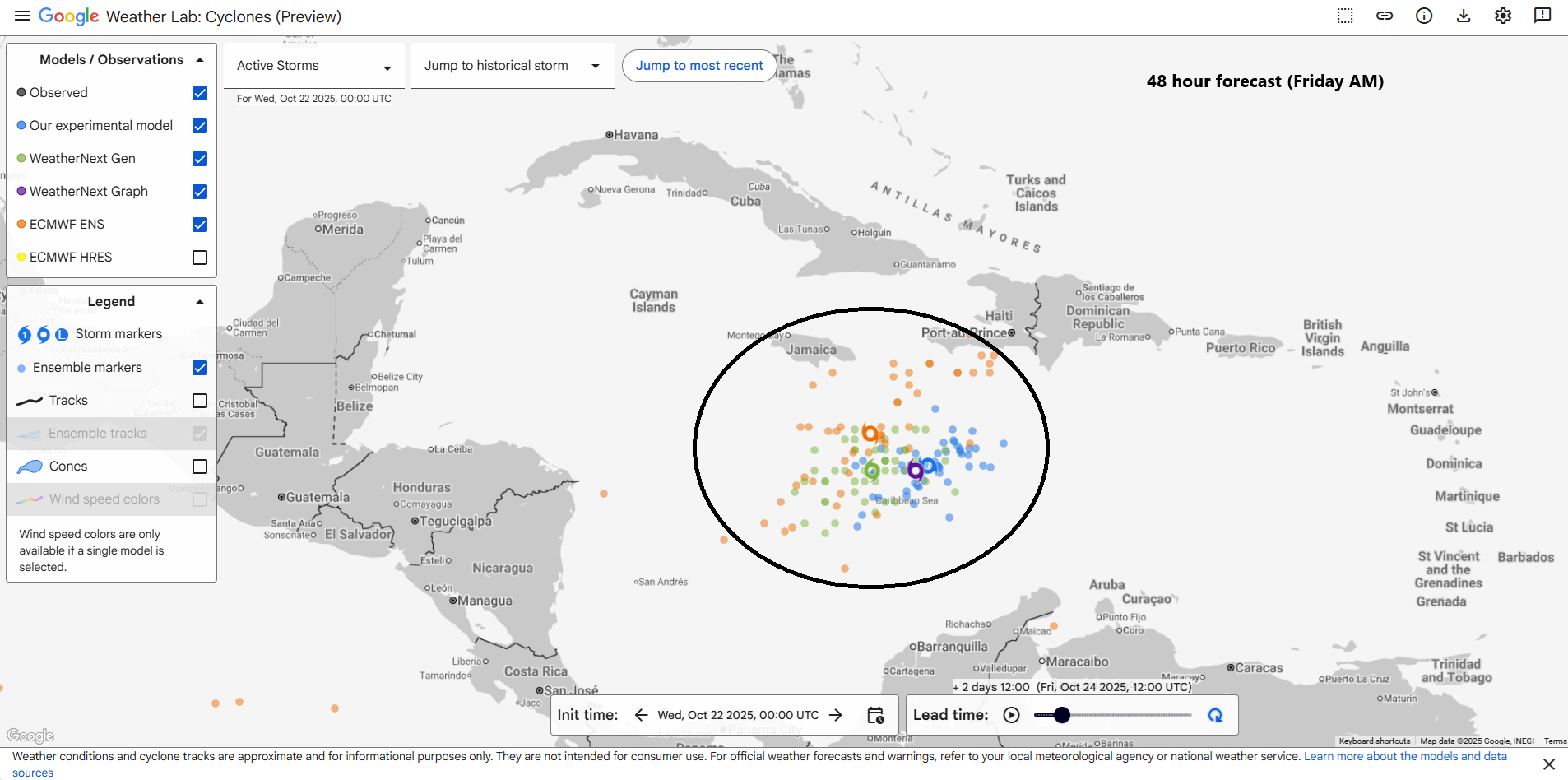
A continued northwest-ward drift is expected to continue beyond Friday, but from there, it gets a lot more complicated. Steering currents are meager at best in the Caribbean, meaning that we may see Melissa drift west even beyond this weekend into next week. It may take until later next week for a strong trough in the upper atmosphere to actually capture Melissa and steer it north and out to sea.
Of course, if Melissa just continues slowly drifting west, that may mean days of impacts for places like Haiti and Jamaica and possibly even eastern Cuba, the Cayman Islands or portions of Nicaragua and Honduras.
How strong will Melissa get?
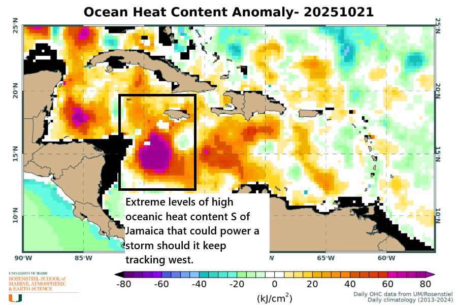
Oceanic heat content is always high in the Caribbean, but this year it’s very, very high.
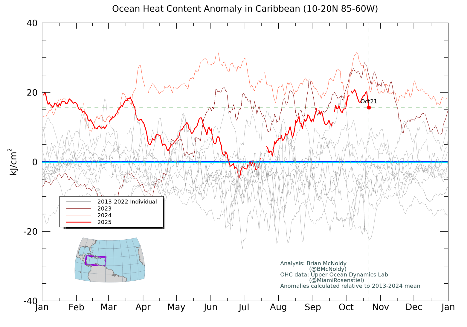
In fact, based on Argo buoy temperature reports from the Caribbean, 30°C water extends down about 180 feet below the surface of the Caribbean. It’s deep, rich, warm water. Particularly if for some reason this ends up west of Jamaica, the oceanic heat content there is incredibly high.
Truthfully, the only things that may inhibit intensification of Melissa is land and time. Wind shear is always a concern, but frankly, there’s nothing that stands out dramatically right now, certainly nothing that says this will falter. If Melissa drifts west to south of Jamaica where that patch of extreme oceanic heat content lies, we could easily be talking a category 4 or 5 storm.
So steady intensification is likely for Melissa over the next couple days. Odds of rapid intensification upwards of 75 mph in the next 3 days are almost 5 times normal. Bottom line: There is likely to be continued intensification of Melissa and based on the track, the ceiling could be extremely high.
Rain forecast
Regardless of the track and intensity, someone, perhaps a lot of folks will see heavy, heavy rainfall in the Caribbean.
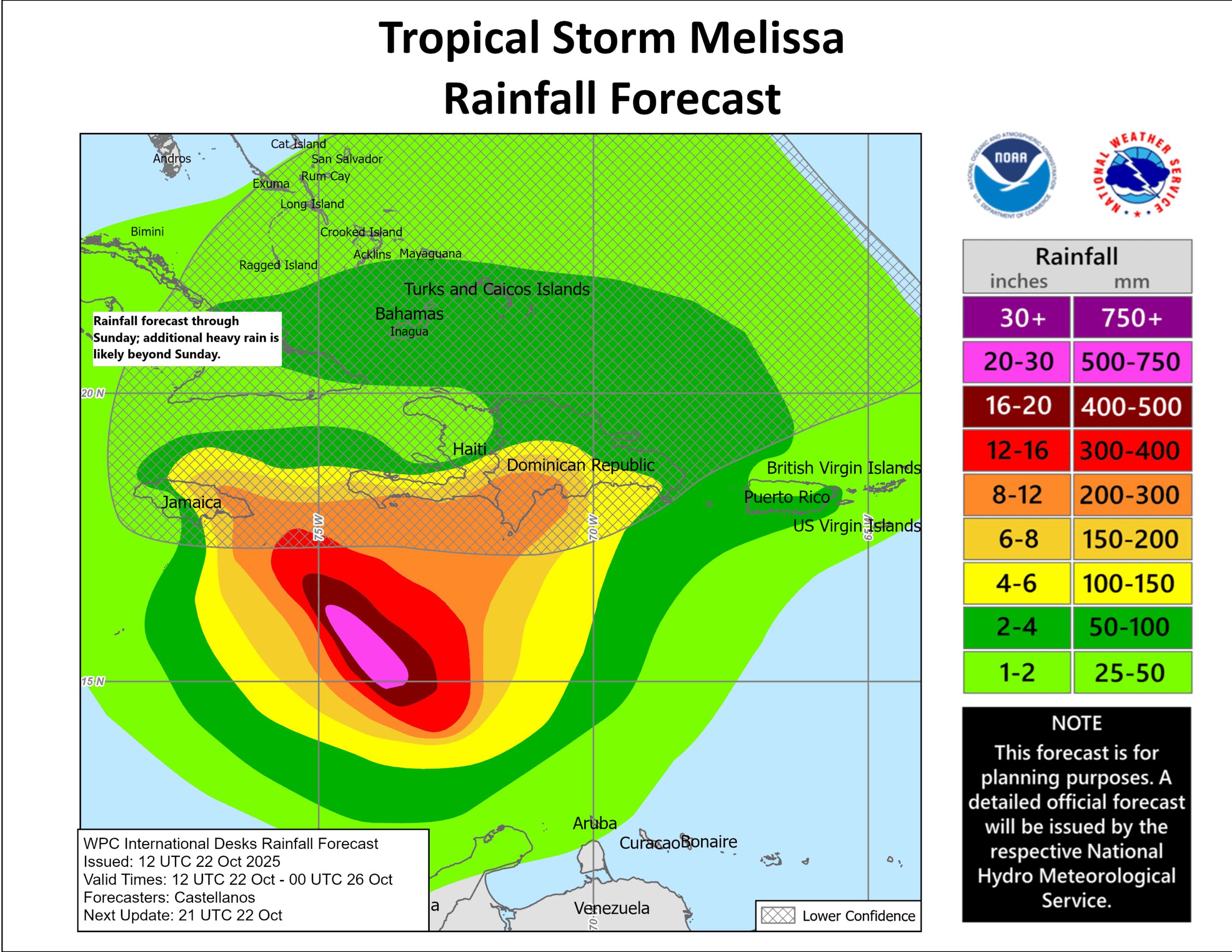
When all is said and done next week, it is not out of the realm of the possible for some places to see 20 inches (500 mm) or more of rainfall. This could be catastrophic in some places, including portions of Jamaica and Haiti or the southern Dominican Republic as well. Just really bad news with a slow-moving Melissa.
In summary:
- Melissa is going to move slowly over the next 5 to 7 days over some of the warmest, deepest warm water in the Atlantic Basin.
- Intensification into a hurricane and major hurricane seems likely at this point, with a high-end category 4 or 5 in the realm of the possible.
- Impacts may be severe depending on the exact proximity of the storm to Haiti and Jamaica.
- Heavy rain, flooding, mudslides, and severe water impacts are possible, if not likely in portions of Jamaica, Haiti, and the Dominican Republic.
- All areas in this region should be prepared for multiple days of high-end impacts.
- The storm is not expected to threaten the US, but it will eventually turn north and northeast into the Atlantic, possibly impacting the Bahamas or Turks and Caicos Islands on the way out.
More to come on this, possibly later if time allows.