Headlines
- Milton has become a tropical storm in the southwestern Gulf of Mexico
- The storm is likely to undergo significant intensification over favorable waters during the coming days
- In all probability, a major hurricane will approach the western coast of Florida by mid-week
- Some locations in western Florida have not experienced a powerful hurricane like this in several decades
Meet Milton
At 5 pm ET on Saturday, the National Hurricane Center upgraded a tropical depression in the extreme southwestern Gulf of Mexico into Tropical Storm Milton. The center of the storm is nearly stationary this evening, but it should start to move slowly to the east over the next day or so before accelerating. Although it is unusual for a tropical system this far west in the Gulf of Mexico to move toward Florida, that’s exactly what we expect to happen over the next four days in response to blocking in the mid- and upper-levels of the atmosphere.
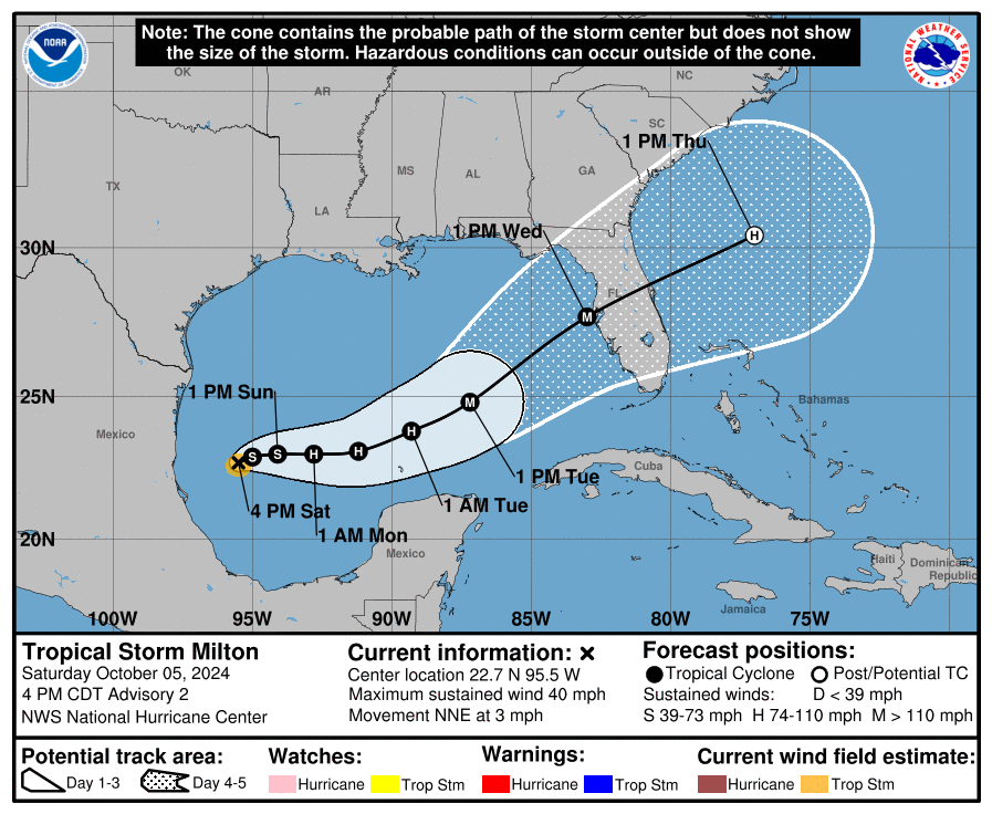
Although we remain about four days—give or take—from a landfall along the west coast of Florida, it is important for residents of the state to take Milton very seriously. We realize that some areas of the state remain dazed by Hurricane Helene, but this is a similarly threatening storm. Although we don’t have full confidence in precisely where the storm will track, it does seem very possible that it will directly impact the greater Tampa-St. Petersburg-Clearwater metro area, which has a population in excess of 3 million people.
Please remember that the forecast can and will change in the coming days. However, we have seen a fair amount of tightening in the model solutions over the last 24 hours, and increasingly they are pointing to a powerful hurricane approaching the western Florida coast, possibly near or north of Tampa Bay, by around Wednesday of next week. This post will discuss our preliminary assessment of some of the impacts from this storm.
Track and intensity
There remains a broad cone of uncertainty in regard to where Milton will go, but we can expect this to narrow somewhat during the next day or so. After Milton wobbles around the southwestern Gulf of Mexico for the next day or so, it will get picked up by a front moving down into the northern Gulf of Mexico. This will help steer the storm the east, and then the northeast over the next few days.
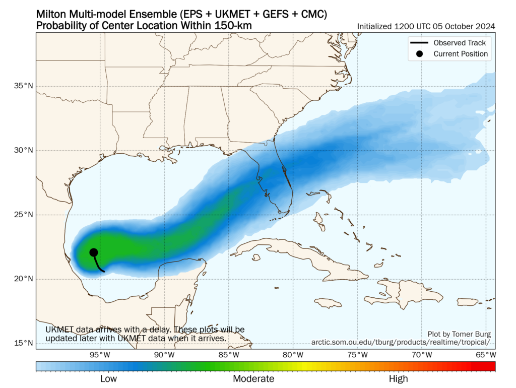
Most of our best modeling guidance, including hurricane specific models such as the HWRF and HAFS, brings the storm to the western coast of Florida, near the Tampa Bay region, very late on Tuesday night or Wednesday. Now that a fairly well defined center of circulation has formed, I expect modeling agreement to increase over the next day or so.
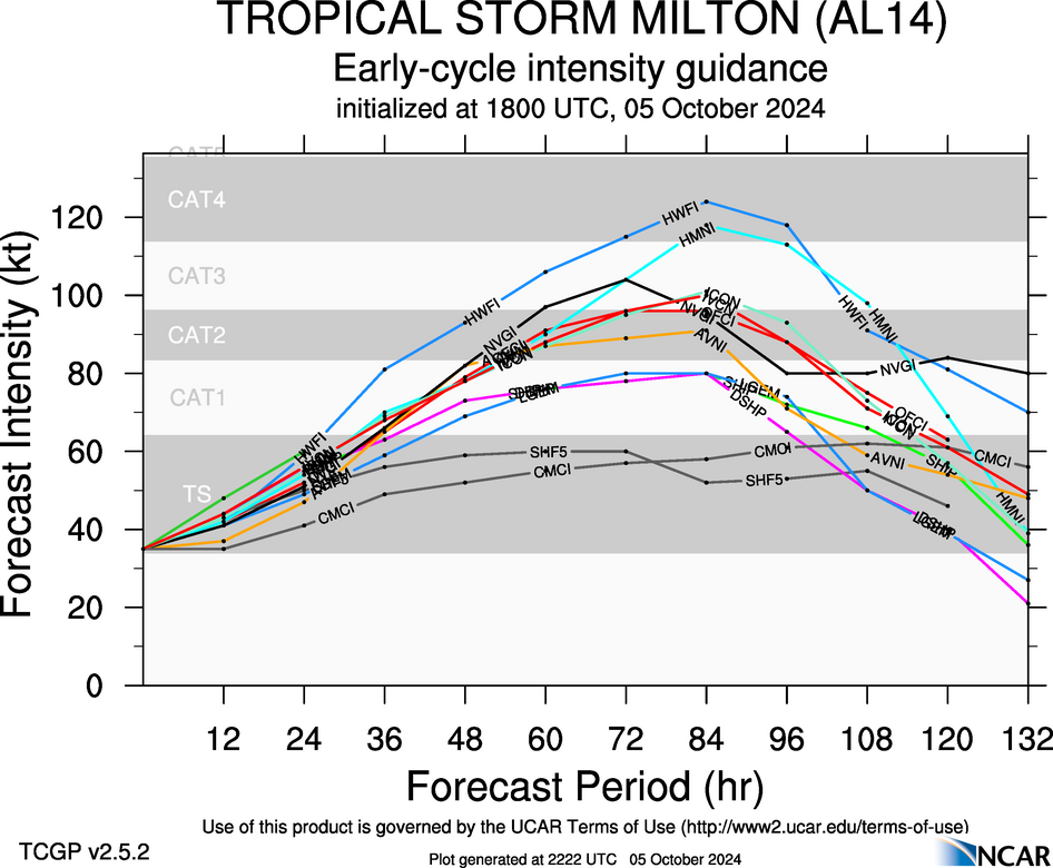
In terms of intensity, there is a broad range of outcomes. The National Hurricane Center predicts a major, Category 3 hurricane at landfall on Wednesday. However, an even more powerful storm is possible given that the Gulf of Mexico is very warm, with deep oceanic heat content, and wind shear levels unlikely to disrupt Milton’s organization. Unfortunately, this is a setup for the development of a large and powerful hurricane.
Winds
Milton’s track will determine where the storms strongest winds occur; they will be along the path of the center and generally just to its right. The majority of our guidance continues to point to a hurricane somewhere between Category 2 and Category 4 intensity, which means that there is the potential for a large stretch of the Florida peninsula to experience hurricane-force winds. This level of winds will cause significant damage and likely lead to power outages.
Storm surge
With four days to develop, Milton is ultimately going to push a large and powerful storm surge toward Florida. This storm will almost certainly impact areas south of where Hurricane Helene struck in September, but at this point anywhere from the coastal bend of Florida, south to the Tampa Bay area, and further south to Fort Myers, is at risk. It is too early to talk about absolute risks, but for wherever Milton makes landfall, the storm is likely to bring a historically damaging storm surge. These impacts will be most pronounced just to the right of where the hurricane makes landfall—which again, is a location that we cannot say with any certainty yet.
Inland rainfall
Heavy rainfall is another threat from Milton. Although the storm should be moving at a fairly good clip once it reaches Florida by the middle of this week, Milton could nonetheless drench a swath of the state, from west to east as it crosses the state. Whether this occurs in the central part of the state, such as the vicinity of Orlando and the Space Coast, or further north in the coastal bend and Jacksonville, is just not clear yet. However, the risk is there for 10 or more inches of rainfall in a short period of time, which will lead to flash flooding.
Conclusions
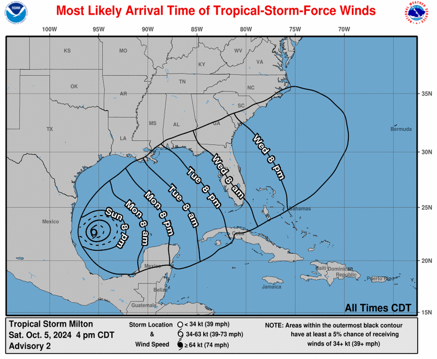
If you’ve read this post up until now, you’ll realize that we cannot say much more at this time beyond stating that a serious hurricane threat is coming to the state of Florida this week. Sunday and Monday will be a time for preparations, as impacts such as wind and heavy rain are likely to reach the state as early as Tuesday evening.
We will have continuing coverage on The Eyewall as this very serious threat develops.
Well done narrative yet again. I am a hurricane worrier and your coverage gives me a good window into the storms. Living on Galveston that’s a good thing.
Well dones.
Bust of an Active Season
Said no Floridian r n
SimplieAmazing: Unfortunately it only takes one, and it looks like Florida will get three with Milton. And it doesn’t have to be an active season. 1983 saw only four named storms out of seven depressions, but one of them was Hurricane Alicia which I’m sure those who were in Houston/Galveston remember well.
It was sarcasm?
Born in FL, live in Houston, followed Eric at Chron long before SPC ever exhisted..I like to think I’m fairly hurricane season knowledgeable.
I have FL colleagues, in the path.
who run medical for 1200 bed Memory Care facility/ pharmacy.
Was just told they must stay on site Monday night…until released.
They got lucky w Helene.
ERIC/MATT – they are following this Blog now. And grateful.
I am currently in Orlando with my family for a trip. Got here today with a plan to be here all week.
How much more will we know about trajectory and intensity by Monday PM?
Hunker down Wednesday night.
Prayers for FL 🙏🏻⚘🙏🏻
Please make a prayer chain/circle. Desperately need it 🙏
Guess you guys called the season over too soon. It continues to amaze us all. Enough all ready!
They called the Texas season, not the Atlantic season.
Sb: Yep, and I think they said for Florida and the East Coast possibly not over until sometime in November.
Correct, our hurricane season lasts technically through November (? Day), but we have had hurricanes well after the stated cut off date in November
As noted by a response, that was for Houston readers only and only on our SCW site. We try to keep that sort of thing off of this site intentionally, as we have a broader audience here that has much different situations.
Thank you for this super helpful coverage! We had planned to be in Orlando Monday-Thursday. Sorry kiddos, we better stay in the cozy and calm Midwest!
So uhh hypothetically if I was planning a trip to Orlando for next weekend, I should 100% scrap it, right?
Next weekend may be fine in Orlando as long as damage isn’t too bad.