Yesterday we jumped into the thought process behind the flooding concerns for this week. The update today is not much better. Over the last 30 days, rainfall has actually been manageable in the Ohio Valley and points south, with most areas seeing near normal or slightly below normal rains.
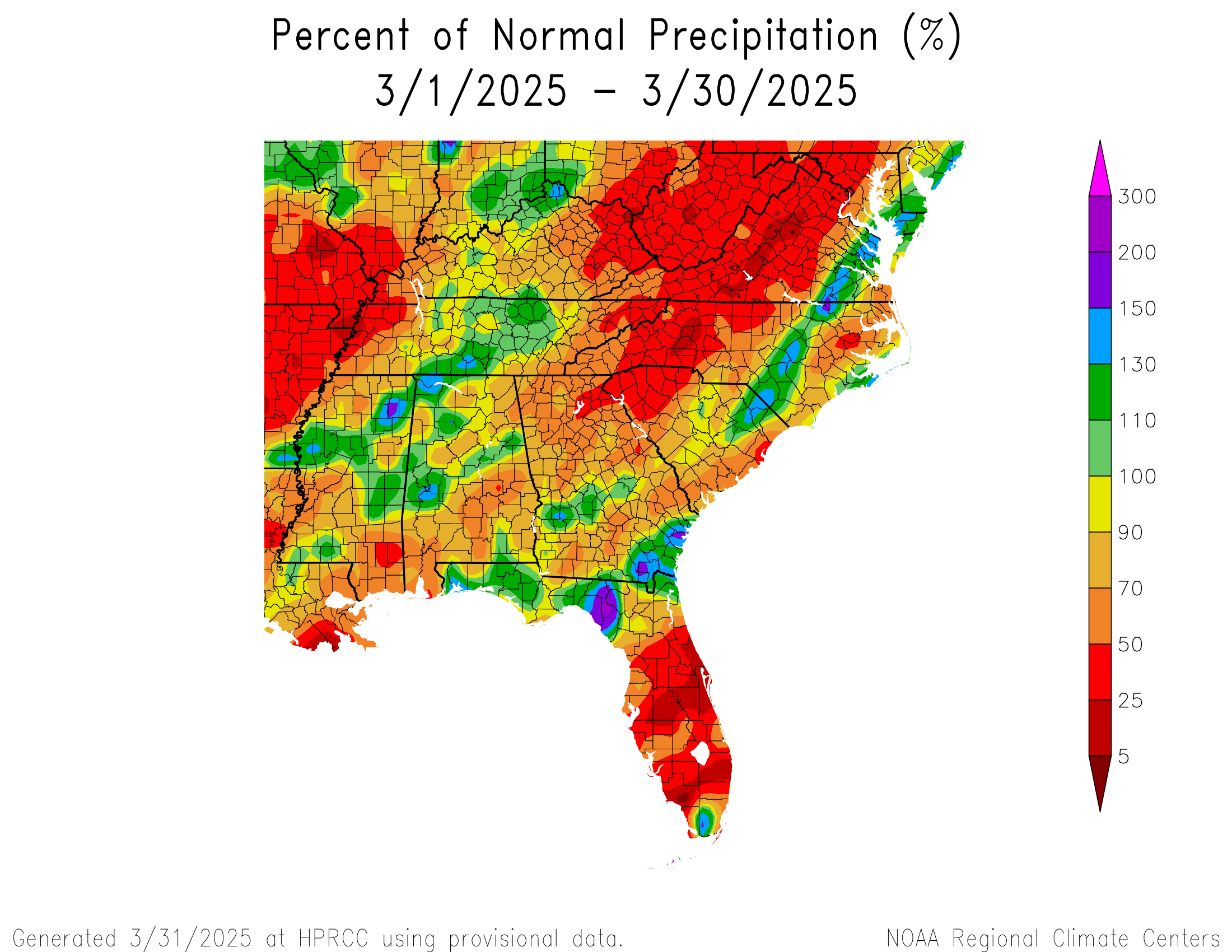
You can see that most of Kentucky has been slightly below average, with much drier conditions to the west into Arkansas and Missouri. Yesterday’s rainfall is missing from here, but in general, the theme has been at or slightly below average since early March.
It’s been another story in 2025 as a whole. We had terrible flooding in Kentucky earlier this year. Soils still haven’t entirely recovered from the wet start to the year, and you can see it in soil moisture readings today.
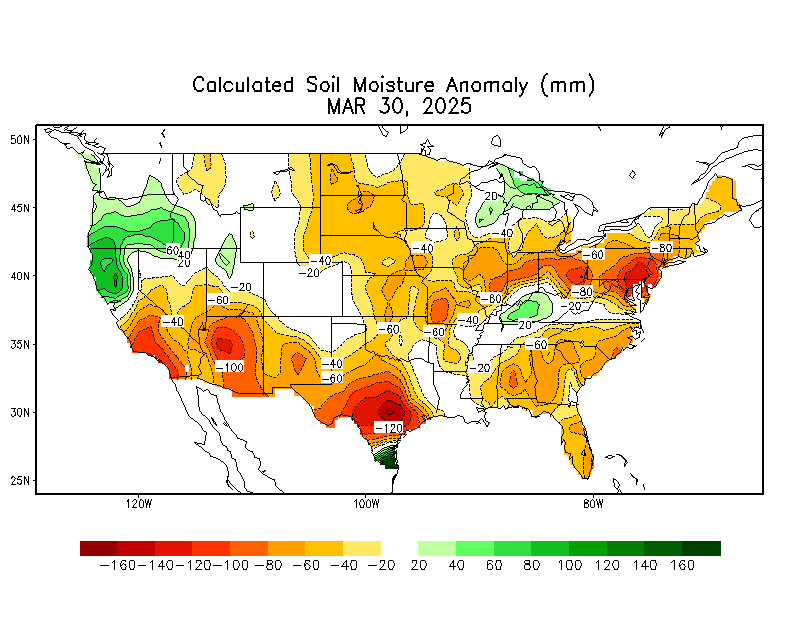
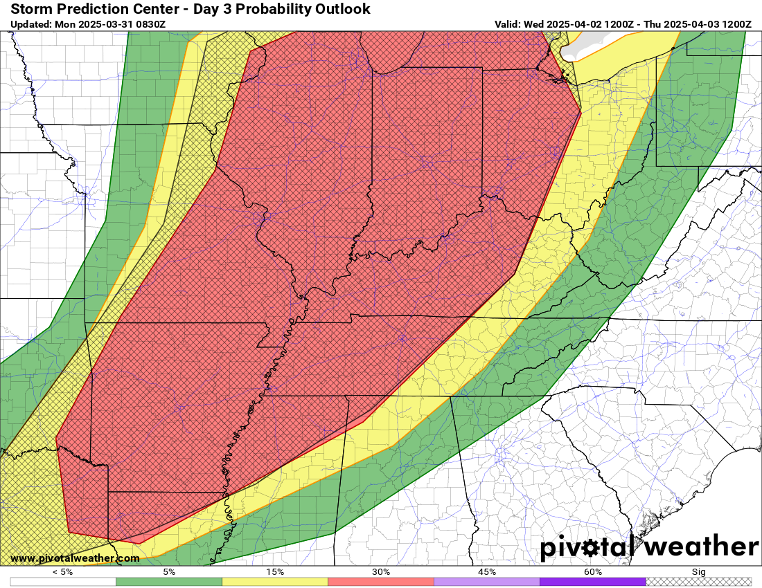
So, we look at the antecedent conditions ahead of a heavy rain event to get a sense of how much water can be absorbed initially. And the answer here is, “some but not that much.” Unfortunately, it’s not just one round of rain we’re expecting in the Ohio and Mississippi Valleys but rather several rounds between Wednesday and Saturday. Yes, there is a notable severe weather risk. But the flooding risk needs to be stressed a lot.
Not only is it significant, but it’s also potentially historic. Below is a table of the 5-day rainfall forecast from Monday morning’s run of the NWS National Blend of Models (NBM) for some Mid-South and Ohio Valley cities, as compared to their 5-day record rainfall totals historically. Currently, both Paducah and Jonesboro are forecast to exceed their prior records, while Evansville and Dyersburg, TN are only an inch off records.
| Location | Forecast Wed-Sun | Standing 5-day rain record |
| Little Rock, AR | 9.5″ | 12.9″ (1882) |
| Evansville, IN | 9.8″ | 10.88″ (1910) |
| Dyersburg, TN | 9.9″ | 10.55″ (2016) |
| Cape Girardeau, MO | 10.4″ | 14.51″ (2011) |
| Jonesboro, AR | 10.8″ | 10.0″ (1937) |
| Paducah, KY | 11.0″ | 10.63″ (1983) |
So this is not just me saying it’s going to rain a lot.
The culprit is a cold front that is going to drop into the Midwest and Mid-South on Wednesday afternoon. As this happens, it’s going to run smack into a building ridge of high pressure over the Southeast that will be approaching all-time April records.
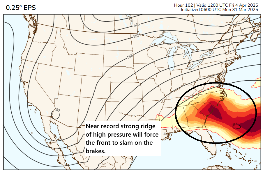
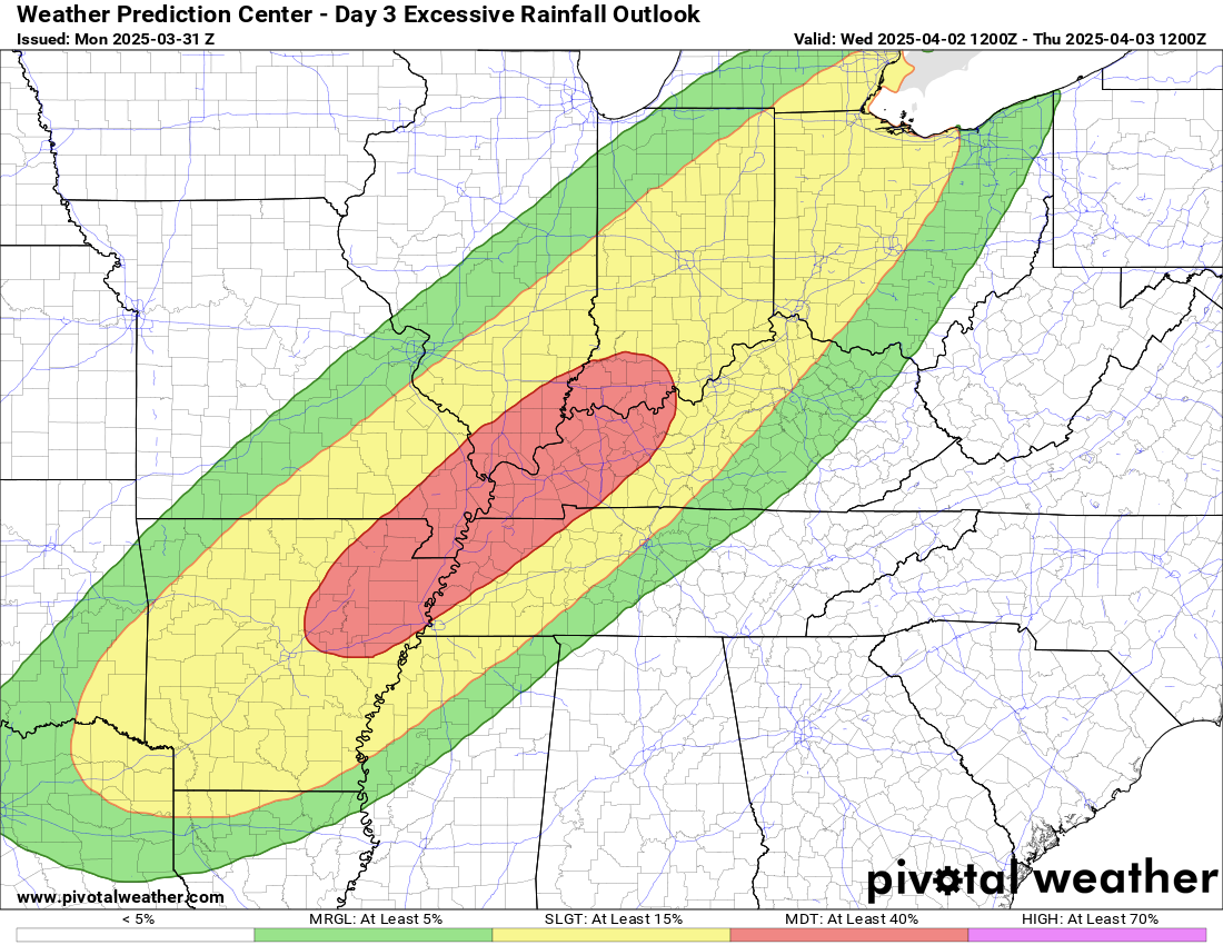
This will slow or halt the progression of the cold front, forcing it to stall out over the middle of the country, extending from roughly northeast Texas, across Arkansas and into the Ohio Valley. With a stalled front, and atmospheric moisture running very much above normal in this area, you have a recipe for a multi-round heavy rain event. The exact timing and specifics of each round are tough to pin down, but we know this much: There is a strong model signal for copious amounts of rain in the area between about Arkansas and Ohio. And the flooding risk is high enough to warrant three straight days of moderate excessive rainfall outlooks (level 3/4 Wednesday and 3/3 Thursday and Friday) from the WPC. I would expect at least one or two high risks to be issued when we approach later this week.
The day 4 and 5 moderate risks indicate pretty high confidence in significant flooding potential. I showed the forecast rainfall from the NBM above. That’s just one tool used, meant to show the potential for heavy rain. The current NWS Weather Prediction Center outlook for total rainfall shows a massive area of 8 to 10 inches of rain through the weekend.
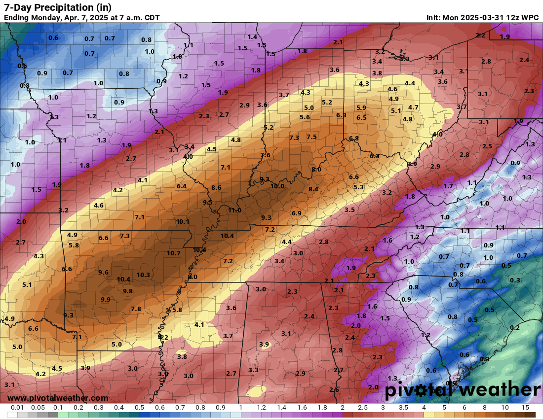
This is going to be a high impact, wide ranging, significant regional flood event. So how can this go wrong? Well, for one, you could see focused areas of rainfall embedded within the broader area, so we see some places forecast with 6 to 12 inches to see more like 2 to 4 inches with bullseyes of 10 inches or more. Much of this will depend on the strength of the Southeast ridge and where exactly the front stalls. For example, if the front ends up stalling farther north than anticipated, places like Dayton or Indianapolis or even St. Louis could see much higher rain totals, whereas if the front stalls farther south, Memphis, Nashville, or central Kentucky end up in the bullseye. That’s a shift that’s entirely within reason. So at this point while the general shape of the rainfall forecast should go unchanged, the exact placement of those bullseyes may waver some between now and Sunday.
And yes, in addition to the flooding, there is a significant severe weather risk, especially on Wednesday.
This risk is covered pretty heavily elsewhere. I’ll point you in particular to my friend Alan Gerard’s Substack, which will go in depth on all these threats in the days ahead.
I can remember Baton Rouge flooding because of excessive rains feeding into the Mississippi River, but can’t remember the details, or even what year. Is this a potential scenario this time around?
Always a possibility. But most river forecasts right now only take into account about 48 hours of rainfall, so we’re still a bit of a ways out from seeing what the upstream responses will be. That can help to gauge what things will happen downstream.
💫😶💫
Brutal weather.
Getting to be a whiskey & rowboat scenario.
Frankly, I couldn’t care less about the Mississippi Valley and the Ohio river. I live in Texas. What happened to the local forecast I used to receive?
Were you born a prick? Go create your own forecast if you don’t like it.
It’s at spacecityweather.com. This is The Eyewall, which focuses on places besides Houston, but is a companion site to SCW.