In brief: Tropical Storm Fernand is heading out to sea, not a threat. Invest 99L is heading into the Caribbean, unlikely to develop. Heavy rains are likely this week in the Southern Plains and parts of the Southern Rockies, with flash flooding risks. Wildfires are an issue out West, and while cool weather will dominate the country this week, additional heat and fire risk will bubble up in Oregon, Washington, and British Columbia.
Today’s post will take a look at the tropics, the main storylines for the upcoming week, and some wildfire updates.
Tropical Update
Tropical Storm Fernand
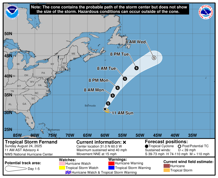
Starting off Sunday southeast of Bermuda, where Tropical Storm Fernand is churning. While Fernand has, at times, looked pretty decent this morning and afternoon, it generally seems to be struggling overall. It’s a modest tropical storm at best, and the good news is that it’s heading out to sea. This will be its closest pass to Bermuda, so no real impacts are anticipated.
As Fernand exits off to the north and northeast, it could see a quick burst of some organization, trying to drive it up to stronger tropical storm intensity. But for the most part, Fernand will be a footnote in the 2025 Atlantic hurricane season.
Invest 99L
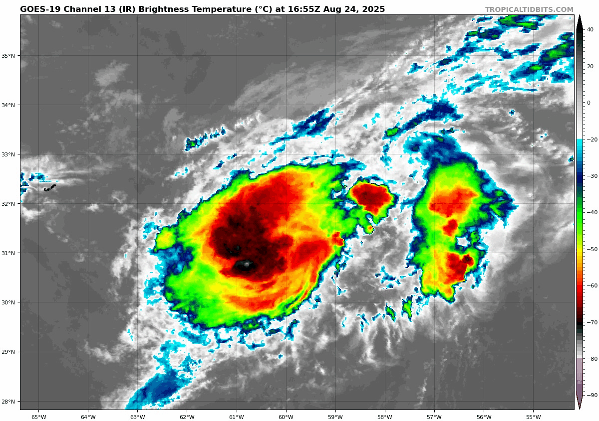
To the south of Fernand, Invest 99L continues to confound and defy model projections of dissipation.

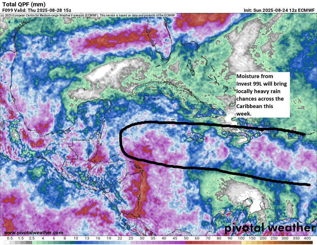
It still looks robust, but despite the persistent thunderstorm activity, 99L has never been able to get itself together. This is a disturbance that in another timeline would be a major hurricane bearing down on the islands. Thankfully, it is not, and over the next couple days, Invest 99L will face its harshest environment yet. Wind shear and some dry air will push at this system, likely keeping no worse than it is at present. It will deliver above normal moisture and thunderstorm chances across the central Caribbean, perhaps up through Jamaica and eventually into Central America.
Development seems unlikely, but this is probably worth checking back in on in a couple days to make sure.
Next 7 days in the Atlantic
Beyond these two specific systems, it’s hard to really tell what might be next to watch. With a cool front draped from the Gulf, across Florida, and into the southwest Atlantic, that seems like the most typical type of setup we’d expect to see a chance for something to sneak under the radar. I wouldn’t be shocked to see an area of interest drawn in that region, probably in the 10 to 30 percent range in a day or two. But aside from that, we have no other specific threats or concerns we’re seeing out there for the next 7 to 10 days. We talked a bit about that yesterday if you want to read more.
Southern Plains & Rockies flooding risk this week
Bringing things back to terra firma, it’s going to be a busy week in the Central U.S. in terms of flooding risk. The outlook over the next 5 days, including the rest of today calls for meandering slight risks (2/4) of flash flooding across the Southern Rockies in Colorado and New Mexico and the Plains.
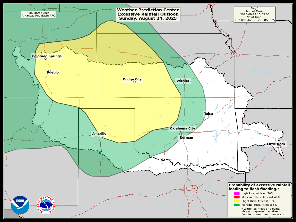
The rain chances look most significant tonight from western Kansas into northwestern Oklahoma. Tomorrow, the rain chances really pick up in eastern Oklahoma, particularly closer to the Tulsa area and northwest Arkansas. Isolated areas will likely see 3 to 4 inches or even a bit more from tomorrow’s storms. The heaviest rain chances will likely shift back west into the Rockies on Tuesday into Wednesday morning. Another round of potentially significant rain and thunderstorms will be possible in Oklahoma into northwest Arkansas on Thursday.
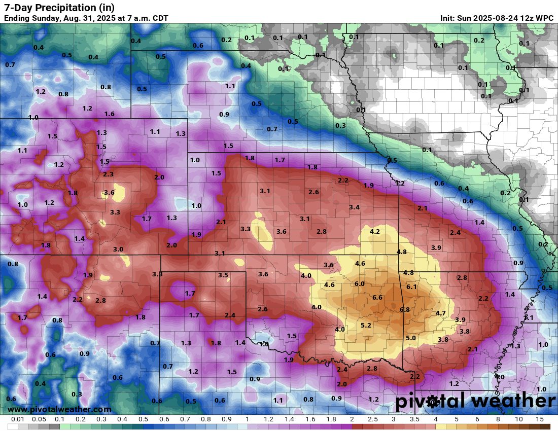
The current rainfall forecast calls for 2 to 4 inches this week over a wide areas between the Rockies and Ozarks, with the peak totals occurring near Tulsa or Fayetteville up to 6 to 8 inches. Flash flooding will almost certainly become an issue at times in these areas this week. Locally heavy rains in the Southwest will probably cause some flash flooding in southern Colorado or northern New Mexico. Burn scars will be susceptible to that, particularly in New Mexico, thankfully mostly north of the Ruidoso area, though still in portions of the state. Localized severe thunderstorms are possible as well.
Wildfires
Meanwhile, in Oregon, the Flat Fire has grown to over 20,000 acres, with 1,000 homes under evacuation orders and another 3,000 in potential evacuation zones. Additional wildfires were causing issues in the West, including the Pickett Fire in Napa Valley. Meanwhile, the fire risk we’ve been discussing in Atlantic Canada is materializing in Nova Scotia, where strong winds are hampering efforts to contain the Long Lake fire in Annapolis County. This one seems to be thorniest of the several ongoing fires that preceded Hurricane Erin’s passing this weekend. Thankfully, some rain is forecast, but with drought as severe as exists in this area, much more will be needed.
Chilly? weather
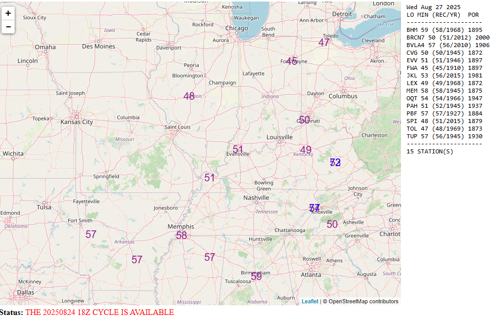
The other big story this week will be the autumn preview, also known in virtually every state’s seasons meme as “False fall.” Yes, much of the country will experience cool temperatures this week, with a number of record lows even possible in parts of the Midwest and Mid-South around midweek!
This cooler pattern is beginning to look like it wants to sit around for a bit. Although it will moderate some, any real hot weather will be confined to the extremes of the country this week, primarily in the Pacific Northwest and up into British Columbia. Wildfire risk is likely to increase in those areas through the week, as persistent hot and dry weather continues, along with the potential for dry lightning.