In brief: The Eastern Pacific is off to the races with 2 storms and a third possible by the weekend. None are serious land threats. The Atlantic is quiet this week but may have a window for weak development next week. And Texas is going to see the rains move in this week too.
Pacific is up and running
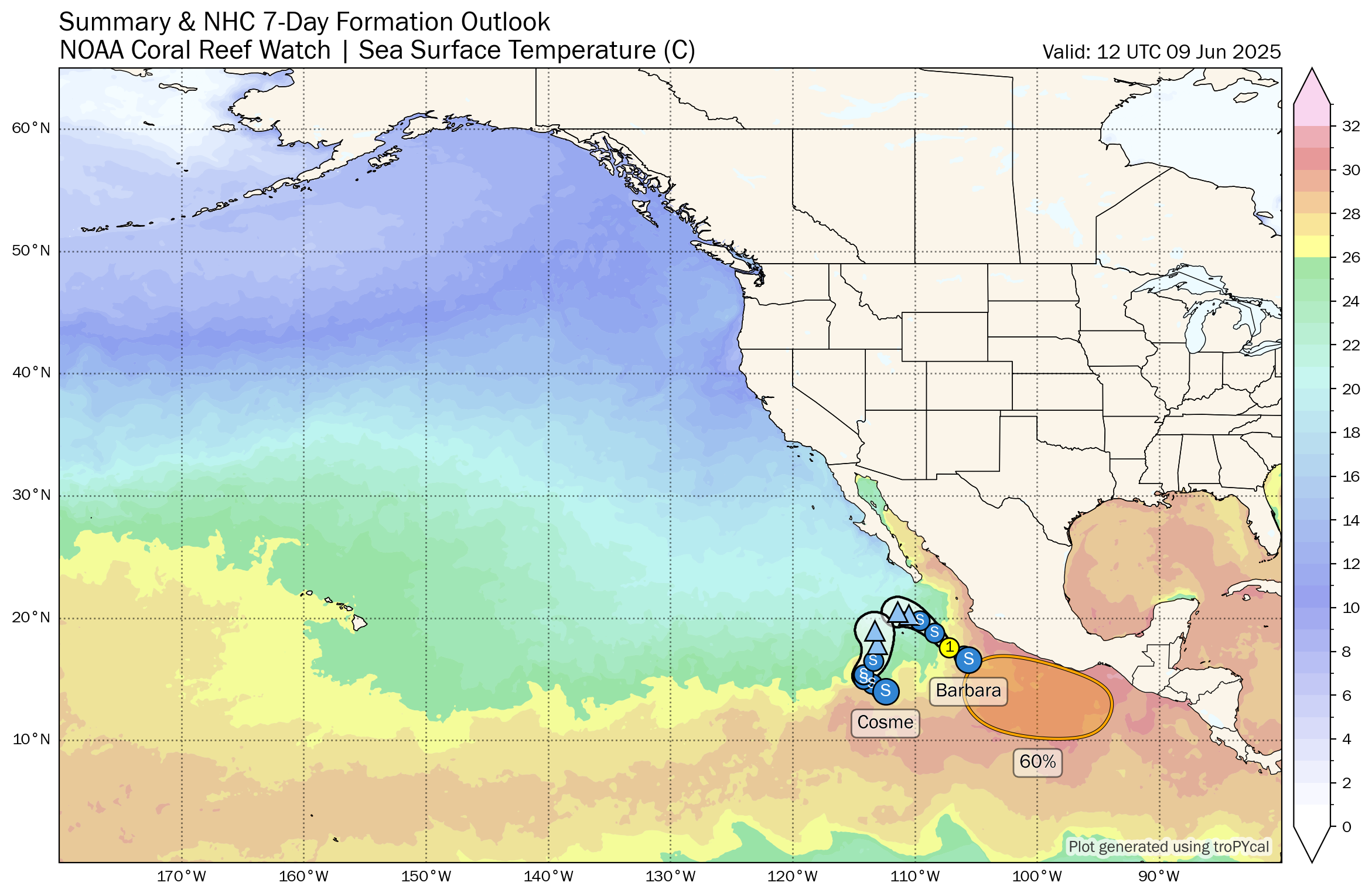
We’re up to named storm number three in the Eastern Pacific after Barbara and Cosme formed this weekend. Neither will be a real threat to land, though Barbara is producing some locally heavy rain on the Mexico coast, particularly in Guerrero. But Barbara could become a hurricane on the way out into the open Pacific. It may also absorb Cosme. Trailing these two is another disturbance to watch late this week. While this one should also generally follow Barbara and Cosme out to sea, it’s still worth watching for coastal Mexico between Jalisco and Oaxaca.
Atlantic stays dormant a bit longer
Meanwhile, the Atlantic will remain on the quiet side this week. No tropical development is expected before the weekend.
I do think we have our first legitimate sign of possible development showing up, however. Emphasis on possible. The window is next week. The GFS, of course, continues to show something. More reliable model guidance is more mixed. The ICON, European, and Euro AI modeling all show hints of something in the Bay of Campeche around next Wednesday or Thursday. Ensemble guidance is fairly muted. All this to say, that it seems whatever may have a chance to develop next week has a relatively low ceiling at this point (think invest or depression more than a named storm).
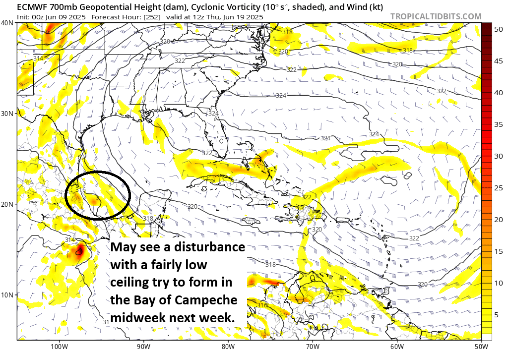
Bottom line: I would say that overall, there is a greater chance that nothing organizes than something does. And if something does, the main concern would be heavy rain and flooding, most likely in Mexico. I don’t want to diminish the flooding chances, but I also don’t want people to think a hurricane is forming in the Gulf next week, as that’s not a realistic outcome at this time. Plenty of time to consume model runs this week and see if anything changes.
Major pattern change in Texas
One other item to note is that after a pretty hot start to June (a top 10 hottest in Houston, San Antonio, and Austin), the rains return this week. In fact, some locally heavy rain is likely across interior Texas, a place that could certainly use some additional rainfall.
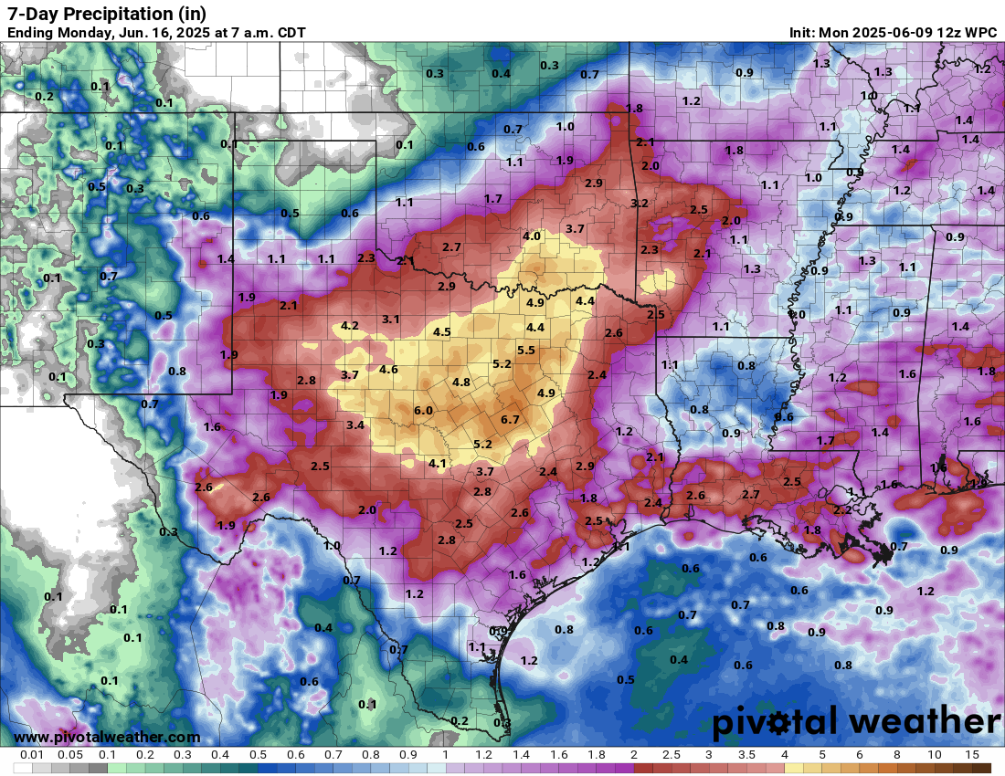
The heaviest, most concentrated rains this week look to occur in the DFW and Waco areas, as well as in the northern half of Hill Country. Parts of the Permian south-central Texas, and the Houston area will also see periods of rain and thunderstorms. Wednesday and Thursday may see the heaviest rainfall. This should keep heat in check in Texas this week as well.