Caribbean wave struggling but worthy of monitoring, while the surprisingly muted Atlantic plods forward

Headlines

  • A tropical wave in the Caribbean maintains about a 30 percent chance to develop in the coming days.
  • Model guidance doesn’t quite eliminate that wave as a potential area to monitor for the Bay of Campeche and/or Gulf, but very few models are bullish on intensity right now.
  • The rest of the Atlantic is rather quiet for September.
  • A potentially historic rain event in the Sahel and Sahara Desert may be symptomatic of bigger issues at play that could partially explain some of this season’s failure to launch.

Caribbean wave continues to lurk

The number of forecast consensus iterations on this Caribbean tropical wave over the last week or so have been rather annoying. Initially, we were discussing a system possibly heading out to sea. Then we started to discuss development farther west in the Caribbean followed by either a turn north or a continued track west. Then, even yesterday it looked like this was doomed to fail completely. And now today we have a new possible forecast wrinkle. In some ways, that’s “chasing” models, a practice that is not enjoyable, nor especially recommended. In other ways, I’m not sure what else you’re supposed to do with a struggling tropical wave that refuses to organize. It’s “guidance” for a reason, and in this case, the guidance has been shifting about.

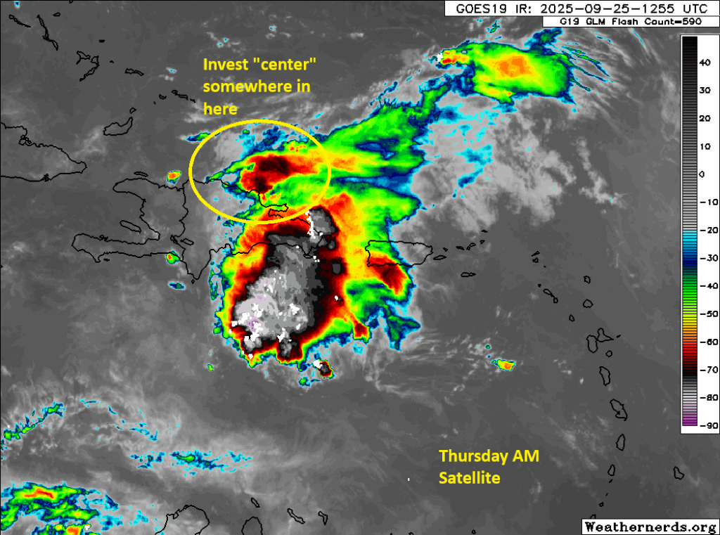
Anyway, end rant. here’s the Caribbean wave on satellite this afternoon.

A tropical wave in the central Caribbean is producing widespread thunderstorms across Hispaniola and points south and east of Jamaica. (Weathernerds.org)

I mean, that’s a respectable amount of thunderstorm activity. But there’s no organization to things here. At least not yet. That could change in the coming days but probably not before Friday. Admittedly, this system is a bit confounding in that it’s generally in a healthy environment to organize but thus far it is not doing so. It could be sinking air in the background suppressing things, it could the 20 to 25 mph forward speed of the system, or it could be proximity to Hispaniola that is currently holding it back. As this reaches the western Caribbean, it may have a slightly better opportunity to organize, albeit slowly. Expect this to be positioned off the east coast of the Yucatan or near Belize by Thursday night.

From there, we will embark on a choose your own adventure scenario with this. A trough over the Eastern U.S. will attempt to pull this system north — if the system can gain enough strength to do so. That seems unlikely at this time. Steering currents will sort of collapse as that trough pulls away, leaving the system in the Bay of Campeche or nearby just sort of wandering aimlessly.

An animation of the mid-levels of the atmosphere between day 5 (Sunday) and day 10 (Thursday) shows the ensemble mean with a signal for the tropical system in the Bay of Campeche, but a complete break-down in confidence on placement late. (Tropical Tidbits)

You can see that above with last night’s European ensemble modeling. The mean of the 51 ensemble members shows a good signal for some sort of disturbance in the Bay of Campeche by Sunday but then a gradual dissolution of the signal by next Thursday. This suggests that the system will meander in or around the Bay of Campeche, maybe even onshore in Mexico next week. From there, as the steering currents collapse, we could see some northward drift to the system, particularly if it begins to organize. So no one should be entirely ruling this out. But at this point, there are mostly a bunch of hypotheticals and no clear signal on potential track or impacts, except to say that most guidance is generally lower-end with this one, the exception being the ICON model and some AI modeling.

In fact, as of the latest NHC tropical weather outlook, development odds with this have dropped to 30 percent.

A trio of tawdry tropical waves across the Atlantic. (NOAA NHC)

The Atlantic remains calm, mostly

There are two other areas noted on the NHC outlook above. Neither one should impact land over the coming days. The trailing wave closest to Africa may have the better chance to develop, though admittedly the leading wave looks a little healthier at the moment.

Bless the rains (up?) in Africa

But there are weird things happening right now, and we’ll certainly get into them in the days ahead. For one, tropical waves may again emerge too far north off Africa to really produce much in the way of development. In fact, if you look at the forecast rainfall as a percent of normal in Africa over the next 2 weeks, it very clearly shows that portions of the Sahel and even the Sahara Desert are expected to get more than their fair share of rainfall.

Rainfall over the next 2 weeks looks to be on the order of 750 percent of normal in northwest Africa, a truly extraordinary rain event in one of Earth’s driest locations. (StormVista)

This is truly odd. And possibly historic. Now, the amount of rain that can produce 500 to 750 percent of normal rainfall in those areas is probably a lot less than you’d expect. When your average precipitation totals are miniscule, well it doesn’t take much. But still, it’s impressive. There was a decent write-up about this from a site over in Europe that I think touches on some of what’s happening here, key among it: The inter-tropical convergence zone (ITCZ) is displaced just enough farther north than normal to have a strong impact on what we see in the Atlantic. Everything is connected in some way, and it’s plausible that such an outlier event is in some way related to the extreme, historic warmth of the Atlantic Ocean right now. I don’t want to overshoot my skis here, as this is not a topic I’m overly familiar with. But it will merit research and further analysis.

Some of the seeds of that research have been done already, with a recent paper led by author Dr. Kelly Nuñez Ocasio from Texas A&M. Their work suggests that more moisture in the atmosphere as both the oceans and atmosphere warm with climate change can lead to a shift in tropical wave coupling with thunderstorms. In other words, you would get something like we see now, with more waves and storms to the north, and less robust waves emerging off Africa in the places we expect to see them in September. It’s a fascinating study, and given that the paper was published in June, it could not be more timely.

Is this what we’re seeing? Maybe. There’s a theory that supports it, but you obviously can’t prove anything based on one event in one season. But given that we’re probably about to hear a whole lot of people screaming “bust” at the top of their lungs with respect to this hurricane season, it makes for a provocative possible explanation, among other things we’ve touched on.

Tropical wave bound for the Caribbean in no hurry to put itself together

Headlines

  • Model support for tropical development in the Caribbean has fallen off a bit since yesterday, but the wave that moves through there next week does still bear watching.
  • Low pressure in the Gulf of Mexico continues to serve up locally heavy rain on the Texas coast, where totals are approaching 10 inches or more.
  • Additional rain or localized flooding is likely through the week, shifting south a bit toward Corpus Christi as the week progresses. Tropical development, if any, would be slow and still on the lower end of intensity.

The little Caribbean wave that may or may not

Something funny has happened with hurricane season this year. Storms early on tended to outperform model expectations. Systems since mid-August that have shown in modeling are tending to look more lackluster longer. And indeed, the tropical wave we’ve been discussing that will pass through the Caribbean this week is following that pattern. Yesterday, the National Hurricane Center boosted development odds to 50 percent, only to back it down later to 40 percent. We’re still there today, but model trends in the last 24 hours have pulled back even more.

Tropical development probabilities are hovering around 40 percent with the tropical wave that will emerge in the Caribbean this week, and that may even be a bit generous. (NOAA NHC)

On satellite, this tropical wave remains nothing impressive. Yes, it has thunderstorms with it, and there will definitely be some heavy rain moving into the Lesser Antilles early this week, but any development is non-existent at this point.

The tropical wave just east of the Lesser Antilles remains poorly organized this afternoon. (Weathernerds.org)

And, look, that’s what we expected. We’ve been saying most of the last week that this was not going to be quick to develop, and so far that seems to be playing out. Yesterday we noted the inflection point that this system would hit in the western Caribbean when the atmosphere got a little less hostile to tropical development. We also noted that there was a distinct split in the European model ensembles with a bunch staying weak and going west toward Mexico or Central America and some that strengthened and turned northward. Indeed that continues today, but if the split was 60/40 yesterday, it’s 80/20 or even 90/10 today!

European ensemble members strongly support a weaker, more south and west track of the Caribbean wave after next weekend. There are a still a handful of stronger, farther north outcomes, but trends in the last 24 hours have been to back down on those. (StormVista)

The first thing many of you will say is “Oh, you said Beryl was supposed to do that too and look what happened!” That’s an understandable reaction. The difference this time around is 1.) this system is in no hurry to develop whereas Beryl was a Category 5 hurricane in the Caribbean, 2.) there is no real model support from models like the ICON or AIFS (AI version of the Euro) or even the GFS, and 3.) We have a cold front sitting off the Gulf Coast as this one approaches the western Caribbean. So this is a fundamentally different setup than in Beryl. We are going to continue to keep tabs on this obviously, but the message since yesterday has been to back down somewhat on development odds. There’s just something hindering development in the Atlantic basin right now. I think we continue to see generally sinking air in the western Atlantic in the background and overall more stability in the atmosphere than had been expected this season. This may now continue into mid-September.

Texas coast tallying nearly double digit rains

We’ve seen an additional 3 to 5 inches of rain since yesterday between Baytown, just east of Houston down to the Bolivar Peninsula and out to about High Island, bringing totals since Thursday up to about 6 to 12 inches of rain along the coast and just inland for portions of Texas. The highest officially measured total I’ve seen is 9.17″ at JB’s Seafood in Crystal Beach, where I believe Jefferson County has a gauge.

Radar estimates of rainfall since Thursday show 7 to 11 inches over a good portion of coastal Texas between the Bolivar Peninsula and Sabine Pass. (RadarScope)

Overall, models snuffed this one out well, though they were a bit overzealous inland. In the meantime, surface low pressure continues swirling today about 50 to 75 miles southeast of Galveston. It remains very disorganized.

A late morning surface analysis shows low pressure sitting off the Texas coast. It remains weak and disorganized. (NOAA WPC)

The low is expected to continue drifting offshore of Galveston for a few more days. It may eventually trend southward with time, closer to Corpus Christi. All the while there will remain a low chance it develops a little. But rapid intensification or strong organization is not expected with this system. Rainfall over the next 5 days looks to be on the order of 3 to 6 inches between Corpus Christi and Sabine Pass, with locally higher and lower amounts. A localized flash flooding risk remains very much in play for these areas.

Anywhere from 3 to 6 inches of additional rain is possible on the Texas coast between Corpus Christi and Sabine Pass over the next few days. (Pivotal Weather)

Thankfully, the rain has mostly been coming at a pace that is manageable. It’s just adding up in these locations over time. And that can lead to localized flooding eventually. For Houston, Beaumont, and Lake Charles, this is mostly a non-event with just passing showers or storms in the cards over the next several days. The stalled front in interior Texas may focus rainfall through the week in drier parts of the state.

Elsewhere, no tropical development of note is expected, and certainly no land impacts are expected over the next week.

Odds of Caribbean development inch up next week with few details available at this point

Headlines

  • Tropical development, while not likely in the Gulf cannot be entirely ruled out as heavy rain will continue to pile up for portions of coastal Texas and Louisiana.
  • The next wave in the Atlantic remains unlikely to develop til it gets to the Caribbean.
  • From there, we have a lot of questions and very few answers, but it bears watching, particularly for the Gulf and Caribbean.
  • Farther out in the Atlantic, we have some waves to watch, but none looks to be a concern at this time.

Gulf of Mexico: Low development odds, coastal soaking underway

We continue to see low pressure meandering around the northwest Gulf today. As of this morning, it was centered right along the coast near High Island, TX. Heavy rain was funneling in through Sabine Pass and Port Arthur. So far this week, portions of coastal Jefferson County, TX have seen about 7 inches of rain or more. And there are even hints on radar of 8 to 10 inches just east of Sabine Pass and across coastal Cameron Parish in Louisiana.

Heavy rain continues to pound coastal areas east of Houston, with as much as 8 to 10 inches of rain between Sabine Pass and Cameron. (NOAA MRMS)

Over the next few days, we’ll continue to see this low mosey about in the Gulf or along the coast. The proximity to land is one reason significant development is unlikely from this over the weekend. This will probably continue to trek back and forth between Matagorda Bay and Cameron Parish through Wednesday or Thursday before eventually kicking off to the east or northeast with an approaching cool front.

With tropical development possible but not especially likely, the main issue with this will continue to be locally heavy rainfall. Through Tuesday morning, we could easily see another 2 to 5 inches of rain, with higher amounts possible in coastal areas.

Heavy rain will continue to pelt coastal parts of Texas and Louisiana at times through Monday and Tuesday. (Pivotal Weather)

Inland areas, such as in Houston are likely to see some showers, drizzle, or rain but nothing serious. Flash flooding and street flooding are growing possibilities between Galveston and Cameron, with the Sabine Pass through Port Arthur areas probably the most susceptible at the moment. Flood watches remain hoisted east of this area for New Orleans and Baton Rouge as well. But the heaviest rains will fall closer to the Texas/Louisiana state line.

Caribbean system: Far too early to do much other than watch

The wave that we’re going to watch in the Caribbean remains east of the islands this morning, a bit strung out and very poorly organized.

A tropical wave east of the Lesser Antilles is poorly organized at the moment, with any development expected to occur very slowly. (Weathernerds.org)

This one is in no hurry to develop. In fact, I would not be shocked to see this struggle over the next four to five days. The latest NHC outlook has bumped odds to 50 percent over the next week. A look at last night’s European model shows the system south of Hispaniola by Wednesday morning. It would be unlikely to be developed much at this point. Conditions in the eastern Caribbean are far from ideal for tropical development, so it seems as if this is going to struggle for a bit.

The tropical wave will move across the Caribbean and should be sluggish to develop through at least midweek. (Tropical Tidbits)

Once it gets past about this point, conditions for development will steadily improve, likely leading to strengthening and organization. To what extent and how far it gets in that process remains to be seen. By about next Saturday this system would probably be somewhere between Belize or western Cuba. A weaker system would be more apt to stay south and track into Mexico or Central America, whereas a more rapidly developing system would start to turn more northwest. But for the sake of simplicity this far out, let’s assume it’s somewhere in that bubble. If we look at a weather map next weekend, we can see a cold front rather far off the Gulf Coast. This is associated with a pretty deep trough over the East Coast.

A cold front and associated trough over the East Coast of the U.S. would likely “capture” any type of stronger storm and draw it more northward. (NOAA WPC)

Meteorologically, I would think that any sort of meaningfully strong tropical system would be captured by this trough and forced northward at some point. A system that doesn’t develop would probably keep tracking west. When I looked at the European ensemble this morning, I noticed this sort of bifurcated outcome, with one cluster going west and one turning north at varying points. It’s way too early to speculate on anything specific here, so I’ll leave it at that. Anything in the western Caribbean is of concern.

The ocean heat content anomaly is near or above record for this time of year in the Caribbean, an indicator of deep, rich, warm water in place for a storm to strengthen in. (Brian McNoldy)

The ocean heat content in the Caribbean is as strong as we’ve ever seen this time of year and prior to last year, the strongest we’ve ever seen. This is an indicator that there is a large reservoir of deep, warm water available for a tropical system to feast on. I often joke that the Caribbean is always supportive of big storms. This year, it’s supportive of big storms for longer.

We’ll continue to watch the positioning of the cold front. We’ll continue to watch the intensity of the trough. And hopefully we have a little bit more news to share on Monday or Tuesday. For now, continue monitoring this one, particularly in the Gulf and western Caribbean.

Next waves up

The next item on the docket is a tropical wave in the eastern Atlantic. This one has a low chance to develop over the next few days and would likely remain out to sea. The next wave emerging off Africa this weekend has perhaps a better shot to develop later next week in the eastern Atlantic. That too looks like it may remain out at sea.

One tropical wave is about to emerge off Africa. A slightly more robust wave is a few hundred miles east of there. These will emerge over the next 7 to 10 days. (EU METSAT)

Neither of these are a concern at the moment. Beyond that, we don’t have anything else of note to watch, which is good news.

Heading into the holiday weekend with more questions than answers in the Atlantic basin

Headlines

  • Sluggish tropical development is a low possibility in the northwest Gulf of Mexico as low pressure forms off the Texas and Louisiana coasts.
  • Though a serious system is not expected to develop, locally heavy rain and flash flooding are a good bet along the coasts of Texas and Louisiana into next week.
  • The Atlantic tropical wave continues to have mixed chances to develop, but the ceiling is high enough to continue watching closely.
  • An additional wave behind that one will probably stay out at sea, but conditions may continue to get more and more conducive to development as September progresses.

Gulf of Mexico

Let’s start closer to home first. We’ve been discussing it all week, but low pressure has now officially formed in the Gulf, with a surface low analyzed offshore of Galveston and Sabine Pass. The National Hurricane Center now highlights this area with a 20 percent chance of development.

A broad area of low pressure at the surface has formed off the Texas coast. Development is unlikely but could slowly occur in the coming days. (NOAA WPC)

The surface low is rather broad, so it’s not as if we have a rapidly intensifying tropical system off the coast. But we have low pressure in the Gulf, which is always something of note. Any development risk from this is very low-end in terms of winds and waves. But in terms of rain, this will be a source for some serious coastal rainfall in the coming days, development or no development. Rain totals through next week may tally up an additional 5 to 10 inches between Galveston and Vermilion Bay in Louisiana.

Localized flooding is a possibility on the coast of Texas and Louisiana into next week, with another 5 to 10 inches of rain likely through Wednesday. (Pivotal Weather)

While there are no flood watches posted currently (except in the New Orleans and Baton Rouge areas), there is some potential for flooding to occur in coastal counties and parishes. Places like Galveston, Port Arthur, and Cameron through Morgan City and New Orleans could definitely see at least localized street flooding crop up. With a surface low now offshore, most of the rain will likely consolidate around that feature, meaning that inland places like Houston and perhaps Lake Charles see less rain, less often.

Surface low pressure is broadly spinning offshore of Texas and Louisiana. Organization, if any, will be sluggish. (Weathernerds.org)

This will be a very coastal-focused feature. The low should meander in the days ahead offshore. Thankfully, upper level conditions aren’t super conducive for development, so again any organization or strengthening would probably be very sluggish and the ceiling from this is rather low it seems. As the low meanders, it could end up onshore in Louisiana or back toward the middle Texas coast, so proximity to land will also act against its development.

Rainfall along coastal Louisiana and back toward New Orleans will also be heavy in spots with localized flash flooding a concern here as well. (Pivotal Weather)

Bottom line: This is not a major concern, but it bears some watching and it will, at the least, deliver locally heavy rain and flash flooding potential on the Texas and Louisiana coasts.

Caribbean development chances

We continue to monitor a tropical wave in the Atlantic that has about a 40 percent chance of development as it moves into the Caribbean next week.

Tropical development should be slow from this wave as it moves into the Caribbean next week, but it does have enough potential to monitor for the northwest Caribbean and Gulf. (NOAA NHC)

To be clear out of the gate: We have no real good feel about the future of this system. It may not develop, or it could become a serious system to watch. We see legitimate arguments for both outcomes right now. We do know that there are a couple features to watch that will influence the outcome of this system. First, high pressure off Bermuda will help dictate steering flow for this, which is why we’ve seen the NHC outlooks gradually shift more and more to the south and west with time. Second, a cold front dropping into the northern Gulf of Mexico next weekend affiliated with an unusually deep trough of low pressure in the Eastern U.S. may also play a big role in this. Third, the intensity of the system itself will be important, as a stronger storm is more apt to turn north faster, whereas a weaker one will get farther west before turning.

What does it mean? It means we just need to continue watching.

The European ensemble probability of a tropical storm in the Caribbean next week and weekend is only around 20 to 30 percent right now. (Weather Bell)

The European ensemble and ICON model are generally the most bullish on development from this system. But even the ensemble can only muster about a 20 to 30 percent chance of development. There are a couple ensemble members that are very bullish on intensity with this. While they remain in the minority, that’s enough reason to keep watching. As we work through the holiday weekend, I am sure we will glean more information on this. For now, while frustrating, it’s prudent to acknowledge there is a great deal of uncertainty with this.

Beyond the Caribbean

Another system moving off Africa will have a chance to organize in the deep tropics but even that seems less than super exciting right now. It should hopefully end up out at sea as high pressure builds more to the west in the Atlantic, opening the exit door a bit in the east. We continue to see signs of an uptick in activity overall, and in fact, yesterday’s Euro weekly forecast for final full week of September is the first I’ve seen to show above normal storm intensity in some time.

The week 4 of the Euro weeklies yesterday shows above normal ACE for the final week of September, indicating that things will likely pick up as the month progresses. (ECMWF)

Based on this and some other data I’ve been looking at, I think September may play out interestingly. The first few systems we’ll probably see struggle to organize or struggle to get a handle on. The next batch will probably struggle to organize less, and then the final third of the month may be when the door barges open on an active period. A lot to watch in the weeks ahead, but fortunately still some time to keep tabs on things.