In brief: The Atlantic tropics are going to trend quieter, with Fernand heading out to sea and Invest 99L finally reaching the end of the road. Behind those? Not much. A significant typhoon hit Vietnam today. Flooding risks will continue in Oklahoma and Arkansas this week.
Tropics
We don’t have a heck of a lot to discuss today in the Atlantic! Tropical Storm Fernand continues to slowly work out to sea and away from Bermuda.
Fernand heads out to sea and should be absorbed into the broader weather pattern by later tomorrow or Wednesday. (NOAA NHC)
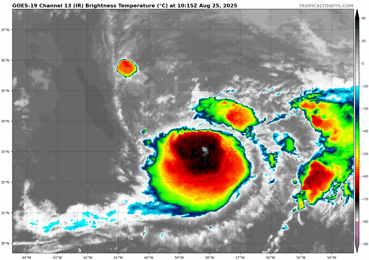
Fernand has strengthened a little since our post yesterday, as expected. However, it’s not exactly healthy. The center seems somewhat displaced to the north side of the thunderstorms, and it’s pretty evident that wind shear is beginning to really hamper Fernand.
Fernand is fighting wind shear and will soon have to fight cooler water too. (Tropical Tidbits)
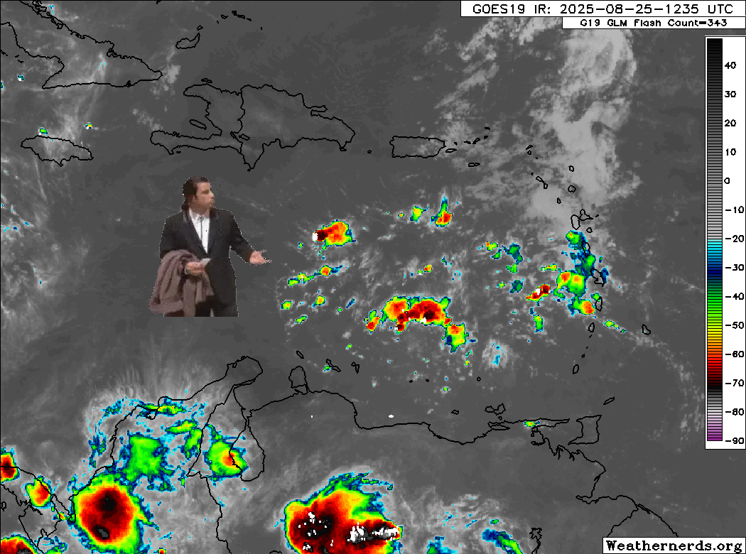
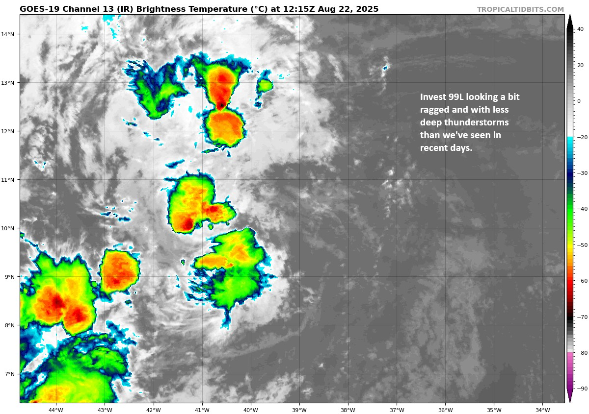
Meanwhile, to the south, Invest 99L has finally met its fate it would seem. Where did all the thunderstorms go?
(Weathernerds.org)
Thankfully, it just took some time but it got here. Look for the remnants of 99L to spread west across the Caribbean, bringing some scattered heavy rain and storms before eventually being buried in Central America or even South America as a small-scale feature. No development is expected, and this should probably close the book on this version of Invest 99L.
Beyond these areas, we see nothing of note in the Atlantic tropics for the next week, probably longer. A very rare and welcome late August and early September break seems to be in the offing this year. We will absolutely take that.
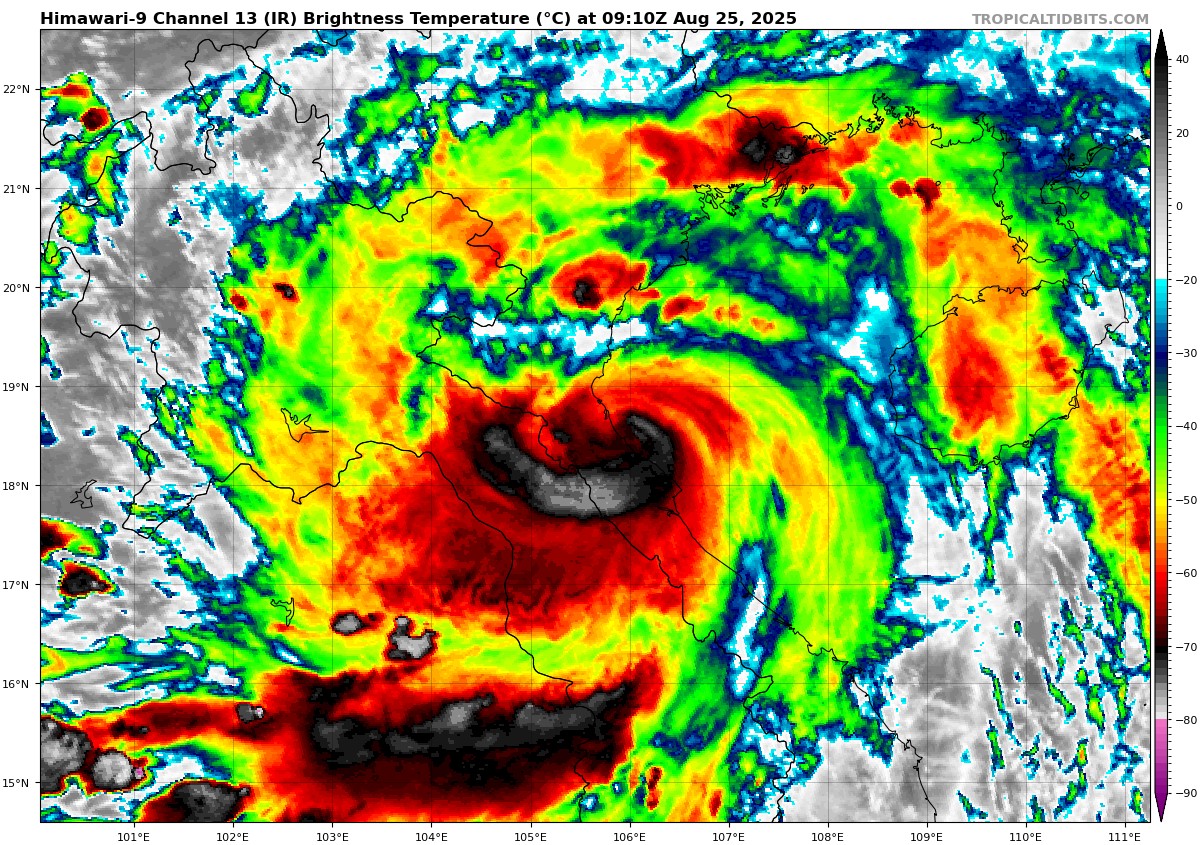
Typhoon Kajiki around the time it made landfall in Vietnam. (Tropical Tidbits)
In brief: Tropical Storm Fernand is heading out to sea, not a threat. Invest 99L is heading into the Caribbean, unlikely to develop. Heavy rains are likely this week in the Southern Plains and parts of the Southern Rockies, with flash flooding risks. Wildfires are an issue out West, and while cool weather will dominate the country this week, additional heat and fire risk will bubble up in Oregon, Washington, and British Columbia.
Today’s post will take a look at the tropics, the main storylines for the upcoming week, and some wildfire updates.
Tropical Update
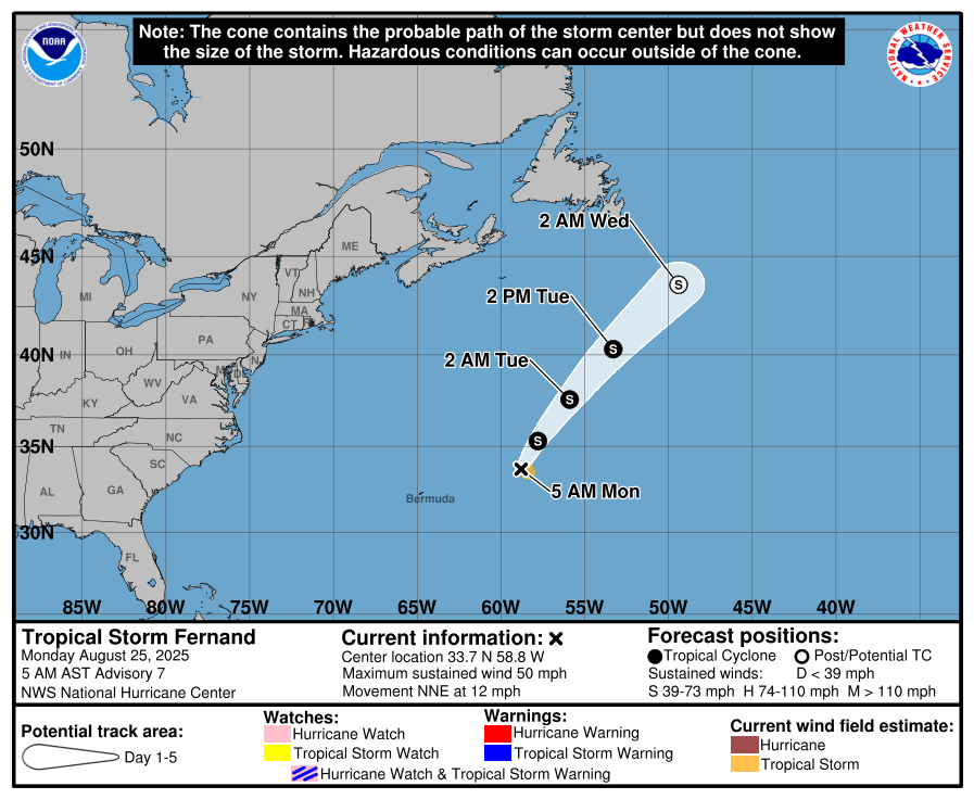
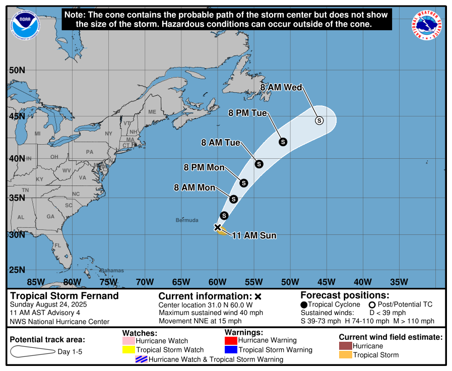
Tropical Storm Fernand
(NOAA/NHC)
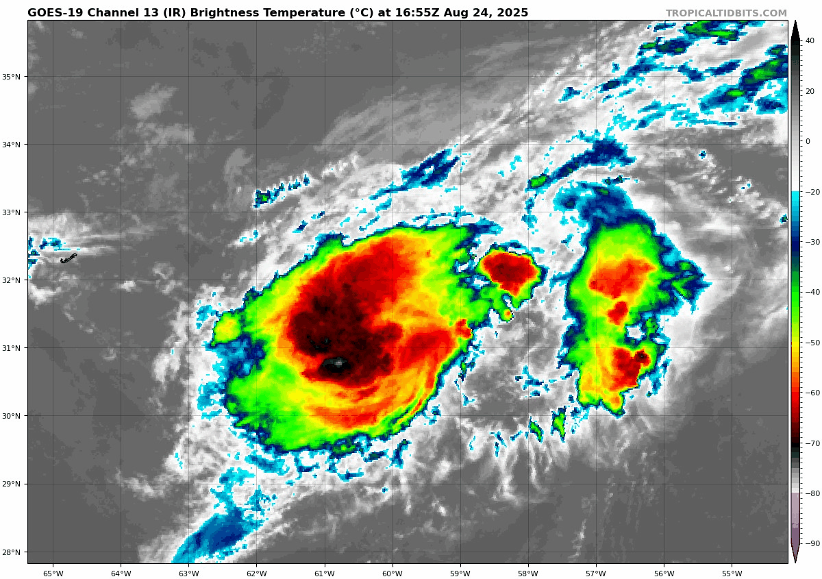
Starting off Sunday southeast of Bermuda, where Tropical Storm Fernand is churning. While Fernand has, at times, looked pretty decent this morning and afternoon, it generally seems to be struggling overall. It’s a modest tropical storm at best, and the good news is that it’s heading out to sea. This will be its closest pass to Bermuda, so no real impacts are anticipated.
Fernand looks like a true tropical storm, nothing more, nothing less. (Tropical Tidbits)
As Fernand exits off to the north and northeast, it could see a quick burst of some organization, trying to drive it up to stronger tropical storm intensity. But for the most part, Fernand will be a footnote in the 2025 Atlantic hurricane season.
Invest 99L
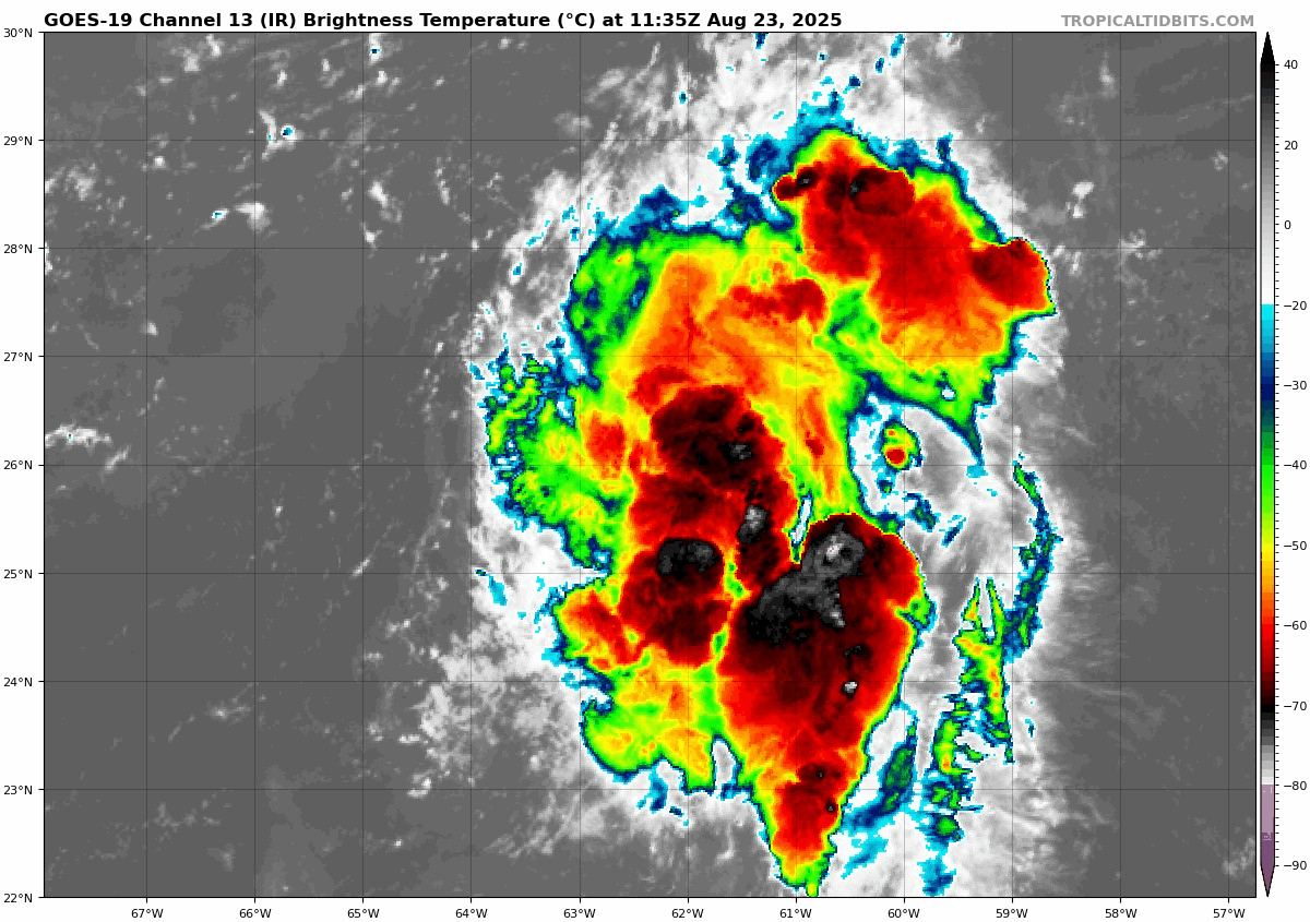
To the south of Fernand, Invest 99L continues to confound and defy model projections of dissipation.
Invest 99L is approaching the southern Leeward and northern Windward Islands on Sunday afternoon. (Weathernerds.org)
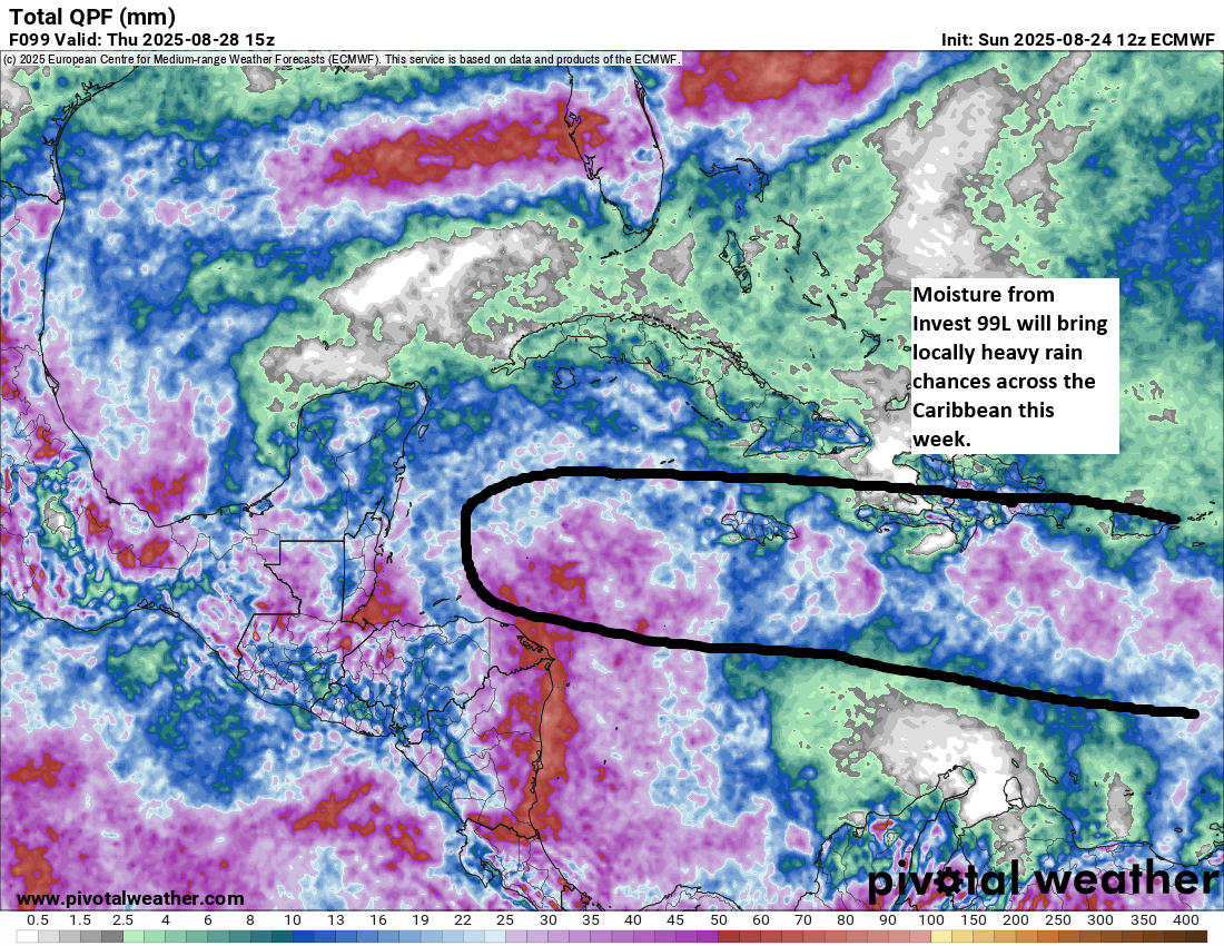
It still looks robust, but despite the persistent thunderstorm activity, 99L has never been able to get itself together. This is a disturbance that in another timeline would be a major hurricane bearing down on the islands. Thankfully, it is not, and over the next couple days, Invest 99L will face its harshest environment yet. Wind shear and some dry air will push at this system, likely keeping no worse than it is at present. It will deliver above normal moisture and thunderstorm chances across the central Caribbean, perhaps up through Jamaica and eventually into Central America.
Invest 99L’s moisture plume will bring some locally heavy rain chances this week across the Caribbean, including to Jamaica before it gets absorbed into the broader pattern over Central America. (Pivotal Weather)
Development seems unlikely, but this is probably worth checking back in on in a couple days to make sure.
Next 7 days in the Atlantic
Beyond these two specific systems, it’s hard to really tell what might be next to watch. With a cool front draped from the Gulf, across Florida, and into the southwest Atlantic, that seems like the most typical type of setup we’d expect to see a chance for something to sneak under the radar. I wouldn’t be shocked to see an area of interest drawn in that region, probably in the 10 to 30 percent range in a day or two. But aside from that, we have no other specific threats or concerns we’re seeing out there for the next 7 to 10 days. We talked a bit about that yesterday if you want to read more.
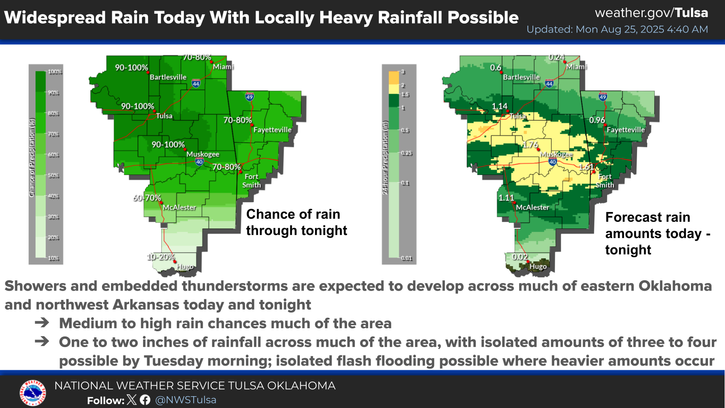
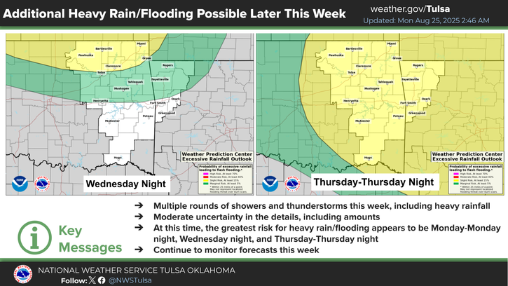
Southern Plains & Rockies flooding risk this week
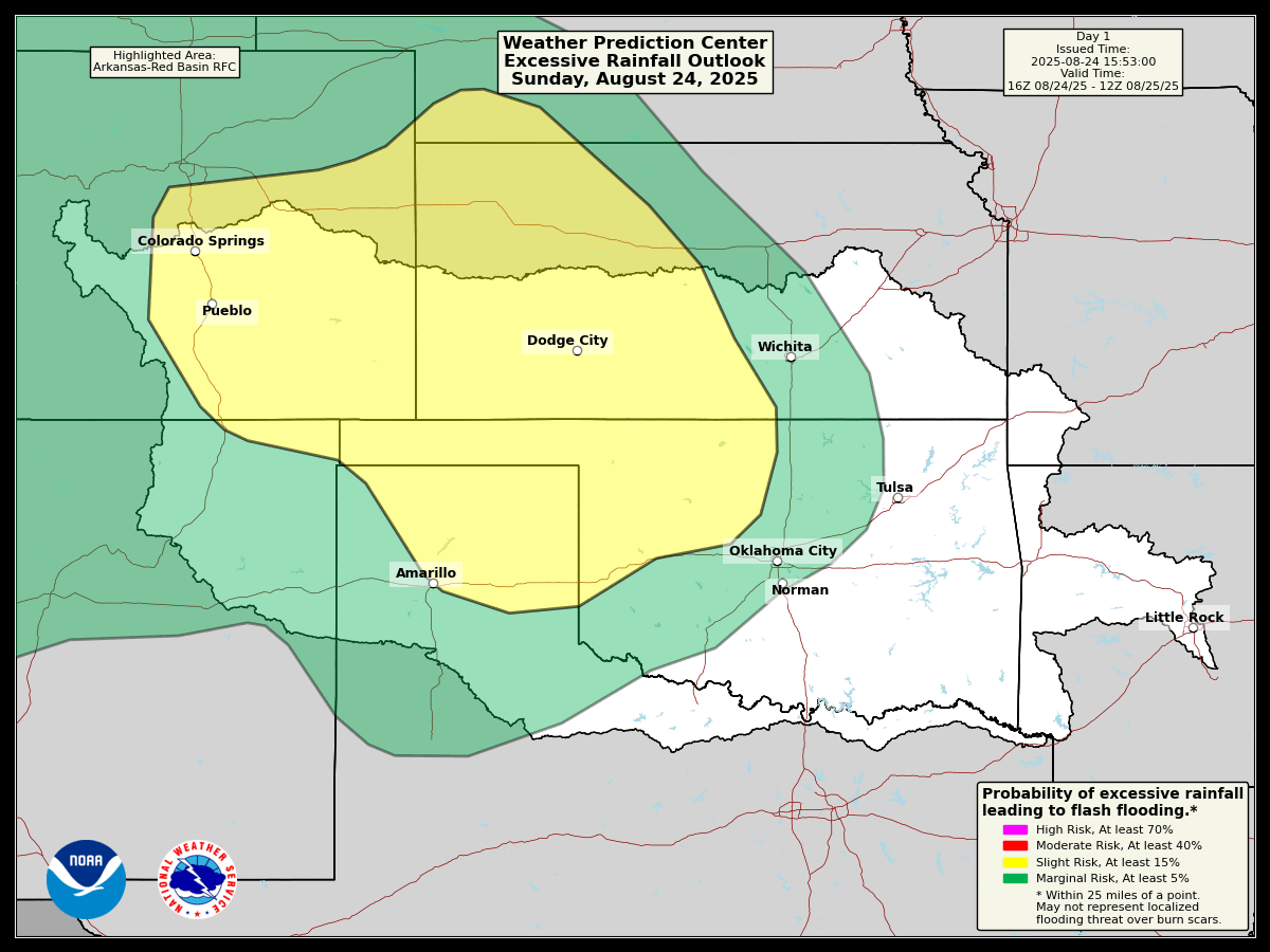
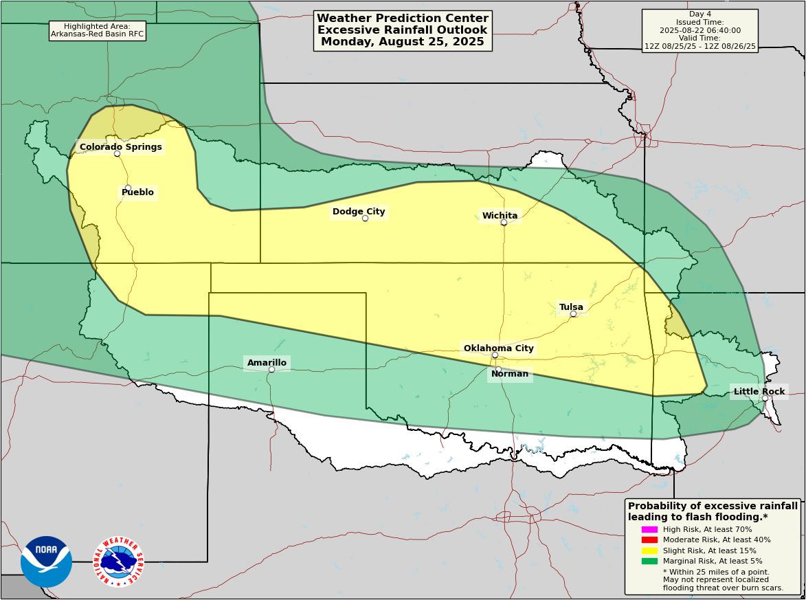
Bringing things back to terra firma, it’s going to be a busy week in the Central U.S. in terms of flooding risk. The outlook over the next 5 days, including the rest of today calls for meandering slight risks (2/4) of flash flooding across the Southern Rockies in Colorado and New Mexico and the Plains.
The slight risk of flooding (2/4 in yellow) maneuvers around the region between Sunday and Thursday. (NOAA WPC)
The rain chances look most significant tonight from western Kansas into northwestern Oklahoma. Tomorrow, the rain chances really pick up in eastern Oklahoma, particularly closer to the Tulsa area and northwest Arkansas. Isolated areas will likely see 3 to 4 inches or even a bit more from tomorrow’s storms. The heaviest rain chances will likely shift back west into the Rockies on Tuesday into Wednesday morning. Another round of potentially significant rain and thunderstorms will be possible in Oklahoma into northwest Arkansas on Thursday.
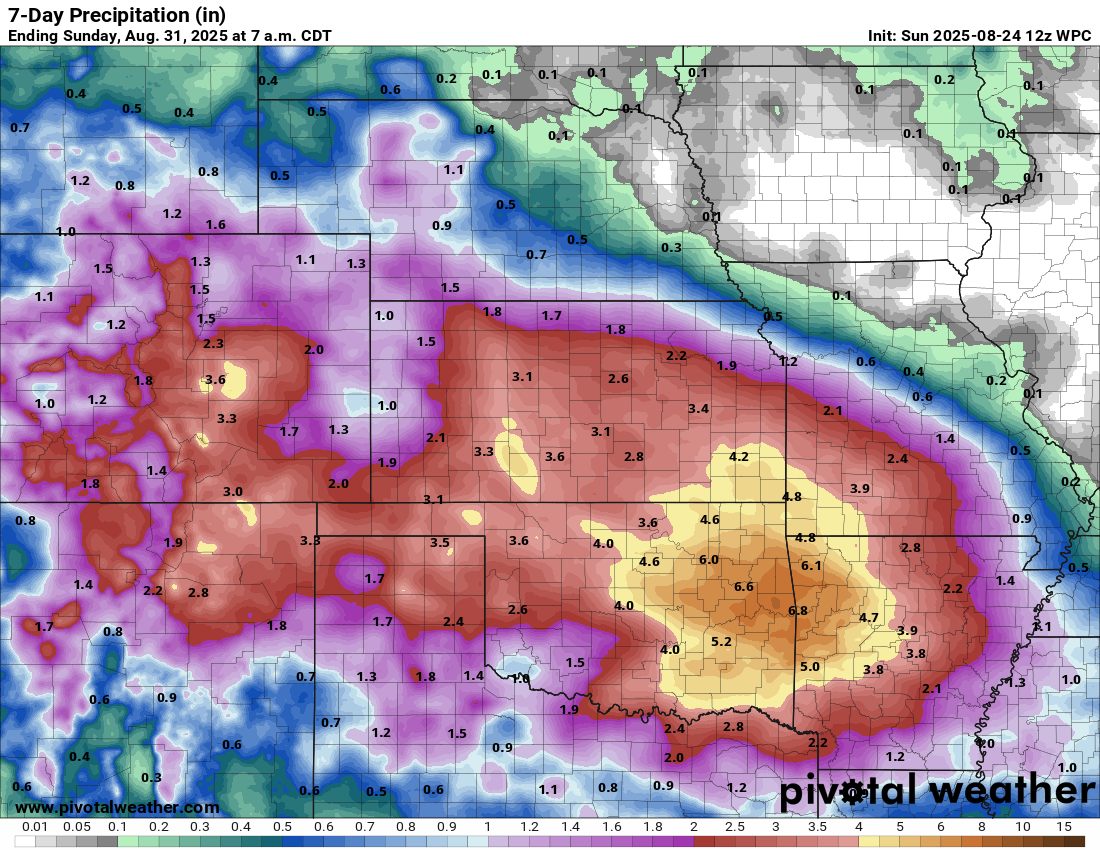
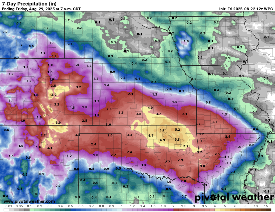
Significant rainfall is likely over the next week from the Front Range into the Ozarks, with the highest rain totals focused on Tulsa and Northwest Arkansas. (Pivotal Weather)
The current rainfall forecast calls for 2 to 4 inches this week over a wide areas between the Rockies and Ozarks, with the peak totals occurring near Tulsa or Fayetteville up to 6 to 8 inches. Flash flooding will almost certainly become an issue at times in these areas this week. Locally heavy rains in the Southwest will probably cause some flash flooding in southern Colorado or northern New Mexico. Burn scars will be susceptible to that, particularly in New Mexico, thankfully mostly north of the Ruidoso area, though still in portions of the state. Localized severe thunderstorms are possible as well.
Wildfires
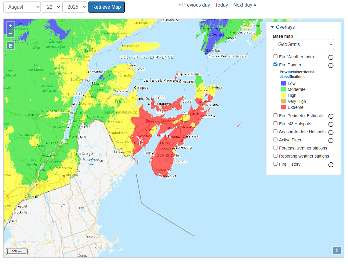
Meanwhile, in Oregon, the Flat Fire has grown to over 20,000 acres, with 1,000 homes under evacuation orders and another 3,000 in potential evacuation zones. Additional wildfires were causing issues in the West, including the Pickett Fire in Napa Valley. Meanwhile, the fire risk we’ve been discussing in Atlantic Canada is materializing in Nova Scotia, where strong winds are hampering efforts to contain the Long Lake fire in Annapolis County. This one seems to be thorniest of the several ongoing fires that preceded Hurricane Erin’s passing this weekend. Thankfully, some rain is forecast, but with drought as severe as exists in this area, much more will be needed.
Chilly? weather
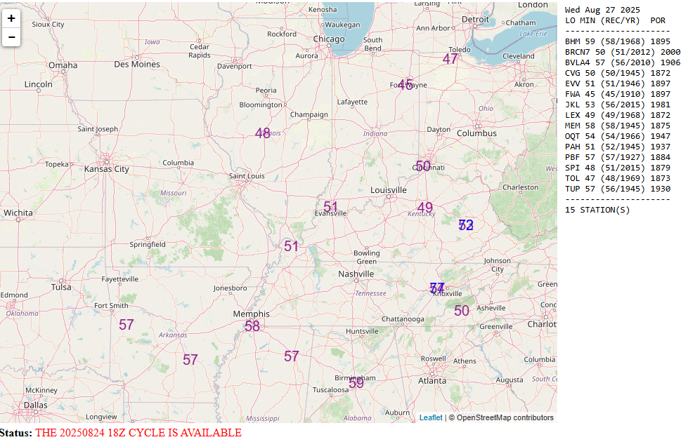
The other big story this week will be the autumn preview, also known in virtually every state’s seasons meme as “False fall.” Yes, much of the country will experience cool temperatures this week, with a number of record lows even possible in parts of the Midwest and Mid-South around midweek!
Potential record lows on Wednesday morning in the Midwest and Mid-South. (NOAA WPC)
This cooler pattern is beginning to look like it wants to sit around for a bit. Although it will moderate some, any real hot weather will be confined to the extremes of the country this week, primarily in the Pacific Northwest and up into British Columbia. Wildfire risk is likely to increase in those areas through the week, as persistent hot and dry weather continues, along with the potential for dry lightning.
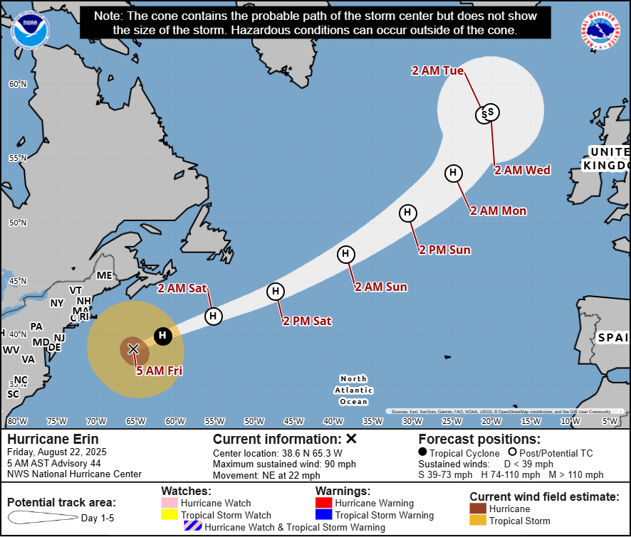
In brief: Hurricane Erin has transitioned to post-tropical, but it will still churn up waves, tidal flooding, and rip currents from the Mid-Atlantic into Atlantic Canada. An enhanced wildfire risk exists today and tomorrow from Maine into Atlantic Canada as well. Invest 99L is nothing to worry about. Invest 90L may broadbrush Bermuda tomorrow or early Monday as a tropical storm. But the tropics may be going into a calm period for a week or two after these systems.
Current state of the tropics
Let’s walk through our systems in the Atlantic to start today.
Hurricane Erin(post-tropical)
Erin has been deemed non-tropical now and would be considered an extratropical storm or post-tropical. The Canadian Hurricane Centre is still issuing forecast maps for Erin.
Erin’s post-tropical forecast track into tomorrow has it passing well south of Newfoundland. (Canadian Hurricane Centre)
Erin is accelerating out to sea now, passing well south of Newfoundland. Erin still has maximum sustained winds around 80 to 90 mph, however as it plows east-northeast. Again, post-tropical does not mean non-hazardous! Large waves will continue to generate outward from Erin, pounding the coast of Atlantic Canada, particularly along the south-facing coast of Newfoundland. High tides and tidal flooding are expected to continue from the Mid-Atlantic into New England as well, though those conditions will ease up some relative to where they were a day or so ago.
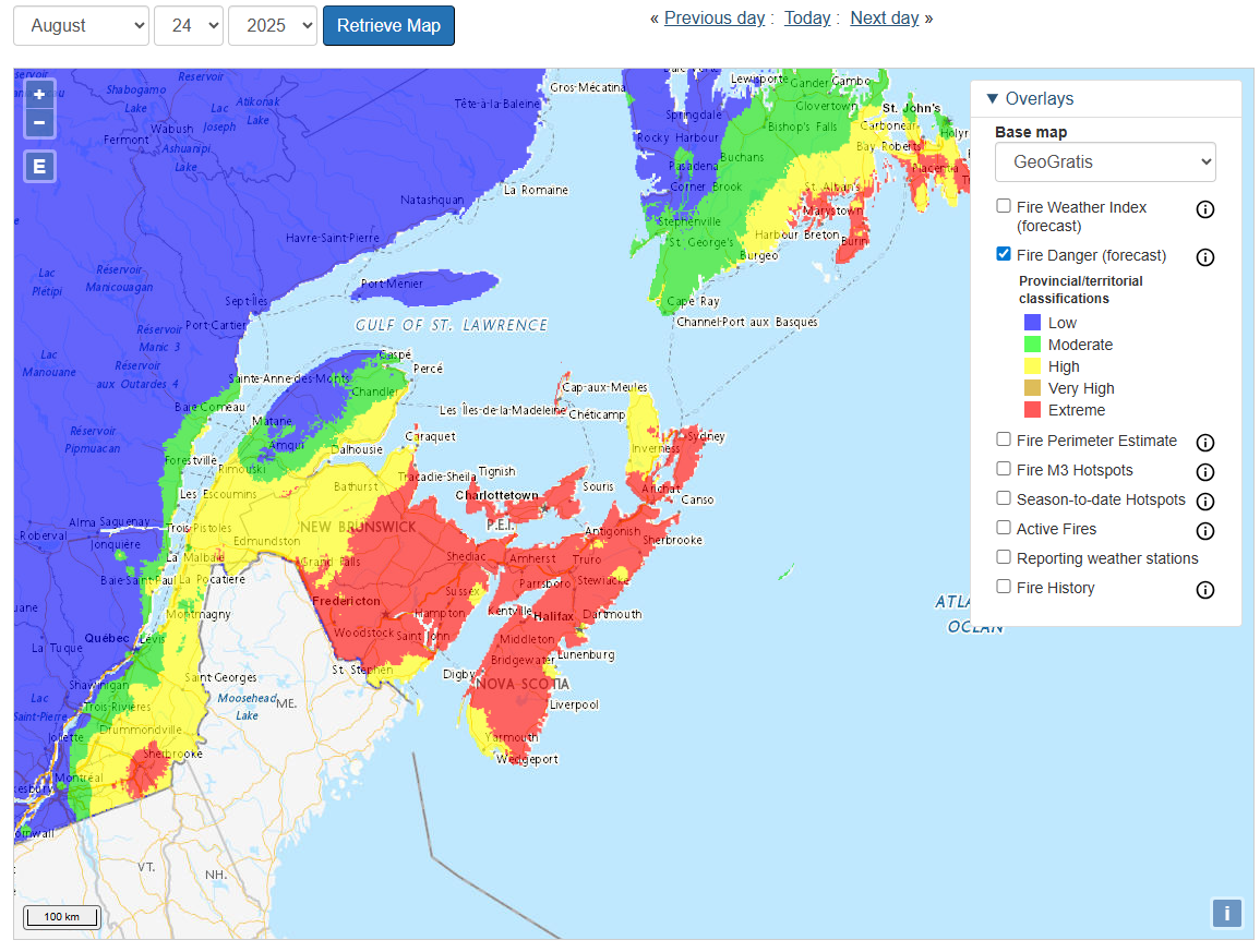
Wildfire risk remains high in Atlantic Canada today and tomorrow, with “extreme” risk for Nova Scotia, New Brunswick, and PEI today and tomorrow. While this is not directly related to Erin, the slightly breezier conditions from the storm and drier air in spots will not help matters should a fire start occur.
Extreme wildfire risk is in place today and tomorrow for portions of Atlantic Canada, with tomorrow’s outlook shown above. (Natural Resources Canada)
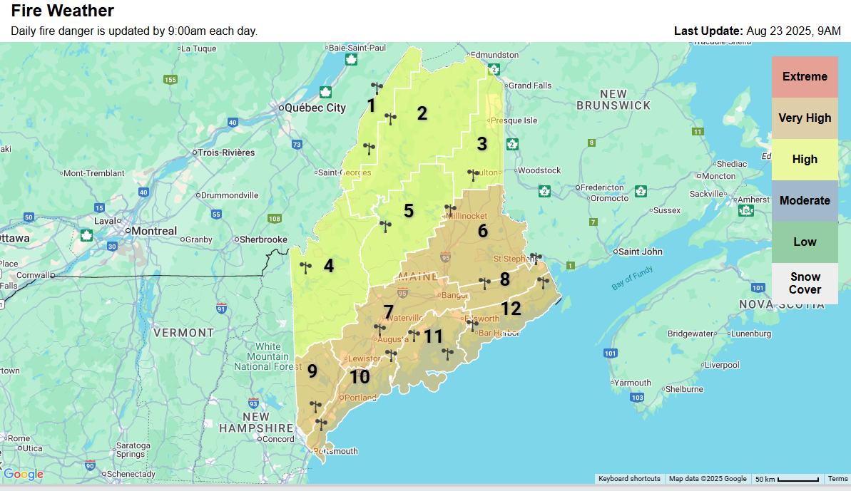
For Maine, the risk of wildfire is not considered high by the Storm Prediction Center, so this highlights a bit of a discontinuity between how the U.S. and Canada assess fire risks. That being said, the State of Maine has highlighted Downeast and some other parts of the state for a “very high” wildfire risk today.
High to very high wildfire risk for Maine today. (Mainefireweather.org)
Either way, conditions will gradually improve after tomorrow with some rain chances possibly returning to Maine on Monday and Atlantic Canada on Monday and Tuesday.
Invest 99L east of the Islands
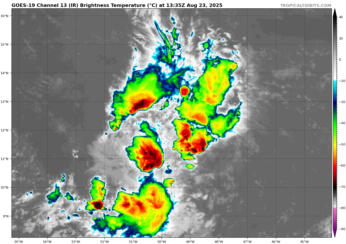
Well, Invest 99L has not changed a whole lot since yesterday, meaning it’s still got thunderstorms but it has little to no organization.
Invest 99L continues to flare up thunderstorms but has no organizational skills whatsoever. (Tropical Tidbits)
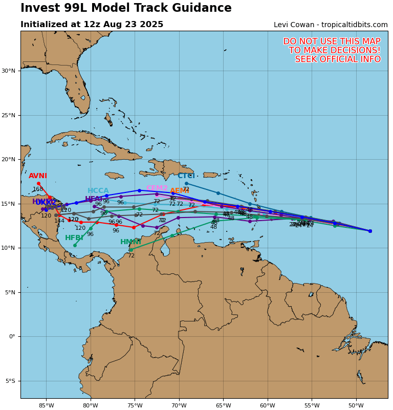
This disturbance is running through the gauntlet of significant wind shear at the moment, so you can forget any development today or tomorrow. The system will continue to book it westward into the Caribbean by Sunday night or Monday, bringing some locally heavy rain and thunderstorms to the Windward Islands in particular. This disturbance is pretty far south. In fact, of the August and September cases of a tropical depression moving through this area, almost all end up in Central America. Based on the model forecast tracks of this one, I would suspect 99L never develops and tracks straight into Central America between Belize and Nicaragua as a locally heavy rain producer.
Invest 99L should continue basically due west toward Central America over the next week. It probably never will develop. (Tropical Tidbits)
That said, we’ll keep an eye on it just in case, but right now I don’t foresee this one becoming a problem.
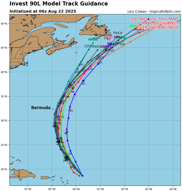
Invest 90L south of Bermuda
The system south of Bermuda that’s designated as Invest 90L is a little more interesting than the other items on the map. In fact, the National Hurricane Center gives 90L a 100 percent chance of developing this weekend. Basically, expect our next tropical depression before the end of today.
Invest 90L is on the cusp of becoming our next tropical depression or tropical storm. (Tropical Tidbits)
The disturbance is moving northward, and that motion should continue over the next several days. This should keep the center of the system about 200 to 300 miles east of Bermuda at its closest pass on Sunday night. Impacts would probably be limited to rough seas and some gusty winds. From there, this system will track north before merging onto the same highway Erin is taking to exit off to the east-northeast and out to sea. Look for this one to get on that highway by Monday night or Tuesday. Invest 90L will be a quick one to exit the pipeline. The next name on the list is Fernand.
Looking ahead in the tropics
So, we’ve been talking about the above systems all week, and in some cases longer than that. What comes next? I…honestly don’t know. There may be some marginal support for a wave to come off Africa next weekend, but the models are not particularly bulled up on this one right now. I suppose low pressure could form along a cold front off the Carolina coast next week; that’s a common pathway to development, but there isn’t exactly significant model support for that right now either.
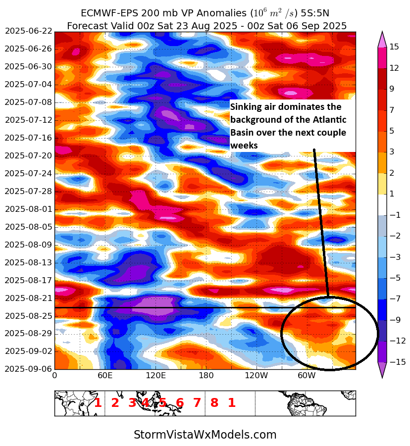
The background state of the Atlantic will feature sinking air over the next 10 to 14 days, which is not supportive of significant tropical development. (StormVista)
There are two important signals right now in model guidance. Above, I have a plot showing rising air (blue/purple) and sinking air (warmer colors) in the background of the atmosphere. This is called a Hovmoller plot. Where there is rising air, in general, that’s supportive of thunderstorms in the tropical latitudes. Where there is sinking air, that is not conducive to thunderstorms in the tropical latitudes. While this doesn’t exactly tell you everything, it indicates that the Atlantic is likely going to be fighting an uphill battle over the next 2 weeks, trying to shrug off a background state that leans it more toward subsidence, or sinking air. This likely suggests below average activity, especially given that this is occurring in two of the most active weeks of hurricane season historically.
The ECMWF weekly modeling continues to suggest below average activity in the entire Atlantic Basin in the first week of September. (ECMWF)
The ECMWF model backs this up, as it shows the entire Atlantic basin with below average activity forecast in the first week of September (Sept 1-8).
What should you take away from this? We have a long way to go in hurricane season, but the next two weeks, some of the most active historically, may see a well-timed relaxation in the Atlantic.
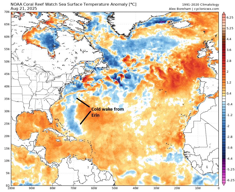
Water temperature anomalies in the Atlantic remain above normal, but you can see Erin’s cold wake showing up rather clearly. (Cyclonicwx.com)
Of course, a quiet period will eliminate most of the benefits of Hurricane Erin’s cold wake from all the water it stirred up. Across the Atlantic water temperatures are warmer than normal but generally well short of records set in 2023 and 2024, with one exception, the Gulf, especially the eastern Gulf. Gulf water temperatures are near the top of the charts historically right now, and if and when activity does get back to normal, we’ll hopefully see the Gulf avoid things. For now, we have a nice stretch of time to not worry, which is always welcome in August and September.
In brief: Erin is chugging out to sea now, but not before possibly delivering an enhancement to already extreme wildfire risk in Nova Scotia, New Brunswick, and Prince Edward Island. Rough surf and rip currents will linger on the East Coast and in Atlantic Canada through Sunday. Invest 90L remains worth monitoring for Bermuda. Invest 99L is worth monitoring for the Windward Islands. And flooding chances mix with beneficial rainfall heading into next week in the southern Rockies and Plains.
Hurricane Erin
(NOAA/NHC)
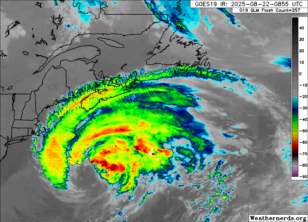
Erin is booking it this morning. The strong, sprawling category one hurricane is moving northeast at over 20 mph. The good news this morning is that all watches and warnings for land have been discontinued. Rough surf and rip currents will continue to impact the East Coast, Bermuda, and Atlantic Canada, but the worst of Erin’s impacts to land seem to be over now.
Erin looks like a hurricane that is beginning to undergo extratropical transition, except it’s gigantic. (Weathernerds.org)
What’s next for Erin? Well it remains a large storm, with a wind field of tropical storm-force over 350 miles now. It should pass well south of land, but gale-force winds are likely in southeast Massachusetts, Nova Scotia, and the Avalon Peninsula in Newfoundland as this passes. Rough surf with waves of 3 to 6 meters may break on the coast of Nova Scotia today and in the Avalon & Burin Peninsulas of Newfoundland later and tomorrow. Even as Erin weakens and turns extratropical in the cooler North Atlantic waters, the size of the gale-force wind field may grow further, keeping Erin a powerful feature on the weather map through the weekend.
Extreme fire risk for much of Atlantic Canada outside of Newfoundland today. (Natural Resources Canada)
That risk should remain and expand into Newfoundland tomorrow. For some areas, the risk may diminish as Erin passes, particularly for Newfoundland. In Nova Scotia, New Brunswick, and PEI, however, the risk may stay at extreme levels through the entire weekend. A rare situation for this part of the world.
Erin’s remnants will park themselves south of Iceland for a time before probably moving into Europe as a (much weaker) storm next week.
Invest 90L
Let’s work our way back south now to Invest 90L. This one continues to lack much organization today, but models continue to insist it will eventually get its act together.
Invest 90L has very broadly disorganized thunderstorms, but that’s it at this point. (Weathernerds.org)
Over the next few days, this broader area may try to consolidate some, and we should see gradual development into a tropical depression or tropical storm. Invest 90L will track around the western edge of high pressure just west of the Azores, meaning it will continue on a north-northwest or northward trajectory. Model guidance at this point seems to suggest it will stay east of Bermuda on its way north, but we’ll continue to watch this, particularly once we (presumably) get some development out of this area.
Tropical model guidance has a relatively tight spread keeping 90L east of Bermuda, but it’s close. (Tropical Tidbits)
Interests in Bermuda should continue to monitor 90L over the next couple days. We do not expect this one to explode and rapidly intensify to a high-end storm like Erin did. But we could see it quickly come together as a tropical storm.
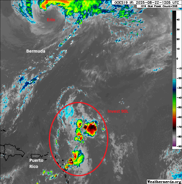
Invest 99L
Backing off to the south and east now, we look at Invest 99L. This one has had the opposite problem of 90L. Models have insisted it would eventually succumb to shear and dry air, and it’s been as resilient a wave as we’ve seen all season. Well, Invest 99L’s luck may be running out.
Invest 99L is looking much less organized and much uglier than it has all week. (Tropical Tidbits)
Over the next 3 to 4 days, Invest 99L will continue to have a puncher’s chance at perhaps sneaking into tropical depression status before likely getting ripped up again in the Caribbean. Interests in the islands should at least keep an eye on this, particularly for the Windward Islands. But this seems like mostly just a scattered heavy rainmaker right now. Beyond the islands, it seems likely that this will remain buried in the Caribbean or end up moving ashore in Central America eventually as a remnant disturbance. But we’ll continue to watch in case something should change.
Flooding risks
Yesterday saw a flash flood emergency, our first in quite some time, this one in Roanoke, Virginia. Read Kevin Myatt’s always excellent coverage in the Cardinal News for more on that event. But 3.38 inches of rain in an hour is more like Gulf Coast style than Appalachia. Very impressive stuff.
Flash flooding risk today will be mainly in Georgia and South Carolina back across the Gulf Coast, as a stationary front is draped across the region. But as we go into next week, we continue to see a pretty strong signal for heavy rain in the Plains. A slight risk (2/4) for excessive rainfall and flooding remains painted on the maps for Monday between the Front Range and Kansas & Oklahoma.
Slight risks for heavy rain (2/4) are in place on Monday from the Rockies to the Plains. (NOAA WPC)
Colorado Springs, Wichita, Tulsa, and Oklahoma City are all included here. For Tuesday, that risk shifts mostly back into Colorado and New Mexico. Rain totals over the next week continue to look quite healthy in these areas, with perhaps 1 to 4 inches in Colorado and parts of New Mexico and 3 to 6 inches in Kansas and Oklahoma.
Rain totals over the next week are stout between the Rockies and Plains. (Pivotal Weather)