Hey all—my name’s Lee, and I run the server side of The Eyewall (and Space City Weather, too!). Today we’re changing how comments work on both sites.
We’re moving from WordPress’ built-in commenting system to a new discussion platform called Discourse. The goal is to make it easier for us to moderate conversations, highlight thoughtful contributions, and cut down on off-topic noise. (For the longer version, see the “Start here: What is all this?! Answers within!” post on our new Discourse instance.)
Discourse!
What does this mean for everyone?
Starting today, instead of leaving comments directly beneath posts on SCW and The Eyewall, readers will follow a link to a dedicated discussion thread on our new Discourse forum. That thread will serve as the home for all conversation related to that day’s forecast post. The most recent replies from the thread—right now we’re showing 20, but that number might change—will automatically appear at the bottom of the forecast post, in the same place comments have always lived.
If you want to comment, follow the link down below that says either “Start the discussion…” or “Continue the discussion…”, which will take you directly to the daily post’s discussion thread. If you haven’t created an account yet, you’ll be prompted to sign up. Once you’re signed in, you can comment as usual!
It’s still early days here and we’ll be continually tuning how Discourse integrates with Space City Weather and The Eyewall. Some things might be slightly broken at first, but we’ll do our best to stomp on any issues as soon as they’re spotted. Voice any concerns in the Forum Feedback category on Discourse, and we’ll look into them.
Thanks for sticking with us, and whether you’re a newcomer or someone who’s been around long enough to know exactly when Katy should evacuate, welcome to the new commenting system!
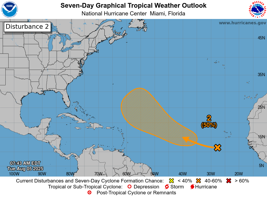
In brief: A disturbance off the Carolina coast has a 40 percent chance to develop heading into the weekend, but it looks to remain offshore. Tropical Storm Dexter may intensify over the open Atlantic as it transitions from tropical to non-tropical late this week, no threat to land. The area in the deep Atlantic with 60 percent development odds remains worth watching but not likely to stir up too much trouble.
Tropical Atlantic
We’ll continue our daily check up on the areas worth watching in the tropical Atlantic — and speculate on what could come next.
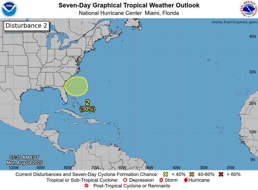
Carolina coast
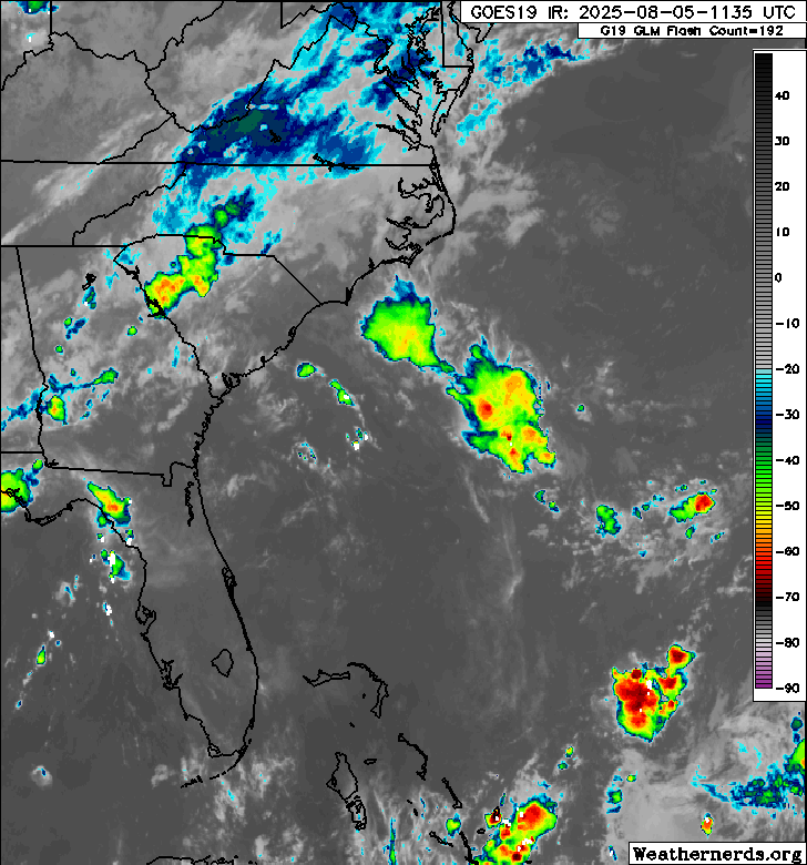
Starting closest to land today, some good news. The disturbance that’s expected to attempt to develop off the coast of the Carolinas appears that it will be less stuck than it appeared earlier in the week. Again this morning, there just isn’t a whole lot there yet.
The area we’re watching off the Carolinas is void of much of anything still today. (Weathernerds.org)
Initially, the thought was that we’d see development gradually through the week, followed by a very slow-moving or stationary type system off the coast. The first half of that statement is still true. Development will be very sluggish here. We won’t wake up to a tropical storm out of nowhere tomorrow. It may not be until Friday or Saturday that we see anything make a real effort to form. And from there, it now looks as though it will slowly but steadily move north and northeast, heading out to sea. Development odds have been pushed back to 40 percent this morning, indicating that this is not exactly expected to really get going once it does start to attempt development.
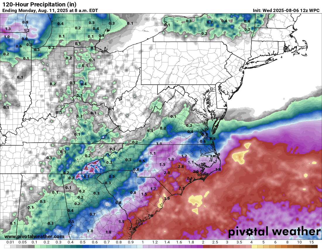
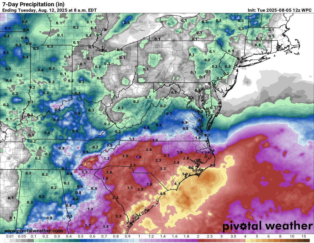
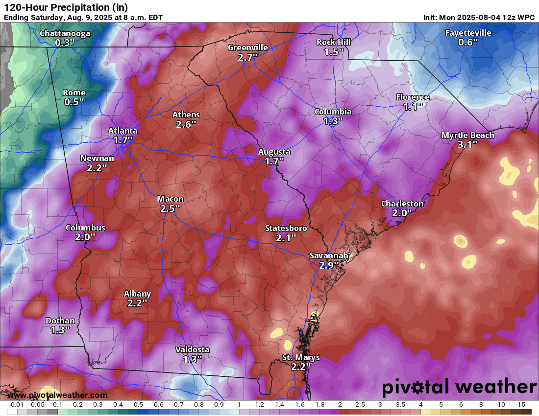
5-day rainfall totals peak at 3 to 5 inches near Myrtle Beach, with a widespread 2 to 4 inches between Cape Lookout and Florida. (Pivotal Weather)
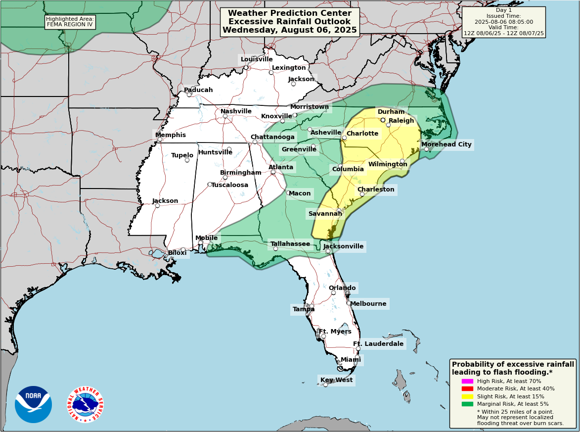
In terms of impacts: Rainfall and rip currents are at the top of the list. You can see the 5-day forecast average rain totals above. Locally higher amounts are possible, especially today in interior North Carolina and Georgia, where flood watches are in effect.
You can see a broad slight risk (2/4) posted from the Piedmont south to the Georgia coast for today for heavy rain and flooding. (NOAA WPC)
A lot of the rain is actually front-loaded and not directly related to the system itself, but the whole pattern is connected. Rip current risk is moderate to high on the North Carolina coast, and if any development does actually occur offshore, that risk will hold into the weekend. Just something to be aware of if you’re beaching it this weekend in the Mid-Atlantic or Southeast.
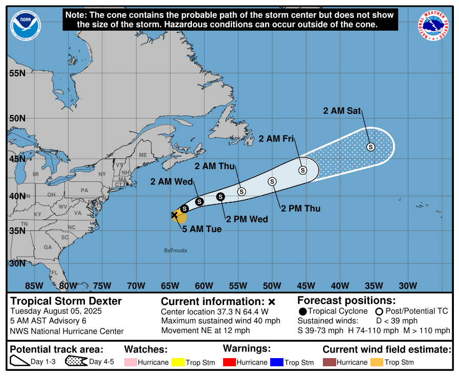
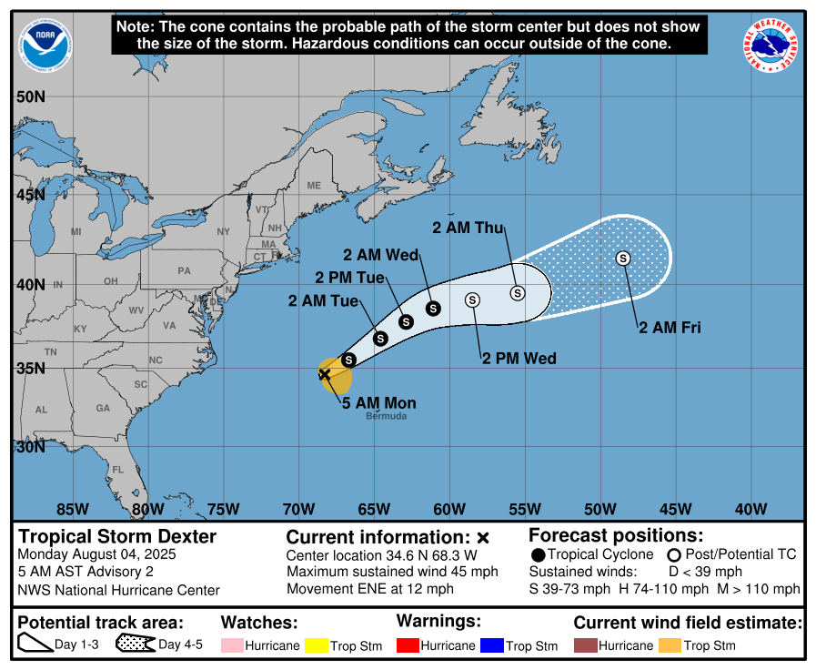
Tropical Storm Dexter
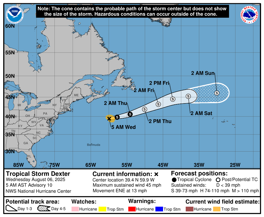
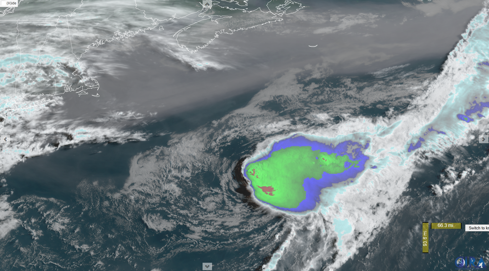
Dexter continues to cling to life as it moves out to sea.
(NOAA/NHC)
Dexter is expected to become post-tropical tomorrow and end up north of the Azores by Sunday as a non-tropical low pressure. From there, Dexter’s remnants end up getting tied into a storm system near or north of the British Isles by Tuesday or Wednesday of next week. No big impacts are expected right now.
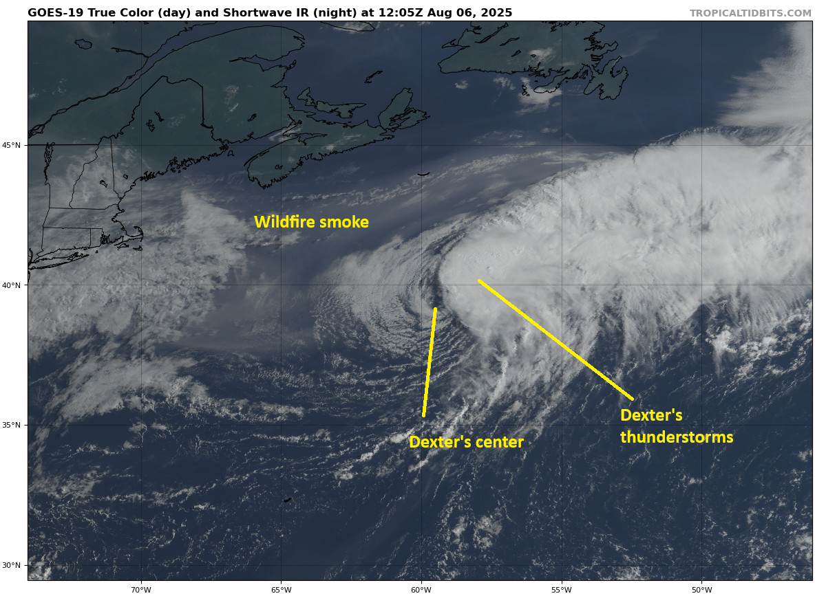
Tropical Storm Dexter has a lopsided appearance today. (Tropical Tidbits)
Dexter’s thunderstorms have outpaced the system itself, with the center again almost exposed entirely this morning. That’s a sign of an unhealthy storm. It’s just not in the greatest environment right now, packed with wind shear. That said, tropical systems have a funny way of doing things when they transition to extratropical systems. In Dexter’s case, while it may continue to look very sloppy, it’s likely to increase in intensity, with winds possibly approaching hurricane-force at some point in the next couple days. Thankfully that will remain over the water, though some rough seas could be generated in Atlantic Canada.
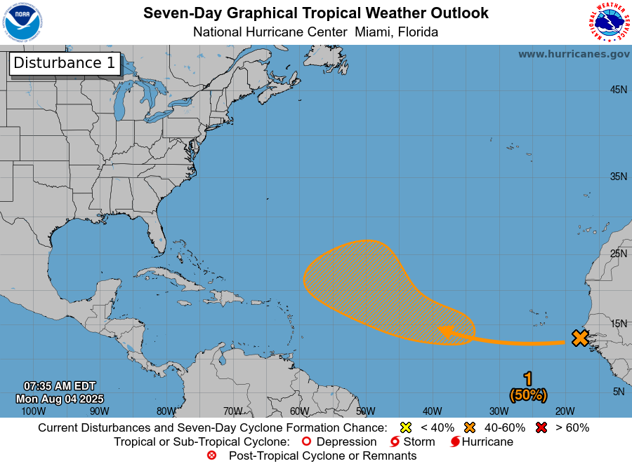
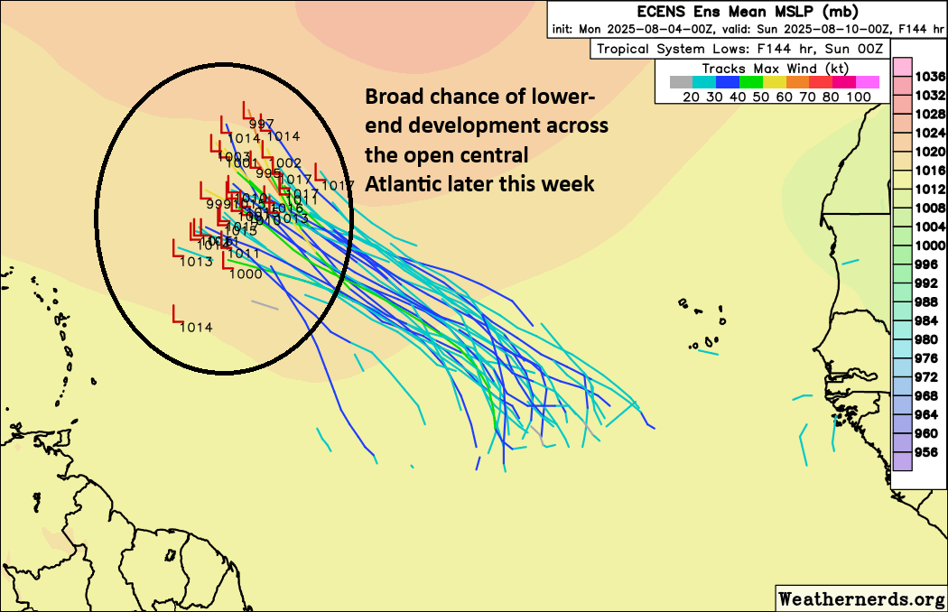
Deep Atlantic
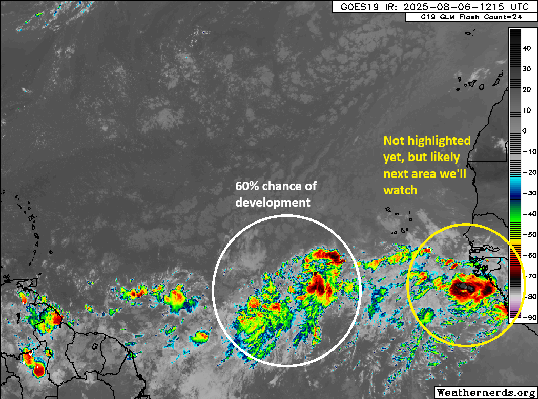
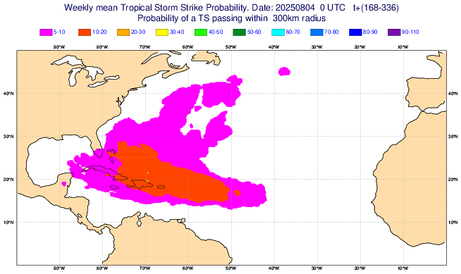
We are watching two areas in the Atlantic. There is the one being highlighted by the NHC with a 60 percent chance of development. There is also what will probably be the next highlighted area by the NHC in a day or two.
The tropical wave associated with 60% odds of development looks a bit better this morning, while the next wave emerges off Africa behind it. (Weathernerds.org)
The 60% area looks a good deal better this morning than it has the last couple of days. We will probably see some gradual organization attempt to occur from this one between now and Friday. I wouldn’t be shocked if the 60 percent becomes a 70 or so by later today. In terms of this one’s future, it will probably have a relatively low ceiling for intensity. But a depression or tropical storm seems like a decent possibility at this time.
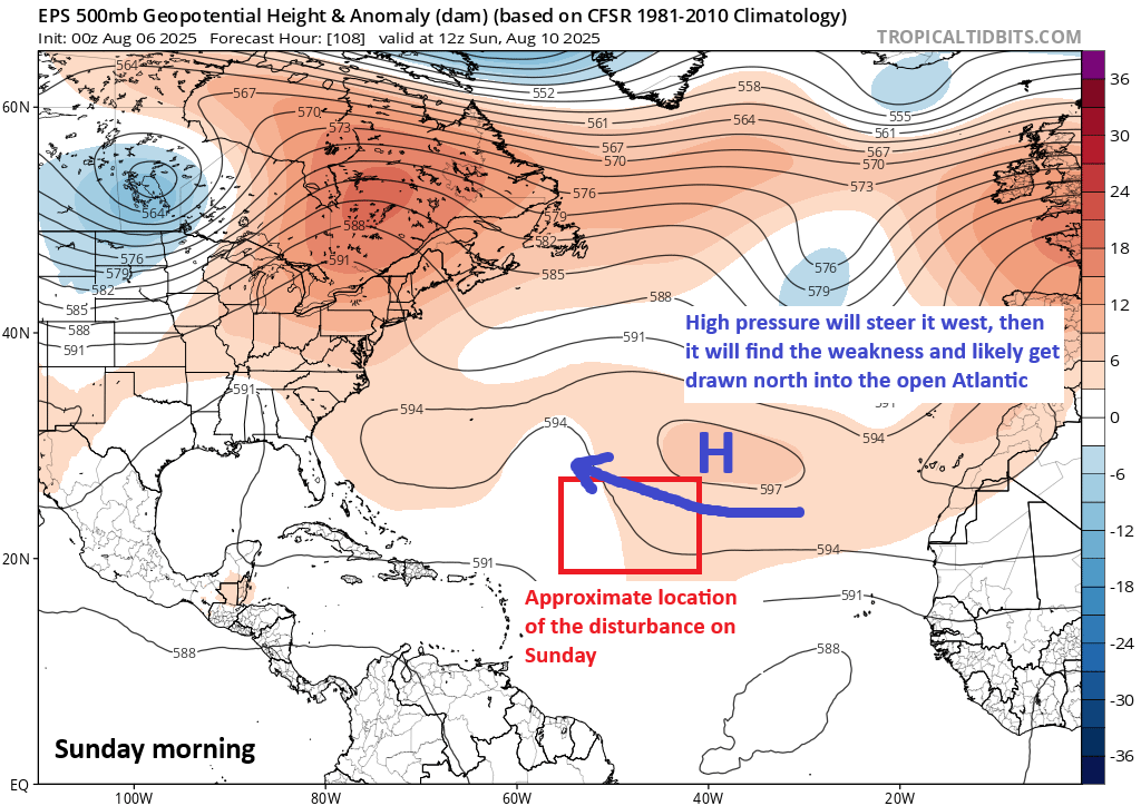
As the system moves, it will be steered west northwest or even northwest at times around the periphery of high pressure in the eastern Atlantic. By the time it gets to the weekend, high pressure may strengthen somewhat and force to turn back more to the west for a short time. Eventually, it will likely hit the escape hatch and get drawn back northwest and north through a weakness in the high pressure across the basin.
The system in the Atlantic will be steered around high pressure in the middle of the Atlantic, but it should find a weakness in the pattern by early next week, allowing it to escape north and eventually out to sea. (Tropical Tidbits)
This should allow the system to ultimately turn out to sea. I would say it’s probably worth continuing to monitor for the Caribbean or Southeast or Bermuda, but it’s unlikely to stir up too much trouble.
On the image atop this section, I did highlight the area behind this disturbance as one to watch as well. Model guidance keeps this one a little more southward in the Basin, which could in theory allow it to get closer to more land in 10 to 12 days. There is very little consensus on this one yet though, so for now it’s just probably the next area we’ll watch but nothing more than that.
In brief: Tropical Storm Dexter is sloppy this morning but continues to head out to sea. An area just off the Carolinas now has a 40 percent chance of developing, and it will likely be a heavy rain, rip current, and tidal flooding risk. Deeper in the Atlantic, nothing looks overly concerning, but we continue to see signs of life and development chances in the future.
Tour de Tropics
UnambiDexterous
Dexter is only moving in one direction, and that’s out to sea.
Tropical Storm Dexter south of a massive plume of wildfire smoke over the open Atlantic. (Colorado State CIRA)
Dexter’s center was exposed some earlier this morning, but it appears that thunderstorms have blossomed back over it after sunrise. Still, this is trending downward overall, and it wouldn’t be a shock to see Dexter go post-tropical by tomorrow as it races out to sea.
(NOAA/NHC)
Dexter’s remnant circulation will probably be absorbed by a storm system moving into northwest Europe, most likely near or north of the British Isles by early next week.
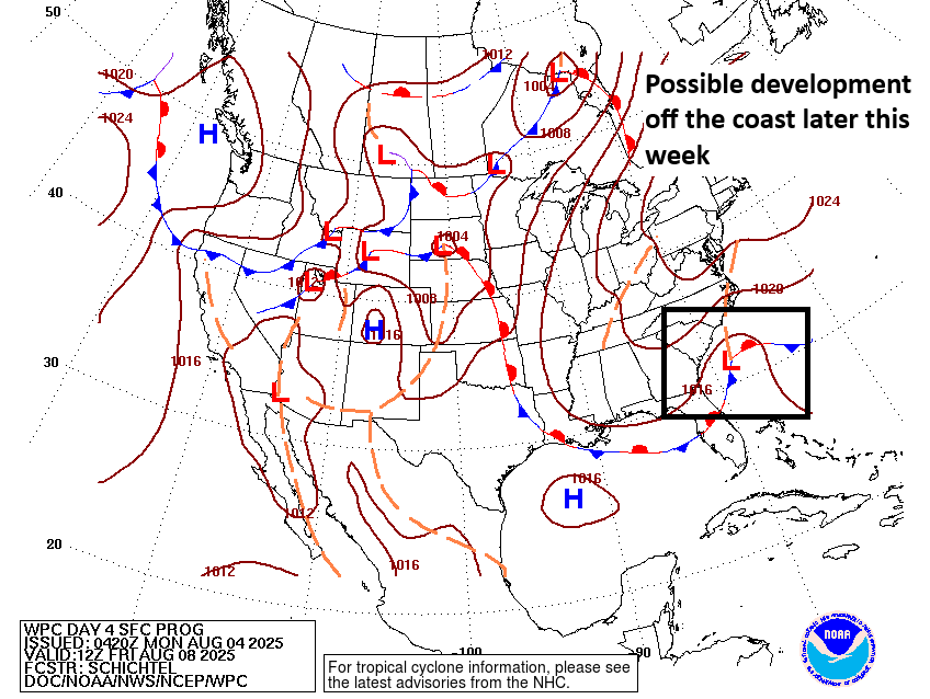
Southeast coast
Next on our tour, we look close to home. There’s not much to see this morning with just some scattered clusters of thunderstorms off the coast of the Carolinas.
Disorganized clusters of thunderstorms sit off the Southeast coast on Tuesday morning. (Weathernerds.org)
Over the next 36 hours or so, low pressure may develop in this area, however, and that’s when things may get a touch more interesting. This area was just bumped to 40 percent odds of developing over the next several days. At least today, it does not appear that whatever develops in this region will get terribly strong. But the overall environment is favorable for slow strengthening, as are water temperatures. One interesting thing about this is that steering currents don’t exactly look strong in this area. In other words, whatever this is will probably not move a ton, at least not in the first few days.
Heavy rain is likely on the coast of North and South Carolina, as well as perhaps over the Piedmont and in the Smokies. (Pivotal Weather)
The initial concern on this will be rip currents on the coast of North and South Carolina, as well as heavy rainfall. Should a system develop and organize some offshore, obviously we’d watch that for the direct tropical risks. If it just sits and spins offshore, we’ll probably want to watch for coastal flooding risks from Virginia into South Carolina.
Bottom line at this point: We should continue to monitor this area over the next couple days, especially because of its proximity to land. At this time, it seems as though rain, rip currents, and perhaps tidal flooding will be the primary issues from this area.
Wild card? A handful of ensemble members develop the low pressure area farther south, closer to Florida. While that is a minimal minority of ensemble members, it’s at least something to perhaps keep a side eye on. It’s far less likely than something off the Carolinas though.
Deep Atlantic
Last on our stop, the deep Atlantic, where the NHC continues to outline a broad 50 percent risk area.
(NOAA/NHC)
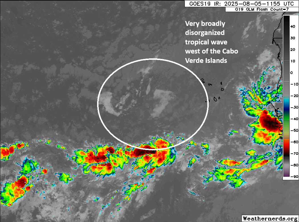
The tropical wave that is responsible for this area continues to produce little to no thunderstorm activity. There are storms to its south, but it’s spread so thin that there’s nothing to this at the moment. Over the next few days, we could see some gradual consolidation and organization occur.
There is virtually nothing to the tropical wave today. Over the next couple days, we could see some gradual consolidation. (Weathernerds.org)
This wave should move more to the west-northwest or northwest over the next few days as it makes an attempt to organize. The most likely scenario still takes this out to sea via a weakness in the subtropical ridge across the Atlantic.
More to come
Interestingly, the next wave or two that emerge off Africa may carry a slightly better chance of organizing. In fact, if you look at yesterday’s European model subseasonal forecast for the week of August 11th through the 18th, you’ll see somewhat bolstered odds of development closer to the Caribbean islands.
Slowly increasing potential for tropical development later next week across the Southwest Atlantic or near the islands. (ECMWF)
I will say, the models have been a little overzealous this year in developing risks in the Atlantic MDR in particular. Given that it’s now August and forecasts are pushing into mid-August, we should give those forecasts respect, but thus far it’s been tough sledding out there for any tropical systems. Could that continue? Certainly. So nothing is a guarantee here, but again, as you would expect heading into mid-August, the Atlantic is a little noisy. Stay tuned.
In brief: There are three items in the Atlantic today. Dexter is heading out to sea. A low pressure system may develop off the Carolina coast this week, keeping wet weather in play for the Southeast. A third area emerging off Africa this week has some chance to develop, but it’s getting one model with a poor track record excited.
Atlantic tropics
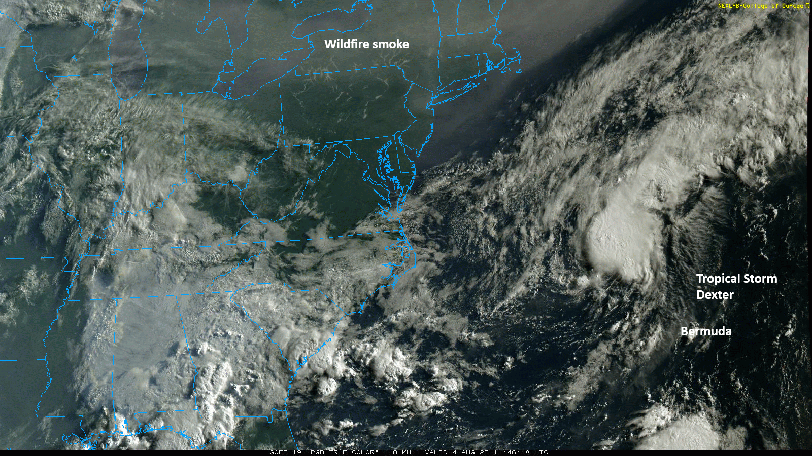
We have our fourth storm of the hurricane season today, thankfully not a threat to land. We’ve also got some other business to attend to in the basin. So, let’s get started.
Tropical Storm Dexter
(NOAA/NHC)
Invest 95L became Tropical Storm Dexter late yesterday. Dexter is already exiting stage right, moving east northeast around 10 to 15 mph. By the end of the week, Dexter should be post-tropical. Eventually, this will probably end up in the British Isles, either as part of another typical European storm or as a passing disturbance. Either way, it’s mostly just a curiosity than anything else.
Satellite image from Monday morning showing Dexter and a ton of wildfire smoke across the Northeast and Great Lakes. (College of DuPage)
Deep Atlantic area of interest
(NOAA/NHC)
A tropical wave emerging off Africa today carries a 50/50 chance of developing as it moves into the open Atlantic this week. Currently, there is little to see with this tropical wave, as it’s basically producing no shower or storm activity. However, by the time we get to later Tuesday or Wednesday, we do expect this thing to fire up some. From there, model guidance is in good agreement on decent odds of development. The European ensemble is probably the most bulled up about this one (see below), but the various AI modeling and ensembles also support development.
A small majority of the European ensemble supports development of a tropical wave off the coast of Africa by later this week or weekend. (Weathernerds.org)
Some GFS operational model runs have gotten a bit spicy with this, keeping it middling into next week before trying to push it due west toward the Southeast as a strengthening system. There’s not a whole lot of additional support for this scenario, so the GFS appears to be an outlier in this regard. The reason it seems to be doing this is similar to what we described in yesterday’s post, about a “weakness” in the ridge over the Atlantic that would allow the system to turn north and exit. The GFS keeps the system fairly weak, which would make it a little less likely to turn north into the weakness and out to sea. Then, as the system it strengthens, it rebuilds the ridge to the north, basically forcing it to continue due west or northwest toward the Southeast.
The timing of this diversion from the overall consensus view of out to sea seems to be in the Sunday through Tuesday timeframe, so we’ll get a fairly quick resolution to this through the week as the overarching weather pattern clears up. I suspect we’ll have a good idea if this is an actual Southeast concern as the GFS operational suggests by midweek. Historically, the GFS does not have a good track record when going it alone in scenarios like this, so we’ll keep an eye on it but we’re far from being concerned about it at this time.
Closer to home
Meanwhile, a newer 30 percent area got drawn yesterday afternoon off the Southeast coast.
(NOAA/NHC)
Behind Dexter there is still a remnant stationary front off the coast of the Southeast. Over the next few days, we’re probably going to see a weak area of low pressure develop along that remnant boundary. Unlike Dexter, this won’t get whisked out to sea. Rather, it looks likely to just kind of sit and spin for a bit.
Friday’s forecast map from NOAA shows weak low pressure off the South Carolina coast. (NOAA WPC)
To be honest, I’m not super concerned about significant development here. However, this may make for a somewhat dreary week along the Carolina coast. Rain totals may begin to add up some in this area as well through the week.
It looks like a wet week for Georgia and South Carolina, as well as parts of North Florida. (Pivotal Weather)
So overall this is worth keeping tabs on, but it is probably not a serious concern.
There’s more to discuss non-tropics, but we’ll save that for later or tomorrow.