In brief: Melissa is on the cusp of hurricane intensity this morning as it continues to track west at a painfully slow rate of speed. Forecasts now favor a major storm turning north closer to Jamaica, which may lead to a direct hit on the island. Regardless, catastrophic rainfall will impact communities in southwest Dominican Republic, Haiti’s Tiburon Peninsula, eastern Jamaica, and portions of southeast Cuba before Melissa exits into the Atlantic next week.
Melissa almost a hurricane
Since yesterday, Melissa has continued to get its act together, and as of earlier this morning, the storm was very near hurricane intensity. It should get there sometime today.
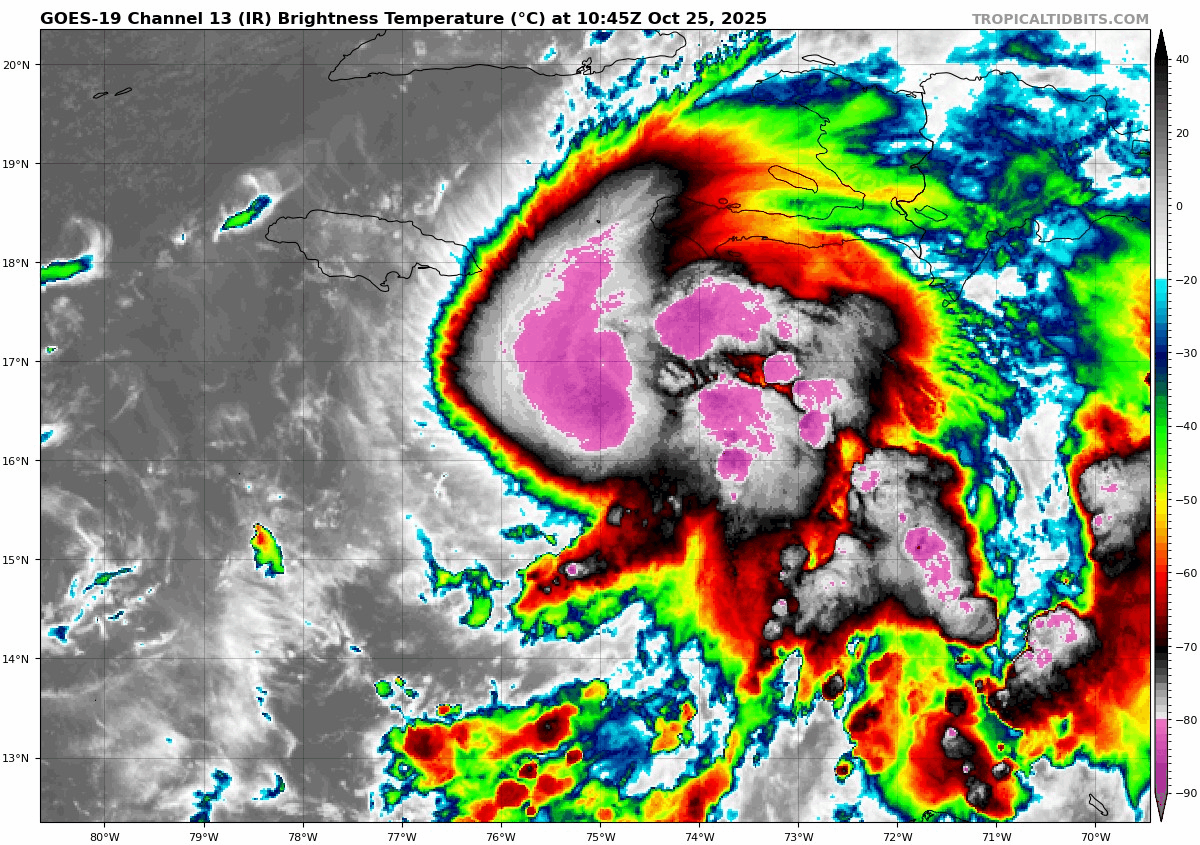
At times, an “eye” has tried to emerge as well, so Melissa has shrugged off most of what was ailing it earlier this week.
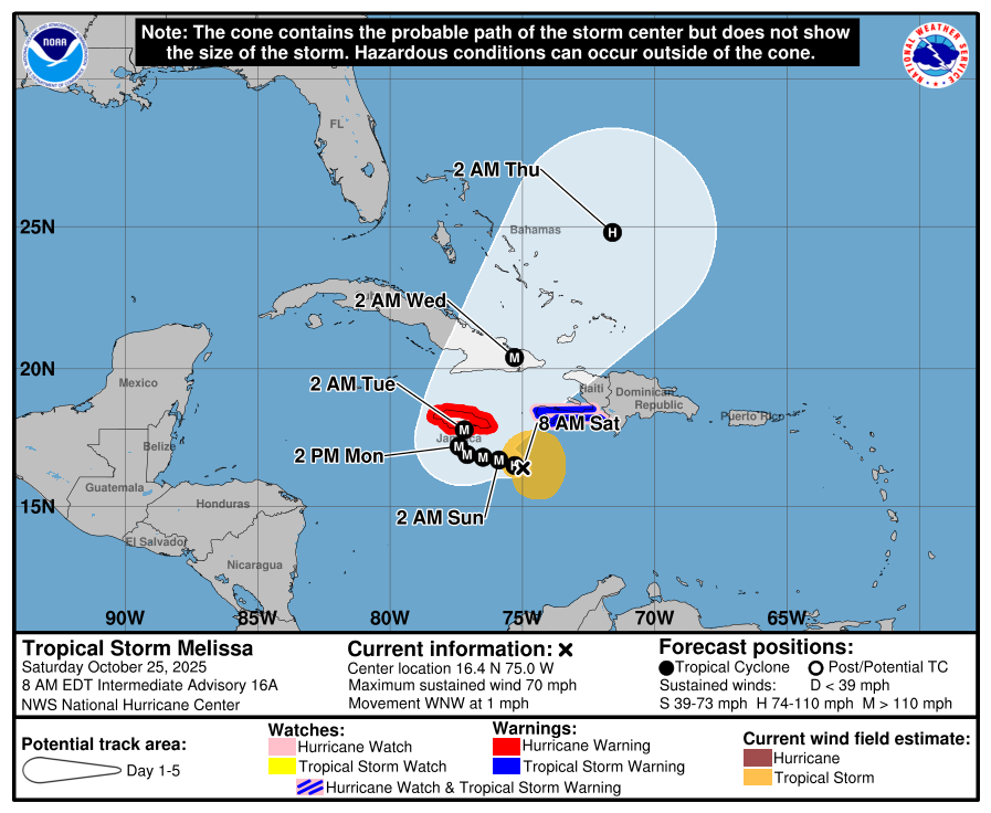
Melissa’s perilous track & strength
Because of the excruciatingly slow movement of Melissa, a couple changes have occurred today in the track forecast. First, most modeling now turns Melissa northward from due south of Jamaica. This means the odds of a direct hit on Jamaica by a major hurricane are now high, in addition to the several days of tropical storm conditions and torrential rain that will precede the worst of the storm. Even for a hurricane battle tested location, this will be a pushing limits of what is tolerable.

Once past Jamaica, Melissa will likely make landfall in eastern Cuba, before tracking over either the southeast Bahamas or Turks and Caicos Islands. The islands south and east of about Exumas are probably at highest risk for severe impacts right now. From there, Melissa hauls out to sea, though folks in Bermuda should now be watching Melissa’s progress closely (though it will certainly be a less intense storm once that far north).
Over 80 percent of Google’s Deep Mind ensemble members bring Melissa to Cat 4 or 5 intensity, with some of the better performing overall hurricane models and consensus aides, firmly in the category 4 camp right now. Whether it is a 3, 4, or 5, the odds favor it being a major hurricane and perhaps a higher-end major at that as it barrels into Jamaica and Cuba. The storm should begin to weaken beyond Cuba due to land interaction and a more hostile overall environment. But even in the Bahamas, we could still be looking at a borderline major hurricane.
Powerful storm surge is likely in Jamaica and eastern Cuba as Melissa turns northward next week.
Catastrophic rainfall
Despite the intensity of the hurricane, the hallmark of this storm may well be how much rain falls, with totals of 30 inches or more possible in southwest Haiti and eastern Jamaica. Given how explosive the thunderstorms are east of the center, day after day of rain is likely in these areas.

It is not hyperbole to say that this amount of rain will be catastrophic for these areas. Landslides, mudslides, and isolation for several days will all be likely in some communities. Those 30 inch (750mm) totals will be isolated in all likelihood and terrain driven. But the entire eastern half of Jamaica should see at least 10 inches of rain (250mm), which will cause widespread problems.
Don’t forget about southeast Cuba (easily could see 15 inches of rain (375mm) and southwest Dominican Republic which could see upwards of 20 inches (500mm). We are talking about a widespread flooding event across several different countries in the Caribbean.
Bottom line today
- A major hurricane, quite possibly a high-end major hurricane will probably directly hit Jamaica by Monday night.
- The storm will then make a direct hit on Cuba as a powerful hurricane and track through the southeast Bahamas as a borderline major hurricane.
- Bermuda should be monitoring the future track forecast of Melissa.
- Catastrophic rainfall will impact Jamaica, Haiti, the Dominican Republic, and southeast Cuba with upwards of 30 inches in a few spots. Mudslides, landslides, and complete isolation of some villages are all likely.
- In many cases, severe flash flooding will commence 24 to 48 hours before the core of the storm hits in Jamaica and Cuba.
- Along and near where Melissa tracks, significant storm surge is likely.
We continue to send our thoughts to these Caribbean communities that will be dealt another in a long history of bad storms.