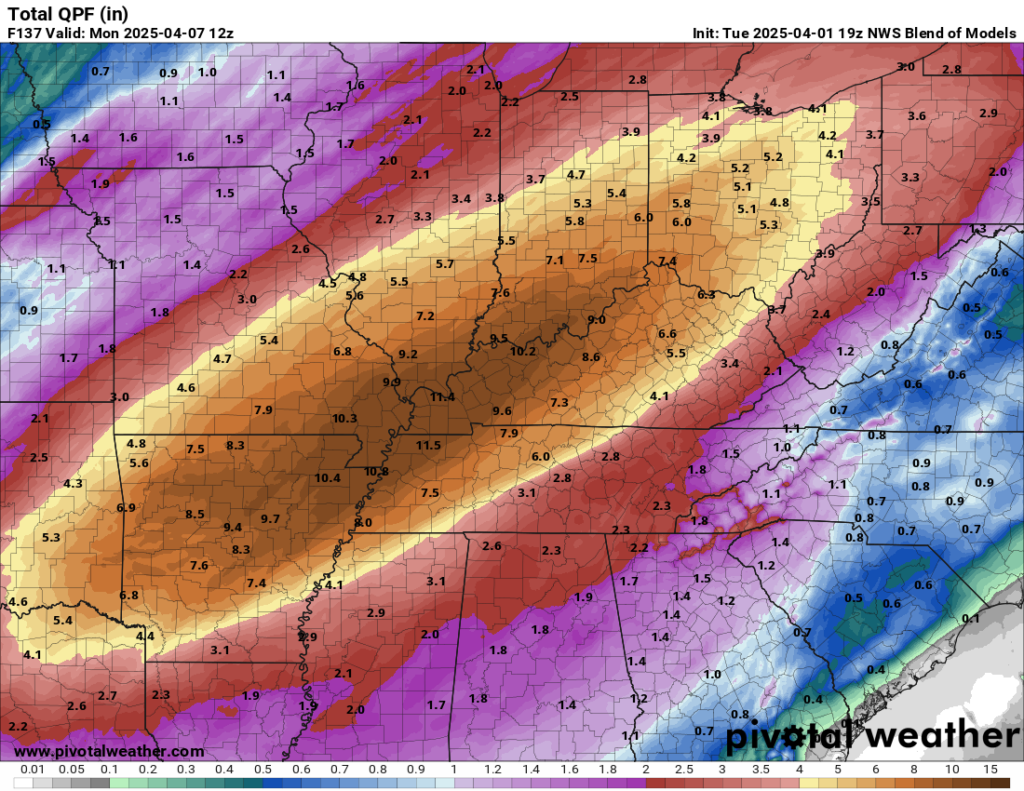
The National Weather Service in Paducah, KY did not mince words this afternoon in their briefing on the upcoming rainstorm across the Ohio Valley: “Significant and potentially historic rainfall will begin Wednesday afternoon, with numerous rounds of heavy rain continuing into the first half of the weekend, leading to potentially catastrophic flash flooding.”
I have a whole post eventually coming to my Substack page on words and how we use them. But suffice to say, whenever the NWS uses a word like “catastrophic,” it is an extremely deliberate decision that more than one person agrees to. In other words, they understand the weight of the word “catastrophic,” and after discussing it as a team, they agree to use that phrasing. Because they’re convicted of an outcome that they believe will indeed be possibly catastrophic.

And the model data today continues to provide ample additional support for a wide ranging, widespread, potentially historic and/or catastrophic outcome. Within their area forecast discussion, the technical briefing the forecasters at the NWS provide that essentially explains or justifies their decision-making, the Paducah office maintained that type of language. “We cannot overstate the extremity of the flooding danger with this event incoming and these historic forecast rainfall amounts.”
To the north, in Indianapolis, their forecast discussion stated it had the potential to be one of the most significant rain events in the last 15 years. “This has the potential to be near the top of the list for highest impact heavy rain/flooding events for central Indiana in the last 15 years.”
Same story in Memphis, where their office also warned of catastrophic flooding. “Catastrophic flooding remains possible in portions of the Mid-South Wednesday through Saturday as the previously discussed front stalls right along the I-40 corridor.”
I wanted to just post that so folks, especially new visitors, didn’t think that we’re just randomly going ballistic over something. No, this is objectively a very serious threat between Arkansas and Ohio that is going to make the national news. All we can do at this point is hope for the best.
A very serious severe weather threat
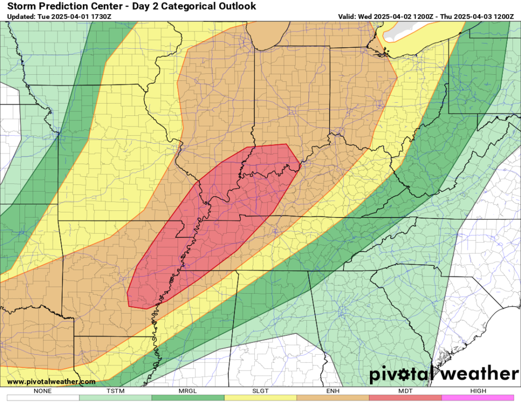
There will also be severe thunderstorms at times, especially tomorrow (Wednesday) and Saturday I think.

Being from Houston and having dealt with a 5-day rain event in 2017 by the name of Harvey, these types of events are long-duration tests of will. I’ve found that rather than trying to focus on every single element of the threat, it’s better to break it into manageable chunks. Today, that’s the overall rainfall threat (as laid out above), in addition to Wednesday’s severe threat. The moderate risk (4/5) was issued to cover all forms of severe weather (strong tornadoes, large hail, and damaging wind gusts), and all of them look potentially potent tomorrow. I will refer you to your local NWS office or some of the other fine weather blogs out there for more on the severe threat. There will be additional rounds of strong to severe storms across the Mid-South through Saturday, with perhaps Saturday itself being the second peak day of the event, in addition to peak concerns about flooding.
Stay safe everyone.
I don’t understand, are you meaning that Houston is under severe threat too?
No. The Eyewall covers nationally. There is no threat to Houston.
Ok, ty I was really getting worried
I’m supposed to be going on a road trip from Texas to Maryland this weekend because I’m moving. I’m really worried about the weather now.
Do you realize that most people in the US cannot locate themselves ( states they live in ) on a map of our country? I suggest labeling states in the maps you supply?
This is terrible. We have had our significant rain events in Mississippi but we can handle it a lot better than these states up north. Our last event laid down 10 inches in some places last April
How much will Nashville be affected? We have a daughter in college. Thank you for all of your hard work!