Headlines
- Major flooding just south of Wilmington, NC has been occurring due to Potential Tropical Cyclone 8.
- Additional rain and flooding, in addition to significant marine impacts and coastal impacts on the North Carolina coast are expected in the region through tonight as PTC 8 moves inland.
- Gordon is a depression, but no other systems are noted in the Atlantic or off Africa right now.
- We continue to see signs that the Caribbean will be the next place to watch next week, with potential development continuing to show up as noise in the forecast.
PTC 8 causing a ruckus in North Carolina
The good news is that Potential Tropical Cyclone 8 is running out of time to potentially become a tropical cyclone. The bad news is that it has been causing a lot of mischief in North Carolina since yesterday.
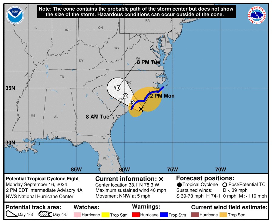
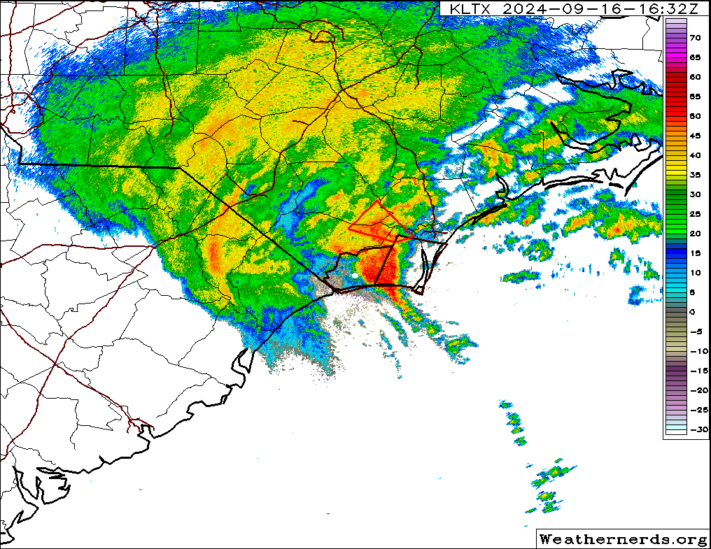
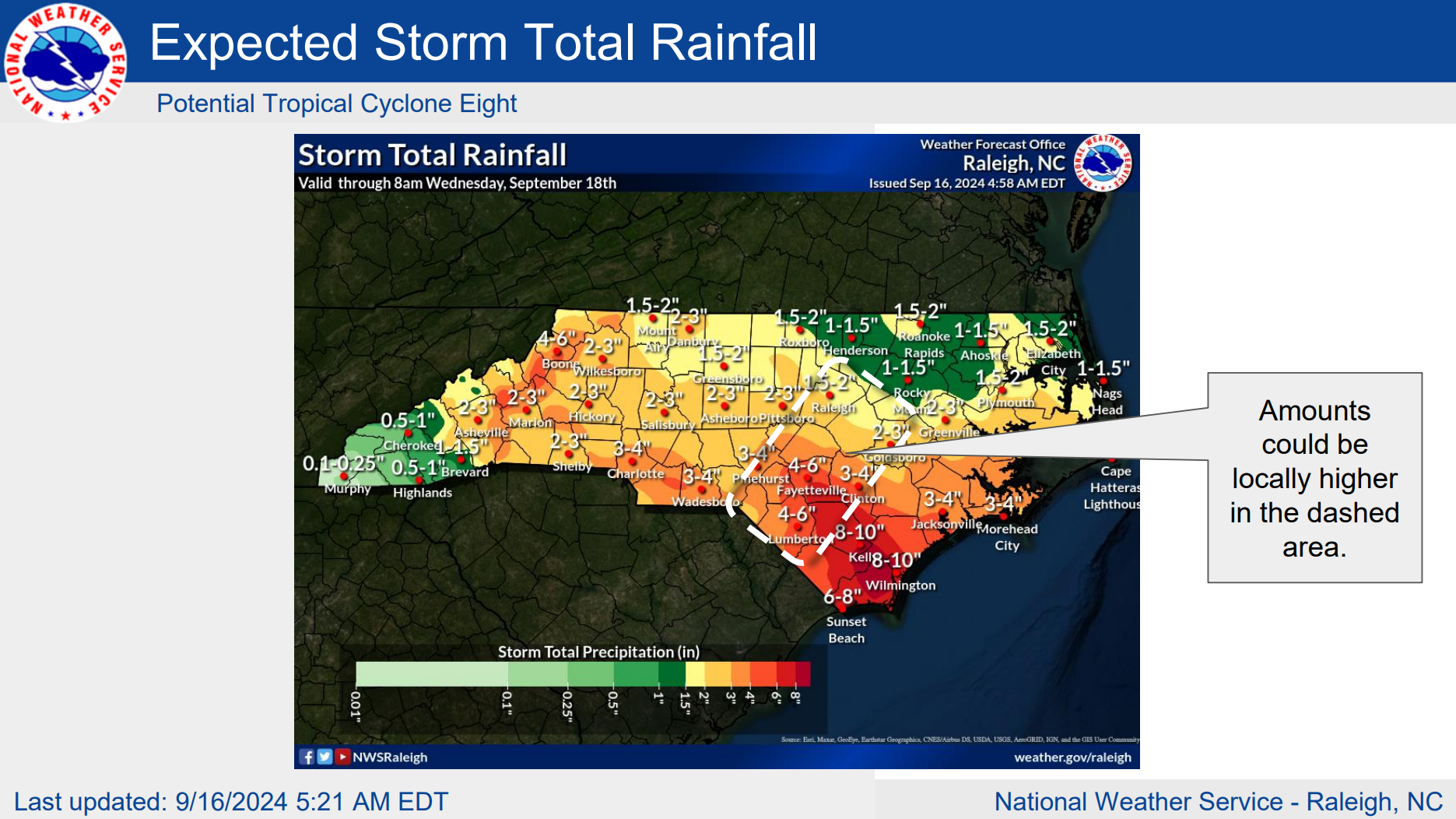
Rain totals have been absurd in some parts of North Carolina, almost doubling forecast expectations for the week. The Wilmington, NC area has been especially hard hit with a bullseye of radar estimated rainfall near 20 inches just south of the city. The highest official total I can find is 15.25″ at Sunny Point, which aligns well with the scale below. There has been severe flooding in portions of Brunswick and New Hanover Counties, in North Carolina.
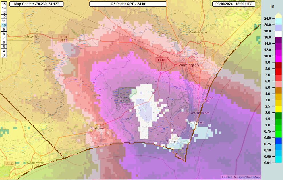
Recurrence intervals appear to be over 200 to 250 years with this rainfall, making this an exceptional, historic event for this area.
Rain continues, though there may finally be some feeder band movement offshore that indicates a focus may shift out of Brunswick and New Hanover Counties and off to the northeast a bit. Those areas have seen comparably less rainfall.
Winds have been ripping as well, with gusts as high as 67 mph in Wrightsville Beach, 64 mph just south of there on Masonboro Island, and 60 mph in Wilmington. A 77 mph gust at Sunny Point south of Wilmington was taken a bit elevated, at 30 feet, so it may not be especially representative. But anyway, this is why we noted yesterday that whether it is or isn’t a tropical storm (it still isn’t technically) the impacts would be the same.
Not to be outdone, but winds and waves have been solid and high farther up the North Carolina coast with some damage to homes being reported as far north as Rodanthe on the Outer Banks. Beach erosion and ocean overwash is likely to continue into tonight across the North Carolina coast as PTC 8 moves inland. Coastal flooding of 1 to 3 feet is likely as well, with waves of 8 to 12 feet near the coast and to the north of Wrightsville Beach or so. Things will settle tomorrow.
In addition to all this mess, isolated tornadoes are a good bet in parts of eastern North Carolina.
Flood risk will move inland tonight, with totals of anywhere from 3 to 7 inches between the western North Carolina mountains, Charlotte, and into southeast North Carolina away from the coastal deluge. Higher amounts are likely in a few spots, especially near or south and east of Raleigh.
Rains will become more scattered after today and tonight, and conditions will generally improve in North Carolina and the Mid-Atlantic after that.
Gordon downgraded, and no other Atlantic Ocean items to watch
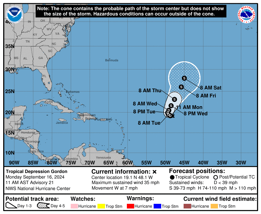
Tropical Storm Gordon was downgraded to a depression, and it will continue to meander in the open ocean for a few days. There is a decent chance that Gordon will make another go at intensification later this week or weekend. Its future keeps it in the open ocean, the first true fish storm of 2024.
Elsewhere in the Atlantic, conditions look quiet over the course of this week, and we do not expect any new systems of note to form. So we can spend most of the rest of the week waxing poetic on…
…The Caribbean
Yes, we continue to see signs that the Caribbean will be an area to watch in a week or so. We’ve started to see operational model runs begin to ramp up activity out of that area, though I strongly advise folks to disregard those one-offs, especially with regard to specifics. What do we know right now?
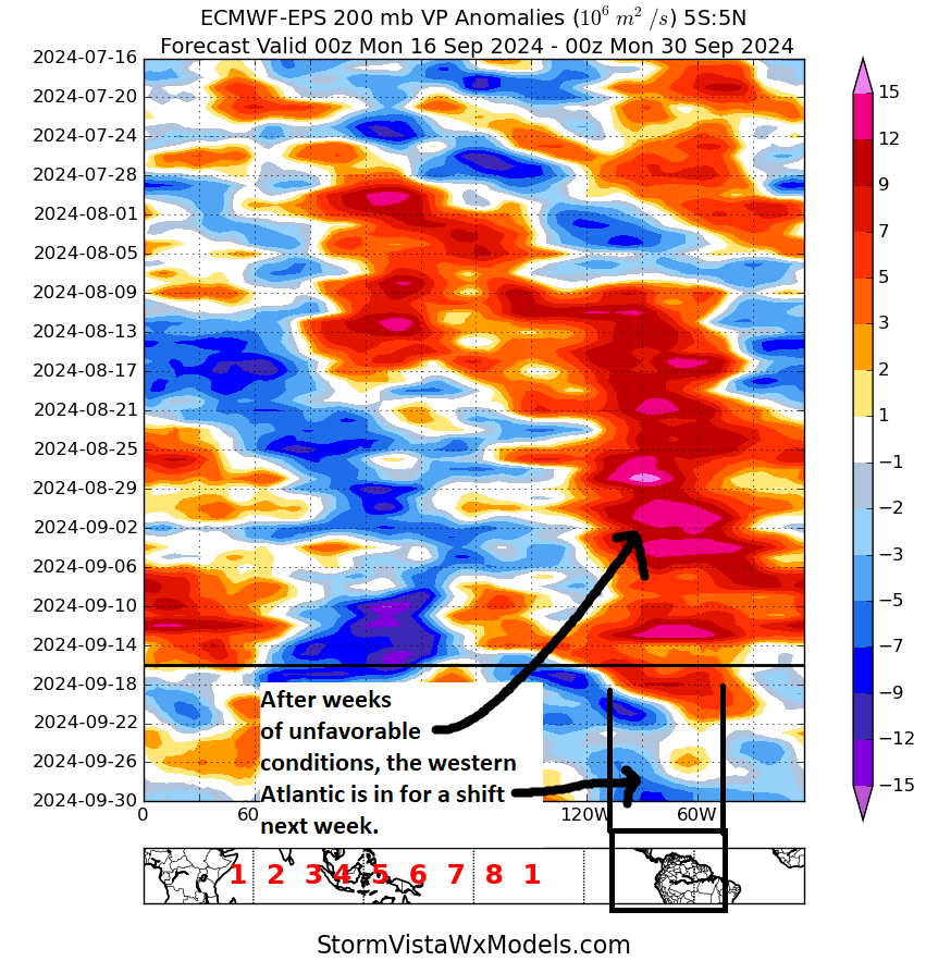
First off, we know that the overall atmosphere in the western Atlantic and Caribbean is going to become more hospitable to tropical development. After a period of hostile conditions that has basically been continuous since early August, the western Atlantic is going to flip to a more favorable background state for tropical development. In other words, less sinking air and more rising air will at least promote more development opportunities.
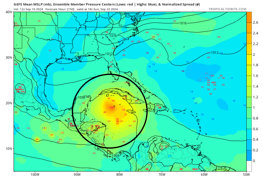
So the background state says that we should get moving. Second, we have seen signs in modeling of some type of either gyre scenario over Central America or the western Caribbean or some sort of disturbance that arrives there around early next week. This has been a feature in ensemble modeling for a while now, and it’s beginning to materialize in other modeling too as we get closer. But if you look at the GFS ensemble of sea-level pressures this coming Sunday, you can see a decent signal for low pressure in the northwest Caribbean.
This isn’t a flashing red lights signal but it’s enough for me right now. I’ll be watching this area closely. Exactly what happens from here remains to be seen, but we know that the environment will become increasingly hospitable, and this is some of the warmest water in the basin. It absolutely merits paying attention in the days ahead, whether or not anything ultimately occurs.
Do you think the high pressure system over us will still be in place through next weekend, like through the 30th of Sep?
too far out in time to determine accurate timeline of high pressure for now. best to check this weekend
We were supposed to spend this Saturday-next Friday in Cancun but still have time to reschedule. How concerned should we be about the possible system hitting the western Caribbean? Thanks!!
Thank you.
How often do tropical systems originating in the Caribbean/ Gulf of Mexico produce hurricanes? From reading this site casually the last few months, it seems that most hurricanes and tropical storms originate from systems of the coast of Africa. Is this typical? Do storms off the coast of Africa have more “runway” that those in the Caribbean/ Gulf, which gives them more time to develop into full fledged hurricanes?
Thank you for the posts and consistent reliable information.
Can you explain why exactly this wasn’t classified as a Tropical Storm? Wind gusts as high as 77mph but were the sustained below 39? Or does it have more to do with the circulation or some other thing missing