Headlines
- Beryl has intensified into a major hurricane and will move into the Windward Islands tonight
- This hurricane will likely cause significant damage to these small islands, including Grenada and Barbados
- Beryl will then approach Jamaica by Wednesday, where it is likely (although not certainly) to remain a major hurricane
- By late this week the hurricane should near the Yucatan Peninsula
- It remains an open question as to where Beryl goes beyond that, although a northwesterly turn into the Gulf of Mexico is a slight possibility
- Invest 96L could bring more misery to areas already impacted by Beryl
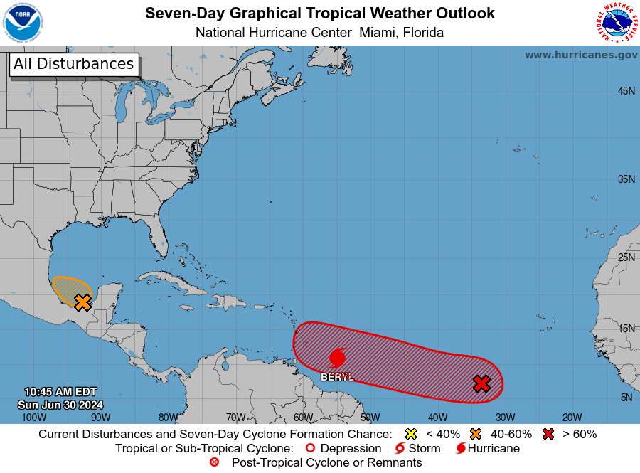
State of the Tropics on Sunday
As of late morning on Sunday, the tropical Atlantic remains very active for the end of June. In addition to Beryl, there are a couple of systems the National Hurricane Center is monitoring for potential development. We’ll comment on those at the end of this post, but our primary focus today is the rapidly developing Beryl, which as of 11:35 am ET is a dangerous Category 4 hurricane.
Hurricane Beryl this week
Thanks to warm seas, the system has intensified during the last 24 hours from a 50-mph tropical storm into a powerful 130-mph hurricane as it nears the Windward Islands. It should then cross these islands on Monday and move into the Caribbean Sea. The storm will likely remain sufficiently south of Puerto Rico and Hispaniola to preclude serious damage there, but it could threaten Jamaica on Wednesday and Central America and the Yucatan Peninsula toward the end of the week. After that? Movement into the Gulf of Mexico is possible, but after this point our confidence starts to decrease.
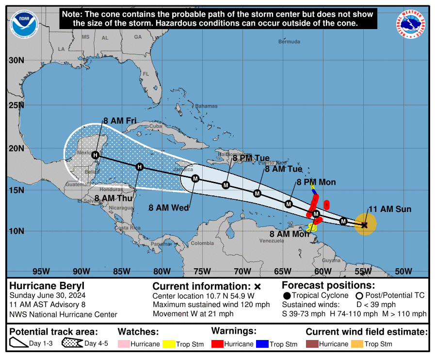
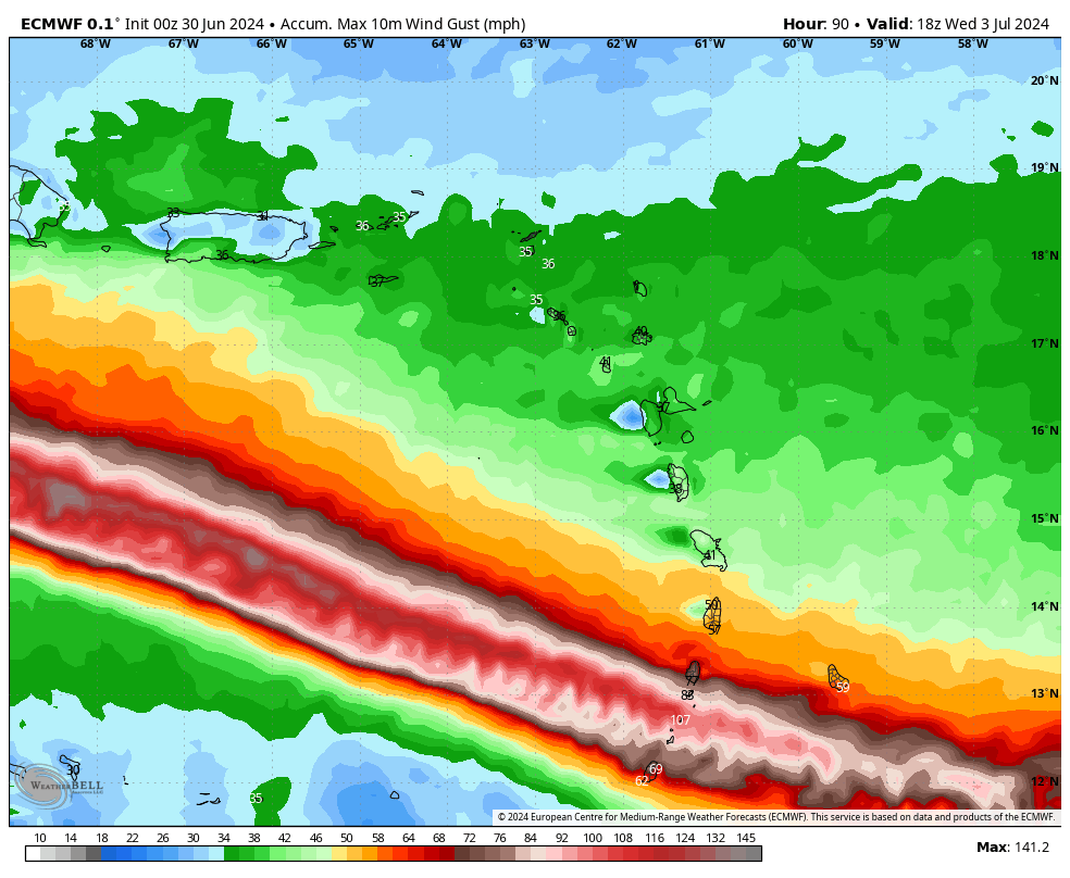
In terms of intensity, additional strengthening of Beryl is likely over the next 24 hours or so as Beryl traverses very warm seas and is encountering relatively little wind shear. The National Hurricane Center forecasts a peak strength of 140 mph sustained winds by Monday morning, when the storm passes near islands including Grenada, Barbados, St. Lucia, and Martinique. These locations should prepare for the most intense wind and surge impacts beginning after midnight tonight, and lasting through at least Monday morning. Localized rain totals of 6 to 12 inches are possible. This is a very serious situation, and residents should prepare accordingly.
As it moves into the Caribbean Sea on Monday and Tuesday, Beryl should encounter moderately stronger wind shear, and this probably will cause some weakening. But the jury is very much out on how much weakening will occur before Beryl approaches Jamaica on Wednesday. The National Hurricane Center forecasts the system having sustained winds of 120 mph at that time, but this is just a reasonable guess. By Thursday night or Friday, as the center approaches Belize and the Yucatan Peninsula of Mexico, it’s likely that Beryl will weaken a little bit further. It will still likely bring hurricane-force winds to these locations sometime between late Thursday night and Friday night, in addition to heavy rainfall.
Hurricane Beryl this weekend
Our certainty about Beryl’s track begins to fade by the weekend. From now until then, a fairly strong high pressure system should continue to push the storm westward. Over the weekend and into early next week, it is possible this ridge continues to steer Beryl westward into the Bay of Campeche. (It is not clear how much interaction with the Yucatan would disrupt Beryl’s circulation, but some weakening is virtually certain). In this scenario, Beryl is likely to move across the southern Gulf of Mexico and plow into the east coast of the Mexican mainland, similar to Tropical Storm Alberto about 10 days ago.
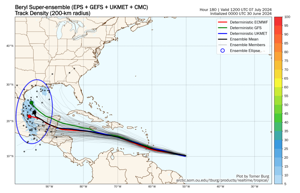
However, there is also the possibility that this ridge weakens, somewhat. At this point, this remains a lesser likelihood when we look at the global models. Still, there is a non-zero chance that Beryl turns northwestward after encountering the Yucatan Peninsula. In such a scenario a tropical system—be it a tropical storm or hurricane—could come to the Texas or even Louisiana coast late next weekend. I understand that everyone would like to have absolute answers about whether this will happen, but we just don’t have that kind of certainty right now.
Bottom line: It’s within the realm of probability, but the odds are fairly low. We can see this distribution of possibilities when we look at the “super ensemble” track of forecasts for Beryl, which favors the ridge holding strong. We should know more about this part of Beryl’s forecast by Monday or Tuesday, and of course we’ll remain on top of that at The Eyewall.
Invest 94L
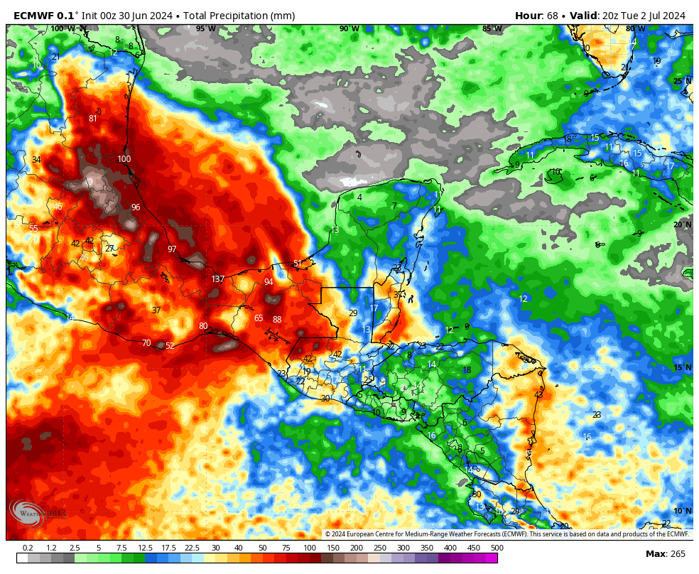
There is still a short window for this tropical disturbance over the southern Gulf of Mexico to develop on Sunday before it likely moves inland into Mexico on Monday. The primary threat from Invest 94L is heavy rains in southern Mexico and Central America, which saw similar impacts from Alberto just 10 days ago. Regardless of whether this system develops further or not, the effects will be the same.
Invest 96L
The third area of tropical interest is trailing Hurricane Beryl by a few days as it traverses the open Atlantic Ocean. The National Hurricane Center gives this system a 70 percent chance of becoming a tropical depression or storm during the next week, and at this point it seems likely to impact the Windwards Islands in a similar location. This could happen as soon as Wednesday, and could deliver an awful second whammy.
However, I have some questions about how much Beryl will perturb the ocean and atmosphere, and this could help to mitigate the strengthening of this tropical disturbance as it nears the Caribbean Sea in a couple of days. We will be keeping a close eye on the system, in any case.
I have always wondered if the cooling effect of hurricane generated rainfall, convection, etc has any effect at all on ocean temperature. If so, is that effect in any way durable, or is it transient?
It does! Often after a hurricane passes, you can see a “cold wake” in the temperature maps over the oceans. It typically only lasts a week or so before it fills back in, but it certainly doesn’t hurt.
Really appreciate how carefully calibrated you set expectations for what you tell us.
Beryl at Category 4 this morning is pretty stunning. That has to be breaking some records, especially for that far East…
We try! Thanks for reading.
Thank you for the no hype, again thank you for the update, now enjoy your Sunday.
Thank you. I am glad that you do this even though you have a day job. You are appreciated.
I prefer to skip all the speculation and go straight to panic. It keeps my hurricane anxiety happy
Why does the nhc list it as 120 mph? IDGI.
Believe you are reading the winds in knots, 120 kt, which equals 140 mph. Take a closer look. It is easy to miss the defining unit of wind speed.
The family is supposed to head to Grand Cayman on Tuesday for our summer vacation. It looks to be tracking south at the moment. What do you think from a storm/storm surge perspective?
https://www.weather.gov/forecast
It will be a different storm then, but one you should continue to monitor closely. I would get in touch with your hotel and perhaps discuss what they’d suggest.
Assuming a landfall in Mexico, what kind of storm surge should expect around Surfside and Galveston?
If that were to happen (a big if), a lot would depend on the size of the circulation around it. Right now, it doesn’t appear it would be as large in scale of wind as Alberto, so if it took the same track, all else equal, surge would be less than that. However, if it comes in farther north, closer to Brownsville or Corpus, that obviously changes things a bit. Still too soon to say much more.
So many factors to determine that kind of info right now since its no where near TX right now
If the tropics are this active in JUNE, how will they look at the peak of hurricane season? Oh boy. 😬