In brief: Near-record flooding is ongoing or forecast to occur north and east of Seattle today, tonight, and tomorrow leading to dire warnings in a few locations in western Washington. Another round of precipitation is likely next week, but the hope is that temperatures will cool off some, lowering snow levels and mitigating another wave of flooding concerns. Also below, we talk about record cold in the Midwest this weekend, and follow-up warmth in the run up to Christmas.
Pacific Northwest flooding focus
Let’s get caught up on the flooding in Washington State, where both the Snohomish and Skagit Rivers are going ballistic.
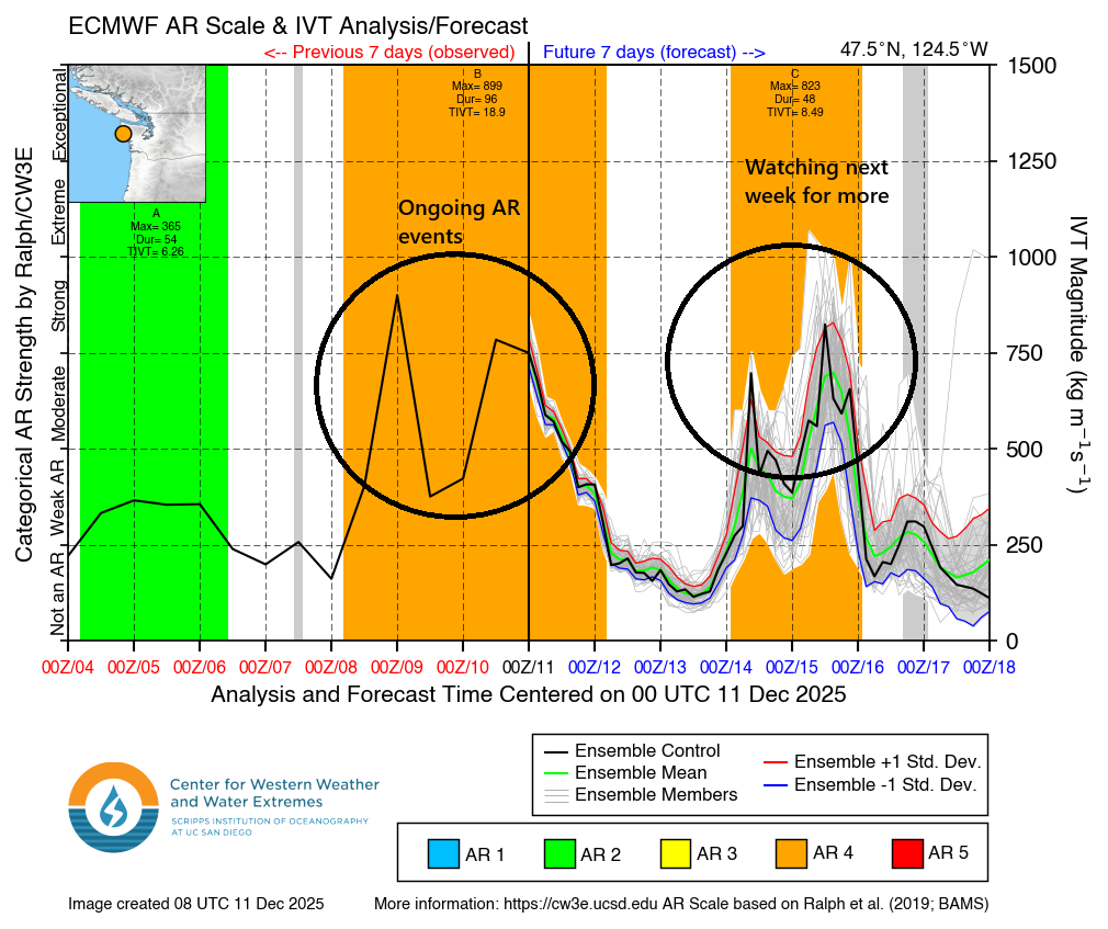
Check this video out from Snoqualmie Falls last night. Wild. This is not a typical Pacific Northwest rain. High snow levels and a double-barreled, prolonged category 4 atmospheric river event have triggered some extreme flooding concerns in the region.
Rainfall over the past 72 hours has been quite extreme in the mountains, and much of the concern right now is because it’s so mild. The low temperature in Seattle yesterday was 53 degrees, a record warm low for the date, and only 3 degrees shy of the warmest December low temperature on record there. Snow levels have been up around 5,000 feet or higher in spots.
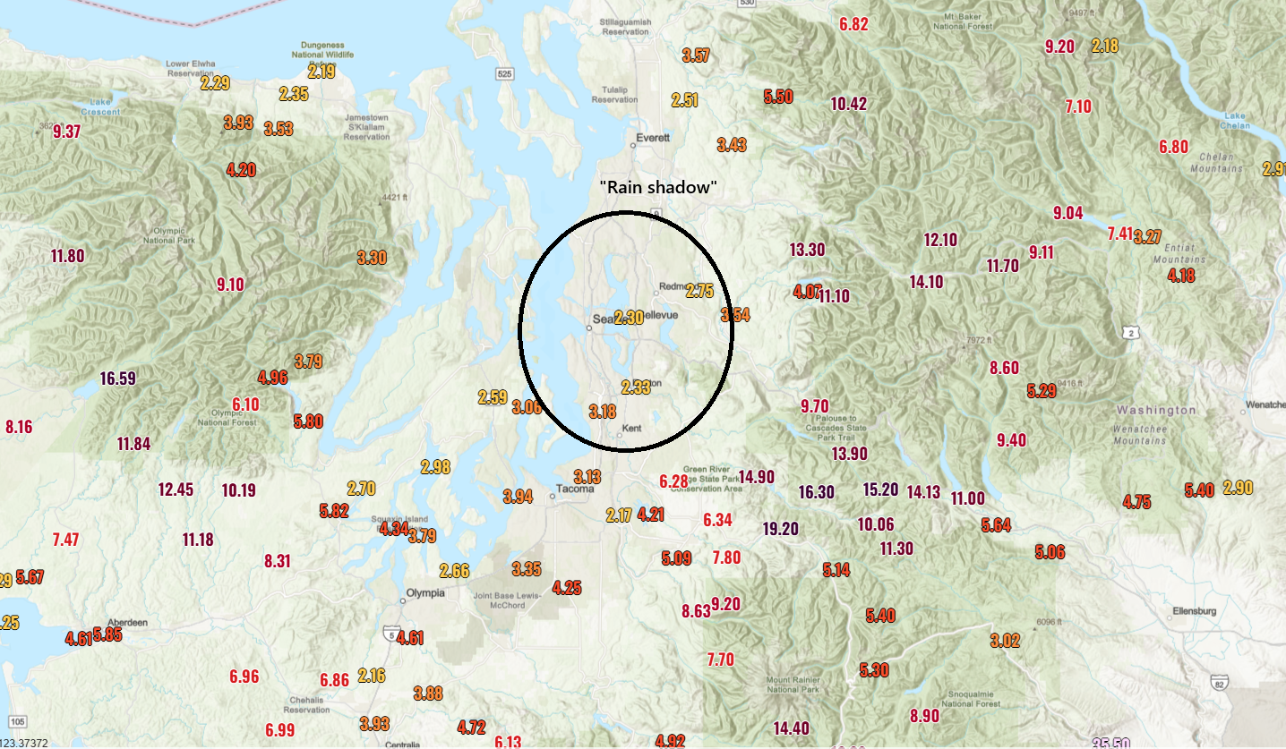
You can look at the map above and see a couple things. First, some of the mountains have seen north of 15 inches of liquid in the last 72 hours. 19 inches of liquid at the Lynn Lake SNOTEL site, all of it rain. Second, you can clearly see an Olympic rain shadow over the Seattle metro, which has spared the city of Seattle at least any real severe issues. However, all this water in the mountains? It has to go somewhere.
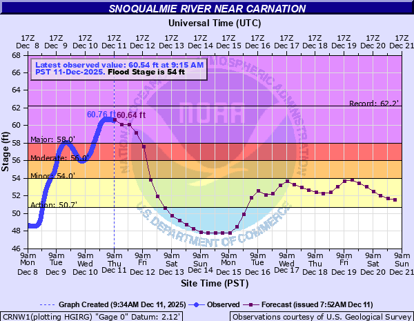
The Snoqualmie Falls video above is wild, and the water coming over the falls peaked around 70,000 cubic feet per second (cfs) last night, shy of the 78,000 cfs record. The river level was around 20 feet, which is just shy of the top 3 from 1990, 2006, and 2009. Downstream, the river peaked about 1.5 feet shy of the record at Carnation.
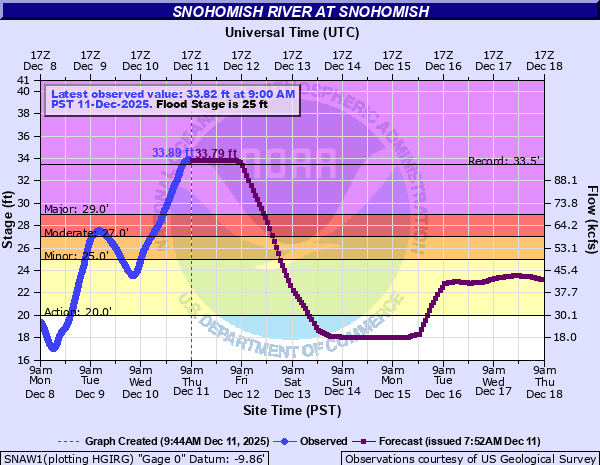
Meanwhile, on the Snohomish River at Monroe, a record crest is expected later today.
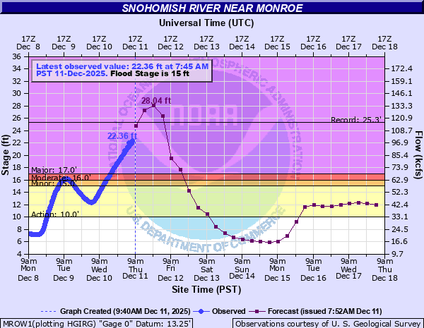
The current forecast has it cresting about 3 feet above the record later today, but the current observed levels are running probably just shy of that pace. Either way, it will be near or above the record when it crests. At Snohomish, the river has established a new preliminary record crest of 33.89 feet, besting the 33.5 feet set in the 1990 flood.
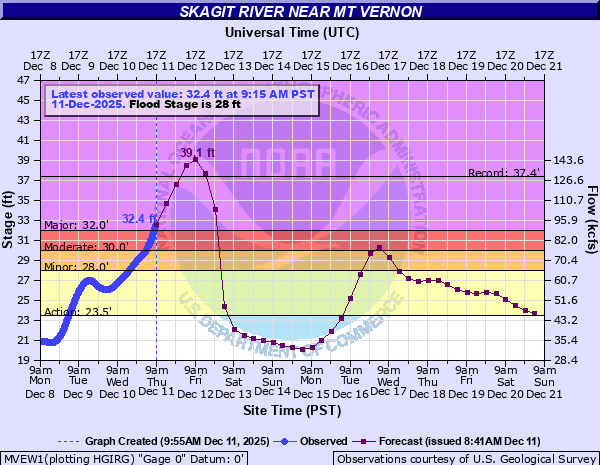
To the north, the Skagit River should crest a couple feet above its record levels. This forecast is lower than yesterday but still pretty catastrophic for this region. At Mount Vernon, we’re looking at around a 39 foot crest, compared to the record of 37.4 feet, also from 1990.
To the south, the Cedar River at Renton will also probably set a record tomorrow morning, when it reaches north of 17 feet.
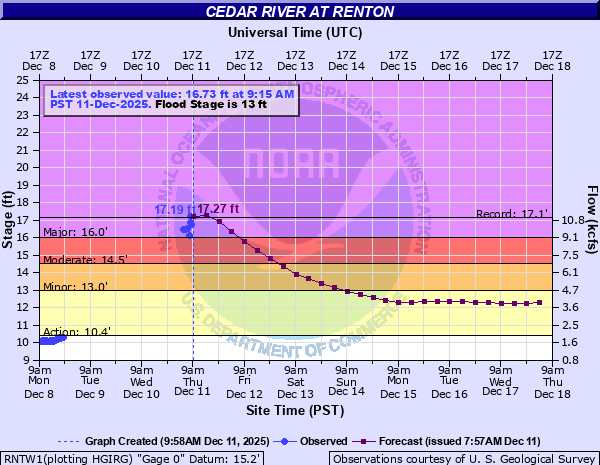
That river’s record? Also from 1990.As noted in this morning’s hydrologic discussion for the area, inundation near the rivers between Everett and Mt. Vernon is likely, and the threat of landslides remains as well.
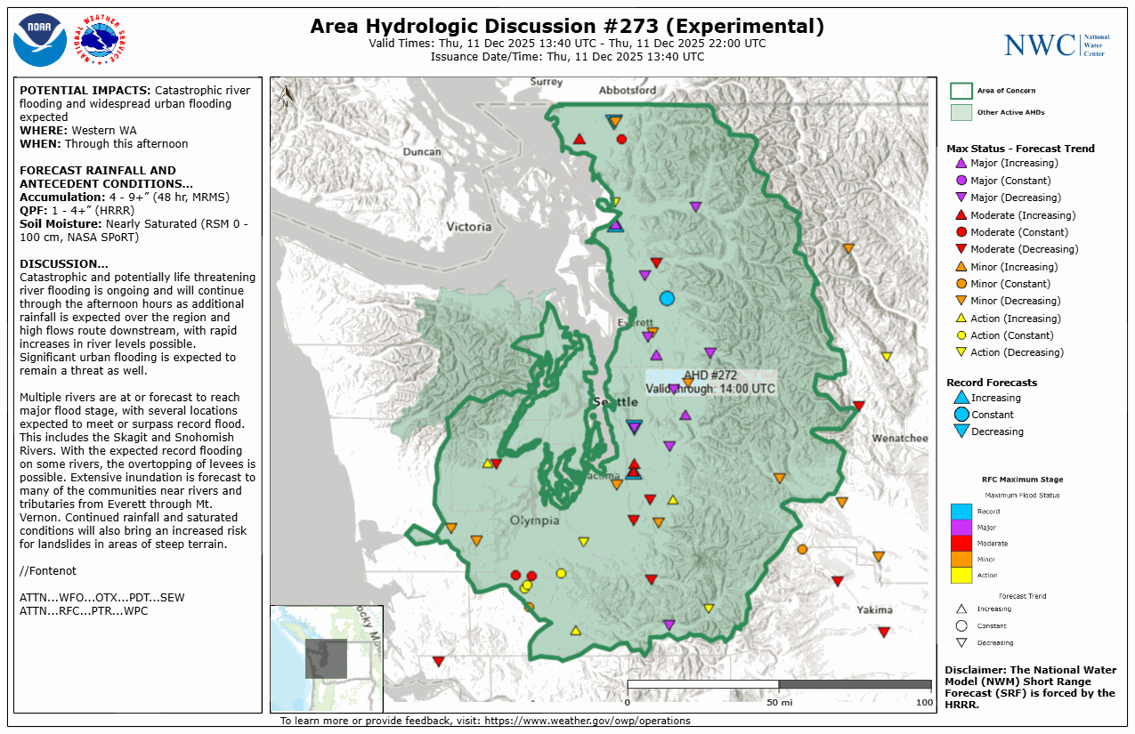
In addition, the NWS in Seattle has issued a flash flood watch for the Skagit River below Sedro-Wooley for dam and levee failure risk through Friday night.
Bottom line, it’s a mess, not everywhere but over a wide swath of northwestern Washington State. Flood warnings are also in place in parts of northern Idaho and Montana as well.
As things settle down tomorrow and Saturday, our attention will shift to the next AR event, which looks poised to crash ashore beginning on Monday or Tuesday. This one will start quite warm as well, but fortunately it does look like temperatures will drop off a good 5 to 10 degrees compared to the ongoing event. This should lower snow levels down to more typical elevations and lead to less of a full-scale runoff event like the ongoing one. Still, we will probably be looking at a fair bit of precipitation from this event.
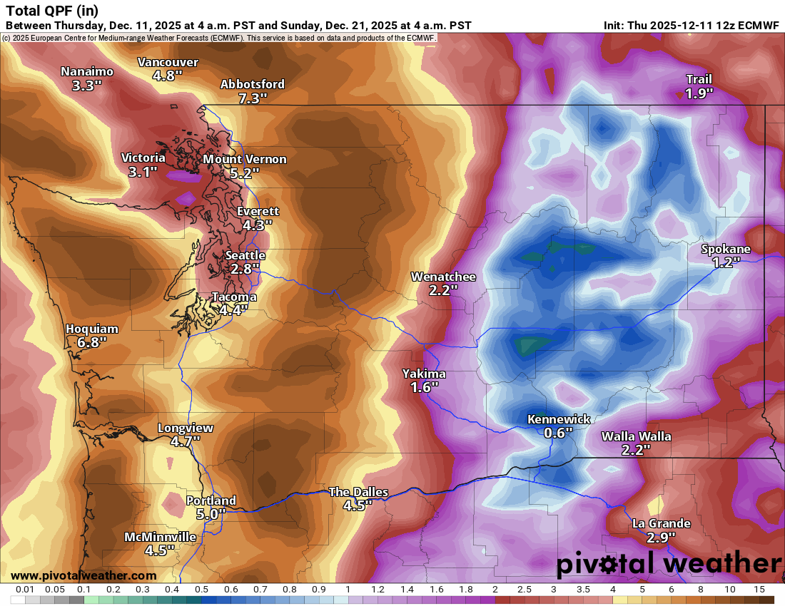
Liquid equivalents will be on the order 10 to 13 inches in the Cascades next week, or as it stands now at least. While the amount of water flowing into the river systems will be mitigated by the snow that accumulates and sticks around, we will probably see another round of (less extreme) flooding risks next week in the Northwest.
Near record cold
Meanwhile, as this whole pattern evolves, we get one last real serious shot of cold in the Eastern U.S. this weekend, peaking on Sunday. This one will probably be the coldest we’ve seen this winter across the Midwest, with numerous record lows being threatened on Sunday morning.
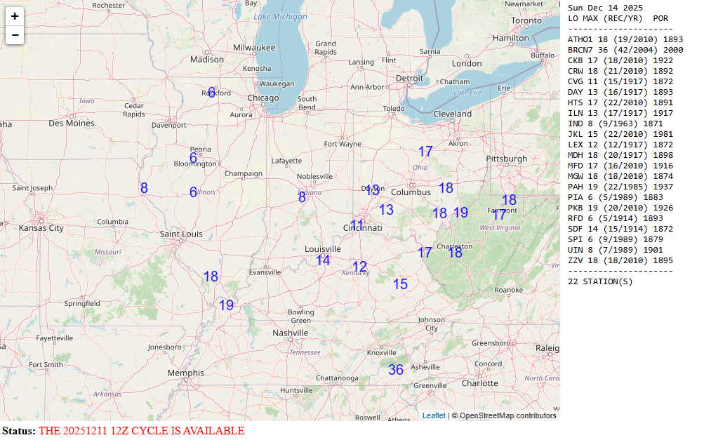
Forecast lows will be near 8 degrees in Indianapolis, 14 in Louisville, 11 in Cincinnati, and 13 degrees in Dayton. Wind chills of -10 to -20 will be widespread in the Midwest with -30s in Minnesota.
Back to warm
But thereafter, the pattern changes again. The 5-day average 500 mb height anomaly map is shown below for the period ending on Sunday evening, December 21st.
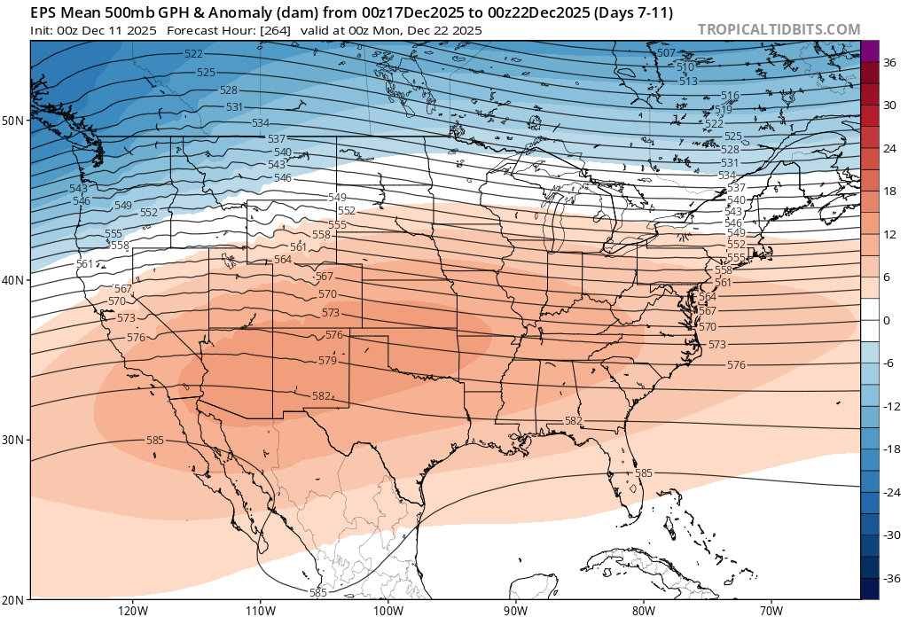
A very broad, very strong ridge of high pressure will setup across the Southwest and Plains. This may be close to record strength for this late in the calendar year. That would translate to high temperatures, possibly numerous record highs and record warm minimum temperatures across the country in the days before Christmas. For cold, you may only be able to look to New England, the Pacific Northwest, and the extreme Upper Midwest. Stay tuned.