Headlines
- Quiet tropics are expected to continue into the end of July.
- Some signs of a potential tropical wave to monitor in the western Atlantic in early August.
- More activity is expected to pick up in mid to late August.
Calm continues a little longer
The tropics continue to look pretty quiet over the next week or so, with no areas worth watching at this time.
Calendar flips into more action?
As we head into August, as we’ve been warning, it does look like the dam will begin to break, slowly at first but with perhaps more voracity as August progresses.
Yesterday afternoon’s week 2 and 3 outlook from the Climate Prediction Center do highlight the Atlantic for tropical potential north of 20 percent.
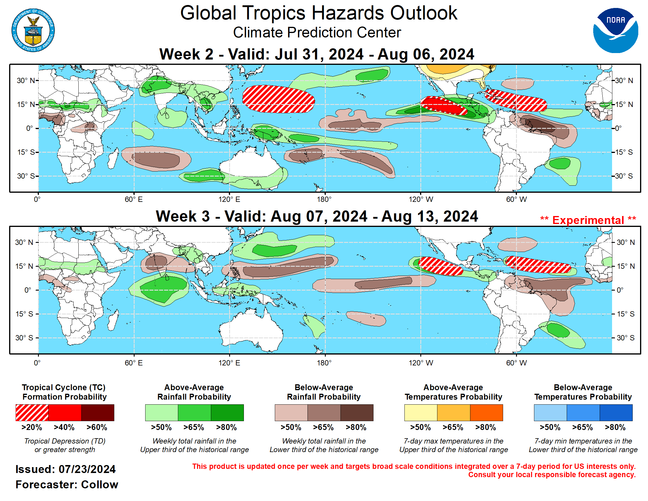
This makes sense on a couple levels. As we noted the other day, it does look like a more favorable “background state” is on the way to the Atlantic basin. Additionally, there is some “buzz” in the modeling looking toward the Bahamas late next week or weekend. The Euro has been on this one for a bit, with the operational model guidance periodically showing something, including at midday today. The ensemble guidance is much less enthusiastic about this, as you can see from the 00z European EPS looking at the IQR difference map from Tomer Burg’s excellent site.
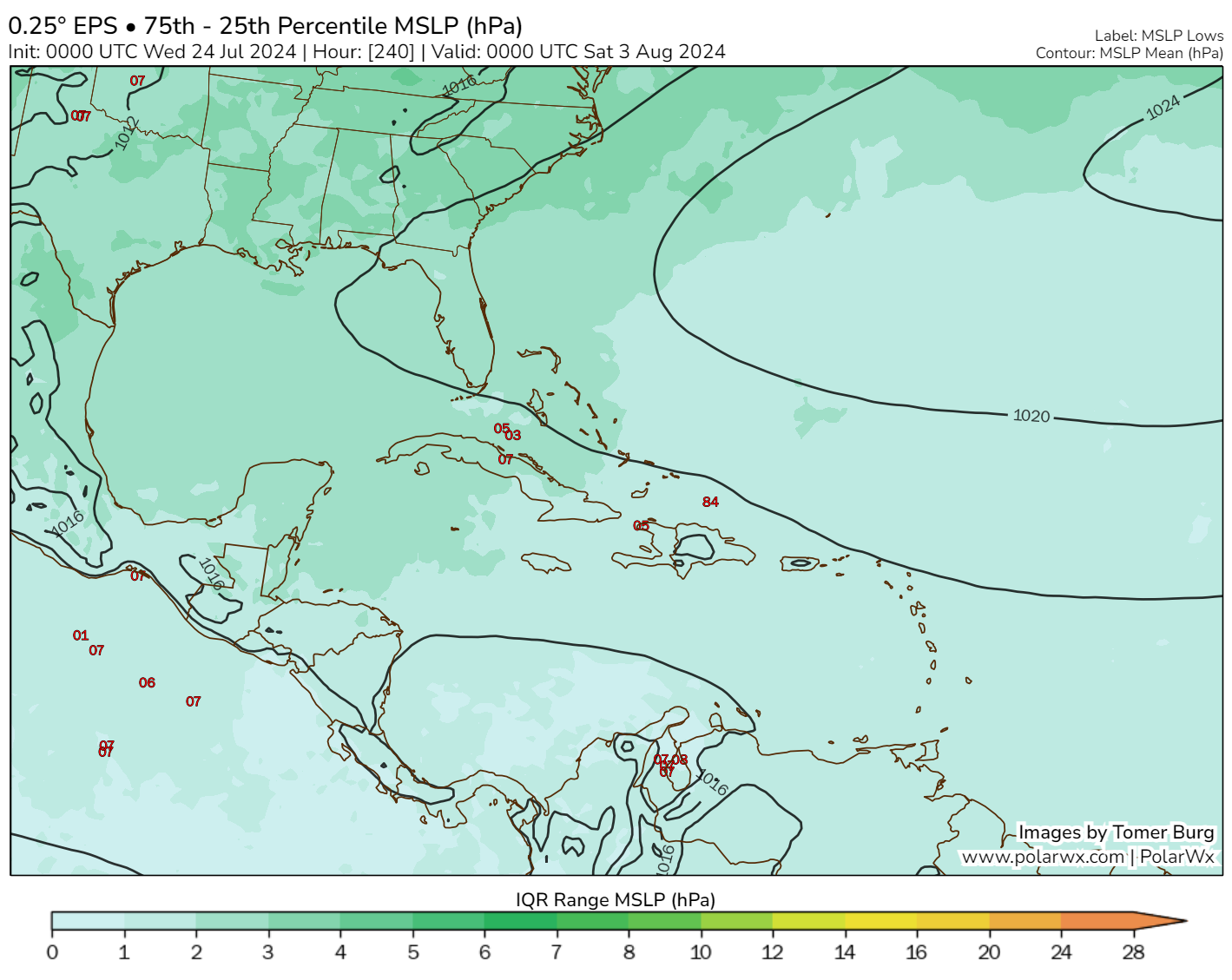
This really lacks much support from elsewhere at this time. The GFS and its ensemble generally shows little in this region. Even the ICON (for now), which tends to overforecast in the tropics but nailed Beryl in the Gulf doesn’t have a particularly strong signal. That said, wind shear looks relatively modest next week. However, dry air may be in plentiful supply around the area with significant dust in the basin right now, which would limit development. I would say that I can understand modeling picking up on this area for possible development, but I do not necessarily think this merits significant concern at the moment. We’ve got some time, so let’s continue to watch for an uptick in showers and storms in the Bahamas late next week or weekend.
Elsewhere, we continue to see hints of more aggressive change later in August, with European weekly data now showing above normal tropical activity by late month. Not much else we can say at this point, except to make sure you’ve got your season preps complete or soon to be completed as we white knuckle our way into later August.
Many of us will be wanting the high pressure dome of doom over us by then. Especially so with as much rain as SE Texas has been getting.
I’d certainly be happy for one to park over us till through the Fall. Seemed pretty effective last year.
There were other factors that prevented tropical systems from getting close to TX that we won’t have this year such as el nino enhanced wind shear and a weak bermuda high that curved storms north or east out to sea
Ok, well thanks for clarifying everything for everyone tina wow
Tell Centerpoint to do the same thing dammit……
I read yesterday that a quiet Pacific hurricane season has a rebound effect on the Atlantic. That an imbalance of quiet in the Pacific could translate into an overabundance of activity in the MDR. Do you think this could be the case?
I’m gueessing this doesn’t translate well for the BOC & GOM either.
Correct…that is how it generally works. The tropics tend to have a kind of see saw effect in our hemisphere…one goes up, one comes down and vice versa.