In brief: Travel on Wednesday doesn’t look too bad, but some strong winds in the Midwest or Great Lakes may be a hassle. Lake effect snow cranks up in the Lakes this week as well. After Thanksgiving, the forecast grows uncertain, with a lot of hype around cold that may or may not happen. In our newsy bits section, flood issues in New York City, massive protests in the Philippines due to flood mitigation corruption, and a visit to Hill Country 4 months after the tragic floods.
Pre-Thanksgiving travel
Let’s get you caught up on Thanksgiving travel risks for Wednesday across the country. A significant winter storm will track eastward tomorrow with heavy snow from the Northern Plains through Upper Midwest and into the Great Lakes. By Wednesday. the morning forecast map shows a cold front exiting the Eastern Seaboard with some lingering showers perhaps on the East Coast. A strong storm will be cranking over the Great Lakes or Ontario, which should rev up the lake effect snow machine in parts of Michigan and eventually east of there.
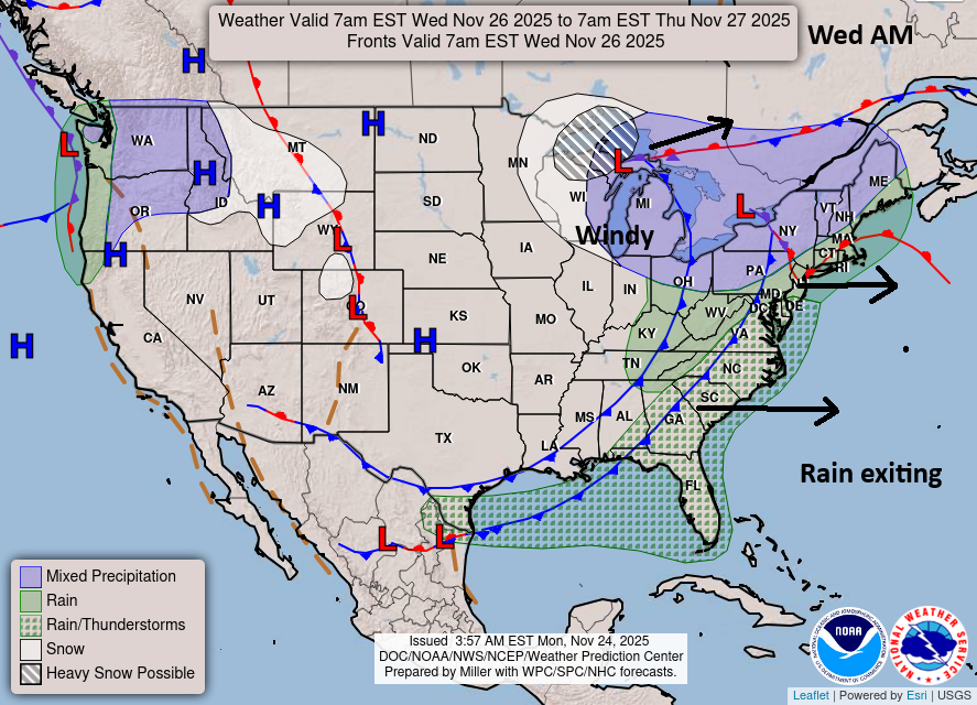
But from a travel perspective, the biggest issues will be that snow in northern Michigan and U.P., as well as perhaps some wraparound snow in Wisconsin. Strong winds may impact some flights in Chicago, Milwaukee, Indianapolis, Minneapolis, or Detroit. A few showers and storms are possible across Florida. Thankfully, the Northeast airports, Atlanta, Dallas, Houston, and most of the West Coast look fine. Hopefully this keeps delays and travel headaches to a minimum. For the most part, travel TO most destinations by air or car will be fine outside of those handful of areas.
Lake effect snow machine
Heavy lake effect snow is possible in the traditional snow belts off the Great Lakes after Tuesday night and Wednesday morning.
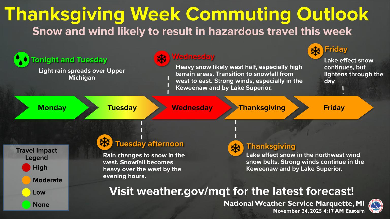
Snow will crank in northern Michigan and the U.P. on Wednesday with northwest winds keeping the snow going in those snowbelts Thursday and Friday. Off Erie and Ontario, from Wednesday night through Friday we’ll see lake effect snow pick up as well, mostly well south of Buffalo toward Erie, PA and on the Tug Hill Plateau north of Syracuse and Utica.
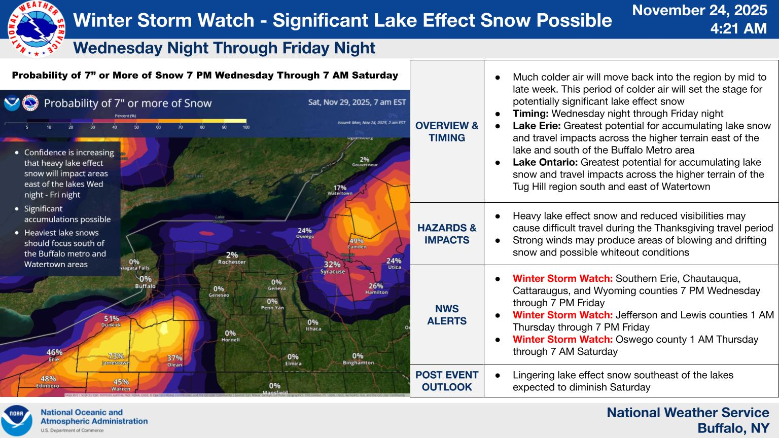
This doesn’t look like an epic lake snow event, but there will be some healthy totals surely, and holiday travel on Thursday or Black Friday travel may be impacted by the lake effect snow.
Post-Thanksgiving travel & cold?
It does appear that an active weather pattern will resume this coming weekend into next week. It’s a bit tough to pin down the exact track and impacts of any one storm system, but some sort of broad impacts from rain and perhaps a wintry mix will be possible Saturday into Sunday. Return travel may be impacted by this storm system, though again it doesn’t look too crazy right now.
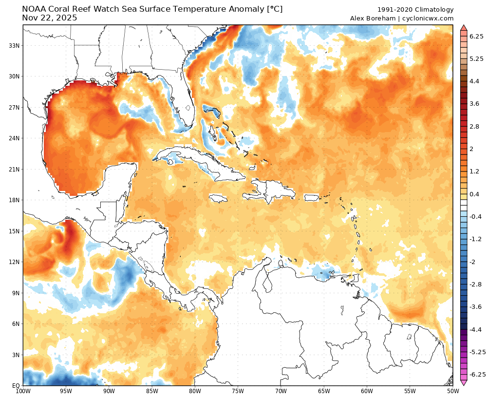
Cold air does look to follow this into the Central and Eastern U.S. eventually. But models continue to oscillate around on potential intensity and trajectory of the cold leaving a good deal of uncertainty. I’ve seen some pretty heady comparisons floating around with the early December cold, and those seem outright hyperbolic right now. Models cannot resolve things after this weekend in terms of how this is going to setup, so it would be wise to not assume anything about mid to late next week. Gulf of Mexico water temperatures are as warm as they’ve ever been this late in the year.
Couple that with the seasonal resistance of a Southeast ridge that will likely be aided by these warm waters, as well as a distinct lack of snowpack over the Central Plains, and you can bet any cold air mass will modify a lot by the time it gets across the country.
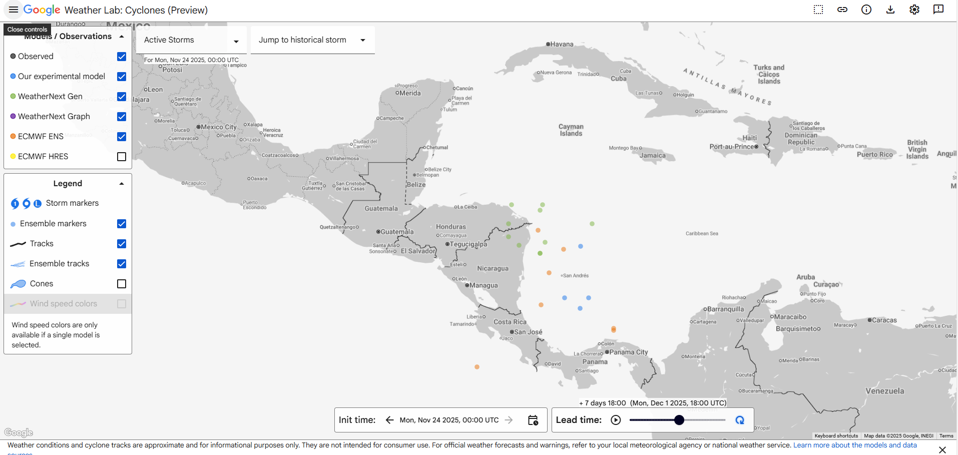
Speaking of warm water, some models are trying to spin up a tropical system in the southwest Caribbean next week. This is unlikely to happen, but the chances are better than just writing off the GFS operational model as totally out to lunch. Seasonally, there’s a metric ton of wind shear around, which likely severely caps any storm system that tries to develop. However, a minority of ensemble members from Google Deep Mind’s suite does show this possibility.
If something were to develop, expect it to be weak and sloppy like the Thanksgiving dinner guest you were on the fence about inviting that has no decorum.
Newsy bits
Closing out today with some newsy bits from the various articles I’ve been opening in my tabs.
Texas: I want to start with this piece by Alan Gerard from last week that takes another look at the flooding in Texas. There’s a lot to unpack here so I suggest you read the piece yourself. So many issues are involved with this, and so much remains left to be discussed. Alan does a good job taking stock of things from ground zero, as he had a chance to visit Kerrville recently. Worth your time. (Balanced Weather)
Philippines: One issue we see time and time again around the world is corruption rearing its head when it comes to government projects. We know this is a problem at times in the U.S. And in some ways, I worry we’ve become apathetic to things. Well, in the Philippines, they’ve had enough. A recent protest in Manila attracted an estimated 650,000 people, as billions of dollars in flood mitigation funds have apparently ended up lining the pockets of company owners, government officials, and parliament members. This is a huge issue, and the group organizing it is incredibly influential in that country’s politics. Stay tuned. (The Guardian, Al Jazeera)
Southern California: After last year, the specter of a bad fire season in California certainly had people nervous. Fortunately, at least in central and southern California, the current fire season is likely over. (LAist)
Arapahoe Basin: Ever wondered how ski resorts “make” snow? Here’s an inside look at how it’s done in Arapahoe Basin. (Summit Daily)
Athens County, Ohio: Athens County, Ohio is working on a thorough project to map flooding patterns in the county thanks to a recent grant. The goal is to take the knowledge gained from the mapping to recommend and apply nature-based flooding solutions to help mitigate future flooding in the region. (The Ohio Newsroom)
New York City: A well put together piece here describes some of the challenges and possible solutions for New York City in a world of higher tides, increasing rainfall, and increasing storm surge risk. (New York Times) A $218 million project in Brooklyn, specifically Red Hook may fall short of what is needed to help reduce flooding in that neighborhood. (NY Amsterdam News) Meanwhile, in Queens, a community impacted by Sandy feels neglected and forgotten. (The Guardian)