In brief: Despite the blizzard and cold weather in the Northeast lately, it’s been mostly warm across the country, with some serious warmth this week as well. A much more active pattern will establish over the middle of the country, including in Texas where heavy rain and severe weather are possible later this week.
Happy Monday, folks. We are now in the throes of meteorological spring. Why the difference between meteorological spring (Mar 1-May 31) and astronomical spring (Mar 20-Jun 21)? Convenience, mostly. And consistency. Astronomical seasons don’t always follow the same dates each year, though they’re fairly close, as they’re tied to the Earth’s tilt and the alignment of the sun over the Equator. So when you hear meteorologists talk about spring, we’re talking about the months of March, April, and May.
And to that end, it has felt like deep spring across much of the country. Over the last week, over 2,000 warm temperature records (max and min) have been set compared to 275 cold records. Over the next 7 days, we have additional record warmth expected, perhaps peaking this Friday where dozens of warm temperature records may be set from the Great Lakes into the South.
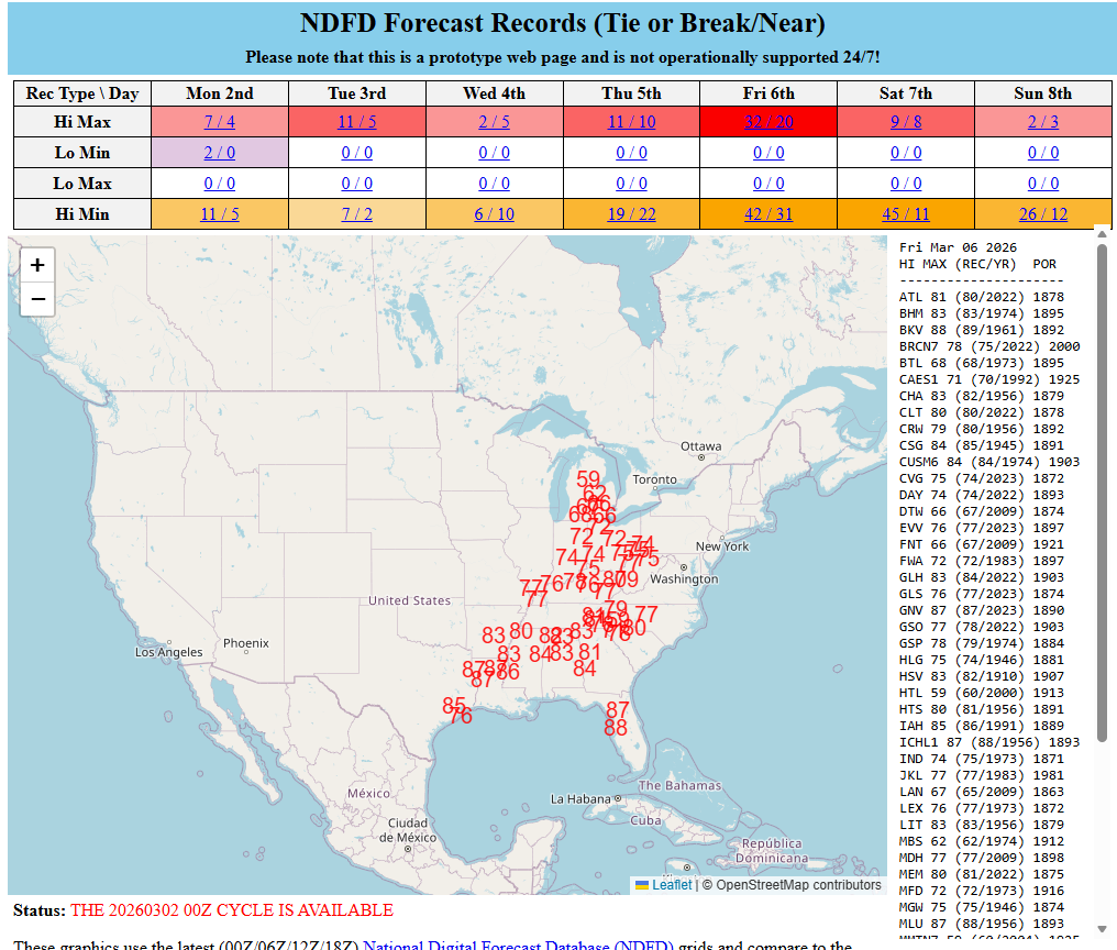
Most of the record highs are forecast pretty close to the current records for the date. Some of the record warm lows are already well above their records right now. For example, Binghamton, NY is forecast to be 45 degrees on Saturday morning compared to the record warm low of 39 degrees set in 1974. Detroit is forecast to be 51 on Saturday, compared to the record of 47 set in 2012. It takes a lot to forecast record temperatures that far in advance, but it’s going to be that sort of warm period this week. The only cool part of the country right now looks to be New England, and even that will disappear by midweek.
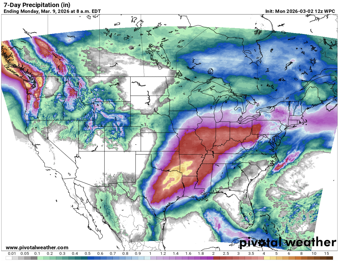
With warm air is going to come precipitation, and the potential exists for a healthy amount of it from Texas (more below) into the Mid-Mississippi Valley and Ohio Valley. Current rainfall forecasts over the next 7 days are anywhere from 2 to 5 inches across the region.
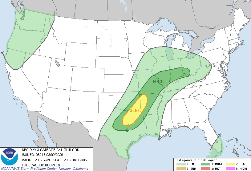
In addition, there will be some severe weather possible in the Central U.S., with a couple of days highlighted between North Texas and Missouri.
It appears that this active weather pattern is likely to persist beyond this week into next week as well, so prepare to start hearing about at least the risk of flooding eventually.
Texas weather this week
Focusing in on Texas, we know two things about this week: It will be a pattern change to stormy and will continue to be quite warm. Beyond that, we still have some questions to answer
Rainfall/Storms
First, over the course of the week, it will become increasingly stormy over parts of the state. Beginning Tuesday night, we could start to see a couple thunderstorms develop in the Panhandle and north-central plains of the state. Into Wednesday afternoon and evening, the chances of storms spread to the east, and parts of North Texas and East Texas are highlighted in severe weather risk for Wednesday.
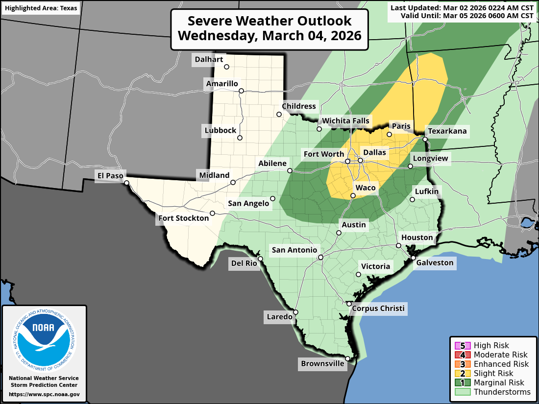
This includes the Metroplex. I wouldn’t be shocked to see a couple stronger storms just outside this highlighted area too, down into Hill Country. Additional rounds of storms should follow Thursday, with a focus drifting back into West Texas. Strong to severe storms may attempt to develop again on Friday in Central Texas up into North Texas.
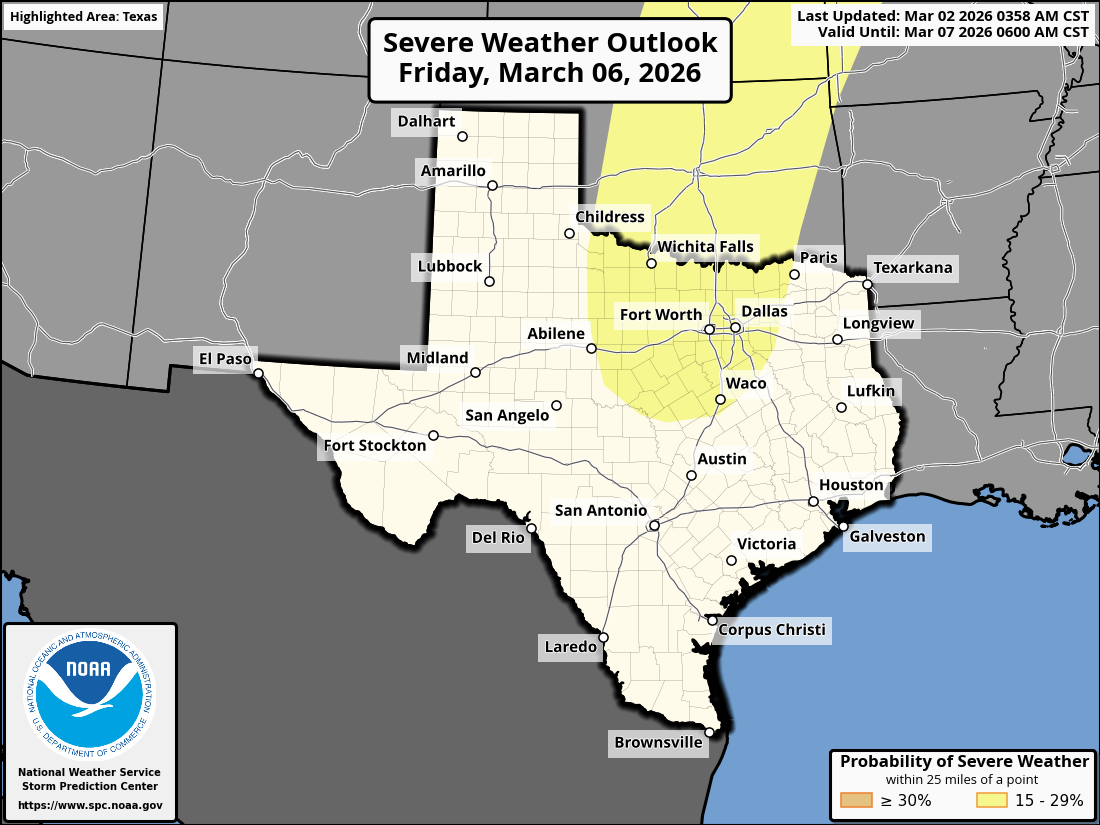
More numerous showers and thunderstorms may affect the area from the Permian Basin into northeast Texas on Saturday. Active weather should continue in much of the state after this, perhaps with the exception of El Paso and the Panhandle.
All told, total rainfall is going to vary widely across the state. Most areas outside of El Paso and the Big Bend and Panhandle should see at least a half-inch of rain. Areas from about Laredo and Del Rio northward into San Antonio, Austin, Waco, and Dallas should see at least 1 to 2 inches of rain. I would expect at least an inch on either side of that in Hill Country, the Piney Woods, and College Station through Victoria. Embedded within those areas of rain will be isolated higher amounts. Some places could easily see 5 or 6 inches of rain or even more before all is said done. Consider the map below an average for what to expect across the state.
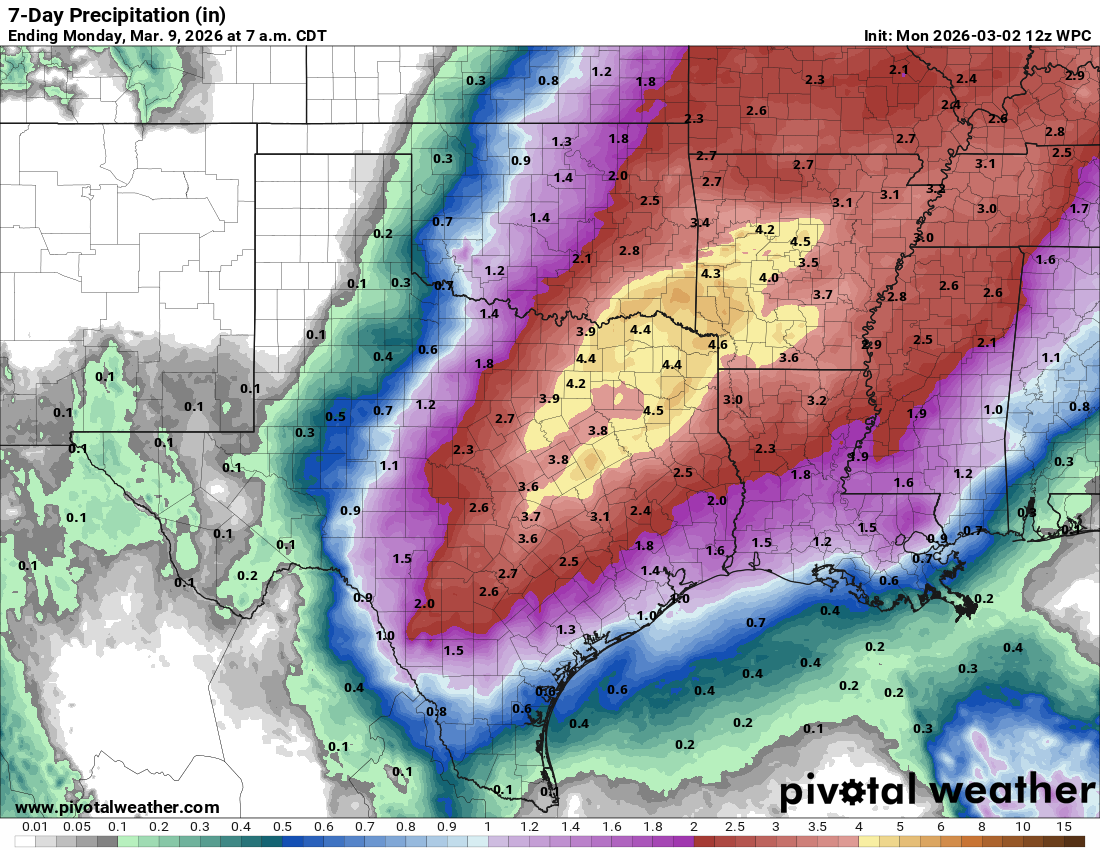
Currently, most of Texas is not highlighted in any WPC risks for flooding. That being said, we’ll almost certainly see a few areas of flash flooding pop up. There will be a healthy amount of atmospheric moisture available in the state from Wednesday through the weekend, so these storms should have little trouble tapping into the heavy rain potential if they align themselves appropriately. The state has been so dry lately though that most of this rain will be beneficial.
Temperatures
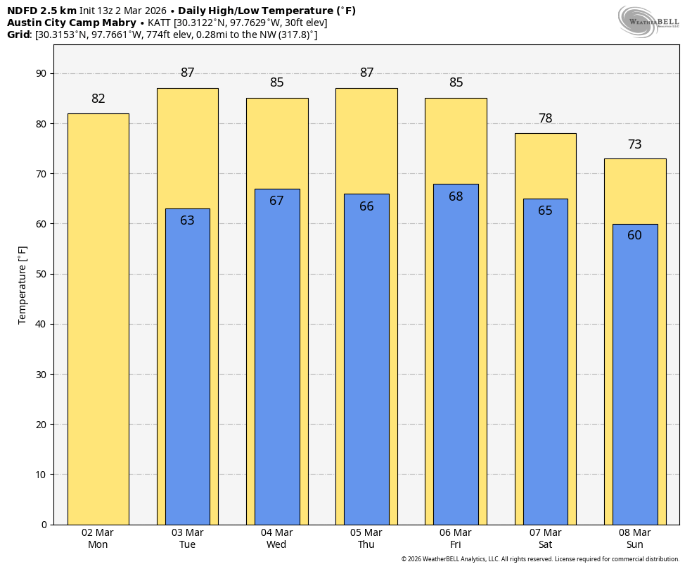
It’ll be quite the warm week across Texas, with highs expected to be in the mid-80s in Houston, low to mid-80s in Dallas, and mid to upper 80s in San Antonio and Austin. Temperatures will be a little bouncier in West Texas, with Wednesday and especially Saturday looking cooler.
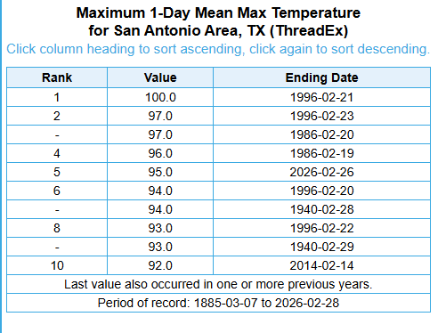
Last week’s hottest temperatures in the major Texas triangle cities were 86° on Friday in Houston, 84° in Dallas on Saturday, and 88° in Austin on Wednesday and Saturday. San Antonio wins the prize for first triangle city to 90 degrees, hitting 95° on Thursday. This was the 5th hottest temperature observed in winter in San Antonio going back to 1886.
Corpus Christi’s 95 degrees on Thursday was their third hottest winter day on record. Laredo’s 103° was the hottest winter temperature on record there, tying the mark hit in 2011 and 1986. A preliminary all-time U.S. hot record for winter was set on Thursday at Falcon Dam in the Valley at 106°. The data is preliminary and has to be vetted for accuracy before we can officially put in the books.
The hope is that some of this rain will reach drought-stricken parts of the state. South Texas needs it desperately.