In brief: Today’s update provides an overview of the dusty tropics and a look at a new seasonal forecast from Colorado State University. We also dig a little deeper into storms today in the Midwest, and the potential for excessive heat in the West.
Hi everyone, Eric Berger here. As you probably know Matt does the majority of forecasting on The Eyewall but I’m here to back him up, and so I pinch hit occasionally. This is the first time I’ve written for the site since we have moved our newsletter over to Substack, and I just wanted to thank everyone who has signed up. The response so far has been tremendous, and we are already making plans to improve The Eyewall as a result. But for now we are going to focus on hurricane season, heavy rains, and heat in today’s outlook.
The tropics
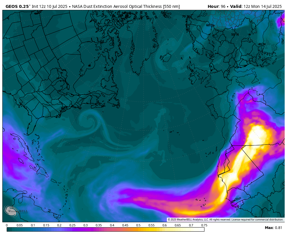
Let’s start in the tropics where, happily, everything is quiet all the way from the Central Pacific Ocean to the Eastern Atlantic. This is not all that abnormal for the first half of July, but it is nonetheless welcome. Looking ahead, due to a variety of factors including a new and fairly large plume of dust moving off the Sahara into the Atlantic, we think things will remain fairly quiet for at least a few more days—and hopefully more!
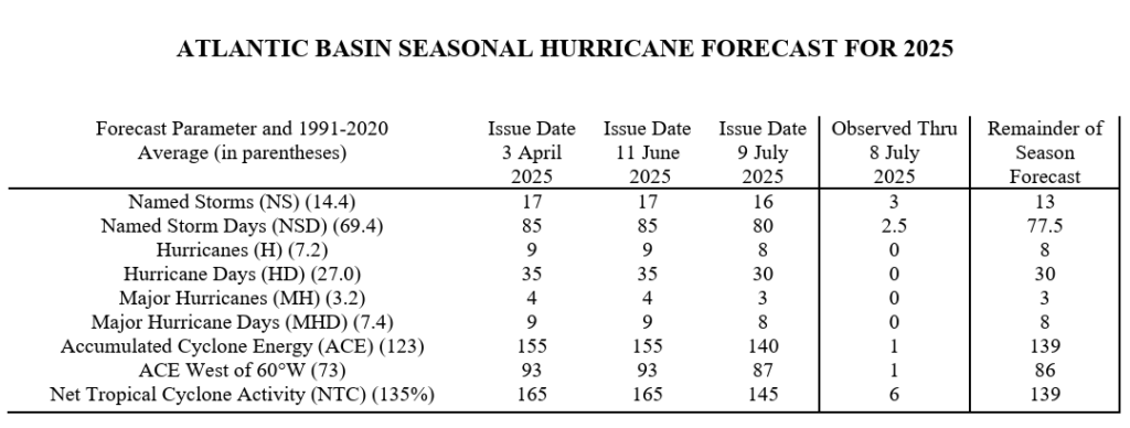
In this interim period of quiescence I wanted to take a peek at the updated seasonal hurricane forecast from Phil Klotzbach and his team at Colorado State University. As you can see in the chart below, the team has slightly lowered their outlook in terms of named storms and hurricanes, and reduced the overall forecast for Accumulated Cyclone Energy by 10 percent. This is only a slight modification, and given the inherent error within seasonal forecasts such a change does not mean a whole lot. But in the main, you’d rather be trending downward in seasonal activity than upward, no?
As for why the Klotzbach team made the change, here’s what they wrote in their abstract: “We have decreased our forecast slightly and now call for a slightly above-normal 2025 Atlantic basin hurricane season. The primary reason for the slight decrease in the outlook is both observed and predicted high levels of Caribbean shear. High levels of Caribbean shear in June/July are typically associated with less active hurricane seasons.”
Midwest rains
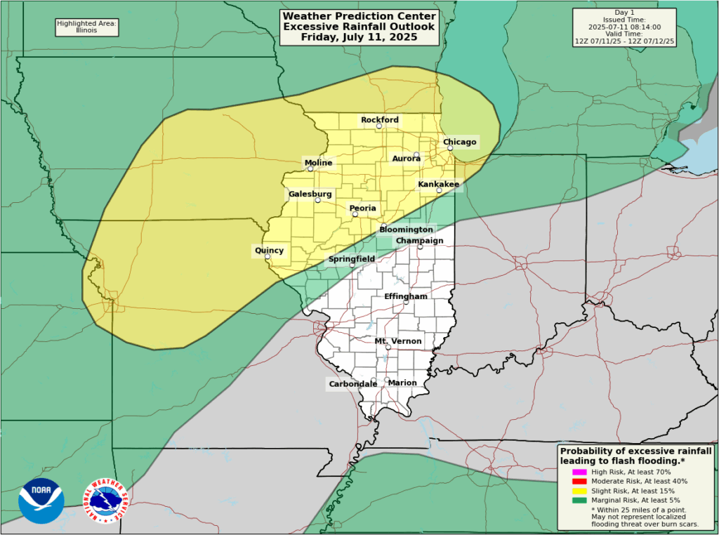
Areas of the upper Midwest, including parts of Iowa, Missouri, Wisconsin, and Illinois will be subject to heavy rainfall on Friday and Friday night. In the big picture we see a large trough over the Central Plains that will be supportive of storms. Such complexes of thunderstorms, known as mesoscale convective systems, will be possible from late morning through the early evening hours. Most likely we will see a line of storms develop over Iowa and Wisconsin before moving southward into Missouri and Illinois.
From an impact standpoint I don’t believe these will be too serious. However, given the setup, some modest flooding is possible later today where the stronger storms set up. This forecast from the Weather Prediction Center provides an idea of where the greatest risk of heavy rainfall will come later today. By late evening the flood risk should be diminishing for the Midwest.
Sizzling in the west
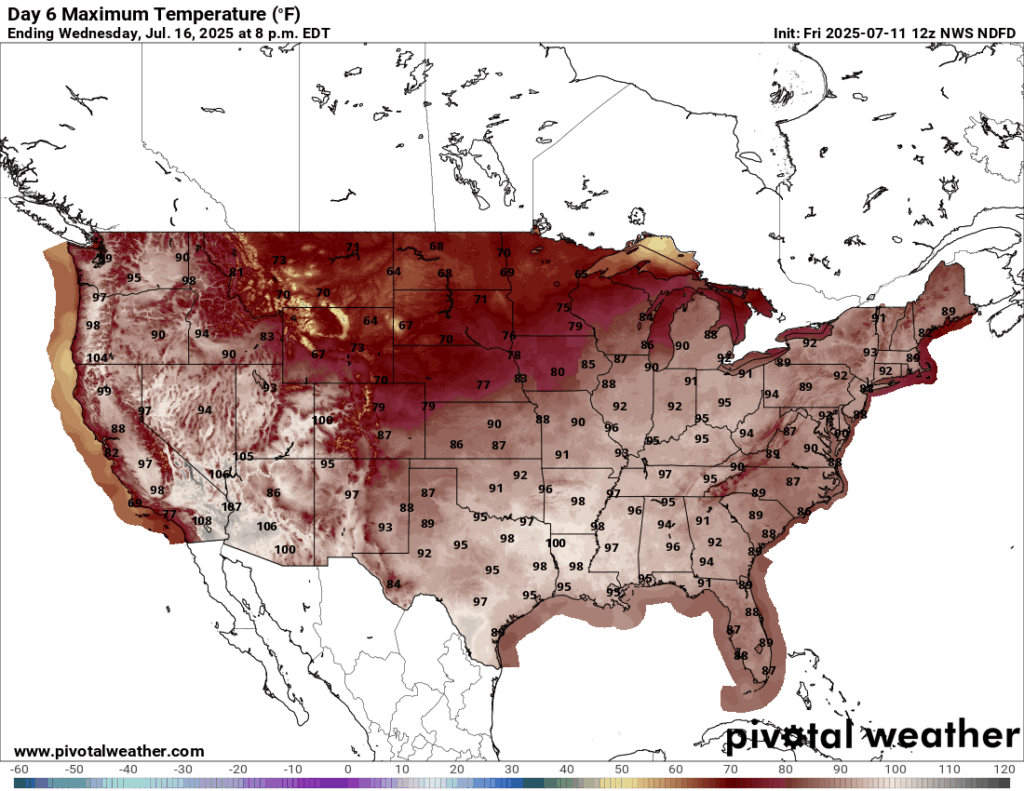
Much of the Western United States will see high temperatures this weekend above 100 degrees. For some areas in Arizona and Southern California, this is nothing new. But the highs for a broad swath of northern California, Oregon, Washington state, and elsewhere in the west will be 5 to 15 degrees above normal. This heat is due to a building dome of high pressure that will affect much of the West through Sunday. The heat should break by Monday for much of the region.
However, the forecast for the Northwest turns even more extreme next week. Areas near Portland and Seattle could see highs in the mid- to upper-90s on Tuesday and Wednesday as high pressure rebounds. There is still some uncertainty in the upper-level pattern that may moderate temperatures slightly. But for these areas this is very high heat, and an Extreme Heat Watch is in place for Tuesday afternoon through Wednesday evening.
That’s all for us today. We hope everyone has a great weekend.
The aerosol optical map is an interesting perspective. Took me a second to locate the various countries.