In brief: There is a very small chance that a weak tropical system could develop near the Florida or Georgia coasts over the next couple days. Any development would be on the lower end of the intensity scale, and the primary impact will be some heavy rainfall.
Un-Sunshine State
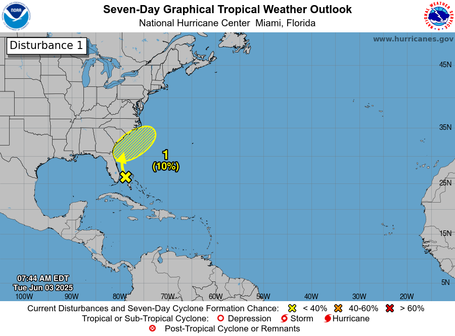
A weak disturbance is crawling up and just offshore of Florida’s east coast. The odds of this thing actually developing as it comes north are pretty low. Currently the NHC holds the odds around 10 percent. No real model solutions suggest that this will formally organize. Perhaps there’s a slightly higher chance of development as it turns the corner past the Carolinas and heads out into the open Atlantic. Whatever the case, in terms of a formal tropical entity forming, the chances are very low.
That being said, there will be impacts from this system as it comes north, and it will primarily come in the form of rainfall. South Florida took on a good dose of rainfall yesterday.
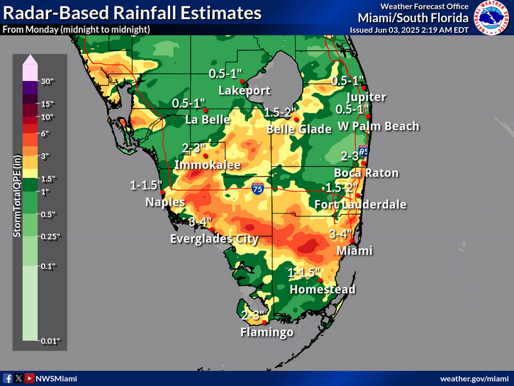
A flood watch is in effect for Fort Lauderdale, Miami, the Everglades, and Naples today. While official rainfall forecasts are on the order of another 2 to 4 inches of rain, some model guidance does hint at maximum totals in isolated areas hitting upwards of 6 inches or even a bit more. That would be most likely to occur south of Alligator Alley, which is to say in a less populous part of South Florida. Additional rains are likely tomorrow.
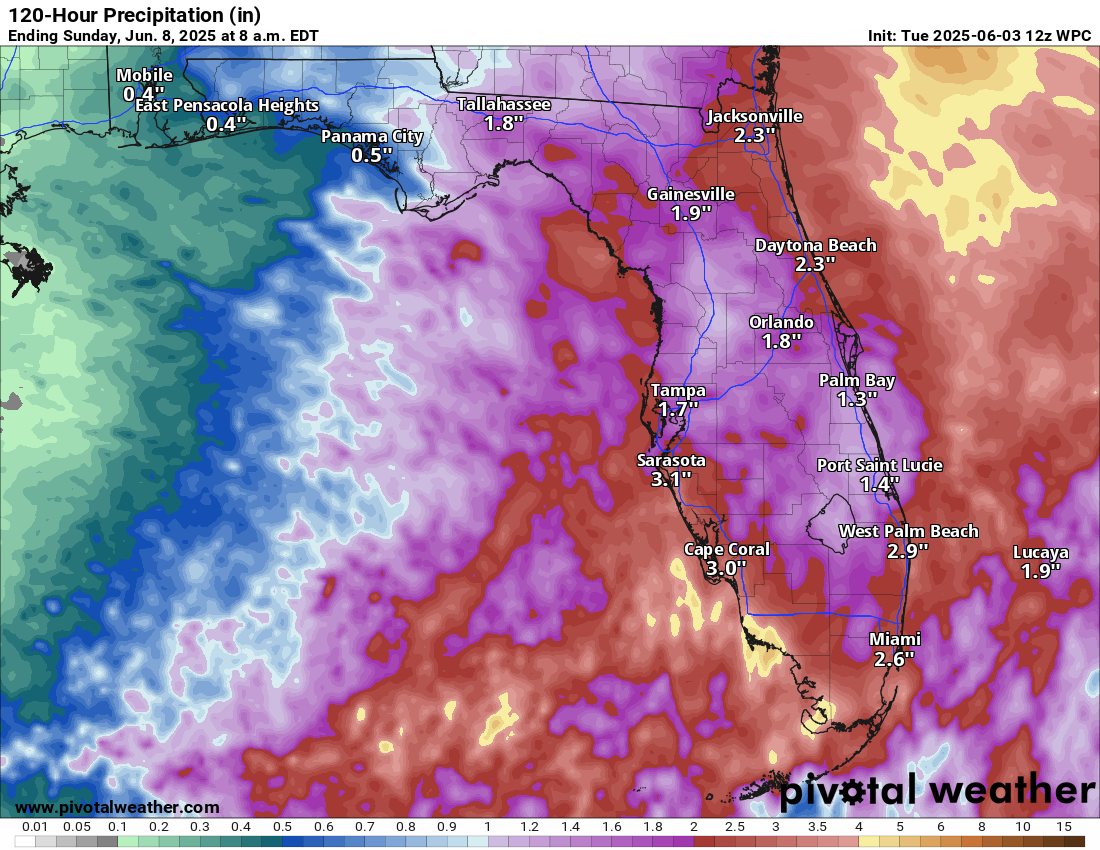
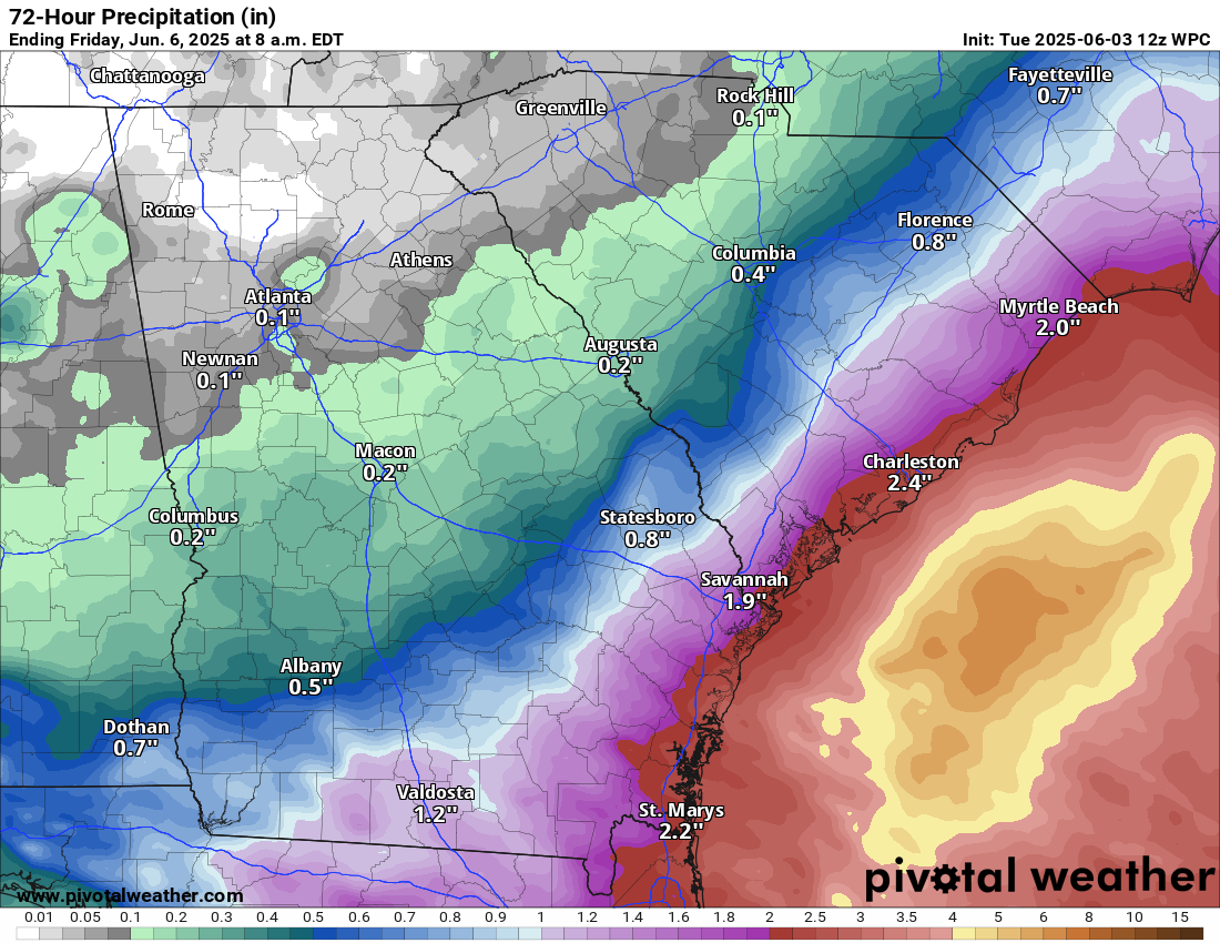
The actual disturbance we’re tracking will be up near Jacksonville by tomorrow evening. As it comes northward, it will spread some locally heavy rain up the coast. You can see from the map above how anywhere from 1 to 3 inches of rain is plausible across central and northern Florida. Some sort of weak low will probably come ashore between Savannah and Charleston tomorrow night, bringing more locally heavy rain up the coast there as well. Since this is likely to just sort of track along the coast and move inland from there, the heaviest rains will remain offshore, but anywhere from 1 to 3 inches is possible along the coast from Jacksonville through Myrtle Beach.
From there, the disturbance will turn right and exit the Carolinas out to sea where it will make another attempt at low-end development.
Bottom line? Whether this is unnamed or gets tagged as something formal, the impacts will be the same with locally heavy rain and flash flooding possible on the coast of South Carolina, Georgia, and North Florida, as well as across South Florida.
Elsewhere
Meanwhile, the GFS model has Mariah Carey’s “Fantasy” on repeat. It continues to show a fantasy (read: phantom) storm in the 10-to-15-day portion of the model. It remains alone, as it often is this time of year. No other model support exists. So we will continue to disregard it as fantasy. Broadly, conditions become a tinge more favorable next week in the Caribbean or southern Gulf, but we don’t see any specific systems of note at this time.
Could the dust impact it?
Please, can we stop this “Chicken Little” stuff. I ageee that strong tropical storms and hurricanes are serious stuff, but a “slight chance” of heavy rainfall due to a “tropical disturbance?”
Maybe NOAA has plenty of funding if we eliminate the study of these minor things.
Such spending is a problem throughout governments at all levels!
Don’t need NOAA since the orange guy still has a Sharpie
I’m sorry to be curt here, but this doesn’t make sense. The NHC’s job is to identify and track tropical disturbances. If there’s a chance (which there is), then they should identify the chance. No one’s studying it; they’re reporting on it. It’s not costing them money to do this. And flash flooding can be pretty damaging! Should we just pretend tropical storms in the deep Atlantic don’t happen because no one is impacted? No. Your argument completely misrepresents what NOAA does. And it’s important with their funding under threat to be clear about why they exist. This is a reason they exist. It may seem inconsequential to you, but if you ask any coastal emergency manager, they’re going to be grateful for these updates.
I also will be curt. I live just north of Houston, so am very well aware of the threats and do take them seriously. My whole house generator was a blessing during Beryl last year. We installed it after the Feb 2021 freeze, even though we “only ” had 8 hours of power outage since we are in the Entergy grid. In 2021, ERCOT was a joke. We have a 36 trillion national debt, and it isn’t because taxes are too low. Spending is the issue. Every federal agency including NOAA and NHC needs to find ways to cut expenses prudently.
The Euro is now showing storm development in the E Pac, while the GFS is consistently showing something rather unpleasant in the Gulf. That consistency is starting to get worrisome.
It now looks like two models showing tropical development, albeit in different locales.
At what point do we start to un-fantasize it?
*like the MC reference 🎶
Yesterday, I did note that I felt the Pacific had better odds next week than the Atlantic. Given that these GFS fantasies are annual traditions (Literally…this happens every single season in May and June) it’s still nowhere near something we need to worry over.
Thank you
Sometimes you crack me up 😆 “fantasy”. Thanks for this!!
“Fantasy” and “a tinge.” Love your writing!! You brighten my morning!
Sooo….am I good for my trip to Cancun next week?!
Nothing I’d be worrying over right now.
I’m unclear on the NOAA Natl Hurricane Center graphics—even after clicking on images & reading associated content, there’s ambiguity. So does the ‘7-day’ image show projected development (after 7 days)?…or what’s there NOW with a chance of developing further?
Prior to 2025, I’d thought there an image of the ‘current’ status…..& then the viewer could click on ‘2-day’ or ‘7-day’ to see projected development & elaboration.
Thanks so much for your hard work & expertise : ).