In brief: After a serious, prolonged warm stretch over Christmas, we’re back to somewhat more typical winter weather across the country. Powerful winds and heavy lake snows are impacting the Great Lakes, but more warm air is on the way in Texas. Southern California is in line for more rain over New Year’s as well, as Western U.S. snowpack levels sit in terrible shape this winter.
Whipping Great Lakes snow & wind
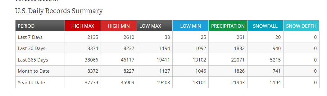
Winds have been the story across the country, along with some severe weather, and a significant winter storm in the Northern Tier. A potent cold front has finally reduced, if not outright ended the daily barrage of record high temperatures. Over the last 7 days, we’ve seen over 4,700 warm records compared to 55 cold records set across the country, according to NOAA.
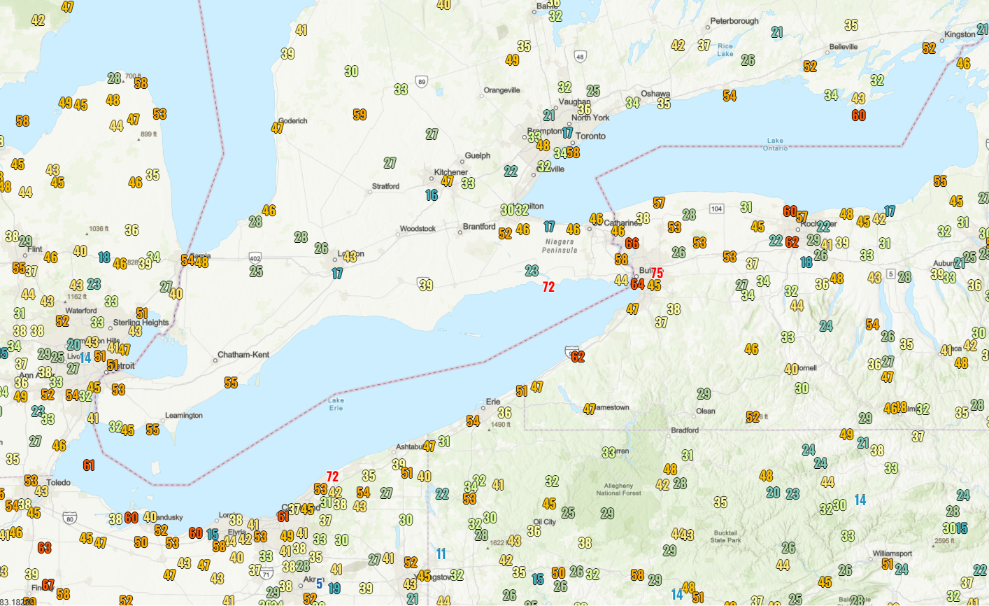
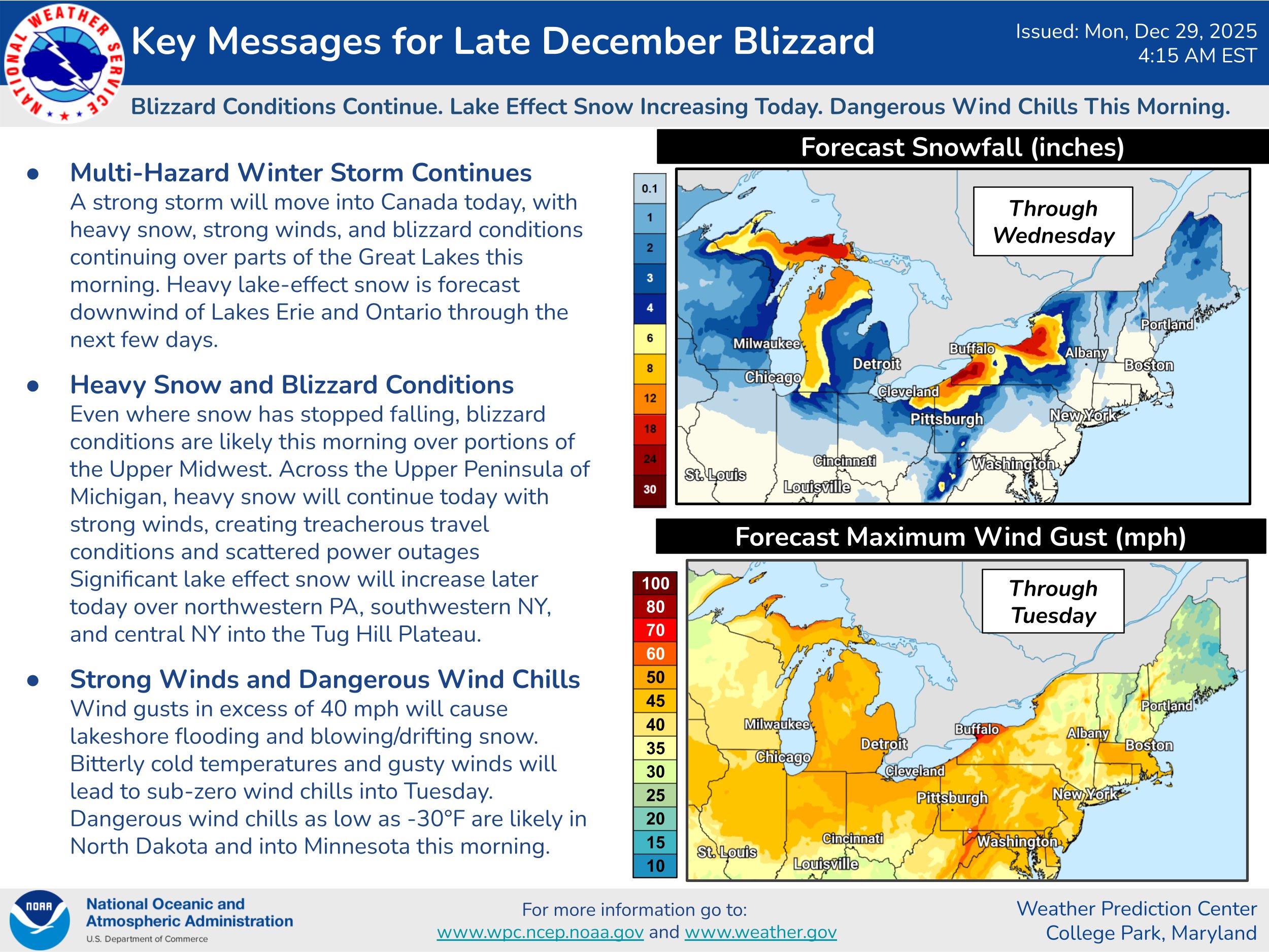
But that’s outta here. For now. Nothing about this incoming air mass is record-breaking, but it’s come in with a good bit of noise. We’ve seen power outages, wind damage, and heavy snow in the Great Lakes. Wind gusts have peaked since midnight as high as 75 mph in Buffalo and 50 to 70 mph in many other places between Lake Ontario and the Mississippi Valley.
Heavy snow will continue downwind of the Lakes, with 25 to 35 inches of additional lake effect forecast in the Southtowns down through Dunkirk off Lake Erie and between Sodus and the Tug Hill off Ontario. Blizzard conditions will persist in spots.
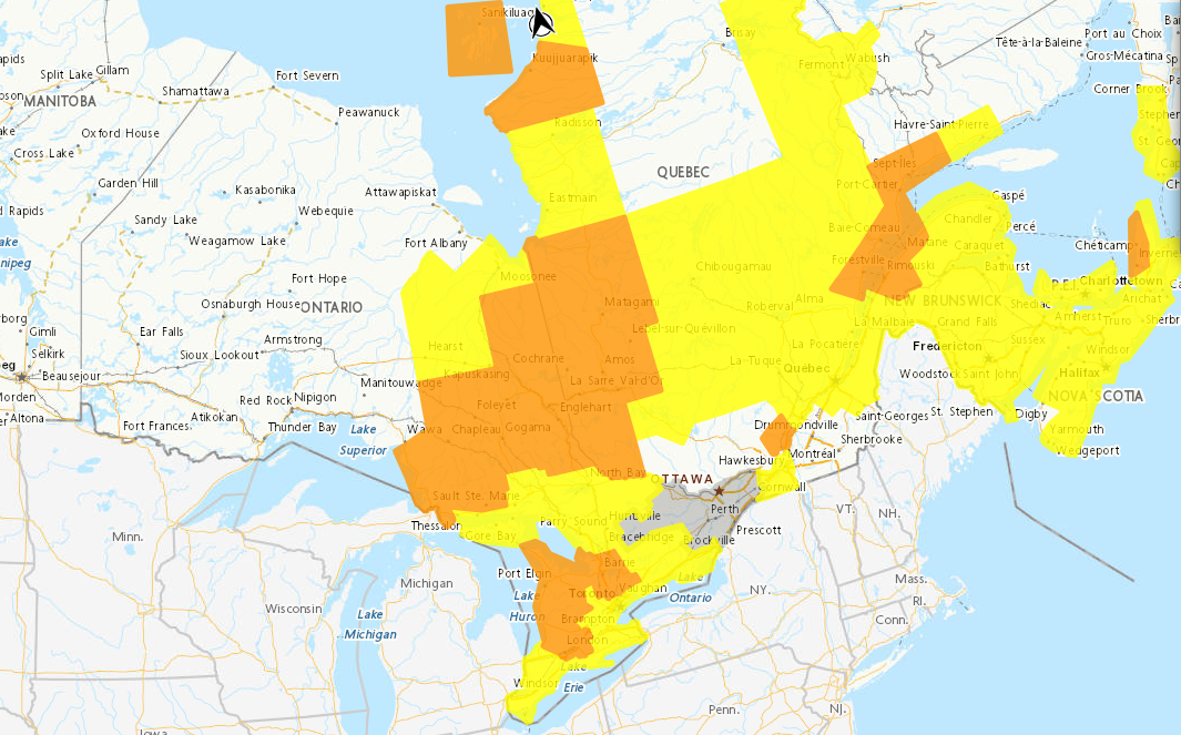
Across the border in Canada, we have numerous yellow and orange warnings for snow, general winter storm conditions, blizzard conditions, and even freezing rain in the Maritime Provinces.
Overall, a potent storm for the Great Lakes and Canada.
What’s next? More rain in SoCal, more heat in Texas
After this stretch of colder weather, it does look like we’re heading for another big warm up in parts of the Southern Plains by Friday. Record highs and near-record highs are already forecast in parts of Texas.
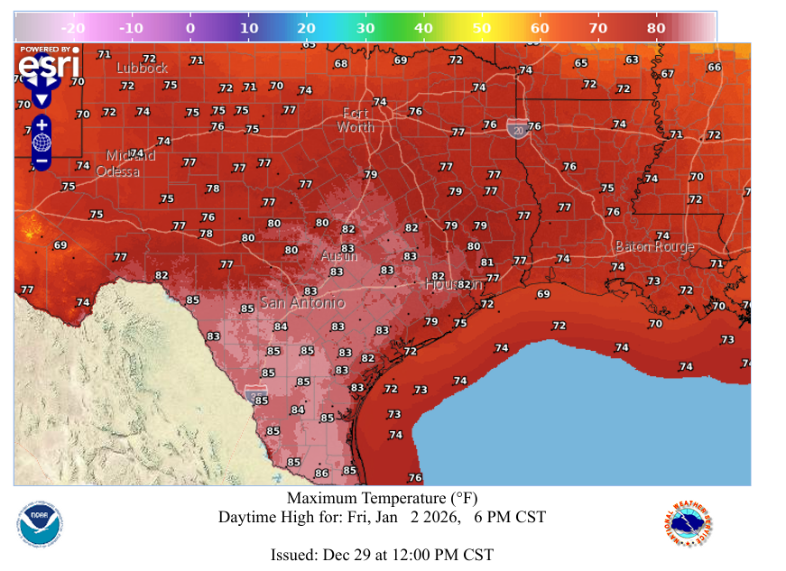
Additional record or near-record warmth may follow again next week.
Meanwhile, on the West Coast, it looks like more rain is headed for California, mainly Southern California. Showers kick off on Wednesday, peaking probably early Thursday morning, with lingering showers into Friday and a final cold front Saturday morning. The NWS has a “slight risk,” (level 2 out of 4) for parts of Southern California, including the LA Basin and mountains for later New Year’s Eve into New Year’s morning.
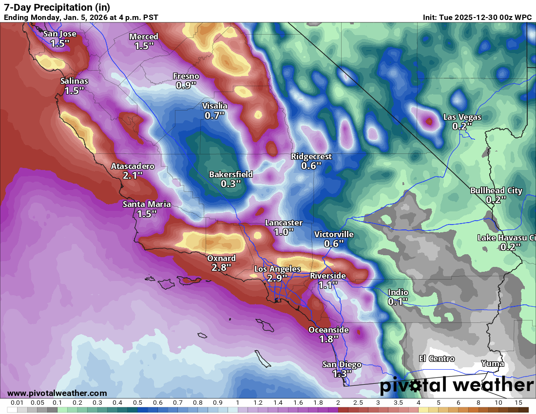
While this does not look like a major event, certainly it could be locally impactful, particularly with the heavier rain on New Year’s Eve night. For the Rose Bowl on Thursday, it looks damp but hopefully not ridiculously sloppy. Isolated heavier rain and some additional Sierra snow is possible on Saturday or Sunday in Northern California. More snow is needed. Too much of what has fallen lately in the West has been rain.
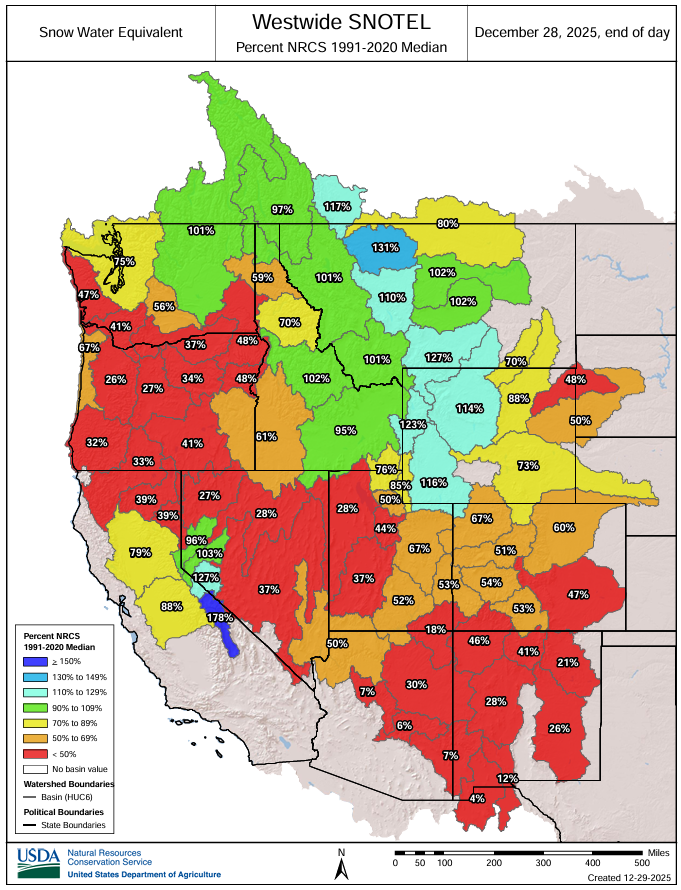
The only locations doing particularly well this winter are in Wyoming and Montana, and in most cases, those snowpack levels are normal to slightly above normal at best. Oregon, Utah, Arizona, Colorado, New Mexico; they’re all struggling mightily.
Hopefully some additional storminess can combine with colder temperatures, but admittedly, it’s not looking great right now.
Newsy Bits
Colorado River basin: We’re in overtime on negotiations on new managing rules to basically save the Colorado River and the states that rely on it. The federal government has started to put pressure on the states to reach a deal, with the Bureau of Reclamation set to release proposals to replace the river’s current operating rules. The current situation mapped out above plays very much into this, as a bad snow season could lead to radical changes to preserve Lake Powell and Glen Canyon Dam’s hydropower. The money quote? From John Entsminger, Nevada’s chief negotiator: “If you distill down what my six partners just said, I believe there’s three common things: Here’s all the great things my state has done. Here’s how hard/impossible it is to do any more. And here are all the reasons why other people should have to do more.” (States Newsroom)
Lake Powell: On the flip side of the coin… As drought and water demand slowly drain Lake Powell, Glen Canyon’s slow re-emergence is bringing back beavers and a robust ecosystem. Having finished “Desert Solitaire” earlier this autumn, this connected with me, given that most Americans don’t know how beautiful and thriving Glen Canyon was prior to the dam. (Inside Climate News)
Texas: $24 million from the State of Texas will go to Texas Tech University to expand and improve operational flood forecasting across the state, as well as the West Texas Mesonet. Two new sites have already come online in Kerr County, with more sites and even some radar data to be added. Overall, this is likely to make a big difference in how Hill Country and other parts of Texas monitor and react to flooding. (Texas Tech University)
Outer Banks: The endless battle of preserving beachfront to protect homes is getting harder and harder. In the Outer Banks, numerous homes were claimed by the Atlantic this year thanks to multiple passing hurricanes, high tides, rough seas, and a rising ocean. (Inside Climate News)