Headlines
- Alberto made landfall in Mexico this morning, with heavy rains continuing for some areas.
- The system behind Alberto will likely track similarly but the northern extent of impacts will be much less this time around.
- Invest 92L off Florida has about 24 hours to get together before coming ashore in Florida or Georgia.
Alberto makes landfall in Mexico
Tropical Storm Alberto came ashore this morning in Mexico near Tampico as it continues to deliver pockets of heavy rain, gusty winds, and tidal flooding.
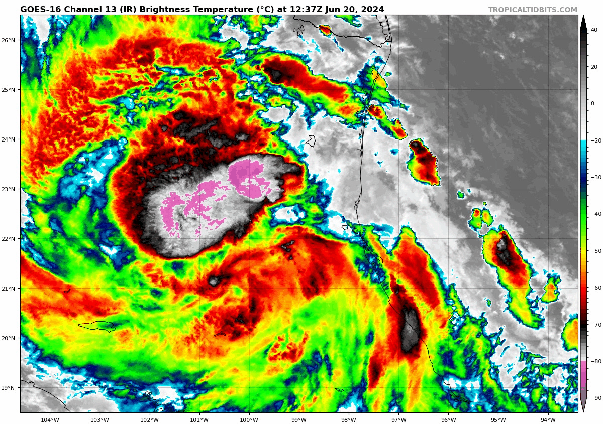
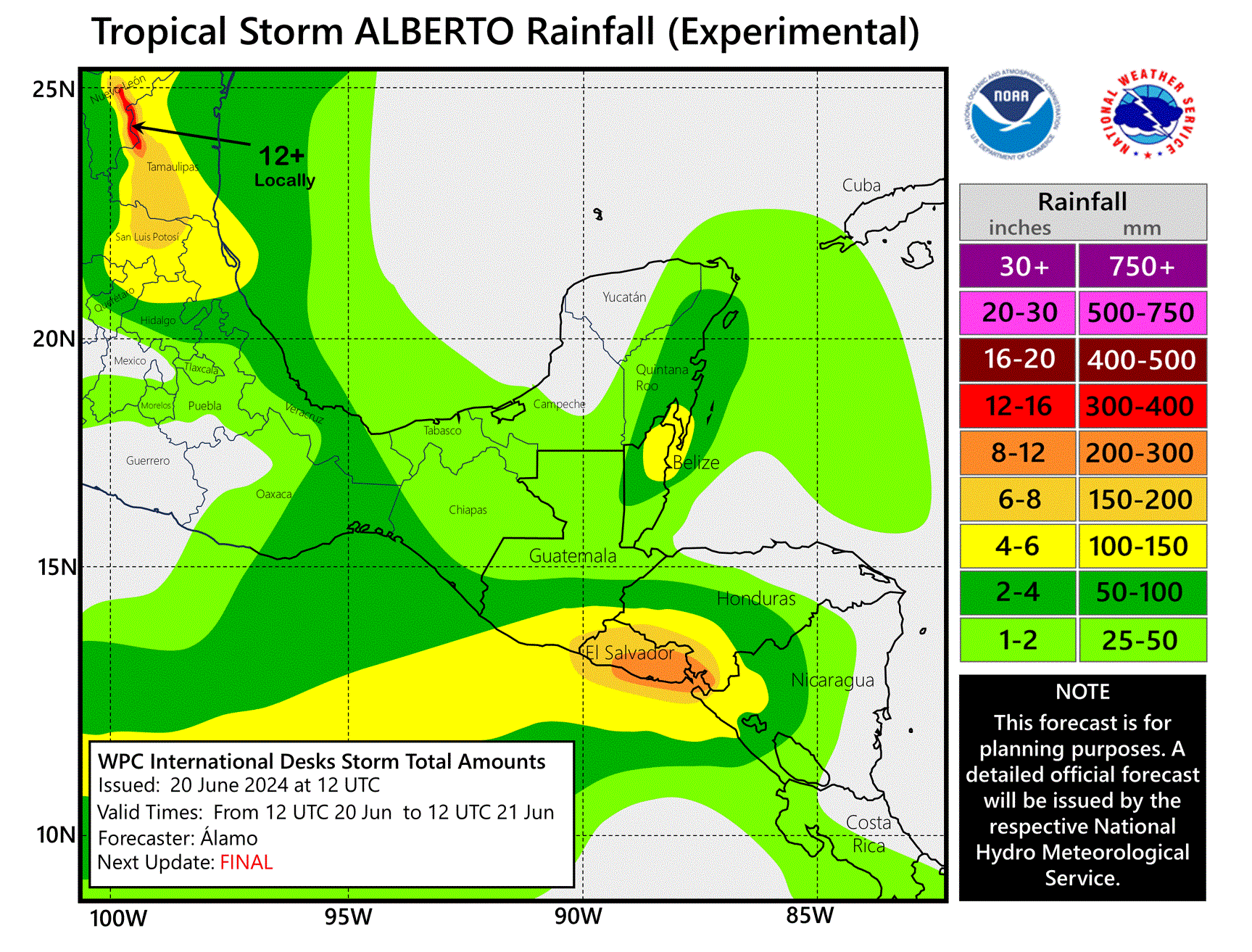
The heaviest rain by far is in northeast Mexico, which has the potential to see up to another foot of rainfall. Serious flooding will be possible in spots, even if a lot of this rain is generally beneficial. It’s almost never all good news with these things.
Tides and winds will continue to slowly subside today on the Texas coast. Waves will probably stay up into tomorrow as broad east or east-southeast flow across the length of the Gulf helps to aid in that.
Rain totals have generally been manageable in Texas, with some flash flooding in spots. Almost seven and a half inches of rain fell between Corpus Christi and Refugio just near Copano Bay.
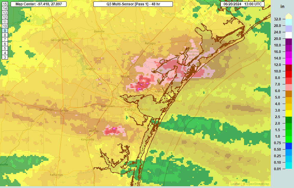
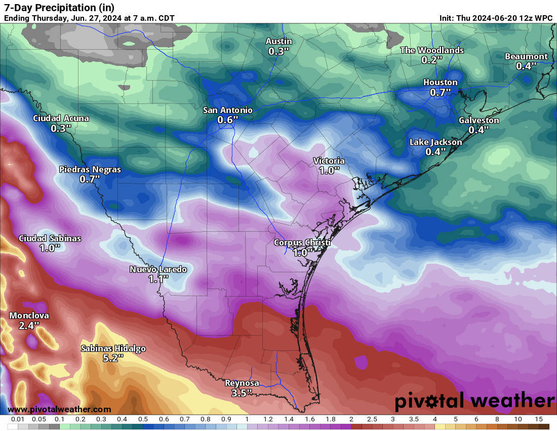
Most parts of South Texas received about 1 to 4 inches of rain from Alberto. In reality, it would have been nice to see more rain in this region, as reservoirs remain in bad shape due to long-term drought. Some additional rain will be possible over the next 24 hours or so before a break and then only a glancing blow from the next system. Perhaps we can eek out another inch or two in spots, which would help reservoirs a bit further.
Speaking of…
Alberto’s tagalong
We continue to watch the chances of an Alberto II type system move into the Bay of Campeche this weekend. The National Hurricane Center has given it an odds boost today, up to a 50 percent chance of development now. If sports betting were a thing in weather, you’d probably be placing money on a same month parlay in the Bay of Campeche. This system will probably emerge out of Central America tomorrow or Saturday and quickly track on Alberto’s heels into Mexico.
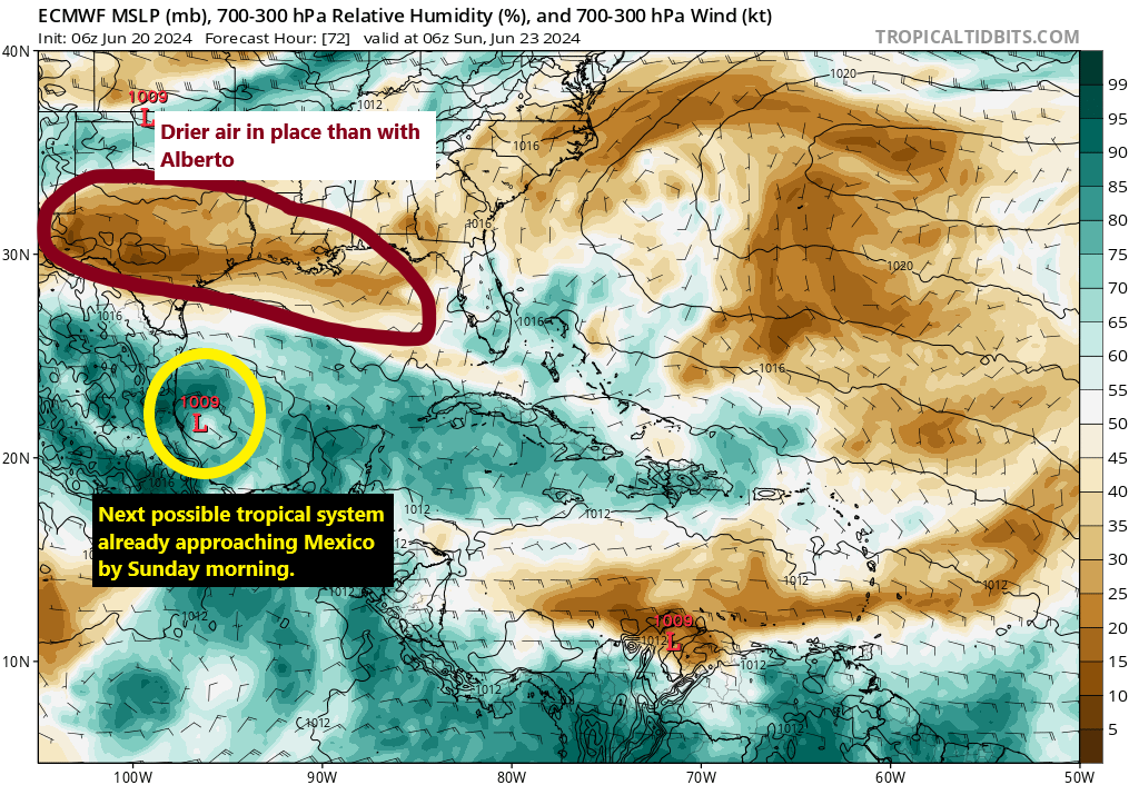
This system, while sitting with a 50 percent chance of development may have some more hurdles to overcome than Alberto did. The key one may be drier air than was in place this week with Alberto. By early Sunday morning, model guidance has this system moving toward or into Mexico, but it has a large area of dry air to the north, something that was not in place this week. High pressure in the upper atmosphere will sink south this weekend from the Mid-Atlantic into the Plains and Mid-South, which will put the squeeze on this disturbance and limit intensity and how far north it can come. For Texas, this system may be a non-issue, aside from some (welcome) rain as noted earlier. For Mexico, this will have the potential to again produce heavy rain and flooding concerns in the mountains. We’ll continue to watch.
Invest 92L off Florida
Our last stop today takes us off Florida, where Invest 92L has formed from the disturbance tracking westward toward the Bahamas. Odds of development are up to 40 percent with this one, and it will quickly come ashore in Florida or Georgia tomorrow. Could it become a tropical depression? It’s certainly possible. Whether or not it does, we’ll see.
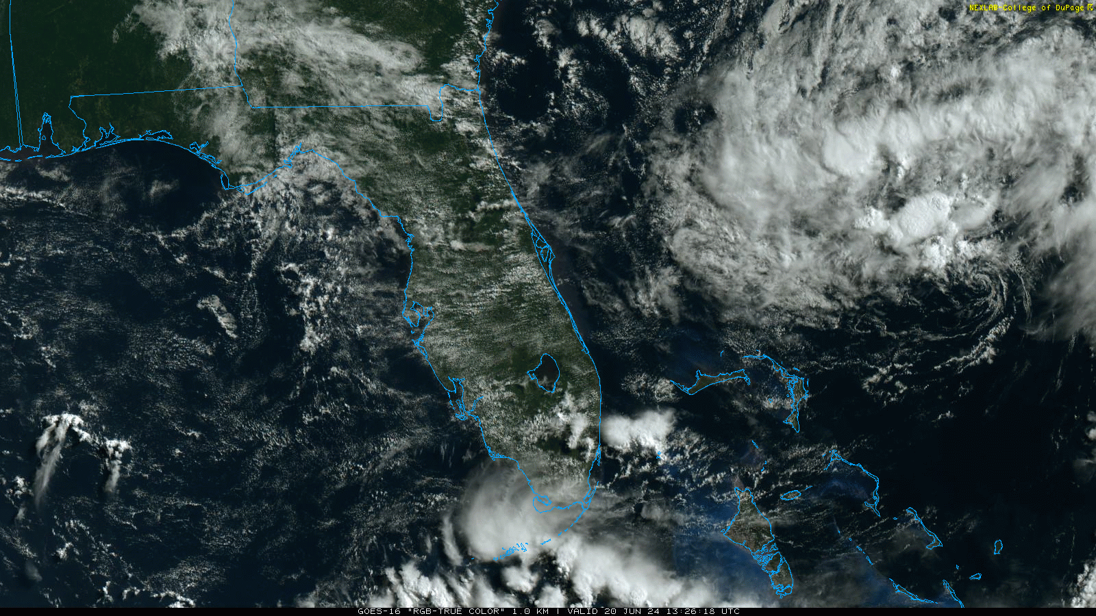
Invest 92L is in a bit of a tough environment. While the exposed center is a neat looking feature on satellite, it indicates generally hostile surroundings for development. Still, it’s got a chance to put something together before landfall tomorrow. A little bit of extra rain or a breeze will be possible north of about Cape Canaveral from this one, into coastal Georgia. But land impacts should not go much farther than that. Anyone vacationing in Florida or Georgia should be mindful of very high rip current risks the next couple days though.
That’s all for today. I’m taking a few days off, but Eric will be around to jump in as needed through the weekend!
While Alberto didn’t have widespread flooding impacts in our area, the thunderstorms it spawned wreaked havoc on air travel into and out of both Hobby and Bush Airports on June 19. FAA issued a “ground stop” for both at about 4:45. Prior to that, a large number of planes were placed in holding patterns as normal landing frequency wasn’t possible due to the unstable conditions. Personally, my flight form John Wayne Orange County (CA) left on time at noon PDT with IAH (Bush) arrival scheduled for 5:20 PM, and everything was fine until we hit west Texas. At that point, the pilot advised that “many planes were stacked in holding patterns.” Air Traffic Control advised over an hour wait even before initial approach to IAH. We didn’t have enough fuel to wait that long, so we diverted to Dallas to refuel. We landed at DFW just past 4 and found 20+ other planes also needing fuel. By the time we “topped our tanks,” the ground stop was in place.
Ultimately, our crew “timed out” under FAA rules, and we had to find replacements. We got lucky that an incoming flight that landed around 10:20 PM at DFW had a crew that could take our plane.
We finally pulled to our gate at IAH at around 12:30 AM. So, what should have been a 3-hour 20-minute flight turned into a 12-hour “flight from Hades.” For those of us terminating in Houston, this was a major inconvenience but paled in comparison to those folks who had connections at IAH.
Moral of this story: DO NOT, get on ANY plane to Houston when there are severe thunderstorms in the area.
You just underscored why we are hesitant to answer questions from people about their flights.