Headlines
- An additional 6 to 12 inches of rainfall is likely to exacerbate developing flooding problems in portions of South Florida.
- Potential tropical development in the Atlantic from the Florida system is possible but unlikely.
- Moisture shifts west across the Gulf next week and will impact Texas and Mexico with locally heavy rain.
- Drought relief likely in eastern Mexico.
- A potential for a short-lived tropical system in the Bay of Campeche could locally enhance rain totals in Mexico next week as well.
Florida flooding starting to take shape
A 48 hour rainfall map in Florida really tells the story.
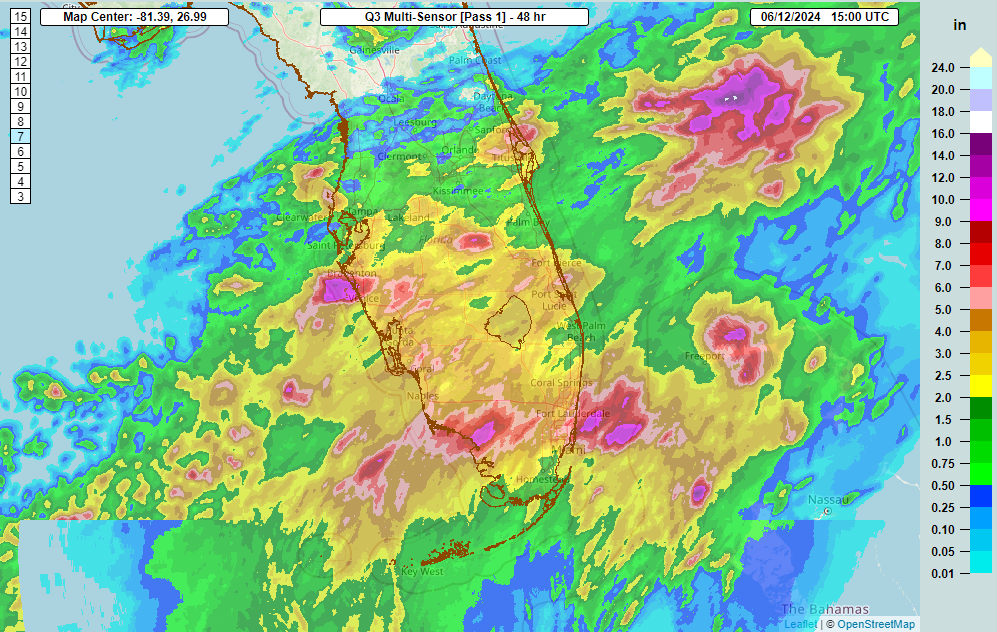
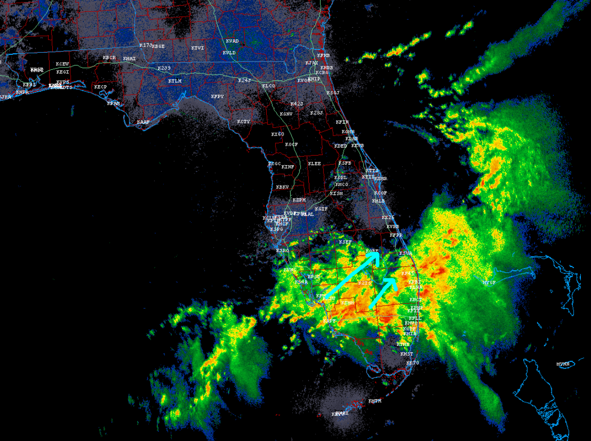
Sarasota in particular has seen some pretty rough flooding. The highest total through earlier this morning was 11.38″ just southeast of Sarasota. Radar shows heavy rain continuing to push east or east-northeast across Florida in a pretty stable fashion. That means a continued dumpage of rain for the region.
How much more rain is coming? A lot. Flooding problems are likely to get worse across Florida in the coming days, and flood watches are hoisted from Bradenton south and east to Miami and into the Keys.
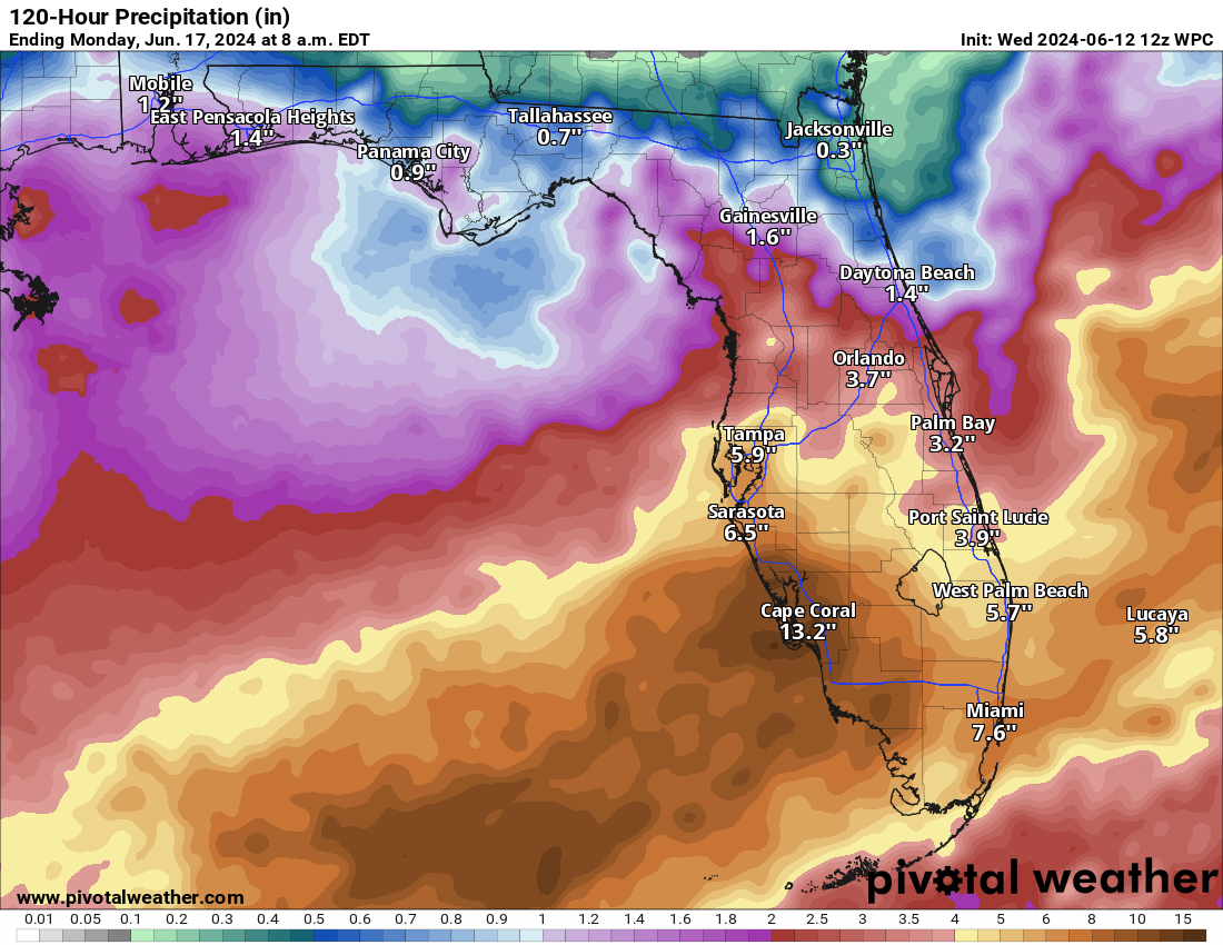
With another 6 to 12 inches of rain on the rain, it’s safe to say flooding is likely at times and in spots, especially those areas that see localized higher amounts. This is a true firehose of moisture the next few days, eradicating drought and causing new problems.
Atlantic development possible but probably unlikely
We are still watching for potential that we can spit out the A-storm or a depression from the morass over Florida. Low pressure will push off the coast today and into the Atlantic over the next few days. It’s been dubbed Invest 90L. As a reminder, “invests” are convenient ways for meteorologists to run some extra modeling on disturbances that may become tropical systems. The list cycles from 90 to 99L in the Atlantic and then starts over again. Invest 90L is our first of the season.
As it scoots northeast, we’re still hanging around a 20 percent chance from the National Hurricane Center that we see a tropical system develop from this.
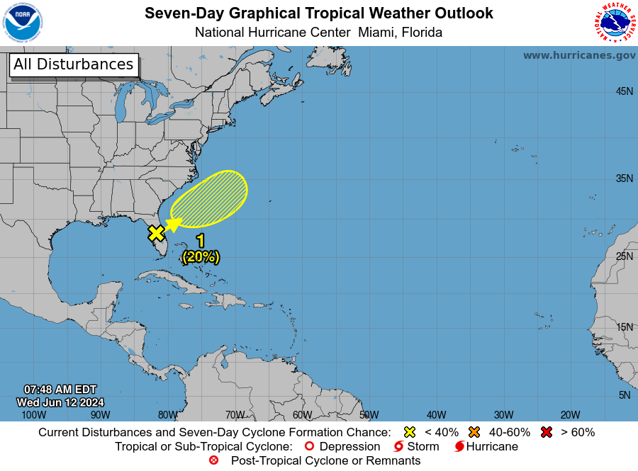
Personally, I don’t see it happening, but for those who are interested in mostly meaningless tropical activity, we can watch it over the coming days.
What’s going to happen in the western Gulf?
The next phase in our party in the Gulf will be this moisture plume shifting directions. We can track this by using the GFS model’s precipitable water forecast (PWAT). PWAT is basically a measure of how much moisture is available in the atmosphere. Once you get up over 2 inches or so, you’re talking about a very, very juiced atmosphere capable of big time rainfall. Over the next 8 days (based on the most recent GFS model that came out this morning), we can see how the plume shifts to focus on the central Gulf Coast, then Texas, then Mexico by later next week.
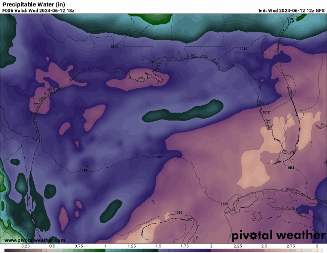
The good news for Louisiana and Texas is that this appears to keep moving, eventually setting up in Mexico as we see potential tropical development in the Bay of Campeche next week. As of right now, the NHC has given that area about a 20 percent chance of developing once it establishes there next Sunday or Monday or so. Based on most available operational model and ensemble model guidance, we would expect any development to be rather sloppy and quickly come inland over Mexico, probably near Tampico, give or take. Obviously, we’re a week out so things will change, but that’s the best guess right now.
Meanwhile, as all that moisture comes west, a couple important things will happen. First, we could see locally heavy rainfall along the Gulf Coast. These types of scenarios often lead to the first tier of coastal counties getting drenched while the next tier of counties inland has slightly less intense rainfall.
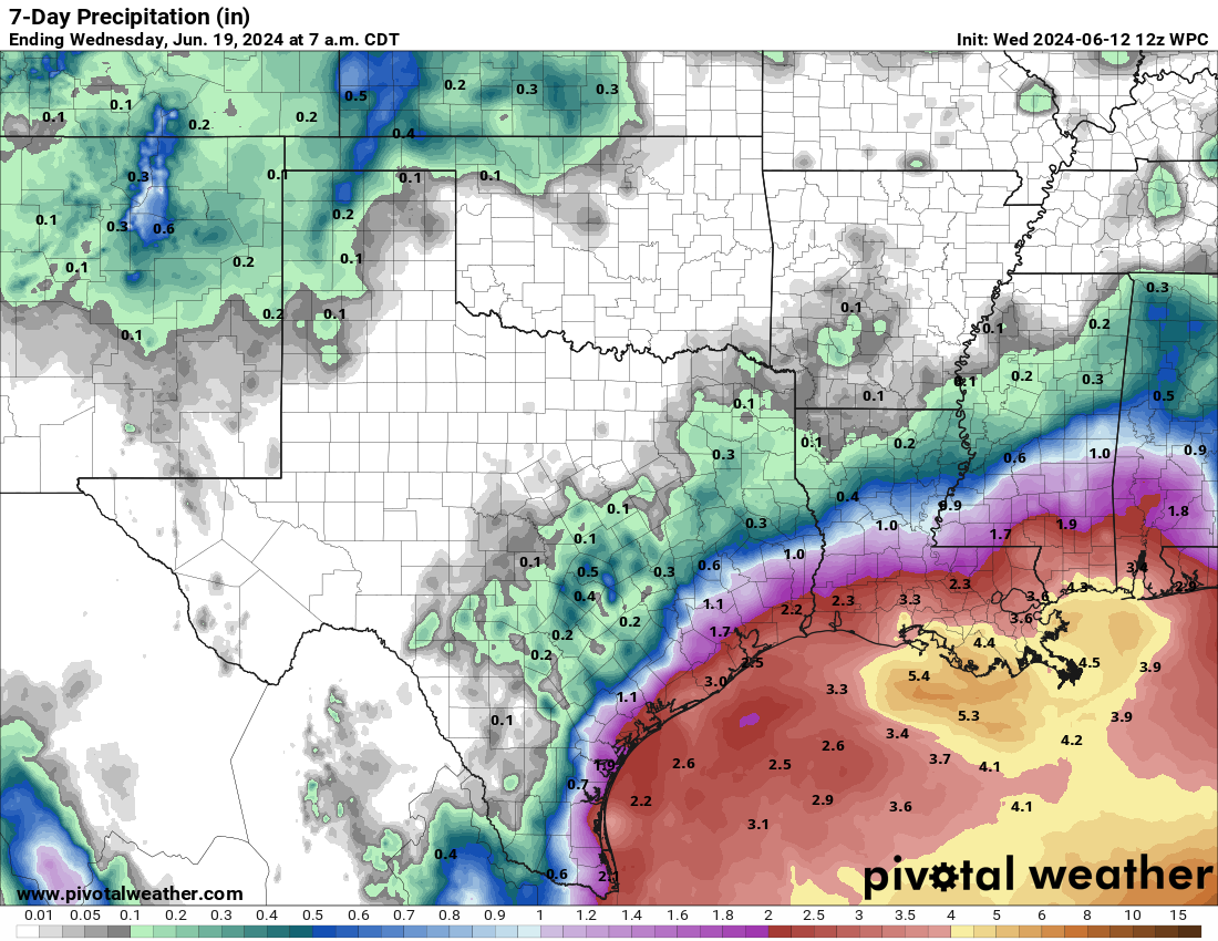
As of now, we’ll say 2 to 5 inches on the coastline between Mobile, AL and northern Mexico, with higher amounts possible in localized areas on the Texas coast. Interestingly, Mexico could see significant rainfall from this. They had a serious drought heading into last month. And last month was exceptionally hot and dry. So they need rain.
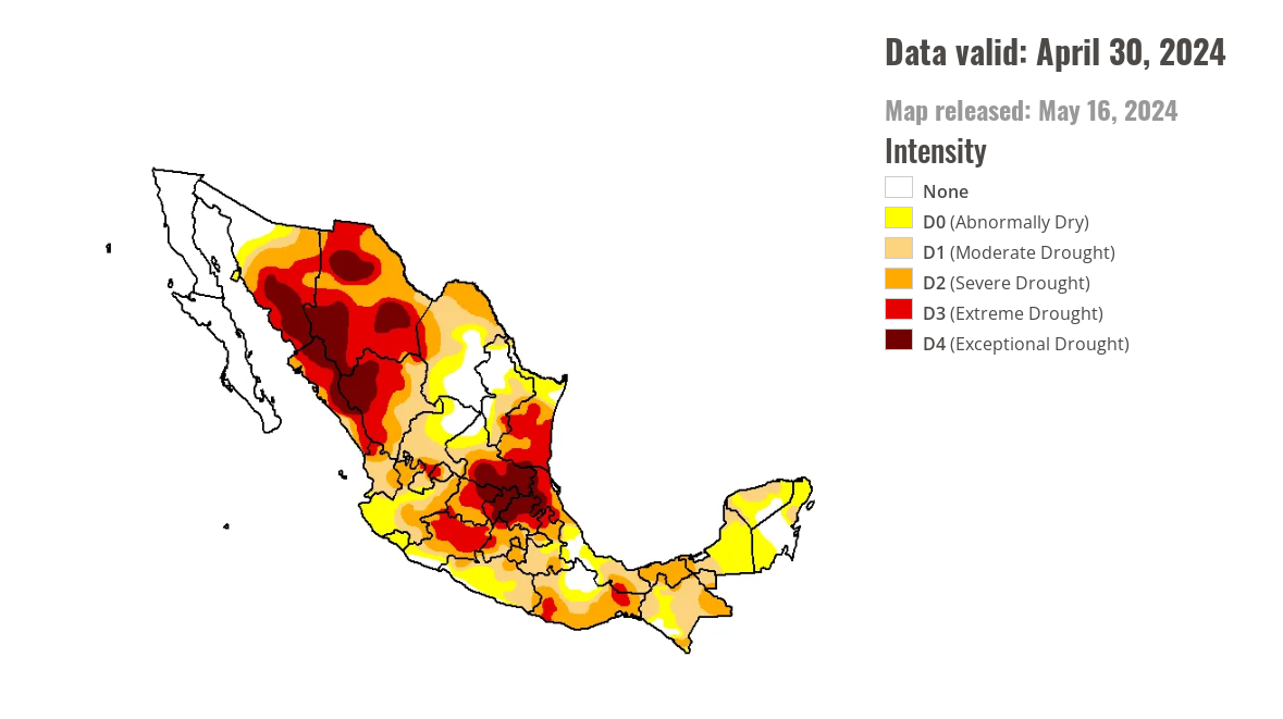
The hope is that it won’t be too much rain too fast. But at least this should help eastern Mexico begin to slip out of drought. It will also allow for cooler weather across Mexico, something that area could use as well.
Matt, I’ve finally gotten the courage to pull my head out of the sand. I have been reading your explanations throughout and suffered along with Houston during recent flooding. Thank you for your valuable insights and explanations. What do sailors say … something about Godspeed, Fair Winds and Following Seas. TY again, Alyce (Gulf Shores AL, beachside)
Thanks, Alyce! Here’s to a quiet season.
Is dumpage a technical term?
It is now!
So there are two “storms”? One going east through Florida and a second, the plume heading west in to the Gulf coast and Mexico?
Correct. Both are tied back to the same sort of thing, but they are two separate entities ultimately. The second one won’t form til early next week.
Yea. Two down 24 to go!
So, watching the weather in Lauderhill, Florida on Friday for the USA vs Ireland match. If it were to rain out, the USA moves to the second round. So it seems the rain will still be there Friday morning.
The cricket tournament moves into the West Indies in the next round. Hopefully tropical development doesn’t ruin it.
Hey Matt, do you think we’ll see anything like what’s happening in Florida?
In Texas? Not to that level. But, honestly, you never know in these sort of setups. If it did occur, I would expect it at the immediate coast though, not inland.
My mistake, I should have clarified I meant Texas. I’m East of Houston over in the Baytown area.
“Obviously, we’re a week out so things will change, but that’s the best guess right now.”
I know the language is a bit colloquial, but I’d encourage you to phrase such a statement more like:
“Obviously, we’re a week out so things will change, but that’s what the data suggests right now.”
While weather forecasting still involves a lot of uncertainty, it is most definitely not guessing, something that those of us who follow you here and at Space City appreciate. Meteorology as a profession still suffers a great deal of “It must be nice to be able to be wrong all the time and get paid for it” perception.
Thanks for including the updates on Mexico. I have friends who have moved there and it’s nice to see a bit more on what they are experiencing. Gotta be able to talk about the weather, huh?!