Headlines
- Potential Tropical Cyclone 9 is likely to become a depression and/or tropical storm by tonight or tomorrow morning.
- It will accelerate north toward the coast of Florida, with a landfall likely on Thursday somewhere between Pensacola and Tampa. Hurricane impacts will spread across Florida’s west coast and Panhandle.
- PTC 9 or Helene is expected to be a significant storm and potentially a major hurricane (cat 3+).
- Because of fast forward motion, PTC 9 or Helene will spread damaging wind far inland from the coast, across South Georgia, possibly into the Atlanta area (depending on track) and into the Carolinas.
- PTC 9/Helene will be a significant, disruptive storm for the Southeast Thursday, Friday, and possibly beyond.
Give our site a bookmark and check back in later today and/or tonight for some additional updates to this post.
Potential Tropical Cyclone 9
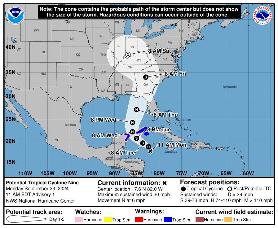
We have our potential tropical cyclone now, and it will be known as PTC 9. Expect this to formally become a depression later today and a tropical storm tonight or tomorrow morning. This should take on the name Helene.
The first forecast track from the NHC is very much in line with strong model consensus right now, which takes Helene somewhere between about Pensacola and Tampa, with the majority of guidance favoring the Panama City to Cedar Key corridor, close to the Big Bend of Florida. One thing to be very, very clear about: There is still a fair bit of spread among individual ensemble and tropical model members. You can use the slider here to compare the 6z runs of the European and GFS ensemble member forecasts for Thursday around midnight.


The latest tropical models are very clustered on the west side of Apalachee Bay, with a track very near Tallahassee once inland. So you can see that the model guidance is in great agreement right now on the broad picture of things. I would still watch this very closely in Tampa and Sarasota, as well as Pensacola, as those locations are in the “margin of error” as you might say.
There is also a fair bit of cross-track spread in timing, with some models showing landfall as early as Thursday afternoon and others more into Thursday night. Assume you have until Thursday morning to finalize your preparations on the coast. Anything beyond that is just proverbial icing on the cake.
PTC 9’s intensity outlook
One thing we are unfortunately continuing to be confident in is that this storm has a high ceiling in terms of intensity. There remains a significant spread within tropical model guidance with intensity, as some models suggest tropical storm intensity, while others are at the top end of major hurricane intensity, perhaps a higher end cat 3 or cat 4.
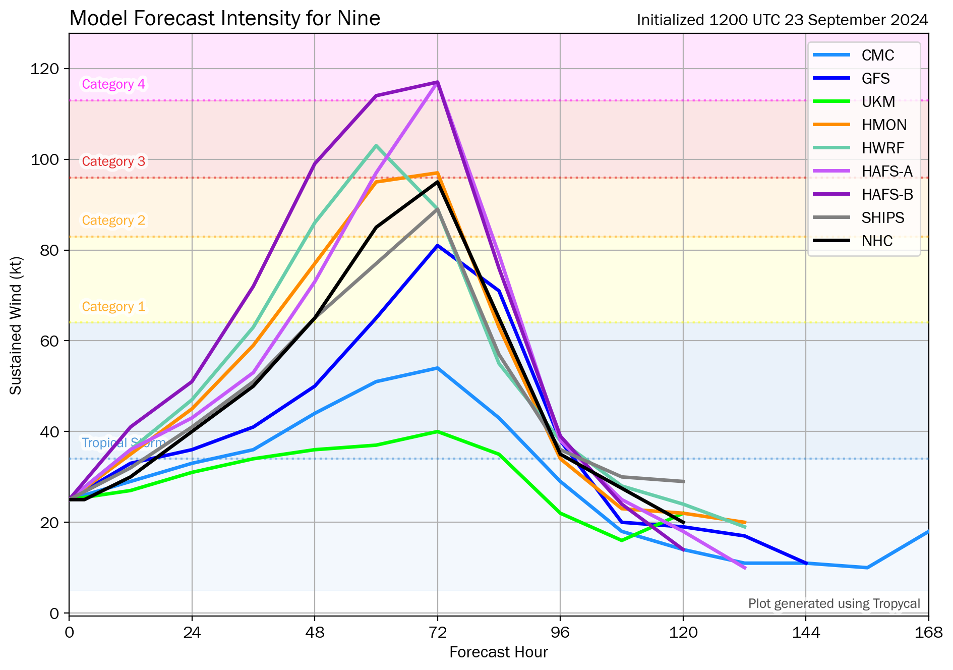
The NHC projecting a peak intensity of around 110 mph, just on the cusp of major hurricane strength is a good place to be right now, but do realize that the risk for a stronger storm is very much on the table. As we’ve been noting, this track is about the worst possible one a storm could take from a “fuel” standpoint in the Gulf of Mexico. PTC 9 is likely to travel over significant ocean heat content the majority of its life cycle, and water temperatures never really cool off much on approach to landfall. Given the anticipated forward speed of PTC 9, we are likely to see this storm come ashore at or near peak intensity.

Folks in Florida should be preparing for a major hurricane impact in the Big Bend or Apalachee Bay with all the threats you’d expect: Surge, wind, waves, flooding, etc. This has the potential to be as bad or worse than Idalia and much worse than Debby in the Big Bend.
Inland risks
The threats from PTC 9 are going to extend much farther inland than usual. The storm will be hauling as it moves inland. Even if it comes ashore weaker than forecast right now, it is likely to carry tropical storm and hurricane force winds well inland from the coast. Those impacts should begin Thursday night and continue much of Friday. This includes much of South Georgia, as well as possibly South Carolina, north Georgia, and portions of North Carolina or Tennessee. The map below shows wind gusts as forecast by the GFS model earlier today. Keep in mind that the final track will determine exactly where those winds occur. A track closer to Tallahassee will shift this farther west. A track closer to Cedar Key will shift this a little to the east.
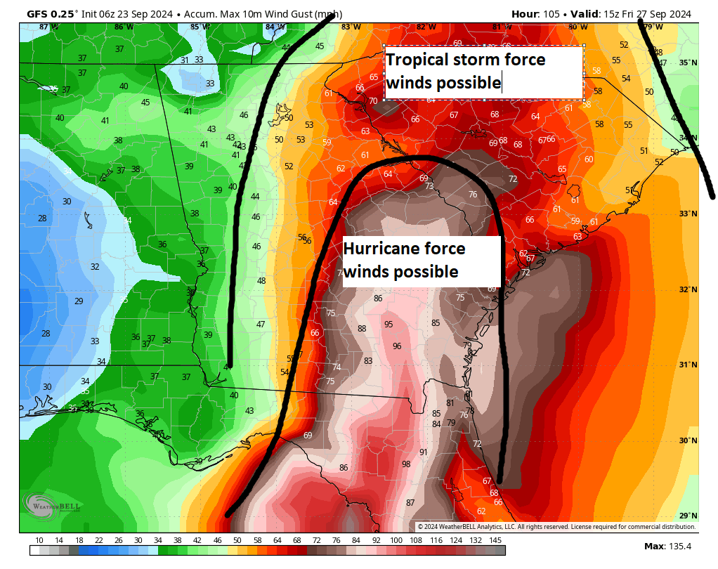
This is important because this type of scenario could mean widespread, significant power outages and wind damage across Georgia and South Carolina. Metro areas, including Tallahassee, Atlantic, Macon, Savannah, Columbia, Charleston, Greenville-Spartanburg, and Charlotte should be prepared for this scenario and prepare with at least a few days of food and water should this come to fruition.
In addition, heavy rainfall will occur with PTC 9, and flash flooding will be possible, especially in mountainous areas well inland from landfall.
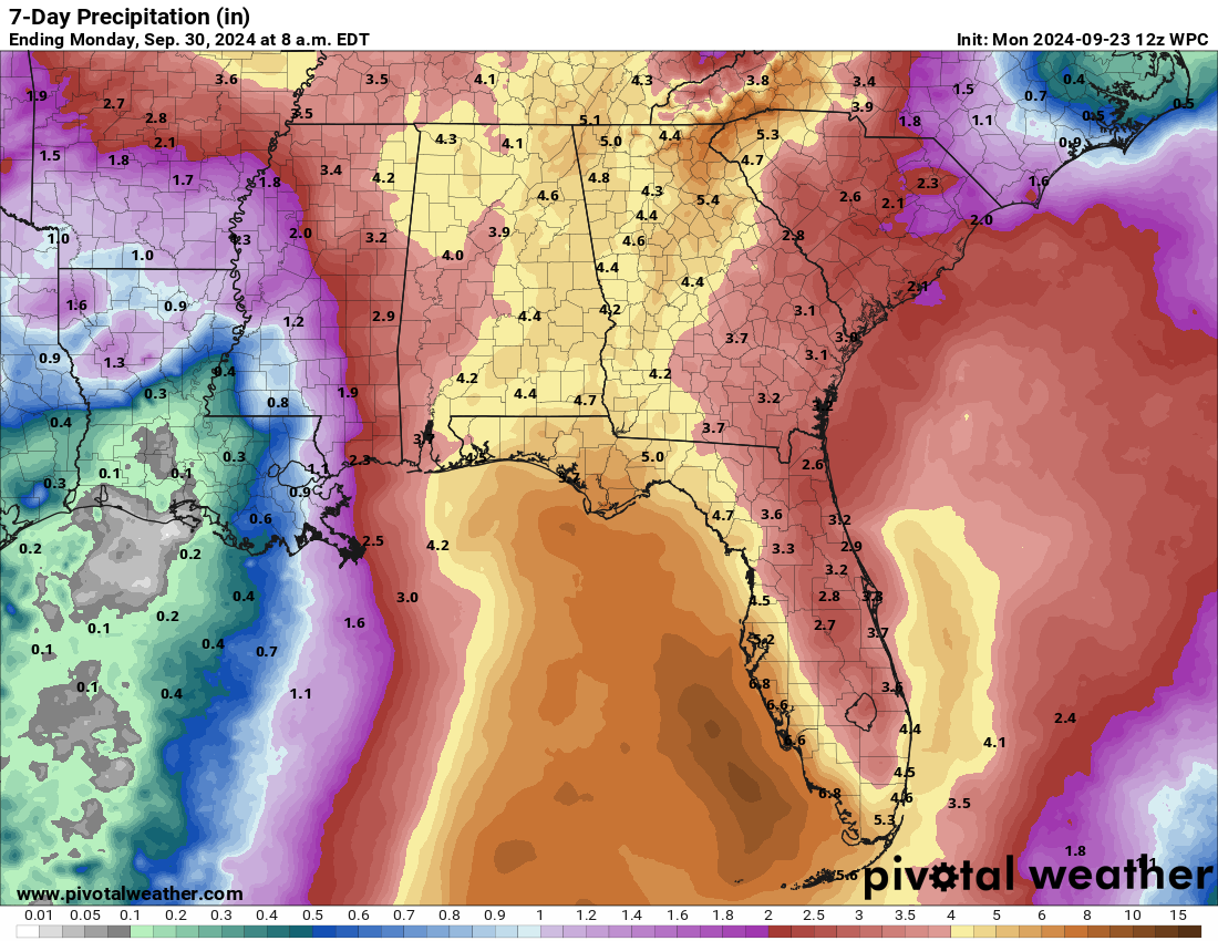
This is going to be a significant, disruptive storm for portions of Florida and the Southeast U.S., in addition to perhaps western Cuba and the Cayman Islands where 10 to 12 inches of rain may fall. Impacts will be widespread and damage could be significant. Folks should begin preparing immediately and follow forecast changes closely in the days ahead.
That certainty sounds intense.
I have a trip to Atlanta planned for this weekend. Is it safe to continue with those plans? How do you think this will affect air travel.
Can’t tell you anything about air travel since they do their own thing. But Atlanta should be much improved after Friday.
How do you think this will impact Orlando? Thanks for the coverage, by the way!
Breezy with periods of rain/storms likely. Could be some isolated tornadoes I suppose. But hopefully not terribly menacing there. Keep tabs on any forecast changes.
Thank you for looking out for us non-Houstonians. I’m prepared if Alabama coast gets alarming and thanks to you I have a good understanding of the possibilities. Even have nearby hotel reservations just in case! Again, thank you! Alyce
Wishing you the best 💓
Matt, thanks for all you and Eric do. Is Michael (2018?) an analog for this storm….late season, quick intensification, similar location?
In some respects it is, but it would take a lot to go wrong to get a redux. But the chances of that happening are not zero by any means.
With respect to the analog with Opal in 1995, this system has the potential to ingest quite a bit of dry air from the deep trough forecasted to develop to the NW of the storm over the Gulf states. During Opal, there was general SW flow aloft, but a strong trough was not present. Intensity forecasts will be very tricky with this storm, as evidence by the forecast spread. 700 hPa charts indicate dry air wrapping around the storm in the latter stages of its landfall approach, which could complicate strengthening, along with the increased upper level shear (50+ kt winds at 200). Tropical systems can interact favorably with upper level troughs if the outflow is enhanced, but this trough, if verified by the models, looks like it might put a damper on the intensification as it nears the NE Gulf.
Perhaps the NHC should consider a new warning to put up on their map: ‘Rapid Intensification is a strong possibility’ or something like that.
It looks like the system will flare up suddenly. It won’t take long to transition from a disorganized ‘thing’ to a strong storm, so people need more warning time as they might not view a red unnamed blob as much of a threat as they would a named storm.
Could give people more time & options.
I agree…
How bad do you expect the weather to be Thursday morning between Biloxi,MS and Houdton?
Not bad at all right now.
Thoughts on traveling to Destin on Friday? We are supposed to check in that afternoons
Thinking the worst should be past by then. As long as it stays on track, Destin would see minor to moderate impacts and should be open for business this weekend.