(11:40 AM CT Update): PTC 9 has been upgraded to Tropical Storm Helene. No big changes have been made to the forecast. According to the National Hurricane Center, there is still a bit of uncertainty on the exact center location, and this means that despite the great model agreement, there is still a bit of uncertainty in the track forecast. Aside from that, everything else appears on track.
The Lower Keys were added to the Tropical Storm Warning with this advisory. Previous post follows.
Headlines
- PTC 9 continues to fight off a little shear which is slowing its initial organization.
- As that relaxes, rapid intensification and organization should ensue, with PTC 9 expected to become Major Hurricane Helene by Thursday.
- Landfall is a little later on Thursday now, likely somewhere between Panama City and Tampa with a focus on Apalachicola through Cedar Key. There is still some uncertainty on this.
- Storm surge from the Big Bend and Nature Coast through Tampa Bay is expected to be as bad or worse than what occurred during Hurricane Idalia in 2023.
- Impacts from wind and rain will extend far beyond the landfall point with Georgia and the Carolinas likely to see strong winds and flash flooding.
PTC 9 this morning
PTC 9 continues to lack the ingredients necessary to be a depression just yet, but we continue to edge closer to that point.

What’s holding it back so far? There’s a bit of wind shear mixed in with all this from an upper low over the Yucatan. Tropical systems don’t like wind shear, and as long as that continues, the pace of development will be sluggish. That is not expected to be the case, however, as modeling weakens the shear in the next day or so, allowing PTC 9 to have a less hostile environment over some of the warmest water in the Atlantic basin. That should lead to strengthening and potentially rapid strengthening at that.
PTC 9’s forecast: Angles matter
The overall forecast for PTC 9 has not changed a whole lot since yesterday.
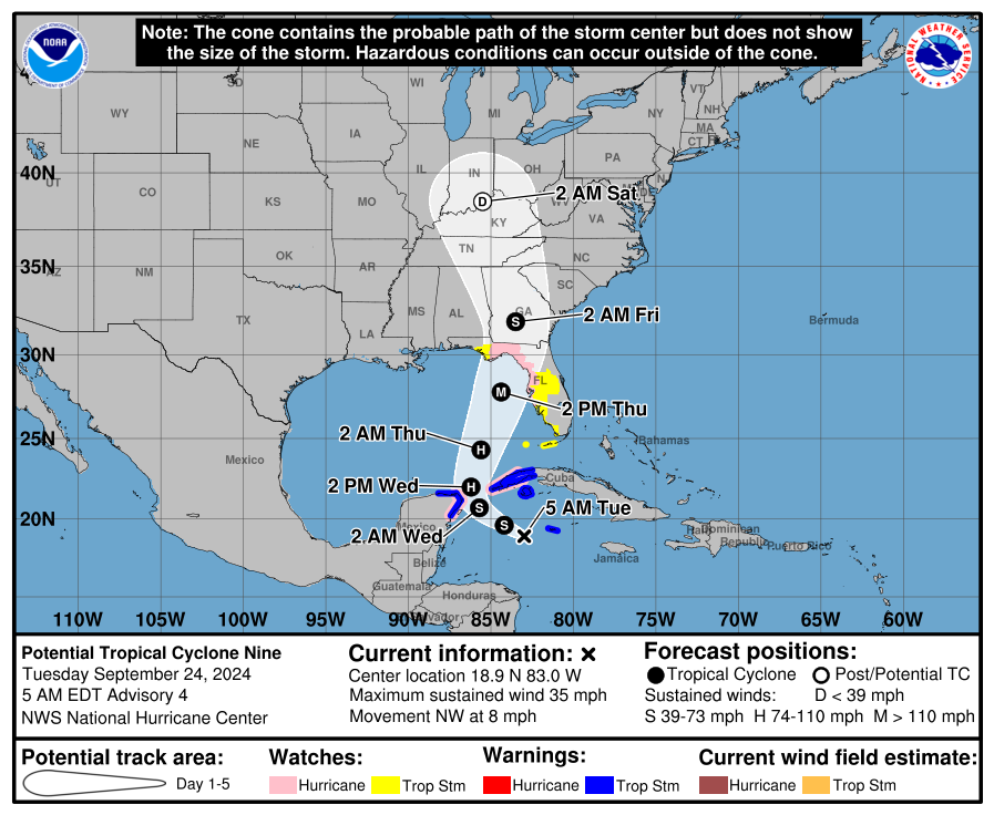
The cone has narrowed a hair to between Panama City and Tampa. Hurricane Watches are now in effect for the Florida coast, as well as inland in the Panhandle. Tropical Storm Watches including Orlando are now posted as well. Expect some of these watches to expand later today.
On the surface, this looks like a pretty easy forecast: Tropical models are in generally good agreement on a track to the northwest, then north, then north-northeast. The clustering is pretty solid in the modeling in Apalachee Bay or near the Big Bend of Florida. So, simple right? For my college football fans: Not so fast, my friends.
The fundamental problem in predicting storms that turn is the angle at which it all happens. Generally, models handle the concept of this well, and indeed we have very good agreement right now in the models.
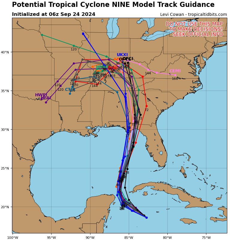
Because of Florida’s unique geography with a peninsula jutting out to the south, the exact landfall point gets harder and harder to pin down when a storm comes in from the south or southwest. A shift of 10 to 15 miles out over the Gulf can lead to a shift of 20 to 40 miles with respect to landfall location in Florida. We often talk about not focusing on the exact track, and indeed there’s a reason for that as impacts extend far from the center. But for things like storm surge, that exact landfall point is crucial in determining how things will turn out. It also makes the difference for places even well inland to be on the “dirty” eastern side of the storm or the slightly less menacing western side.
As long as the tropical models are correct, we’re likely to see this chug north-northeast into Apalachee Bay or the Big Bend. However, if the models are not quite grasping the interaction with an upper low over Arkansas properly, well, that could change things a bit. There’s a path to get a storm much closer to Tampa, as we discussed last night and as the ICON model continues to show this morning with a track coming ashore near Cedar Key rather than Apalachee Bay. For now, the most likely window for landfall appears to be Apalachicola to Cedar Key, with lesser bands around that to Panama City on the west and Tampa on the south/east.
The takeaway here is that this is a storm where focusing on the entire cone makes a lot of sense.
In terms of intensity, not much has changed since yesterday. We still struggle with intensity forecasts. One needs to only look at Hurricane John yesterday, which came ashore after 9 PM as a 120 mph category 3 storm in Mexico while initially forecast to be a 70 mph tropical storm at 3 AM. (Credit to the NHC however for constantly stating in their discussions that there were higher risks, and even substantially higher risks than the explicit forecast showed).
But we still expect that PTC will become Hurricane Helene and a major hurricane at that. The National Hurricane Center has this as a category 3 storm at landfall. And model support is generally for a strong storm.
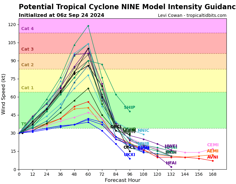
The takeaway: A powerful hurricane is likely to strike Florida’s coast late Thursday, likely somewhere between Apalachicola and Cedar Key but with risks extending just beyond those goal posts.
Impacts from Helene/PTC 9
We have our first look at storm surge today from the NHC advisory, and it’s not great news.
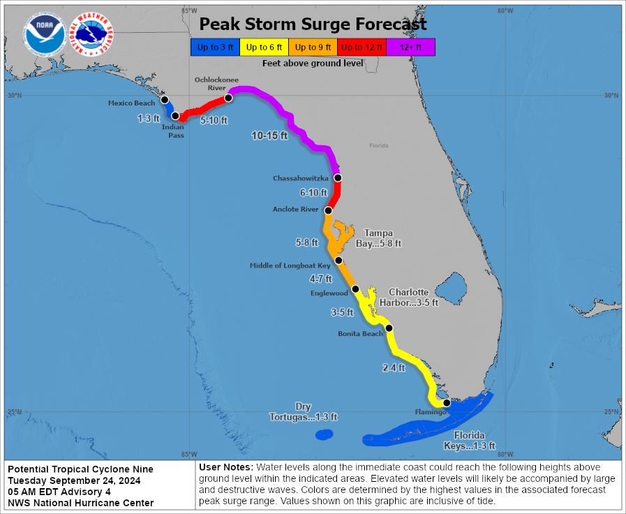
Values of 10 to 15 feet in the Big Bend would be in line with or worse than what occurred in Idalia last summer. A 5 to 8 foot surge in Tampa Bay would also be in line with or worse than Idalia. So for planning purposes, those areas should consider Idalia as a benchmark for minimum impacts, with risk for something worse. The wind field and size of this storm is expected to be somewhat broader than in Idalia, which also is concerning from a potentially worse impact standpoint.
PTC 9’s forward speed is likely to aid in carrying tropical storm and hurricane force winds well inland. The map below shows roughly where, given the current track, tropical storm and hurricane force winds could extend. And that’s a huge area. Things get complicated on Florida’s east coast, including Jacksonville, as well as up toward Savannah where stronger winds are possible than in other inland areas near there.
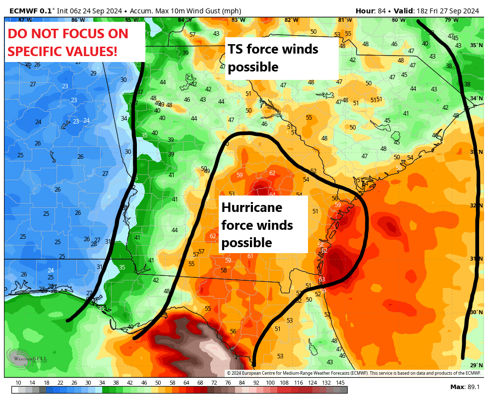
The extension of hurricane force winds inland will depend on the intensity of the storm at landfall and its exact forward speed from there. But suffice to say this has the potential to be a destructive inland wind event too, extending from North Florida into much of Georgia and South Carolina and even parts of North Carolina.
In addition to the wind will be heavy rainfall, and that’s expected to cover a massive area of the Southeast.
We’ve seen worse rain events, but spatially, this is going to put a lot of places at risk of flash flooding.
Obviously, isolated tornadoes are a possibility along and to the right/east of where this storm goes.
The takeaway: Significant impacts from PTC 9/Helene are expected to extend well inland from the coast.
We will update this post today as we can if anything changes. We’ll aim to have another post out early this evening with the latest.
John had Hurricane force winds extended outward only 10 miles from the center and Tropical Storm 45 thus a very very tiny storm.
So direct hit on the empty elbow of FL, North Central FL of half million ( only city is Gainesville). That’s assuming it doesn’t badly hit Tampa metro. So sorta lucky. PAM
Thank you for this helpful explanation. You mentioned the possibility of some potential for deviation of the track. Are any factors in place that would keep a more westward motion in check?
Not really. Most of the risk here is probably skewed to the right half of the spread in track. Basically, I’d feel more comfortable in Panama City than Tampa.
Ugh. My mom, older sister and nephews live in the Tampa area.
After the immediate impacts, the turn West and SW in the plots is interesting. Any reason why this seems to be going the opposite direction than usual?
Yeah, we’ll have to touch on this later this week. The overall pattern is kind of sloppy inland. Basically, with an upper low over Arkansas, the two systems may interact with each other with Helene forced north and west and the upper low driven south and east. Fortunately, Helene will be a shell of itself at that point, but this will have implications on the day to day weather in the Southeast. More to come on that.
Got a college student in Savannah. Time for her to get bottled water and non-perishables?
She should be keeping up with weather updates for the next few days to determine plans of severe weather.
Wouldn’t hurt. But just stay tuned to the forecast there. More worried about power loss than anything.