Changes since this morning
- PTC 9 became Tropical Storm Helene and its satellite presentation has improved markedly since earlier today.
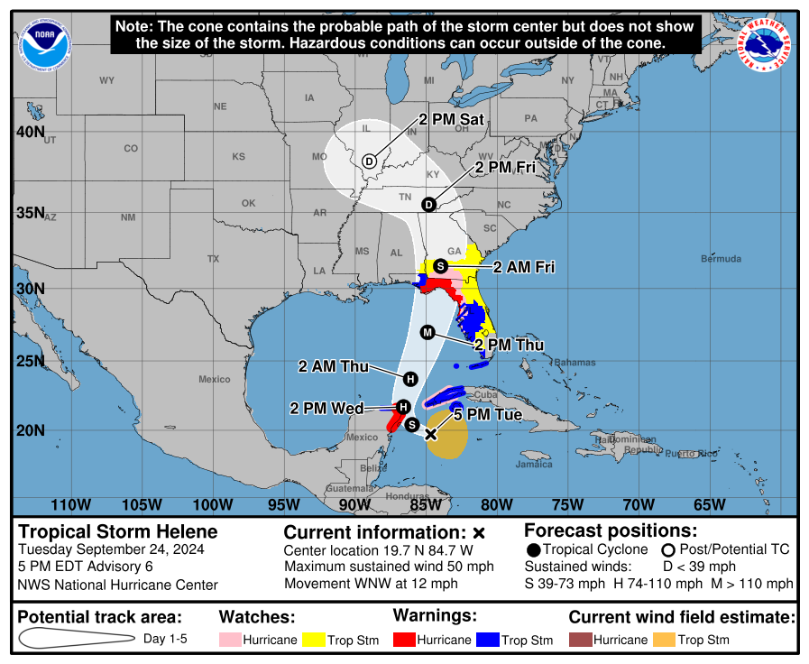
- Hurricane Warnings have been issued between Anclote River just north of Clearwater and Mexico Beach in Florida.
- Storm Surge Warnings have been issued from Flamingo to Indian Pass in Florida, including Tampa Bay and Charlotte Harbor.
- Tropical Storm Warnings have been issued for the Lower & Middle Florida Keys and the west coast of Florida between Flamingo and the Anclote River, which includes Tampa Bay.
- Tropical Storm Watches are now posted on the East Coast of Florida and Georgia between the Palm Beach and Martin County line and Savannah River.
Tropical Storm Helene is slowly getting organized now, as it appears that the wind shear impacting it earlier has leveled off, and it’s feeling the heat of the warm water underneath it. Expect a steady, if not rapid strengthening process to start unfolding soon. SHIPS model guidance indicates rapid intensification risk that is about 8 times climatology over the next 48 hours, not the biggest number we’ve seen in recent years but a very healthy signal that says Helene is going to take off eventually.
Helene’s satellite presentation has improved pretty dramatically today.
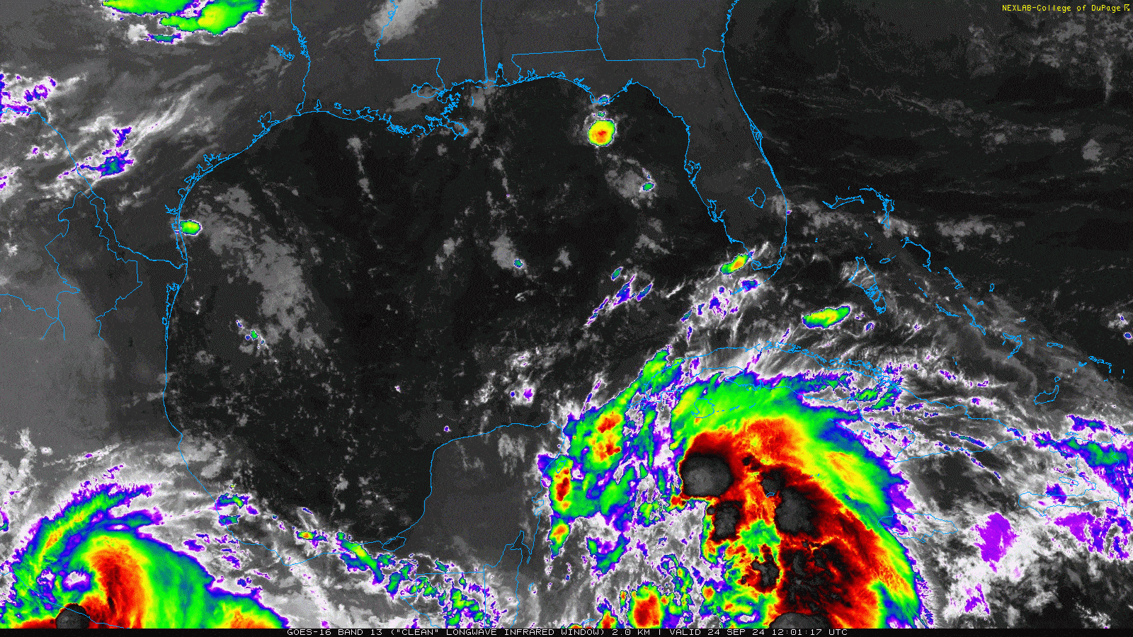
It now “looks the part” much more than it did earlier. One thing to note is the size of Helene. This is a pretty sprawling storm already, and as it comes north, it will continue to maintain that size, with tropical storm and hurricane force winds extending out farther than we’ve seen with recent Big Bend storms in Florida. According to the NHC’s latest discussion, this storm will be in the 90th percentile of major hurricane size at this latitude. In other words, it’s big, and the winds from Helene will be felt, especially on the east side far away from the center and outside the cone.
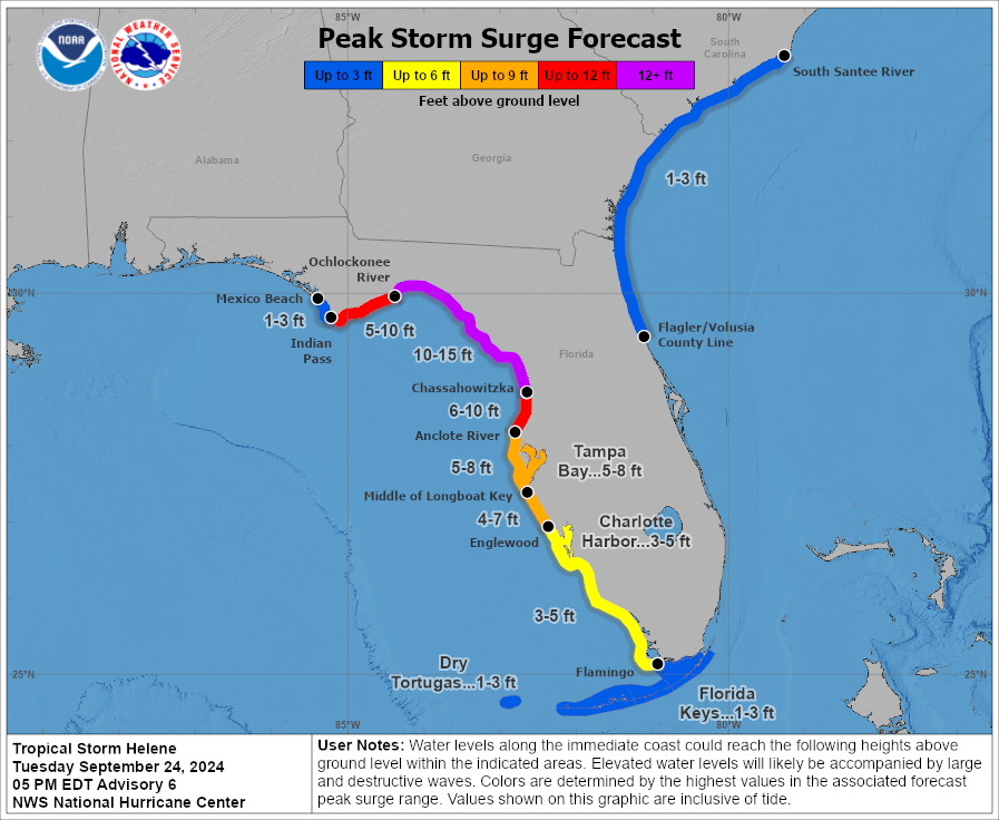
The forecast has changed little since this morning. We still anticipate a major hurricane making landfall in or near the area between the Big Bend and Apalachee Bay in Florida. The size of the storm will complicate the surge potential somewhat on the west coast of Florida, leading to surge values that should be as bad or worse than were experienced in Idalia. We covered that a bit more earlier today.
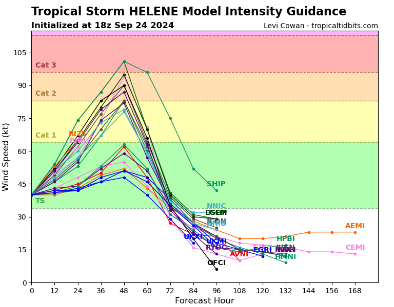
The intensity forecasts on tropical modeling for Helene have stalled somewhat today, certainly not a bad thing! However, I would be hesitant to read into that too much, as we’ve seen many examples of storms “overachieving” in this part of the Gulf. The biggest question that I have at this point is how close to peak intensity Helene will be when it comes ashore. There is a noteworthy difference between a 115 mph storm making landfall on an upswing versus one that has peaked and is weakening. Idalia was bad enough last year, but it was also past peak and likely less bad than it could have been. Can we pull that off twice? I don’t know, but I know to never trust the Gulf.
More to come tomorrow, and we can hopefully iron out some forecast details farther inland into Georgia and the Carolinas as well.
On the current track, will severe winds extend far enough into the Tampa Bay/Clearwater area to warrant storm shutters? Hoping to wait it out and make a decision tomorrow morning depending on whether the track shifts east overnight.
Not entirely sure what the threshold is for that, but winds are forecast to be gusting to about 60 mph in Clearwater right now. That will change between now and the storm, but that’s the opening bid.
Trying to gauge potential impact up in the panhandle, specifically Ft. Walton Beach. Any thoughts?
I think there will be some fringe impacts there, but nothing I wouldn’t describe as “manageable.” Yes, the eyewall on the west side will be rough, but that shouldn’t extend much farther west than about Panama City, if even that far west. So FWB will be in decent shape. Just keep tabs on things.
As sailors know, that part of ocean is very shallow, even out to 200km. Not sure models adjust for that, if it matters. Tom
There seems to be a signal that “something” might start spinning in the Gulf, heading toward the Florida panhandle around October 7.
Yes, I do not believe that Helene will be our last hurrah this season in the eastern Gulf or East Coast.