In brief: A tropical disturbance will move into the northeastern Gulf a little less than two days from now. Thereafter it should track westward. The most probable outcome is a moderate disturbance moving into Louisiana later this week, with the potential for heavy rainfall. But we will continue to watch things closely to see how the system evolves.
This weekend brought more flooding across parts of the United States. On Saturday evening the Davenport, Iowa area dealt with several inches of rain that flooded some homes and submerged vehicles. By Sunday the flood risk returned to Texas, where a large part of the Texas Hill Country saw a second round of heavy storms, including the previously hard hit Kerrville area. This produced flash flood warnings along and east of Interstate 35, but the strongest of the storms have now moved off to the southwest. Also this weekend there was a devastating fire on the North Rim of the Grand Canyon, which destroyed the historic Grand Canyon Lodge. So all in all, not ideal.
Gulf disturbance
After all of this, we are turning our attention to the tropics this morning. We have been mentioning the possibility of a tropical system developing this week in the Northern Gulf of Mexico for several days, and the National Hurricane Center has now begun highlighting the possibility. As of 8 am ET on Monday, forecasters there give the system a 30 percent chance of becoming a tropical depression or storm this week.
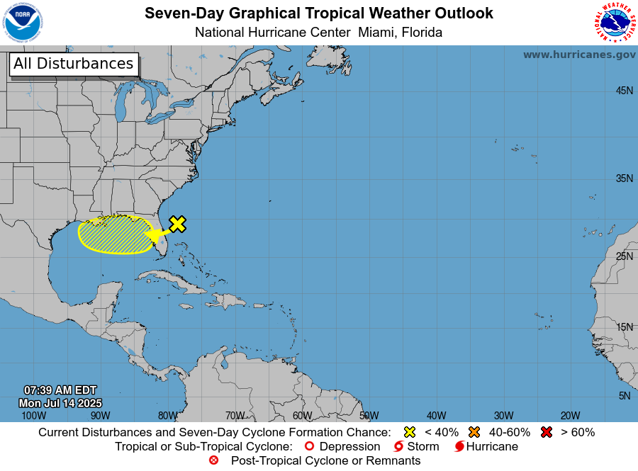
The remnants of a front, currently in the Atlantic Ocean off the coast of Georgia, should move across Florida over the next day or two, and into the northeastern Gulf. Once there, conditions could support the development of this area of low pressure into a depression or tropical storm that would continue moving generally to the west.
As to what happens after this, there is not great clarity in the model guidance. The background conditions, including sea surface temperatures and wind shear, are somewhat favorable for organization and intensification. But this is not an ideal situation, and the system is likely to remain fairly close to land. So we don’t expect this to explode over the deep and warm waters of the Gulf. Eventually it should move toward Louisiana.
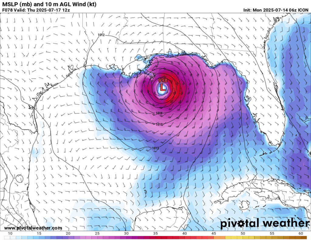
One outlier model that appears to be most bullish on the system is the Germany based ICON, which brings a moderate tropical storm toward southern Louisiana by Thursday morning (shown below). Some people may remember that the ICON model is one of the outliers that correctly predicted Hurricane Beryl would impact Texas about a year ago, so we are not completely dismissing it. However, most of our other guidance does not develop a tropical storm, but rather keeps this at a disturbance or a depression level.
So in terms of intensification what we can say right now is that we don’t anticipate a significant wind storm. We cannot rule it out, but high winds and storm surge are not the main talking point. Rather, rainfall potential is.
Precipitation outlook
As this system tracks across the northern Gulf of Mexico, it is likely to bring increased rainfall chances to the Florida Panhandle, southern Alabama and Mississippi, and especially southern Louisiana. For now, NOAA’s Weather Prediction Center has that area, including New Orleans, under a “slight risk” of excessive rainfall next Thursday (shown below) and Friday.
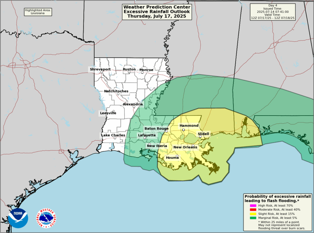
That’s a good starting point, but depending on the evolution of this system that estimate may need to be bumped up in a day or two. The bottom line is that the second half of this week could bring a significant amount of rainfall into Louisiana. Right now we can only monitor the risk, rather than provide a definitive forecast. Hopefully that changes in a day or two.
As for areas further west, including Texas, we cannot rule out impacts at this time. However, none of our reliable guidance shows this system (or its heavy rainfall) tracking far enough to the west to bring heavy rains or winds to Texas. But it is something we will continue to watch.
For NOLA to Houston, are the sea surface temps warmer than around the Florida panhandle, in other words, as the track updates westward this week, does this system get both more time over water plus rising water temps?
water temps are warm right now, too early on precise tracking right now to determine potential strength of storm. best to wait on further updates
Hmmmmm…
Ty Matt ⚘
Please update your TikTok. All kinds of minor fear mongering about this potential storm is starting up and your last post was about Milton.
Does this Gulf system have the same track forecast problem as Beryl?