Headlines
- No major forecast changes with PTC 9/future Helene this evening.
- A major hurricane is now explicitly forecast by the National Hurricane Center.
- Watches now extend up to the Florida Keys.
- Impacts in Tampa are expected to include tropical storm force winds and some degree of storm surge. This post examines how bad that could theoretically get and how that might happen.
Helene/PTC 9 forecast update
The overall forecast is generally steady this evening versus this morning, so not a whole lot has changed. The NHC is now explicitly forecasting Helene to become a major (category 3+) hurricane on approach to the Florida Panhandle.
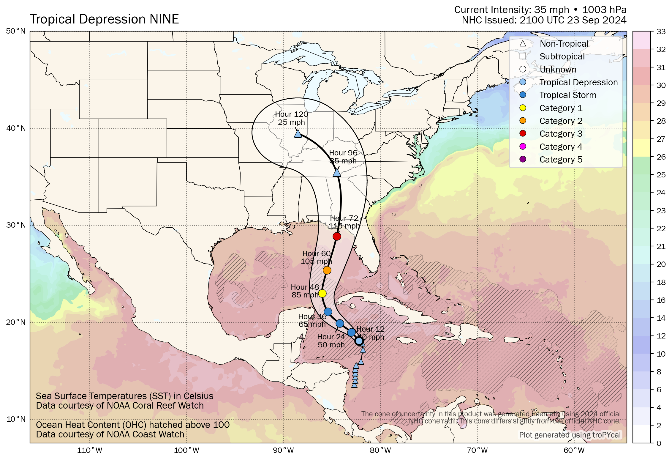
The current forecast track takes it to the west side of Apalachee Bay, which would likely produce a substantial, very bad surge in Apalachee Bay and points east around the Big Bend and Nature Coast. With some models indicating this could get even stronger, that surge risk is going to be extremely bad. I need to underscore that for folks in Florida’s Big Bend, we know you have been through several storms in recent years. This one has a higher ceiling than those it would appear, meaning the surge impacts could be as bad or worse than anything you’ve experienced in the last several years. Just keep that in mind.
The timing is mostly unchanged today, and we’re looking for a Thursday evening landfall in Florida right now. The cone extends from about Destin through Tampa. It’s important to recognize that 72 hour forecast errors are significant enough usually that storms can deviate considerably. Just ask Houstonians how Beryl’s expected track into Corpus Christi and South Texas changed this year. So if I lived in Tampa right now, I would be taking this as seriously as anyone on the Panhandle or Big Bend.
Let’s talk about Tampa Bay risks
Assuming a track as forecast by the NHC, tropical storm force winds are likely in Tampa, and there is some potential for hurricane-force winds on the immediate coast in Pinellas or Pasco Counties.
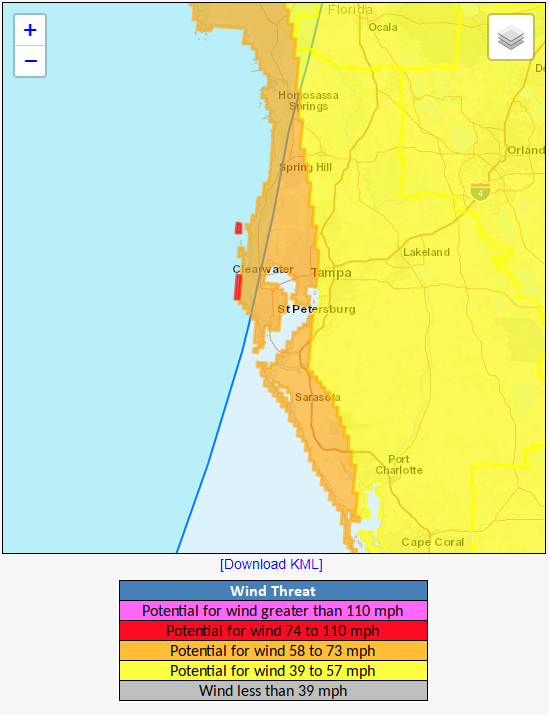
The issue is that if this shifts any farther east, which is something the ICON model hints at with a landfall more in the Big Bend than in Apalachee Bay, then the risks increase drastically in Tampa both from a wind and surge standpoint.
Speaking of surge, the NHC publishes storm surge inundation maps that show reasonable worst-case scenario outcomes. These maps are not the *likely* case, but they are the outcome that could occur in a worst-case, something that has about a 1-in-10 chance of occurring. For Tampa, this would sort of like if the ICON model came to pass, and the storm made landfall just up the coast rather than in the Panhandle.
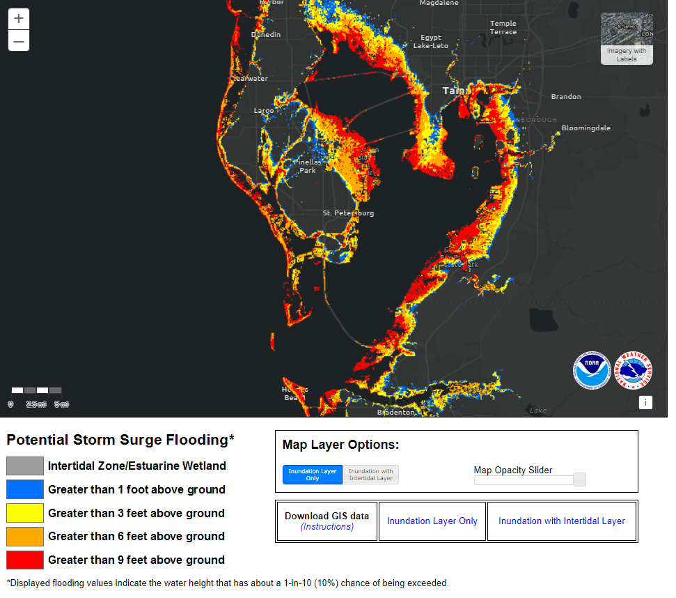
The map suggests some rather significant inundation potential in and around Tampa Bay in this worst case outcome. This is one reason why I want to just make sure that folks in Tampa take this very, very seriously. As noted, this probably won’t happen, especially if the current forecast remains unchanged, however there is still enough uncertainty out there that it’s not a scenario I would be willing to discount at this point.
Anyway, this is one of many different storylines we need to follow with this storm, including the coastal impacts in Florida at landfall, the inland impacts in Georgia and South Carolina and elsewhere from wind and rain, the east coast impacts, and so on.
Currently, Hurricane Watches are posted between Cabo Catoche and Tulum on the Yucatan and Pinar del Rio in Cuba. Tropical Storm Warnings are in effect for Grand Cayman, much of the eastern Yucatan, and Artemsia, Pinar del Rio, and the Isle of Youth in Cuba. Tropical Storm Watches are in effect for the Keys. Those will be expanded northward later.
We’ll have more for you in the morning.
Great info, Matt ⚘
Thank you for all your hard work and accurate reporting.
It’s been a wild week watching this go from “signals suggesting something wants to form down there” to now expecting a CAT 3 to hit Florida.
Thank you for keeping us posted each day as I have friends in the panhandle. And I want to make sure of location etc. for them.
Is there a possibility that the front coming over Texas will stall and not push the hurricane as far East? Thanks
No…it will stay in the eastern Gulf.
Thank you. I have family on the Tampa area and have been sharing your posts. They got into preparation gear today.
At this stage, what would you say is the outlook for Charleston, SC? Should I reconsider flying there on Thursday evening and planning to stay through the weekend?
It’s a tough call. You should be able to front run the storm in. Friday will be a rough day, but then the weekend looks fine. So depends how much tolerance you have for a bad weather day.