Today marks the first day of what is expected to be a very active hurricane season in the Atlantic Ocean. You’ve seen the forecasts. You’ve heard probably more than you care to hear about it. Today, I just want to ground everyone a bit.
Headlines
- Hurricane season is officially underway, with a very active season expected
- La Niña is still expected to develop, and water temperatures in the Atlantic are historically warm
- There are ways this season can be not as bad, including the 2010 path, a slower La Niña, or some other known unknown
Realities of 2024
Look, the reality is that the data is the data. We are likely heading into a La Niña, which has historically led to busier than normal Atlantic hurricane seasons.
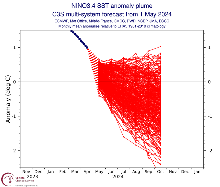
That’s about as strong agreement as you could ask for to have confidence that a La Niña was going to develop by mid or late summer.
The Atlantic Ocean is absolutely raging warm right now. The most important initial ingredient for tropical systems to develop is warm water, and we have plenty of it out there.
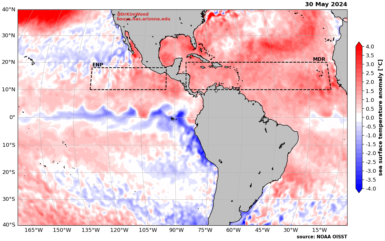
At this point, the entire Atlantic is warmer than normal where it matters, and some places are already even above their peak climatological values, normally reached in August or September. So, yeah, people aren’t hyping this, the Atlantic really is that warm. We are in somewhat uncharted territory here.
These are two very key reasons that explain why seasonal forecasts are what they are.
Reasons to not curl up in a ball in the corner of a room just yet
I just got done explaining why this season was likely to be extremely active. Despite realities being what they are, there are ways that the forecasts may not come to fruition, or perhaps come to fruition in a less impactful way.
The 2010 pathway
While it was not a top 10 year, the 2010 Atlantic hurricane season was still one of the busiest ones on record, qualifying as extremely active. As busy as it was, the impacts from the storms that season were far less than they could have been, given the activity.
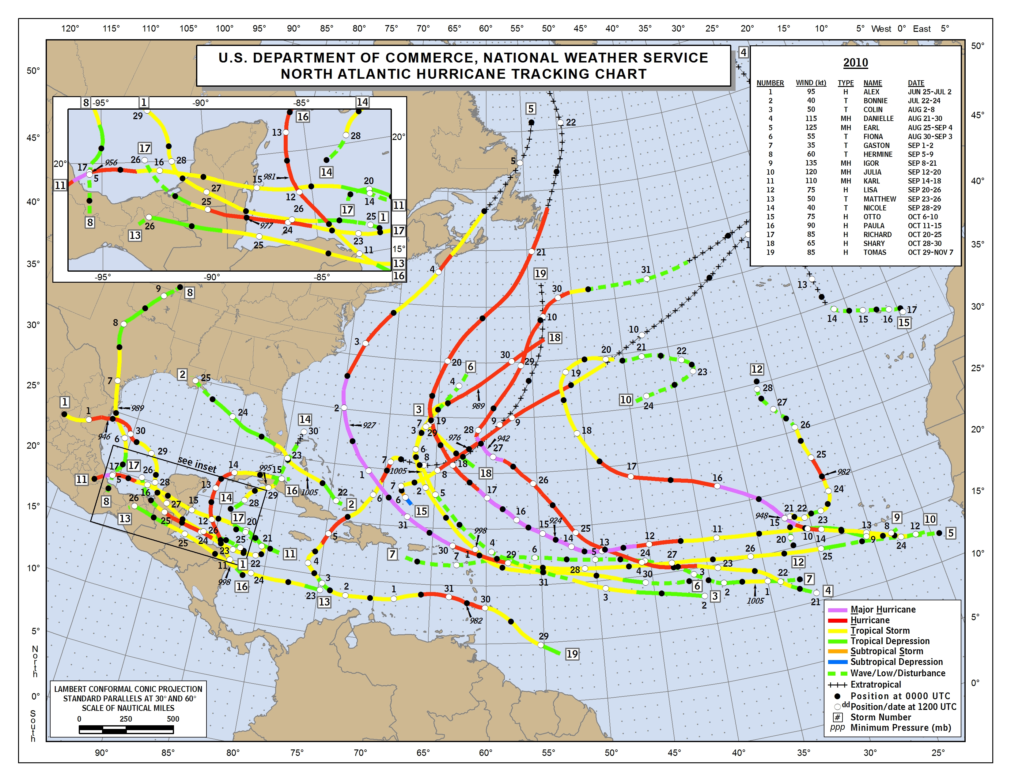
Hurricane Igor was a very bad storm in Newfoundland, one of their worst in years prior. Early season Hurricane Alex was particularly bad in Mexico, as was Hurricane Karl. Hurricane Tomas was also terrible in the Caribbean, especially in Haiti, which was still reeling from their major January 2010 earthquake. Tomas and Igor were retired.
So why am I saying the 2010 scenario is positive? It’s hard to have a busy hurricane season without some degree of devastation somewhere. That’s the reality. However, given that there were 19 named storms, 12 hurricanes, and 5 major hurricanes in 2010, that the destruction was not even worse is somewhat incredible. The hope would be that a 2010-type outcome limits the amount of loss of life and property we could otherwise see this year.
What if La Niña doesn’t quite come to fruition?
We are likely heading for a La Niña this year. The NOAA forecast from early May showed about a 50/50 chance La Niña develops by mid-summer and about a 70 percent chance it develops by late summer or early fall, at the peak of hurricane season historically. Bear in mind, however, that a 70 percent chance of something happening also means that there is a 30 percent chance that it does not happen. Let’s say La Niña is slow to get off the ground over the next couple months and it finally gets going in October or November? Let’s say we get into a firm ENSO neutral or “La Nada” situation heading into fall? These are not high probabilities, but they’re not inconsequential probabilities either. Will it prevent this hurricane season from being active? Probably not. But could it trim a little off the top, so to speak? Sure. It’s not an impossibility by any means.
Known unknowns
Seasonal forecasting is hard though not impossible. And hurricane forecasts have been rather spectacular in recent years. NOAA and Colorado State do good work. But there are frequently “known unknowns” that will show themselves. What if there’s persistent wind shear somewhere this year? What if there’s a lack of mid-level moisture to help storms thrive? What if like last year, most entry points to the western Caribbean and Gulf are closed off due to high pressure? There are a million “what if” questions we could ask. That could help mitigate the damage potential from storms this year.
Final words
As we begin the long slog that is hurricane season, we know that it is likely to be active. That much is certain. But there are ways it’s active and not as bad as it could be. And there are ways it may not even be as active as we fear. That’s the reality of long-range forecasting.
That said, hope is not a strategy, and if you are in a hurricane-prone location, you should prepare (as you should every year) for the season ahead. Not everyone has the luxury of being able to make elaborate hurricane season preparations, so look out for each other and continue to keep tabs on things. We will have more to come through the season!
Very good overview of the hurricane season. I live in West Central Florida. We have excellent meteorologists locally, on TV and, of course, the NHC in Florida. I still appreciate your take on this subject, which adds significantly to understanding climate/weather issues. Keep up the good work!
Much appreciated! We aim to be a supplement to everyone’s local information, not the primary source on what to do, but a primary source to help provide context, explain uncertainties, etc.
Thank you for pointing out the realities of the upcoming hurricane season!
And, when you are considering designs for your annual fundraising tshirts, could you consider your phrase “the reality is that the data is the data” !? ☺️
HA! We’ll have to consider that!
Thank you Matt. I have been looking forward to your update for the beginning of the hurricane season and true to form, you have helped alleviate some of the anxiety from the hype. Yes. We know things change and these scenarios can be way off at this point in time, but we appreciate your optimism and giving us a little ray of hope that Armageddon in not just around the corner every day. We have had enough excitement these past few weeks to satisfy us. Keep up the wonderful work and hope you guys get a little rest soon.
Why did the development of La Niña suddenly come to a stop? The negative anomalies have been the same for about a week now. Is it normal for it to be stagnant for a small while as ENSO Neutral before continuing?
This is how it goes sometimes. The development is usually never linear. It’s a bunch of fits and starts trending in one direction. Nothing we’ve seen at this point suggests it isn’t going to develop, but like I noted in the post, there is always, always a chance it takes it time, stalls, or doesn’t develop as expected.
the position of the Bermuda high is one of the most important aspect on where the storms eventually goes depending on the strength of the high stronger or weaker regarding what storm developed and the position of the high
Thank you for your incredible reporting as always. This is helpful information. Where can we find the guide to figure out what supplies to keep on hand?
We have a page of preparedness links that we last checked in 2023. That is here: https://theeyewall.com/hurricane-preparedness-and-information-on-evacuation/ Any of these sites will have more locally focused information for preps and plans. I also recommend here in Houston this site: https://www.weather.gov/hgx/HurricaneGuide2024 Also plenty of good tips.
Wise words Matt. Thanks for the rational take on things as always.