Headlines
- The tropical wave in the Atlantic is unlikely to develop before at least Friday.
- Development after Friday should be slow as it moves toward the Bahamas.
- From there, numerous questions about which will determine if this system can up in the eastern Gulf or turn north off the Florida coast and where it goes from there.
- Interests between eastern Louisiana and the Carolinas should check in on this again in a day or two.
A dry tropical wave for now
You hear the term “tropical wave” tossed around by meteorologists and others all hurricane season long. But what is it, exactly? By definition, a tropical wave is “an inverted trough (an elongated area of relatively low pressure) or cyclonic curvature maximum moving east to west across the tropics.” Nothing in that definition says thunderstorms or rain or anything like that. So, yes, in theory some tropical waves can be dry.
When we look at the central Atlantic today on the traditional satellite imagery, we don’t see a whole lot that’s perceptible. There’s a wave there, sure; you can see some cyclonic curvature. When you look at water vapor satellite imagery, you can see it even a bit better, but where you see browns, reds, and oranges, that indicates the presence of a lot of dry air. Use the slider below to toggle between a visible and water vapor image of the central Atlantic wave this afternoon.
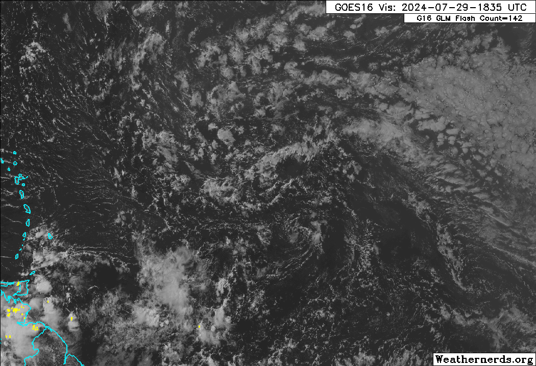
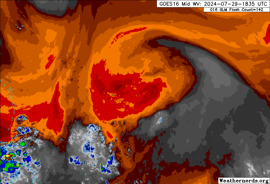
What does this tell us? It says that the tropical wave in the Atlantic is not going to develop anytime soon into a formal tropical entity. However, the presence of a tropical wave indicates that once it can shed some of this dry air, perhaps then we could see slow development. That may not be til Friday or the weekend.
Modeling continues to indicate the potential that the slow development noted above could occur as the wave comes west northwest toward the Bahamas or Turks and Caicos late this week or weekend. Clearly, it’s dealing with dry air and Saharan dust right now, but once it gets to the west, north of Puerto Rico by Thursday morning it will begin to likely increase moisture presence.
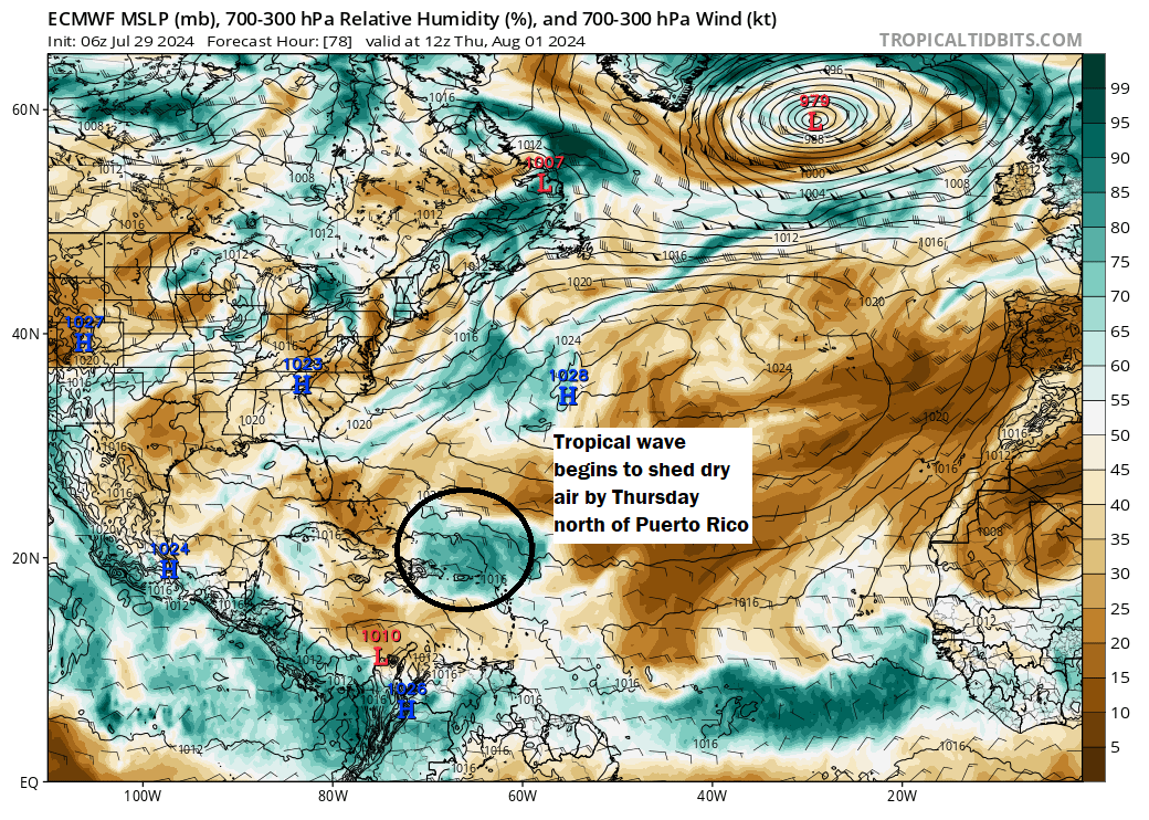
For the Lesser Antilles, Virgin Islands, and Puerto Rico, this system is unlikely to cause much heartburn. After Thursday, the system will continue to the west-northwest into the Bahamas. The overall atmospheric setup by Saturday as forecast by the European model is fairly complex, and as usual the ultimate path of this wave, depression, storm, whatever it is will be contingent on its strength as well as the exact location of these features. But at this point, I can count three big players: High pressure in the Atlantic, high pressure over Texas and the Plains, and a sharp trough of low pressure digging into the Ohio Valley and Appalachia.
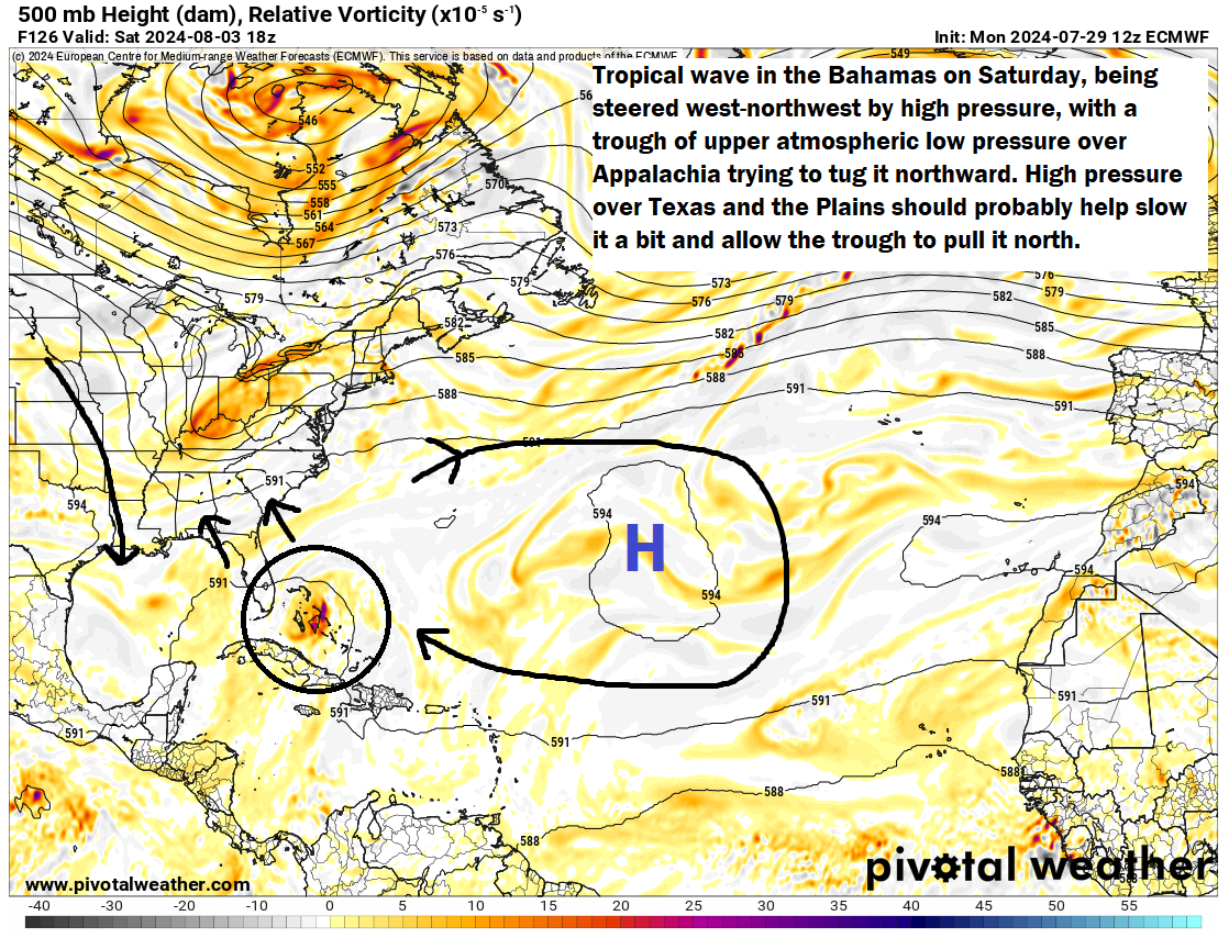
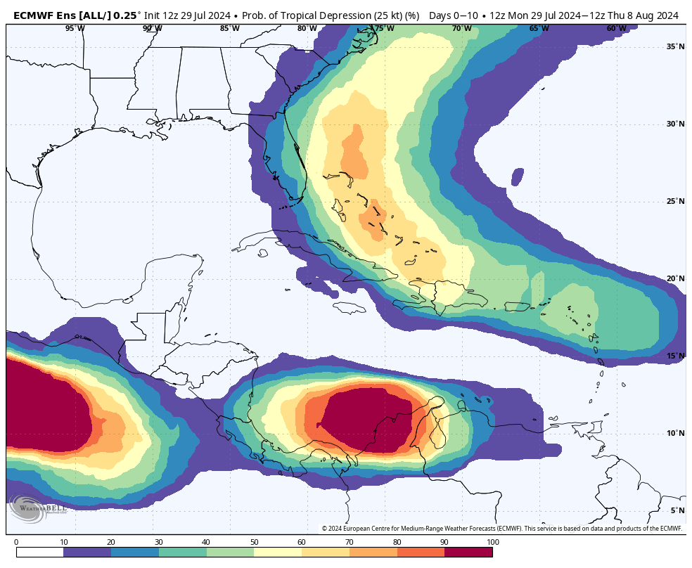
The interplay that the Euro is “seeing” here right now appears to be that the wave slows on approach to Florida. It is being steered by the high to the east, but it slows as it runs into the influence of high pressure over Texas (the arrow pointing down) and also as it “feels” the trough over the Eastern U.S. trying to pull it north. It’s tough to speculate much on exactly what happens here. A weaker system would probably keep drifting west into the Gulf, whereas a stronger one would be more apt to turn northward in the Bahamas and possibly stay off the Florida coast. Most European ensemble members have supported this stronger idea, and you can see today’s 12z probabilities of a tropical depression from the ensemble favoring the “off the East Coast of Florida” idea.
Beyond Florida, even in a faster turn scenario, all bets are off because the upper pattern may get a bit convoluted next week. An out to sea turn is not inevitable by any means in that scenario. Likewise, if a weaker storm sneaks under the trough and ends up in the eastern Gulf of Mexico, interests between Louisiana and the Florida Big Bend may be on notice too.
So, to summarize:
- Tropical development is not expected before Thursday or Friday at the earliest.
- Development is likely to be slow, though with exceptionally warm waters, any risk of development should be treated with respect.
- The best guidance we use favors a slowing in the Bahamas, followed by a turn north near or off the coast of Florida.
- However, given the very high uncertainty with regard to the speed of development and the precise location of steering features, any track forecast is low confidence and interests between Louisiana and the Carolinas should continue to monitor this system’s progress.
Elsewhere, no further tropical development is expected before mid to late next week, but we continue to look toward mid-August as the Atlantic inflection point, and activity may begin apace by then.
Hello. Excellent explanation of factors in play as I watch warily from the FL Panhandle. One question: How does the uptick in activity in the eastern Pacific influence this, if at all?
So the uptick in the Pacific should not influence this specific system much. However, with respect to the more significant increase in activity we expect around mid-August, that will play a key role. More storms that get going on the other side of Central America, a slightly less risk there would be on the Atlantic side. That said, we really don’t expect the East Pac to continue quite as active as it is expected to be over the next 7 to 10 days.
Is it true that if the path of a tropical storm or hurricane tracks to the north of San Juan, PR, the storm will probably not enter the Gulf of Mexico?
It’s not 100% true, but if you look at most storms that have tracked north of Puerto Rico, at least 80-90% of them have not made it to the Gulf. So if you’re looking for odds, that’s not a bad place to start. Eloise in 1975, Kate in 1985, and the 1926 Miami hurricane were a few that did make the crossing into the Gulf. Most ended up in the eastern Gulf but a handful also ended up in Mexico or far south Texas. The 1933 Cuba-Brownsville hurricane was one of the stronger ones: https://en.wikipedia.org/wiki/1933_Cuba%E2%80%93Brownsville_hurricane
Is it correct to think that Houston’s risk from this tropical wave is the same as it was at this early stage of the Beryl course of events?
I wouldn’t view it that way, no. There are other factors at play here. On the one hand, Beryl formed quickly in its life cycle from inception, whereas this will take much longer. On the other hand, most model data had projected Beryl to at least make it to the southwest Gulf, much closer to Houston than the eastern Gulf or Atlantic side of Florida, which is what is shown now. That, and the environment and steering currents will be markedly different this time around. Not to say it couldn’t come this far northwest, but the odds, even if low during Beryl’s early days are probably even a bit lower here.
Thanks
We are in Nassau until Friday morning. Should we just keep an eye on things for now?
Yes, but it should probably not arrive til after you leave.
Why does that map show a near 100 percent chance of a tropical depression forming between Panama and South America in the Carribean?
You know, I’m not sure what the algorithm is seeing there, but it’s probably an artifact. Or it’s interpreting another type of system as a depression. Either way, it’s probably meaningless from a tropical development standpoint.
Matt, I still feel like I don’t get what a tropical wave is 😳. Can you explain it to me like I’m five?
It’s like the wave at a football game. The folks standing are analogous to the warm air rising into the atmosphere, creating the surface low which is the trough.