In brief: Caribbean development odds from Invest 98L are increasing this week, but there are far too many questions than answers on its possible future in the Caribbean. We also take a look today at what could be a forthcoming significant pattern change for much of the Lower 48 just before Halloween, with an atmospheric river in the Northwest and the coolest air of the season so far in parts of the East and Central U.S.
Caribbean cruising with Invest 98L
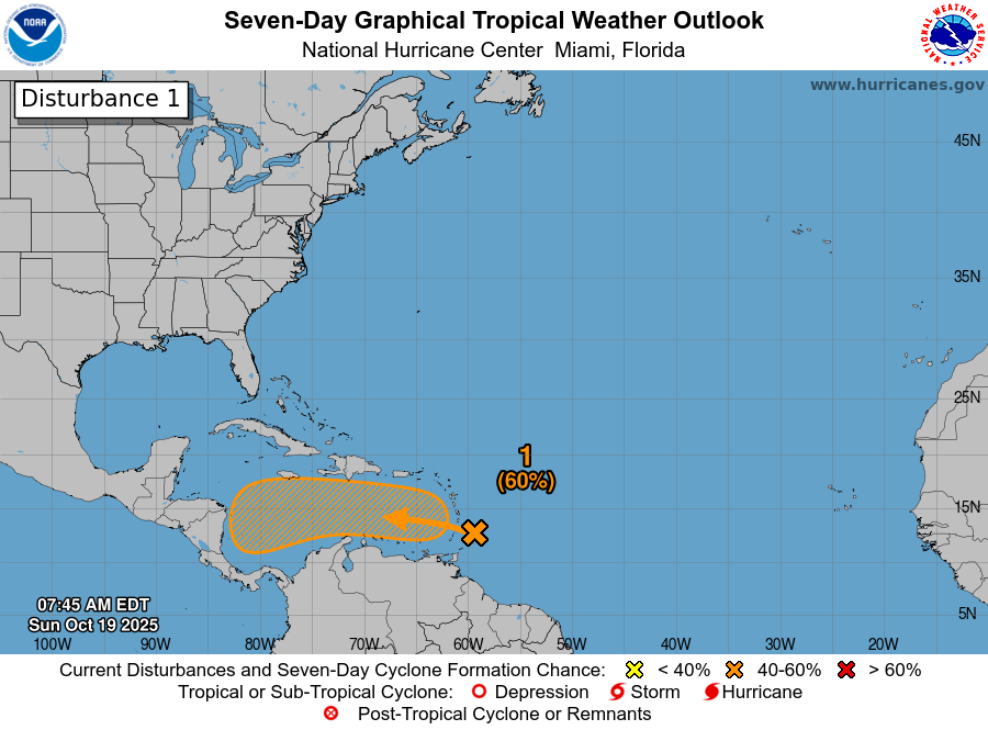
The area we’ve been watching for the Caribbean over the last week or so is now up to a 60 percent chance of development and is classified as Invest 98L.
60 percent odds of development exist in the Caribbean later this week. (NOAA/NHC)
As this races into the Caribbean, it probably won’t develop. However, by the time it gets about halfway across the Caribbean it will begin to slam on the brakes. This is a fairly common behavior of a tropical wave this late in the season. Once it slows down, then all bets are kind of off. We could see slow development into a tropical storm or hurricane. We could see slow, erratic movement. We could see nothing happen at all.
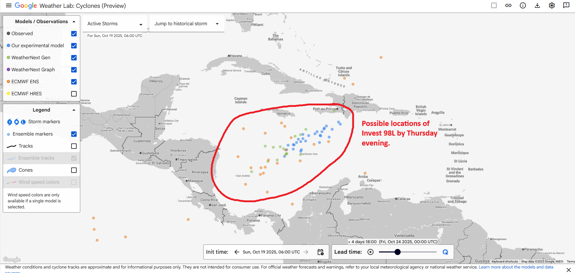
By the time we get to Thursday evening, Invest 98L will be somewhere in the central or southwestern Caribbean. (Google Weather Lab)
Based on the combination of Euro ensemble and Google AI modeling, it would appear that by Thursday evening, whatever Invest 98L will be is somewhere between the southwest Caribbean and Hispaniola. Some ensemble members keep hooking this north and northeast across Hispaniola or Cuba and out to sea. Others keep it buried in the Caribbean for a few days, eventually threatening Honduras or Nicaragua. Others still keep just drifting it northwest toward the far western Caribbean before eventually turning back north and northeast. It is unlikely to get into the Gulf given the time of year.
Given how warm the Caribbean is, and given the uncertainty of the track, it would be best for all folks from Nicaragua and Honduras up to Cuba, the Caymans, and Jamaica over to Hispaniola to monitor the progress of this disturbance through the week. Yes, large storms can form in the Caribbean in late October. Stay tuned
Major U.S. pattern change on the horizon?
We’re starting to see signs of a major shift in the weather during Halloween week, so beginning in about 8 days or so. You can see the change in the upper air pattern when we look at the Euro ensemble about 20,000 feet up from day 5 through day 11:
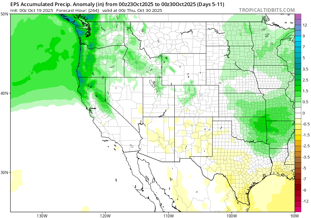
A significant push of moisture and cool air in the West (blue) will expand into the central and Eastern U.S. by the 29th or 30th.
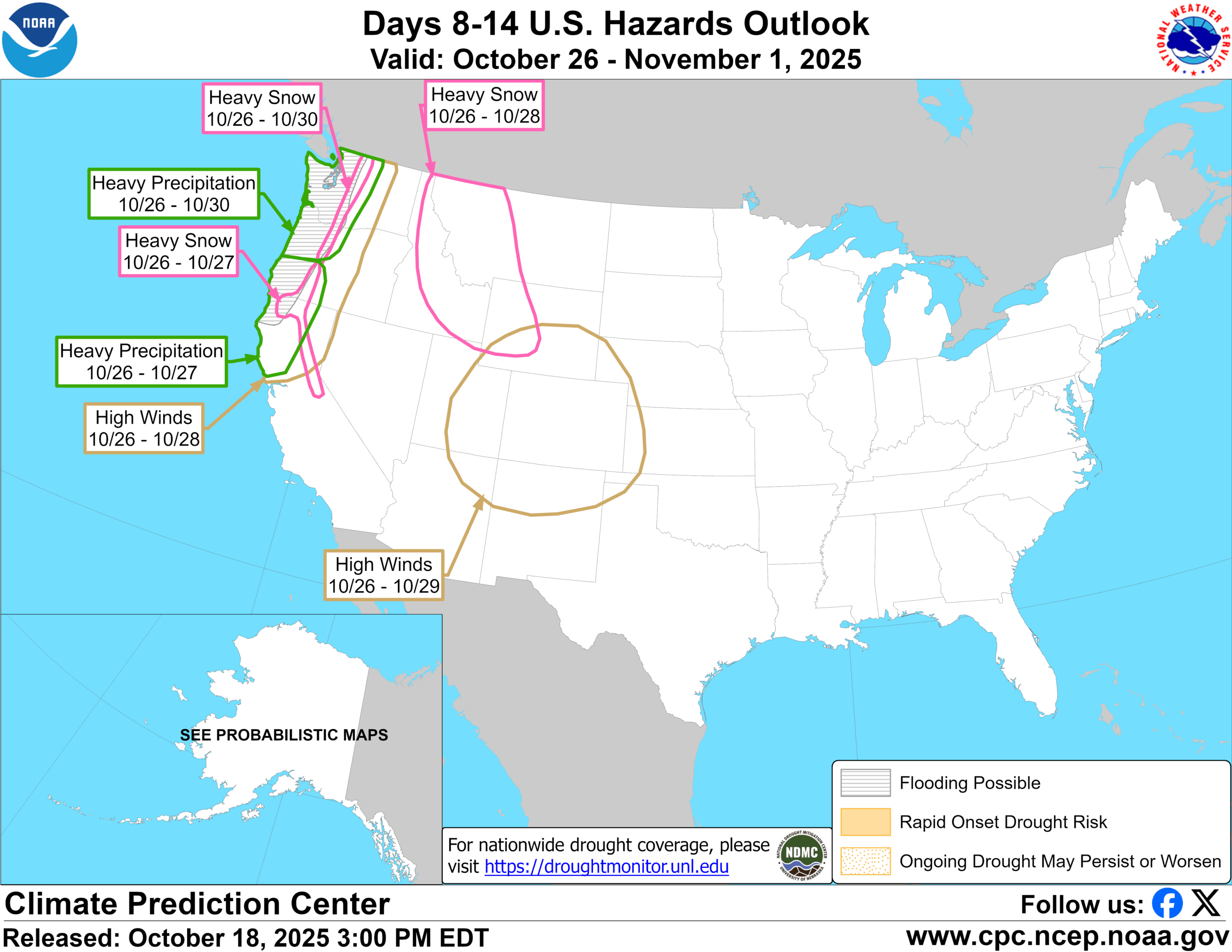
The 8-to-14-day outlook is highlighting a major precipitation event in the West that seems plausible with that upper air pattern.
The 8-to-14-day hazards outlook. (NOAA CPC)
In fact, you can see that precipitation anomalies as forecast by the European model are much above average in the Pacific Northwest for the 7 day period ending on the evening of October 29th.
Precipitation anomalies for the 7-day stretch ending on the evening of October 29th. (Tropical Tidbits)
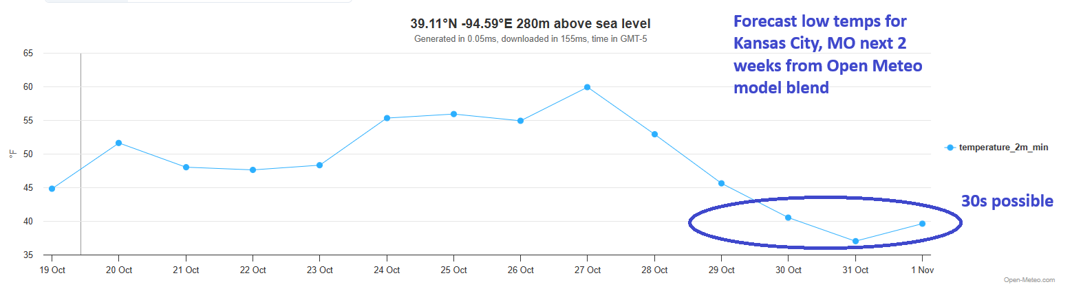
An atmospheric river will get things going here. Eventually, that will send a disturbance across the country, allowing for colder air to dump in from Canada. Much of the South has yet to have that “Wow, here’s autumn!” front yet, while much of the North has had some periodic colder temperatures. But it does appear that things will change next week with this system and cold front. Kansas City hit 43 this morning, their coolest morning of the season, but the current blended model forecast for Halloween is calling for 30s.
Kansas City should have their coolest morning of autumn right around Halloween. (Open Meteo)
We’ll see just how far south and east this can get, but it’s possible we see 40s in Dallas and Atlanta as well from this front (though Atlanta will probably see 40s tonight as well for the first time). Either way, it appears that at least a temporary pattern change is on the way for the Lower 48. Whether that sustains into November or we fall back into a milder stretch again remains to be seen.
In brief: Today we take a fresh look at the chances of Caribbean development next week. A lot of newsy stuff at the bottom today, including some discourse on how a lack of weather balloons may have impacted the storm forecast in Alaska this past weekend. Plus some good news and bad news as it relates to fallout from July’s devastating, tragic flooding in Texas.
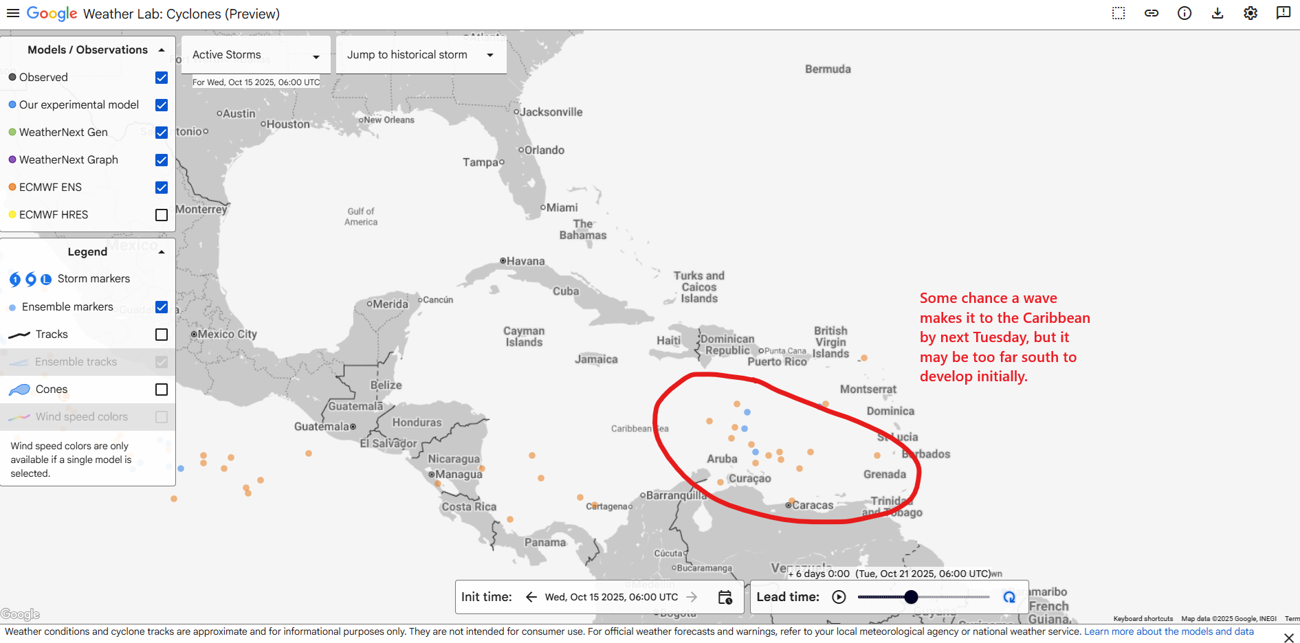
Caribbean risks remain non-zero but still somewhat low
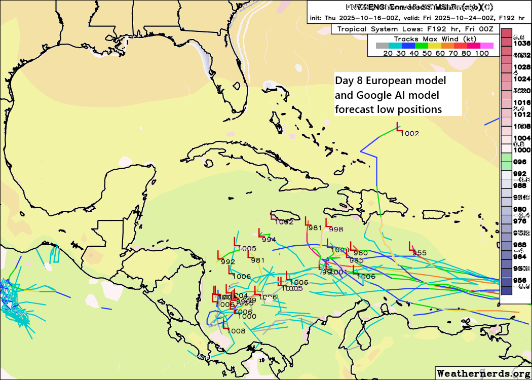
With the tropics now quiet, we can focus entirely on rampant speculation, which is to say the Caribbean. Let’s go way out to day 8, which is next Thursday evening.
Combination of the Euro ensemble and Google AI ensemble position of low pressure forecasts on Thursday evening the 24th. (Weathernerds.org)
Forgive the somewhat sloppy formatting, but I combined both the Euro ensemble and Google AI ensemble modeling on one map here. You can see that a minority of ensemble members support development in the Caribbean, and exactly where and how strong they get with it is also in question. What you’d typically see in this sort of pattern, I think, is that we’d have disorganized thunderstorms basically “fester” in this area for several days, and eventually they could congeal into a system that is slow moving in the southwest Caribbean. From there, it could drift inland into Central America and fizzle out, or it could come north or northeast. A lot of options are on the table. It could develop significantly or it could just be plagued by other issues to hamper its organization. Whatever the case, it’s something to watch but it remains mostly speculative at this point, without any real concrete risks to explain. We’ll follow along.
Newsy Bits
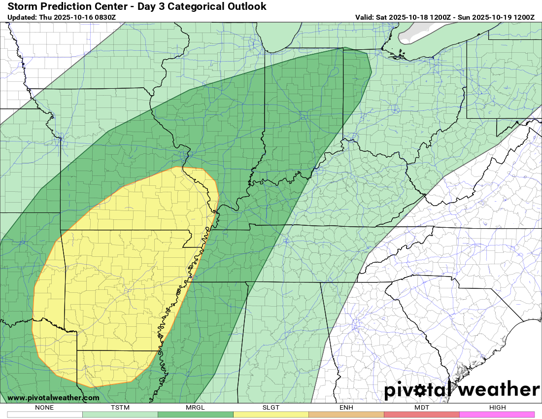
Our first real severe weather event of autumn may descend this weekend. Rather than reinvent the wheel, I will direct you to Alan Gerard’s writeup on this in his Balanced Weather Substack this morning. Fall often brings severe weather, especially to the Mid-South and Deep South, so it’s that time of year to begin paying attention.
Saturday’s severe weather risk extends primarily from NE Texas and northern Louisiana through the Missouri Bootheel to just south of St. Louis. (Pivotal Weather)
Alaska: Recovery and weather balloons
Recovery continues after this weekend’s horrific storm in western Alaska. There are still two missing and one person that was killed from the village of Kwigillingok. Schools are still being used as shelters as the recovery period begins. Thinking about recovery in rural, remote western Alaska, you have to reset your mind a bit. This isn’t going to be like a recovery virtually anywhere in the Lower 48. Life is challenging on a good day in some parts of Alaska, and this is the sort of recovery that is a logistical challenge. I strongly encourage you to read Rick Thoman’s piece linked there.
One thing we have discussed at times since spring is that the degradation in consistent weather balloon launches was not a question of “if” but “when” it would come back to bite us. While we were fortunate (to this point) to not see a hurricane in the Gulf, which particularly concerned me as the scenario we’d get burned on, it is entirely plausible, if not likely that the forecast for Halong’s impacts in Alaska was negatively impacted by a substantial loss of upper air data. As Rick points out, the storm deviated from model forecast tracks and sped up. Would upper air balloon data from St. Paul Island for example have helped better forecast the directness of the impacts? We need experiments to prove it, but circumstantially this is almost exactly what we would have expected to see with a lack of consistent upper air weather data. This is why a strong, fully funded and fully staffed National Weather Service is important. We currently do not have that.
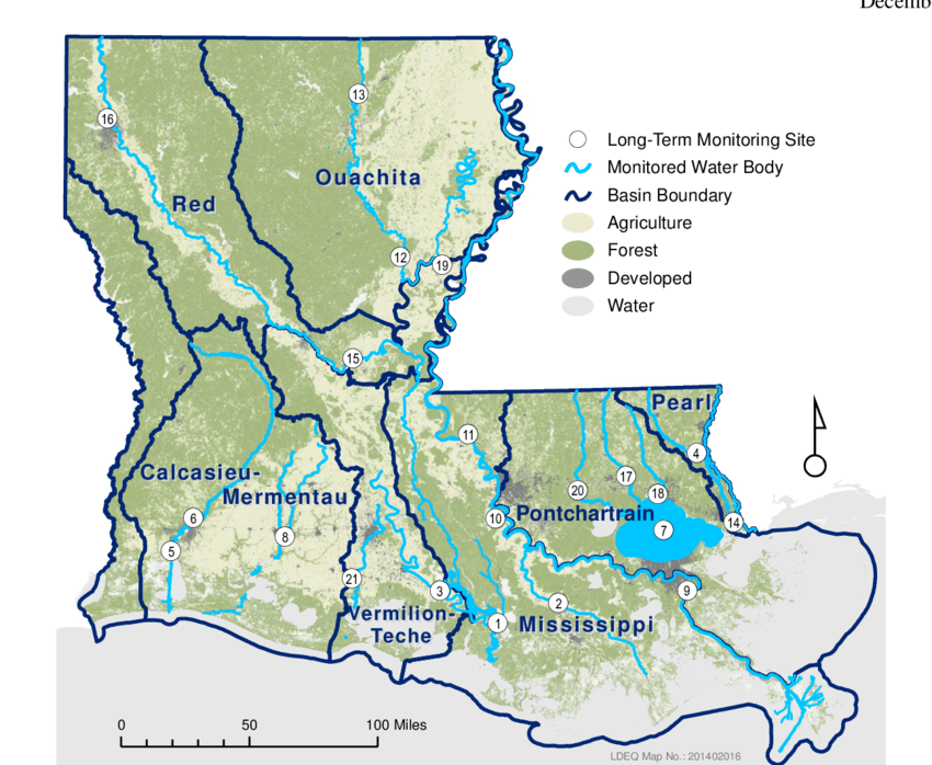
Louisiana: Flood mitigation plans should be regional
Map of Louisiana watersheds. (Putnam-Duhon, Lorna. (2016). Nitrogen and Phosphorus Trends of Long-Term Ambient Water Quality Monitoring Sites in Louisiana. 10.13140/RG.2.1.1631.5920.)
Mississippi coast: The cost of home ownership due to disasters
Mississippi Today has a deep dive on the insurance challenges and costs of home ownership near the Mississippi coast. While there have been tremendous strides in the wake of Hurricane Katrina 20 years ago, the vulnerability remains extreme. Large carriers like Allstate and Progressive have stopped writing wind policies there. And there’s now a vicious cycle where people cannot afford repairs and upgrades to help make their properties more resilient to storms, while their premiums keep rising, and the state’s lax approach to any new regulation hangs over it all.
Texas: Further investigating this summer’s flood tragedy
Some encouraging news in Texas. The summer special session of the Texas Legislature was completely overshadowed by the redistricting situation, but there were some notable, good elements related to this past summer’s flooding tragedy that came from it. Is it enough? No. But there will be more discussion and testimony on the event and trying to piece together more about what went wrong. The state is convening what they are calling the Senate and House General Investigating Committees on the July 2025 Flooding Events. This will be a joint panel on digging into what happened that will probably be able to move more slowly and with more detail than was allotted this past summer. Presumably, additional recommendations and guidance will be implemented as a result of what they uncover. Overall, I call it encouraging because it would be easy to say “We did something” after this summer’s session and move on. This suggests that there is more to come, and that’s a good thing.
Texas: Questions about FEMA eligibility
Some discouraging news in Texas from Emily Foxhall of the Texas Tribune. Only about 20 percent of all FEMA disaster applicant requests from Kerr County have been deemed eligible since the July 4th floods. Sarah Lebowitz who researches disaster for the Carnegie Endowment found that between 2015 and 2024, about 40 percent of FEMA applications are deemed eligible. 54 percent of applications from Kerr County haven’t even been reviewed beyond the initial stage. The Texas Tribune also found that the rate in Kerr County is well under the rates of other affected counties in Texas that are dealing with similar processes in working FEMA’s system. One reason they speculate on may be that people are struggling to work an online system in an area with spotty internet that’s still disaster ravaged. FEMA isn’t sending people door to door to help victims work through the system and process as they have in the past. This is likely due to budget cuts enacted under the current administration. The current shutdown is likely not helping matters.
Whatever the exact explanation, the story is worth your time to understand how nonprofits are helping fill (some) of the gaps. They can’t do it all however, and the process of navigating a post-disaster landscape can be maddening and full of additional hardship, particularly for people who lost everything and/or friends and family during the flood.
In brief: Tropical Storm Lorenzo will dissipate soon. We continue to see hints that the Caribbean would be the place to watch later next week, but we lack any strong model support for this even at this time. Something to watch but not worry over. We also wrap up some weather news from Alaska, Colorado, California, and Mexico.
Lorenzo’s demise and Caribbean development risks next week
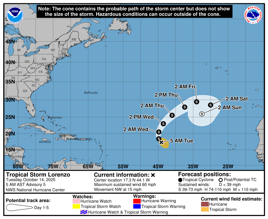
Tropical Storm Lorenzo is not long for this world. It is expected to dissipate later today.
Tropical Storm Lorenzo on its last legs. (Tropical Tidbits)
It may have already. Who’s to say? Either way, it’s a non-issue for anyone other than some shipping interests.
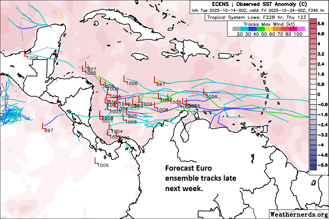
We’ve also noted that the Caribbean may see a tropical wave next week, and there has definitely been an uptick in social media postings about this area. Right now, I’m not especially impressed with model support for this area. I think one issue we are seeing is that it enters the Caribbean a little too far south initially. This proximity to South America may hinder any chance it develops. Here’s Google’s AI model ensemble members and the Euro ensemble members on Tuesday.
Perhaps this could develop, or it just may fester for a few days deep south in the Caribbean. (Google Weather Lab)
Once we get to later next week, there are some hints in the AI modeling that a disturbance could set up shop in the far southwest Caribbean, off the coast of Nicaragua or Honduras. As is typical for this time of year, movement would probably be slow and we’d be talking more about a rainfall risk than anything for portions of Central America (which as you’ll see below is not the best of news). But it’s a long way out and mostly speculative at this time. We’ll keep watching of course.
Newsy bits
I’m trying a section I want to call “Newsy bits.” I read a lot of news every day in order to keep up with what’s happening in weather and climate. Inevitably a pile of articles ends up taking up tab real estate, so in order to “keep it clean,” I’m gonna dump the tabs here.
Alaska storm recovery
First off, we noted the massive storm in western Alaska over the weekend. Well, if you want to help victims and survivors of the storm, I imagine it would be greatly appreciated. There is a post from Alaska Public Media explaining how you can help here. Very often, the best way to help is financially. The Alaska Community Foundation has setup a disaster relief fund for those areas impacted. You can access it here.
Defensible space in wildfire country
Unfortunately, the country has experienced numerous wildfire disasters in recent years. It has taught us a lot about resiliency and mitigation, however. One key element of mitigating wildfire impact and spread in communities is expanding defensible space around your home. Monterey is one of my favorite places on earth, and I found this interesting and encouraging. Defensible space inspections in the Monterey area have increased almost 300 percent year over year. The more that people do to help themselves help their communities, the better for everyone.
Colorado flooding
The Colorado Sun has the latest on the flooding in La Plata and Archuleta Counties in southwest Colorado. While the problems have been significant, the upshot is that some reservoirs are refilling after an exceptionally mediocre stretch of weather over the last year or so. Whatever the case, this was an exceptional, historic rain event for this slither of the country. The Land Desk also has a synopsis and more data on the flooding.
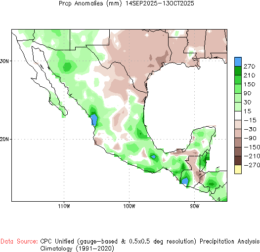
Mexico flooding
Major flooding has struck Mexico this month, which has thus far killed over 60 people across the country. This is a really messy story, not just because of the human toll and the disaster itself, but it seems to have been complicated by a bizarre situation with oil coating much of a flooded area in Poza Rica. There seems to be some anger about a lack of warning, and many people were only alerted to disaster by an oil company’s alarm system that they could hear. Not sure if there will be any fallout from this with their version of a national weather service.
30 day rainfall anomalies in Mexico, with parts of the west coast and Gulf of Mexico coast seeing significantly above normal rainfall. (NOAA CPC)
Mexico has been hit hard this summer with heavy rain on the order of 100 to 300 mm (4 to 12 inches) above normal in spots. Hardest hit has been the coast near the Gulf and the northwest part of the country.
In brief: Today we run down the storms that are impacting portions of the country. We have an update in Alaska, where a remnant typhoon caused horrific damage in rural western parts of the state. Major flooding is again impacting Pagosa Spring, CO this morning, even higher than this weekend’s flood. California continues to receive lots of rain and snow and even some severe weather. And the East Coast nor’easter is exiting. The tropics are of no consequence for now, but we will watch the Caribbean next week.
Alan Gerard has a good summary of the storm and some of the meteorology and forecast details (including asking the question about whether a lack of upper air weather balloon data due to budget cuts and staffing cuts within NOAA hindered the forecast at all). Read more at Balanced Weather.
Colorado
The San Juan River at Pagosa Springs is back up in major flood stage this morning, running about 0.1 to 0.2 feet above levels it hit this past weekend when it caused extensive flooding.
Major flooding is again occurring in Pagosa Springs, CO. (NOAA)
This is the third highest stage on record there, pushing this weekend to fourth highest. Rain totals above Pagosa Springs are nearly 7 inches since this weekend, which has allowed for this degree of flooding, prompting evacuations — again — in downtown Pagosa. More details on impacts from the flooding at the Colorado Sun.
California
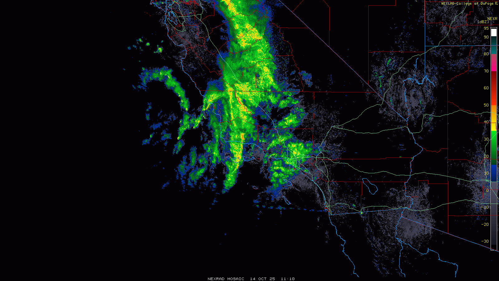
We had at least one tornado warning in San Luis Obispo County overnight, but a squall line offshore approaching the Los Angeles area this morning could cause additional strong to severe storms.
Radar loop ending around 5:45PT this morning. (College of DuPage)
Heavy rain and snow continue elsewhere in the state, with the Sierra likely getting a very healthy early season snow.
East coast nor’easter
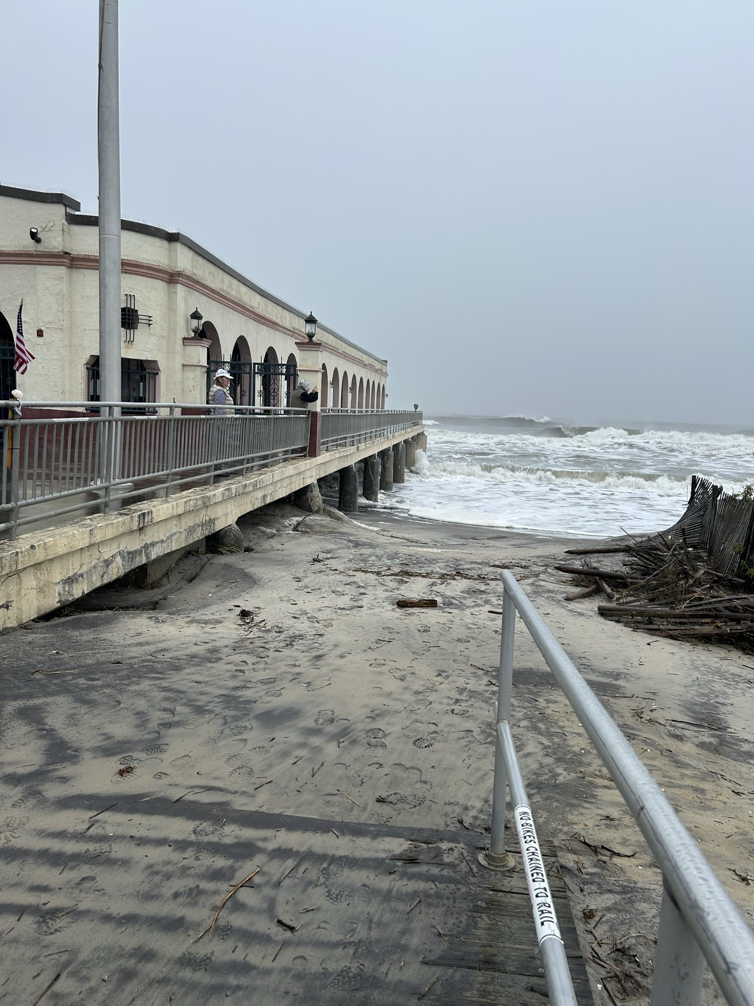
Most tidal gauges are now back below flood levels or are expected to experience minor flooding only today. Overall, tides may have underachieved some in this storm, but they still caused substantial damage.
Beach erosion evident in Ocean City, NJ yesterday; beach normally extends out several posts further on the Music Pier. (Pic via author’s mother)
Tidal levels in parts of NJ have not been this high since Sandy in 2012, though that brought significantly higher tides and waves. Still, this was able to do a number on vulnerable beaches. And at least 3 people have been killed as a result of the storm, including a freak, tragic incident in New York City.
Tropics
Lorenzo remains a non-issue this morning, as it will continue to meander in the open Atlantic, and as noted yesterday, it may do some funky maneuvering out there.
Lorenzo may be the 2025 Hurricane season’s class clown. (NOAA NHC)
There’s always one.
Meanwhile, we continue to see signs that there may finally be something in the Caribbean worth watching. Models have been up and down on this area for the better part of a month now, and it finally seems like we may have something. A tropical wave tracking west across the Atlantic won’t develop, but as it arrives in the southern Caribbean next week, it will have a chance to begin trying to organize.
The European ensemble, along with various other modeling tools suggest that development may be possible in the southern or southwest Caribbean later next week. (Weathernerds.org)
Will it happen? How strong will it get? Will it go into Central America or turn back north toward Jamaica, Cuba, or the East Coast? It’s too soon to say much of anything, especially “will it happen.” For now it remains it a late period curiosity like you’d find at a museum. Observe, don’t touch, and study it a bit closer for a few more days.