In brief: Near-record flooding is ongoing or forecast to occur north and east of Seattle today, tonight, and tomorrow leading to dire warnings in a few locations in western Washington. Another round of precipitation is likely next week, but the hope is that temperatures will cool off some, lowering snow levels and mitigating another wave of flooding concerns. Also below, we talk about record cold in the Midwest this weekend, and follow-up warmth in the run up to Christmas.
Pacific Northwest flooding focus
Let’s get caught up on the flooding in Washington State, where both the Snohomish and Skagit Rivers are going ballistic.
Check this video out from Snoqualmie Falls last night. Wild. This is not a typical Pacific Northwest rain. High snow levels and a double-barreled, prolonged category 4 atmospheric river event have triggered some extreme flooding concerns in the region.
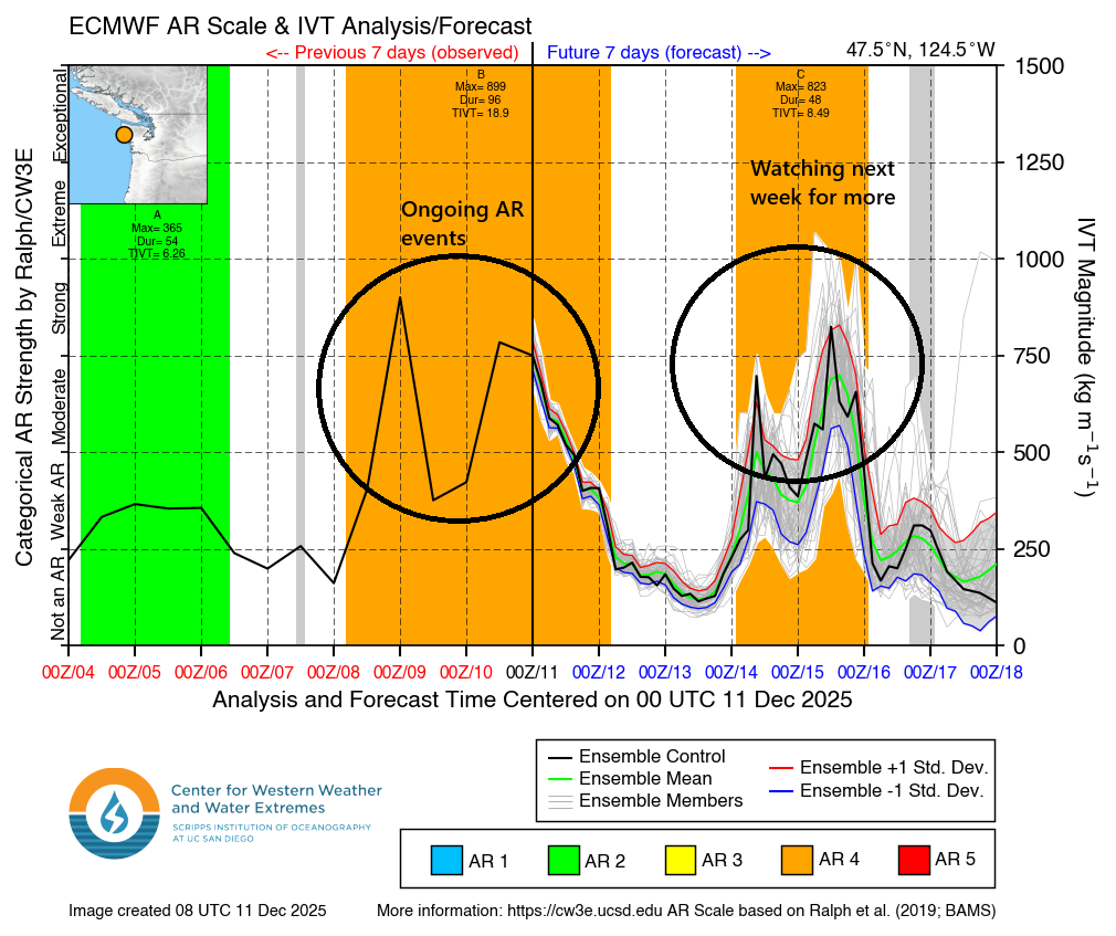
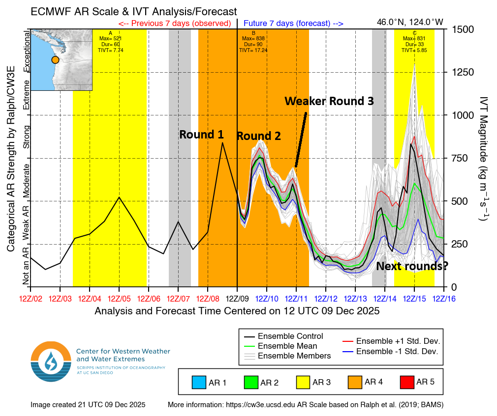
Washington State atmospheric river observations and outlook show a couple day-break awaiting before the next round of rain and snow. (Center for Western Weather & Water Extremes)
Rainfall over the past 72 hours has been quite extreme in the mountains, and much of the concern right now is because it’s so mild. The low temperature in Seattle yesterday was 53 degrees, a record warm low for the date, and only 3 degrees shy of the warmest December low temperature on record there. Snow levels have been up around 5,000 feet or higher in spots.
Rainfall over the last 72 hours ending around 9 AM PT on Thursday (NOAA)
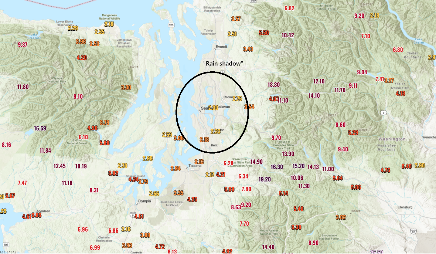
You can look at the map above and see a couple things. First, some of the mountains have seen north of 15 inches of liquid in the last 72 hours. 19 inches of liquid at the Lynn Lake SNOTEL site, all of it rain. Second, you can clearly see an Olympic rain shadow over the Seattle metro, which has spared the city of Seattle at least any real severe issues. However, all this water in the mountains? It has to go somewhere.
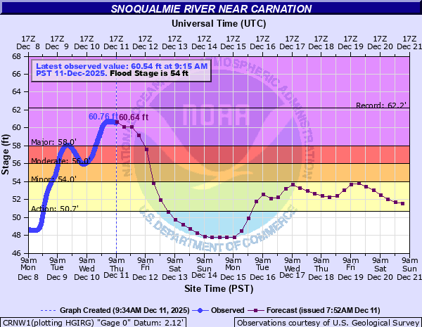
The Snoqualmie Falls video above is wild, and the water coming over the falls peaked around 70,000 cubic feet per second (cfs) last night, shy of the 78,000 cfs record. The river level was around 20 feet, which is just shy of the top 3 from 1990, 2006, and 2009. Downstream, the river peaked about 1.5 feet shy of the record at Carnation.
(NOAA)
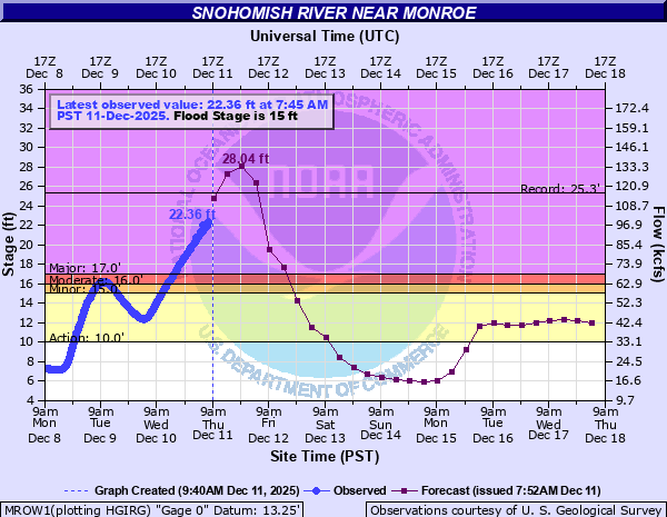
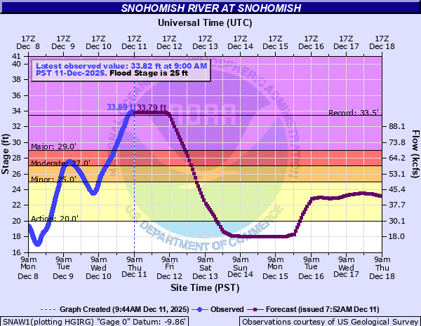
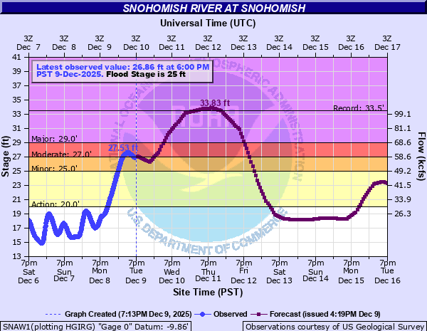
Meanwhile, on the Snohomish River at Monroe, a record crest is expected later today.
(NOAA)
The current forecast has it cresting about 3 feet above the record later today, but the current observed levels are running probably just shy of that pace. Either way, it will be near or above the record when it crests. At Snohomish, the river has established a new preliminary record crest of 33.89 feet, besting the 33.5 feet set in the 1990 flood.
(NOAA)
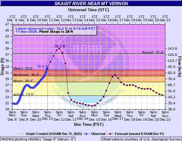
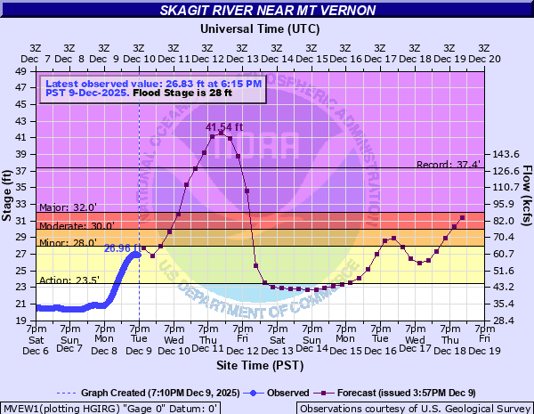
To the north, the Skagit River should crest a couple feet above its record levels. This forecast is lower than yesterday but still pretty catastrophic for this region. At Mount Vernon, we’re looking at around a 39 foot crest, compared to the record of 37.4 feet, also from 1990.
(NOAA)
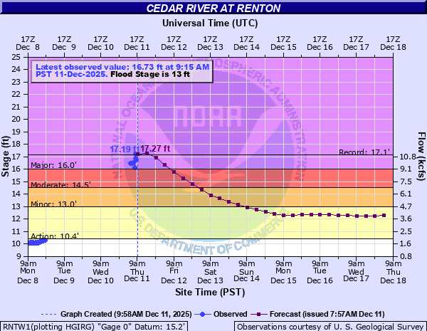
To the south, the Cedar River at Renton will also probably set a record tomorrow morning, when it reaches north of 17 feet.
(NOAA)
That river’s record? Also from 1990.As noted in this morning’s hydrologic discussion for the area, inundation near the rivers between Everett and Mt. Vernon is likely, and the threat of landslides remains as well.
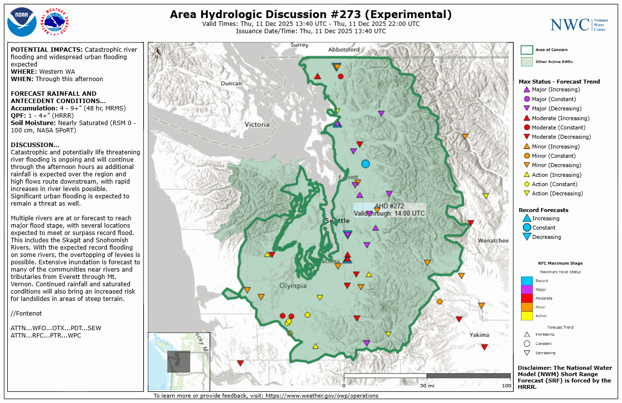
Hydrologic discussion from the National Water Center this morning. (NOAA NWC)
In addition, the NWS in Seattle has issued a flash flood watch for the Skagit River below Sedro-Wooley for dam and levee failure risk through Friday night.
Bottom line, it’s a mess, not everywhere but over a wide swath of northwestern Washington State. Flood warnings are also in place in parts of northern Idaho and Montana as well.
As things settle down tomorrow and Saturday, our attention will shift to the next AR event, which looks poised to crash ashore beginning on Monday or Tuesday. This one will start quite warm as well, but fortunately it does look like temperatures will drop off a good 5 to 10 degrees compared to the ongoing event. This should lower snow levels down to more typical elevations and lead to less of a full-scale runoff event like the ongoing one. Still, we will probably be looking at a fair bit of precipitation from this event.
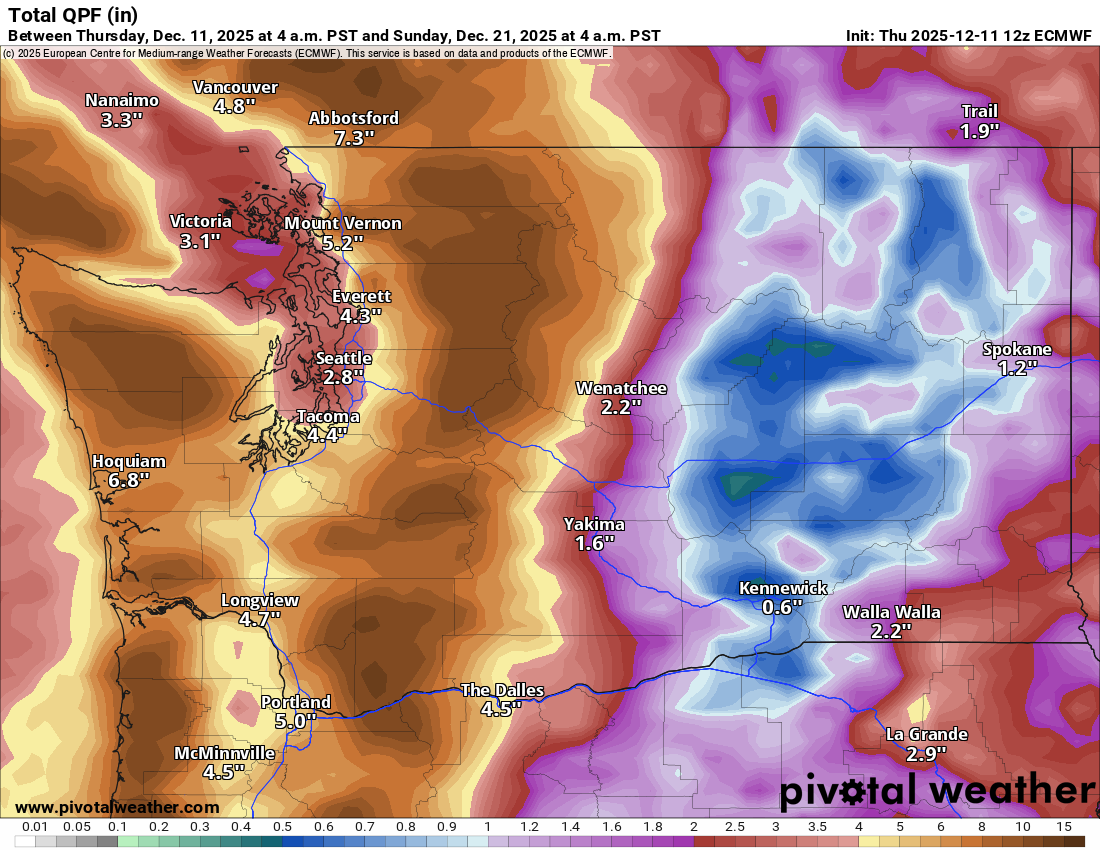
12z European model forecast liquid over the next 10 days showing anywhere from 10-13 inches in the mountains, much of it this time falling as snow. (Pivotal Weather)
Liquid equivalents will be on the order 10 to 13 inches in the Cascades next week, or as it stands now at least. While the amount of water flowing into the river systems will be mitigated by the snow that accumulates and sticks around, we will probably see another round of (less extreme) flooding risks next week in the Northwest.
Near record cold
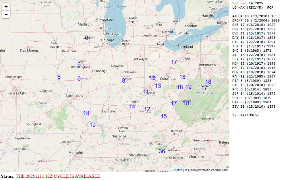
Meanwhile, as this whole pattern evolves, we get one last real serious shot of cold in the Eastern U.S. this weekend, peaking on Sunday. This one will probably be the coldest we’ve seen this winter across the Midwest, with numerous record lows being threatened on Sunday morning.
Record lows at risk on Sunday morning in the Midwest (NOAA)
Forecast lows will be near 8 degrees in Indianapolis, 14 in Louisville, 11 in Cincinnati, and 13 degrees in Dayton. Wind chills of -10 to -20 will be widespread in the Midwest with -30s in Minnesota.
Back to warm
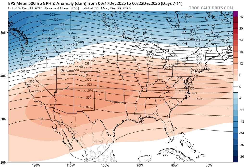
But thereafter, the pattern changes again. The 5-day average 500 mb height anomaly map is shown below for the period ending on Sunday evening, December 21st.
A broad, extremely warm weather pattern will expand across the southern two-thirds of the country late next week. (Tropical Tidbits)
A very broad, very strong ridge of high pressure will setup across the Southwest and Plains. This may be close to record strength for this late in the calendar year. That would translate to high temperatures, possibly numerous record highs and record warm minimum temperatures across the country in the days before Christmas. For cold, you may only be able to look to New England, the Pacific Northwest, and the extreme Upper Midwest. Stay tuned.
In brief: This evening we discuss the situation in the Pacific Northwest, with severe flooding developing. We also have a bunch of links to information on the recent news about the Colorado River, as well as an Eyewall curated book list to better fully understand the water situation in the West. That and more downstairs.
It’s been a minute. How are you? Good, I hope? Excellent. So one thing I had planned to do lately was write a rather thorough post about the Colorado River situation, which I personally believe is important for us all to understand. Instead, I’ve really just found so many other people, more well-versed than me on the topic have done outstanding work summing things up.
First, my contribution besides a bunch of links? I want to present a book list for you. I put this together on Bookshop.org (Full disclosure: If you order off this list, it may provide a small commission to us):
The West and Water: 16 books to help you better understand the water situation in the West
I curated 16 books that I have either read, am reading at present, or am intending to read. Each book on this list will provide some context toward understanding the water issues in the Western half of the U.S. If you need some holiday gift ideas for yourself or others, this may help a bit! Or so I hope it does. Anyway, it’s such an important topic, and I think it’s critically important that anyone with an interest in nature, water issues, survival of civilization, or the West broadly should read more to learn more. It’s a fascinating topic as well, and so much, so many competing interests are involved with it.
And it’s a mess right now…
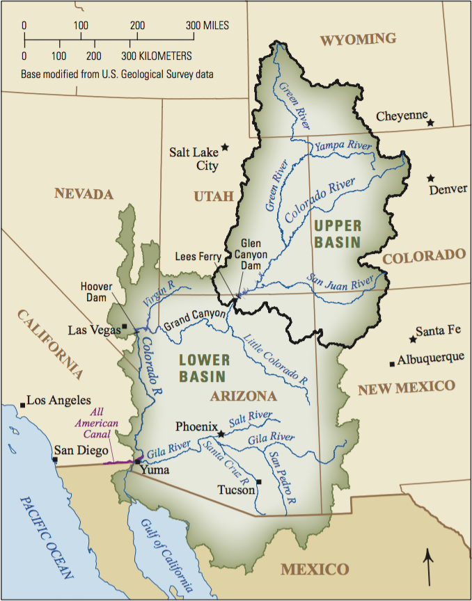
In 1922, the Colorado River Compact was established, which, in addition to numerous court cases and other laws and treaties decided since then has created what is known as “The Law of the River.” Key players have been negotiating on a new long-term operating strategy for the Colorado River. In 2007, Interim Guidelines for Lower Basin Shortages were established in response to increasing drought. Those rules have governed things since, and those guidelines expire at the end of next year. Thus, we’re in negotiations now. It’s a process that’s been ongoing for years now, and we just passed a key deadline on November 11th to reach an agreement. That did not happen. But if an agreement cannot be reached, the solution would come from either the federal government or the Supreme Court. Few want that, so they have opted to go into overtime on negotiations to try and avoid that outcome. Of course, not all feel this way. Arizona has stepped in and said they want the government to broker a resolution to the issues because, as Governor Katie Hobbs has put it, “Not only do they (the Upper Basin) refuse to commit to any water use reductions, they tell our negotiators that it is too complicated and impossible for them to reduce water use. And I have a really hard time believing that.” It’s messy.
The upper and lower basins of the Colorado River. (USGS)
So, how to make sense of everything? Here are some links.
That’s a lot of books and a lot of links, but this is SUCH a complex issue, to fully understand it you need all this context. Anyway, if you find yourself wanting to understand this better, that’s a lot to help right there. Hopefully you find it interesting and valuable.
Pacific Northwest major flooding
In the weather-world, it’s quite active. Right now, the focus is on the Pacific Northwest, which is getting absolutely crushed by an atmospheric river. Spike one just occurred this week. Spike two is inbound tonight and tomorrow.
Atmospheric river forecast (and past observations) from near Portland, OR showing the second round tomorrow, a weaker third round, and then another potential system after the 14th. (Center for Western Weather and Water Extremes)
This next round will deliver a substantial amount of rain as well as mountain snow. The snow levels will be up around 5,000 feet or higher, which is a fairly warm storm. These types of heavy precipitation events that are warm can cause serious flooding.
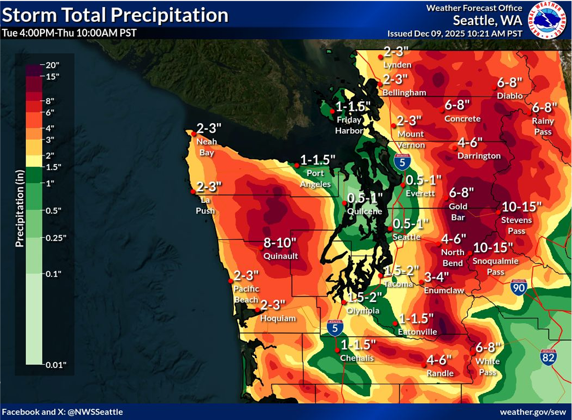
Additional rainfall expected over the next 36 hours or so in Washington State. (NWS Seattle)
The flooding will be major to record on some rivers. For instance, the Snohomish River at Snohomish will reach around its record level of 33.5 feet set in November 1990. The Skagit River near Mount Vernon will likely smash its previous record, also from November 1990.
River forecasts for the Snohomish and Skagit Rivers. (NOAA)
That Mt. Vernon hydrograph is rather concerning to be honest. Breaking a 35-year-old flood record by 4 feet is no small feat at all. The forecast can (and will) fluctuate based on how much rain actually falls, but it’s rather clear from the abundance of gauges near or above records that this is going to be a severe, if not historic flood event in western Washington. Landslides and debris flows in wildfire scars are also a concern.
Consult local media for a more detailed update on the situation, and follow the local NWS offices in Seattle, Spokane, Portland, and Pendleton for the latest. You can find the latest gauge forecast information at various locations in Seattle and elsewhere in Washington here.
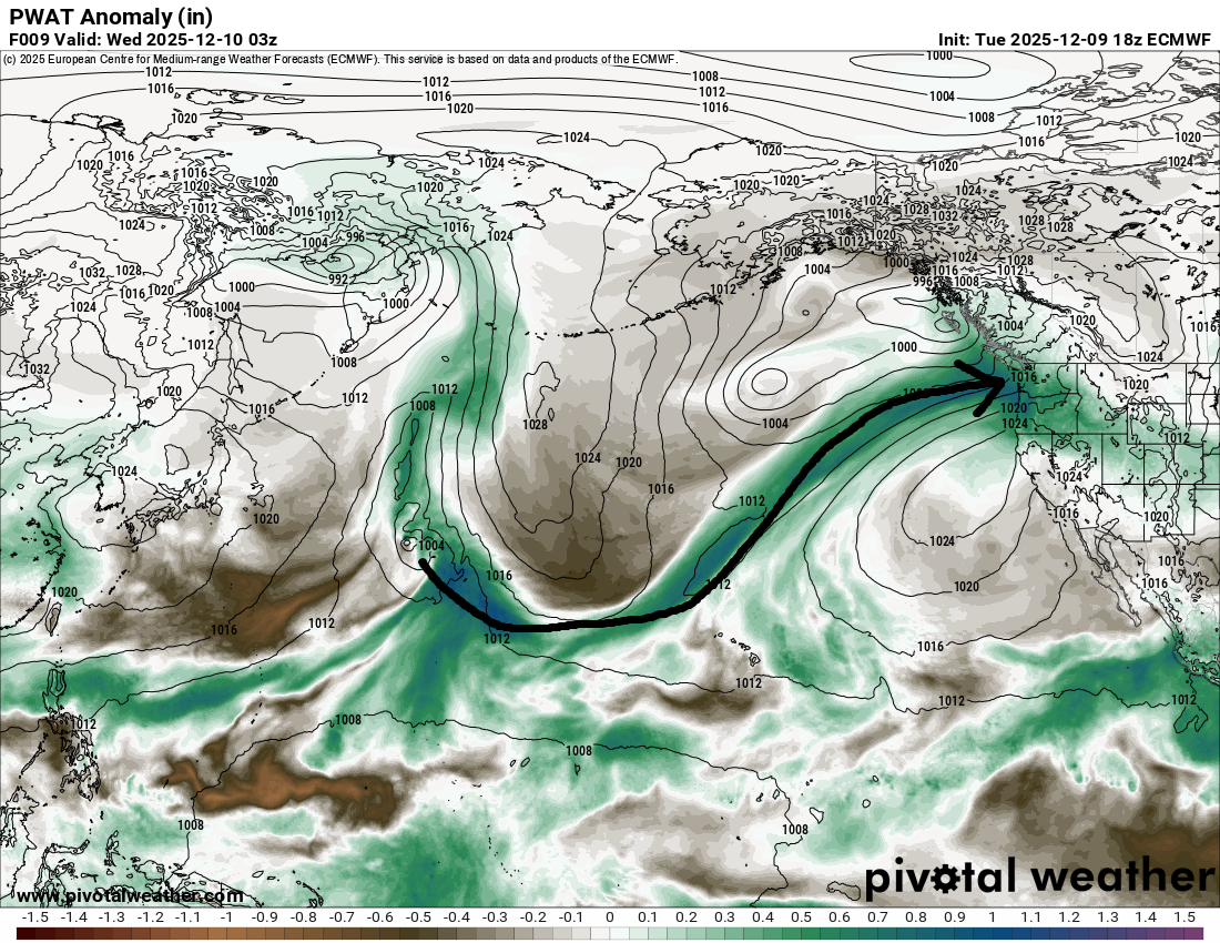
Everything is sort of connected here, and this particular atmospheric river extends way, way out into the Pacific. The first in this wave of storms extended back to the Philippines, an area that has also been dealing with severe rains this autumn. The next one in line is a little shorter, but it’s still extremely impressive.
A long, long atmospheric river will aim at the Northwest again on Wednesday. (Pivotal Weather)
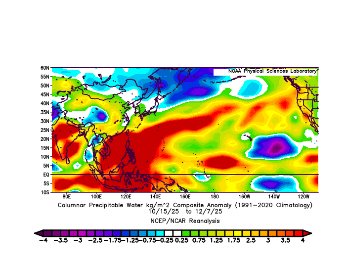
If you’ve followed weather globally, you’ve undoubtedly heard about flooding in the Philippines, Vietnam, Indonesia, Sri Lanka, Singapore, and elsewhere. In fact, if we look at how precipitable water anomalies have behaved since mid-October, it has been decidedly above normal from Southeast Asia across the Pacific into the Northwest.
Precipitable water anomaly from October 15-December 7th showing much above normal PWAT levels in Southeast Asia extending across the Pacific to the Northwest. (NOAA)
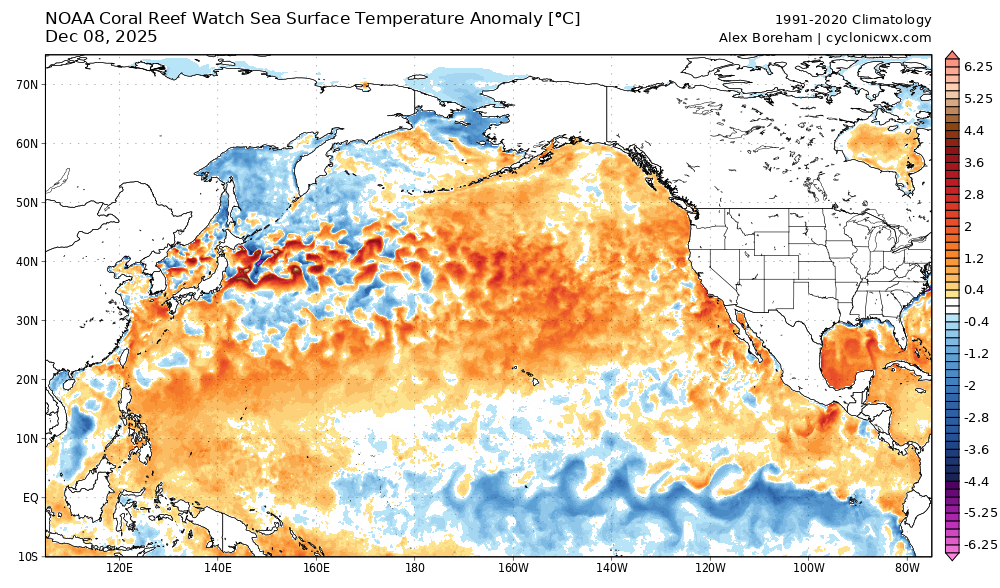
Clearly this pattern is juiced right now. The warm Pacific Ocean is not hurting this cause either. Warmer than normal water extends from the Philippines to north of Hawaii to the West Coast. It’s tremendously moisture-laden at the moment.
Warmer than usual Pacific Ocean waters are likely helping to contribute some to the atmospheric river event we’re currently seeing. (Cyclonicwx.com)
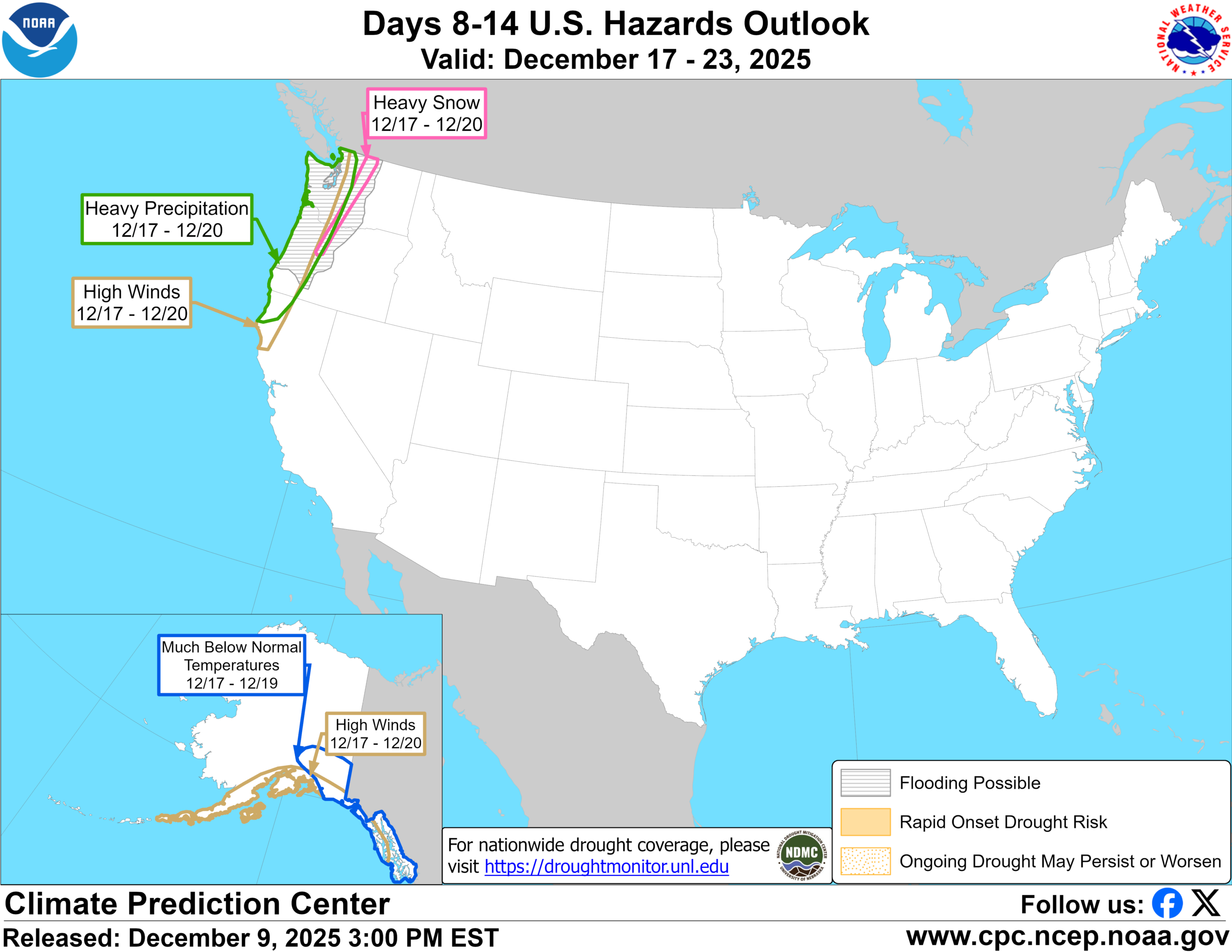
And the 8-to-14-day hazards outlook is once again highlighting the Northwest for potential heavier precipitation after December 16th.
Another significant atmospheric river event may unfold in the Pacific Northwest next week. (NOAA CPC)
This all shows up in modeling as well, both in traditional and AI ensembles. You can also see it appearing on the atmospheric river graph toward the top of this section. This may be a colder atmospheric river, which would be good news if it actually happens. While moisture is always welcome in the Western U.S., this sort of warmer setup helps only to a point, and it can cause more damage via flooding when it comes as a warm storm. Snowpack is like a savings account for the Northwest. The more snowpack, the more you can draw from your savings account in the warmer, drier months to generate hydropower and supply drinking water. If you just rush all that water through the system now, it becomes problematic and messy. Anyway, I’ll be keeping an eye on the Pacific Northwest in the days ahead.
Newsy Bits
Shaked Alaska
A magnitude 7.0 earthquake struck on Saturday in a seemingly odd place, on the U.S. border with Canada, north of Juneau and east of Anchorage. Kind of a fascinating case study, and thankfully extremely sparsely populated and remote so it likely produced no damage or injuries. What may be fascinating will be how it impacted the Hubbard Glacier, which sits atop the epicenter. I strongly suggest checking out the thorough review of the earthquake, with lots of great detail on the Earthquake Insights Substack (which you should also subscribe to).
Western Pacific AI model struggles
In the Pacific, there had been some buzz about another potentially large typhoon in the Philippines, with Google’s Deep Mind model being particularly aggressive with development. As Alan Gerard pointed out on Sunday, that has not happened. (You should also subscribe to Balanced Weather, as Alan has been covering that side of the globe closely too) Alan notes that he has heard from some in the field that Google’s AI model has struggled a bit in the western Pacific. I echo this as well. This is a fascinating case where the model seems to perform great in one basin but not another. That’s important information as a.) it underscores the limitations of AI modeling today; in other words, we’re not there yet to consider things “solved” and b.) it is helpful context to consider when developing new modeling. Is the solution that we need a new AI model, like GDM tuned to the nuances of the Pacific? Maybe. That’s where AI modeling *could* come in significantly handy; the resources and effort needed to develop a newer model with that consideration in mind would be substantially less and more efficient than if we stuck to traditional physics-based models. There’s work to be done, research to be done, and new tools to be had. Stay tuned.
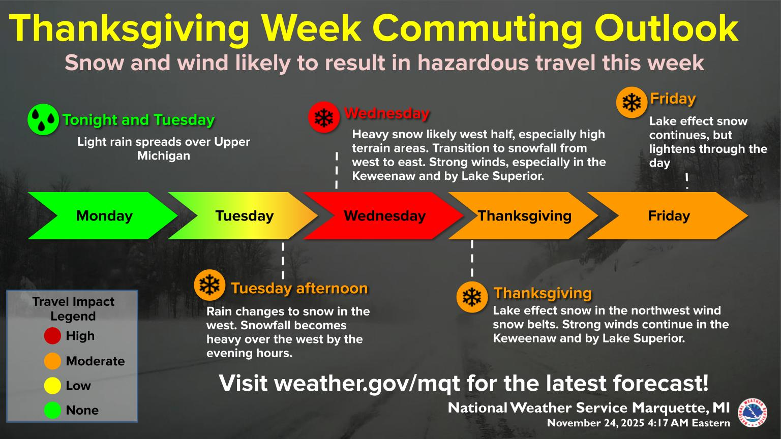
In brief: Travel on Wednesday doesn’t look too bad, but some strong winds in the Midwest or Great Lakes may be a hassle. Lake effect snow cranks up in the Lakes this week as well. After Thanksgiving, the forecast grows uncertain, with a lot of hype around cold that may or may not happen. In our newsy bits section, flood issues in New York City, massive protests in the Philippines due to flood mitigation corruption, and a visit to Hill Country 4 months after the tragic floods.
Pre-Thanksgiving travel
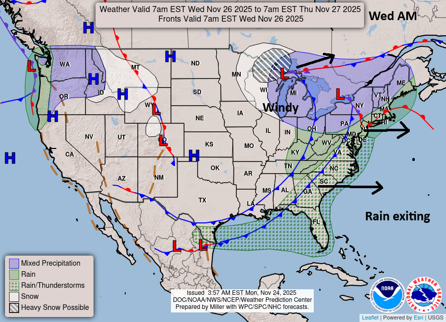
Let’s get you caught up on Thanksgiving travel risks for Wednesday across the country. A significant winter storm will track eastward tomorrow with heavy snow from the Northern Plains through Upper Midwest and into the Great Lakes. By Wednesday. the morning forecast map shows a cold front exiting the Eastern Seaboard with some lingering showers perhaps on the East Coast. A strong storm will be cranking over the Great Lakes or Ontario, which should rev up the lake effect snow machine in parts of Michigan and eventually east of there.
But from a travel perspective, the biggest issues will be that snow in northern Michigan and U.P., as well as perhaps some wraparound snow in Wisconsin. Strong winds may impact some flights in Chicago, Milwaukee, Indianapolis, Minneapolis, or Detroit. A few showers and storms are possible across Florida. Thankfully, the Northeast airports, Atlanta, Dallas, Houston, and most of the West Coast look fine. Hopefully this keeps delays and travel headaches to a minimum. For the most part, travel TO most destinations by air or car will be fine outside of those handful of areas.
Lake effect snow machine
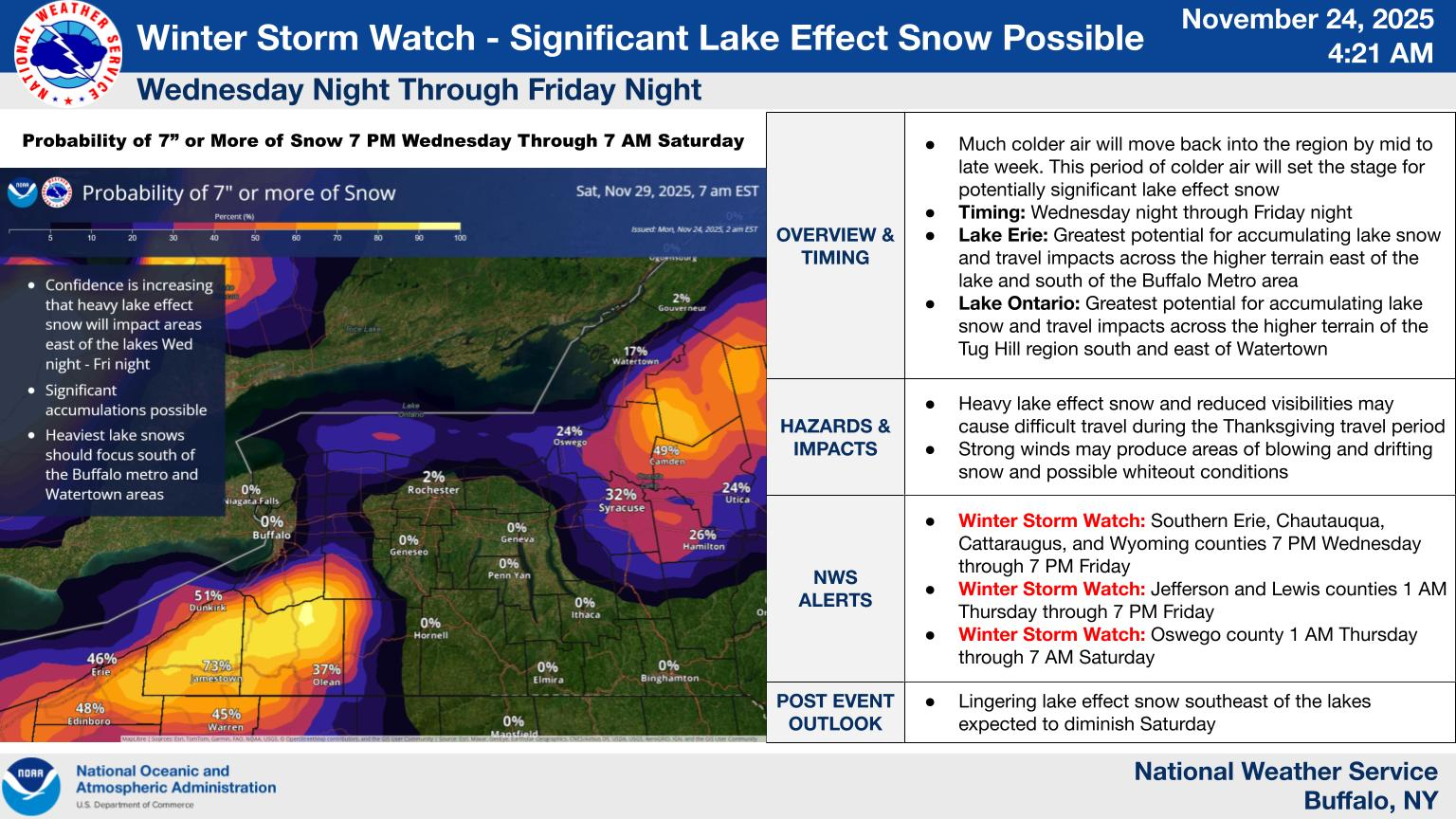
Heavy lake effect snow is possible in the traditional snow belts off the Great Lakes after Tuesday night and Wednesday morning.
(NWS Marquette)
Snow will crank in northern Michigan and the U.P. on Wednesday with northwest winds keeping the snow going in those snowbelts Thursday and Friday. Off Erie and Ontario, from Wednesday night through Friday we’ll see lake effect snow pick up as well, mostly well south of Buffalo toward Erie, PA and on the Tug Hill Plateau north of Syracuse and Utica.
(NWS Buffalo)
This doesn’t look like an epic lake snow event, but there will be some healthy totals surely, and holiday travel on Thursday or Black Friday travel may be impacted by the lake effect snow.
Post-Thanksgiving travel & cold?
It does appear that an active weather pattern will resume this coming weekend into next week. It’s a bit tough to pin down the exact track and impacts of any one storm system, but some sort of broad impacts from rain and perhaps a wintry mix will be possible Saturday into Sunday. Return travel may be impacted by this storm system, though again it doesn’t look too crazy right now.
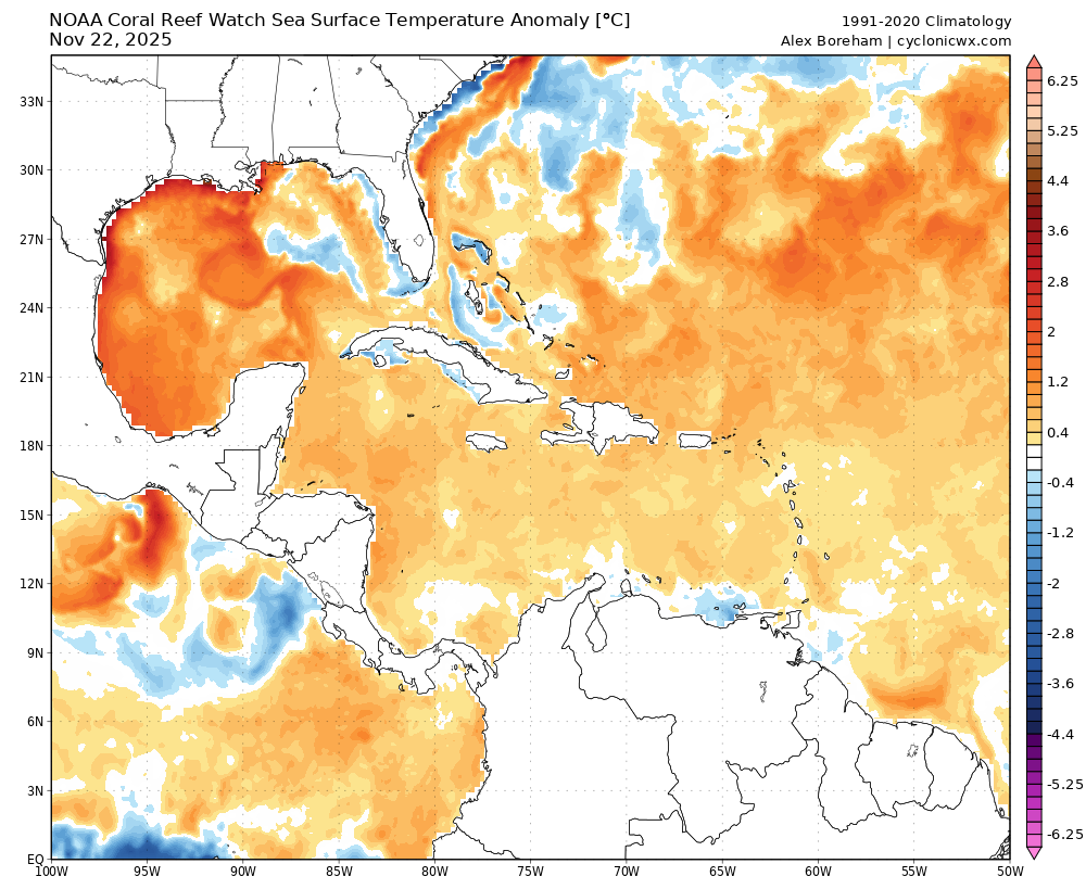
Cold air does look to follow this into the Central and Eastern U.S. eventually. But models continue to oscillate around on potential intensity and trajectory of the cold leaving a good deal of uncertainty. I’ve seen some pretty heady comparisons floating around with the early December cold, and those seem outright hyperbolic right now. Models cannot resolve things after this weekend in terms of how this is going to setup, so it would be wise to not assume anything about mid to late next week. Gulf of Mexico water temperatures are as warm as they’ve ever been this late in the year.
Gulf sea-surface temperatures are excessively warm for November. (Cyclonicwx.com)
Couple that with the seasonal resistance of a Southeast ridge that will likely be aided by these warm waters, as well as a distinct lack of snowpack over the Central Plains, and you can bet any cold air mass will modify a lot by the time it gets across the country.
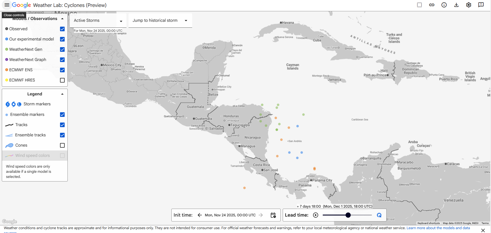
Speaking of warm water, some models are trying to spin up a tropical system in the southwest Caribbean next week. This is unlikely to happen, but the chances are better than just writing off the GFS operational model as totally out to lunch. Seasonally, there’s a metric ton of wind shear around, which likely severely caps any storm system that tries to develop. However, a minority of ensemble members from Google Deep Mind’s suite does show this possibility.
A small handful of various members of Google Deep Mind’s ensemble, along with a few other model members do suggest a small risk of a tropical system developing in the southwest Caribbean next week. (Google Weather Lab)
If something were to develop, expect it to be weak and sloppy like the Thanksgiving dinner guest you were on the fence about inviting that has no decorum.
Newsy bits
Closing out today with some newsy bits from the various articles I’ve been opening in my tabs.
Texas: I want to start with this piece by Alan Gerard from last week that takes another look at the flooding in Texas. There’s a lot to unpack here so I suggest you read the piece yourself. So many issues are involved with this, and so much remains left to be discussed. Alan does a good job taking stock of things from ground zero, as he had a chance to visit Kerrville recently. Worth your time. (Balanced Weather)
Philippines: One issue we see time and time again around the world is corruption rearing its head when it comes to government projects. We know this is a problem at times in the U.S. And in some ways, I worry we’ve become apathetic to things. Well, in the Philippines, they’ve had enough. A recent protest in Manila attracted an estimated 650,000 people, as billions of dollars in flood mitigation funds have apparently ended up lining the pockets of company owners, government officials, and parliament members. This is a huge issue, and the group organizing it is incredibly influential in that country’s politics. Stay tuned. (The Guardian, Al Jazeera)
Southern California: After last year, the specter of a bad fire season in California certainly had people nervous. Fortunately, at least in central and southern California, the current fire season is likely over. (LAist)
Arapahoe Basin: Ever wondered how ski resorts “make” snow? Here’s an inside look at how it’s done in Arapahoe Basin. (Summit Daily)
Athens County, Ohio: Athens County, Ohio is working on a thorough project to map flooding patterns in the county thanks to a recent grant. The goal is to take the knowledge gained from the mapping to recommend and apply nature-based flooding solutions to help mitigate future flooding in the region. (The Ohio Newsroom)
New York City: A well put together piece here describes some of the challenges and possible solutions for New York City in a world of higher tides, increasing rainfall, and increasing storm surge risk. (New York Times) A $218 million project in Brooklyn, specifically Red Hook may fall short of what is needed to help reduce flooding in that neighborhood. (NY Amsterdam News) Meanwhile, in Queens, a community impacted by Sandy feels neglected and forgotten. (The Guardian)
In brief: Stormy weather will bring some risk of flooding to Texas and perhaps Oklahoma over the next 5 days, followed by another storm system and cooler weather in the Eastern U.S. next week, just in time for Thanksgiving. Wednesday’s travel weather doesn’t look horrendous right now, but there are a couple things to watch. Plus, some links on newsier bits going on.
It’s Wednesday, November 19th, and I just wanted to check in with our audience! I am working on a more robust piece in the background on the Colorado River, a topic that is critically important beyond just the Southwest. This has ramifications nationally. A lot is going on there right now, and I’m trying to throw together a simple explainer piece for you all to understand it, as well as dump a list of books and blogs that I’ve found useful (or need to read more about) regarding this issue. Look for that soon.
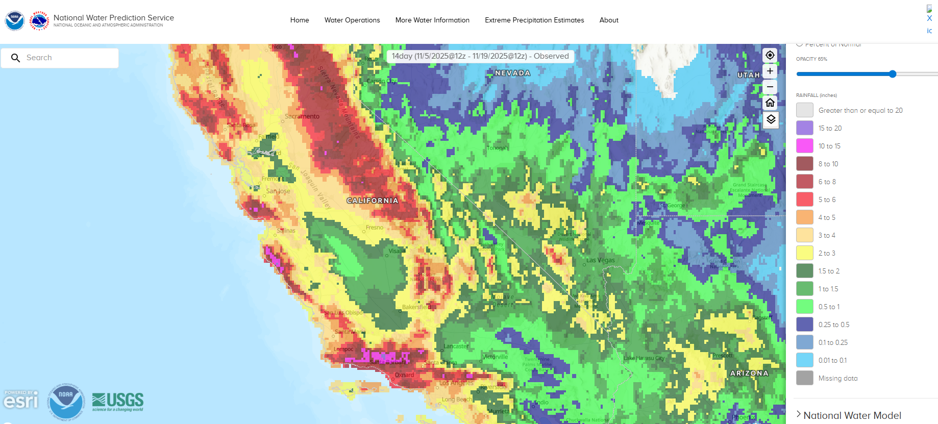
In the meantime, it’s been quiet in the Eastern U.S., while busy in the West with flash flooding in California, and flood watches currently posted in Arizona.
Estimated rainfall totals for the 2 weeks ending on the morning of November 19th, showing as much as 10 to 15 inches or more of rainfall in parts of California. (NOAA)
Parts of SoCal have been drenched with the mountains north of LA seeing anywhere from 5 to 15 inches of water over the last couple weeks. California needs the water, of course, but these storms have been fairly warm, so snowpack is not a real serious consideration yet, but in general, the highest peaks are now running above average in California, Arizona, and southern Utah.
In the East, it’s warm weather that we’re talking about. Numerous record highs will be threatened today and tomorrow across the Southeast and parts of Texas. While the pace of record warmth should ease up this weekend, generally above normal temperatures look to continue into the first part of Thanksgiving week before a cooldown in time for the holiday.
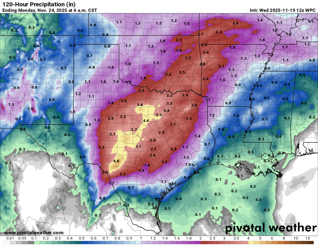
Rain totals forecast over the next 5 days look pretty substantial in interior Texas and southeast Oklahoma. (Pivotal Weather)
However, a series of disturbances in the Southern Plains will create a bit of a flooding threat, particularly in Texas. Rain totals of 2-5 inches are possible, if not likely from parts of the Rio Grande Valley through Hill Country into the DFW Metro. At this time, the risk of excessive, severe flash flooding looks low. But every so often, you can get a random band of storms in a situation like this capable of dumping 6 to 10 inches of rain on someone. Hence, flood watches are posted for Hill Country.
Flood Watches from parts of the Rio Grande into Austin, San Antonio, and Hill Country. (Pivotal Weather)
A second storm system will cross the state this weekend and next week bringing additional rain Monday and Tuesday before quieter weather.
Thanksgiving weather
It’s a bit early to get too specific regarding Thanksgiving, but we can begin to make some assumptions. First, for the big travel day on Wednesday, it looks relatively quiet in Texas and the Southwest. An incoming storm system may be possible in the Northwest. We can look at probabilities of 0.01″ of liquid as a rough barometer for where weather will occur. It seems plausible that thunderstorms could impact travel through Atlanta or Florida. Winds could impact flights in Chicago and Minneapolis. And a storm system could bring some precipitation to the Northeast and/or Midwest, depending on exact timing. It does not appear that holiday travel looks severely disrupted at this time, but you may still want to watch the forecast.
Probability of 0.01″ or more of rainfall next Wednesday. (Pivotal Weather)
The environment could become favorable for some lake effect snow later Wednesday or Thursday in the Great Lakes. Temperature anomalies for Thanksgiving Day don’t look overly impressive, but some colder air will give it the autumn chill that often defines late November from the Plains and Texas into the Midwest and parts of the East. The West looks mild.
Thanksgiving Day temperature anomalies show colder than normal over much of the Eastern U.S. (Pivotal Weather)
For those of you hearing chatter about stratospheric warming and the polar vortex breaking down and other such things, this is not that. Impacts from that stratospheric warming event (if they are felt at all) would occur more into December. It’s important to keep in mind that not all stratospheric warming events are equal. Some lead to cold. Others have minimal impact. This is a branch of the science we’re gradually learning more about but are not quite experts in just yet.
Newsy bits
FEMA: The head of FEMA stepped down this week. David Richardson, who has headed the agency for the last 6 months or so was criticized for not being reachable for a full 24 hours after the July 4th floods in Texas, a pretty inexcusable moment to go MIA. Richardson, with no EM experience, admitted he thought his job was to shut down the agency, when in reality (as we’ve seen many times when folks get put in these positions), he sees the need for the agency. FEMA has issues and needs reform at scale. I trust folks like Colleen Hagerty and Samantha Montano on covering these issues. But the current administration’s desire to eliminate it entirely and push everything onto states indicates a fundamental misunderstanding of disaster response and an agency that is already greatly misunderstood by politicians and the public alike. FEMA serves a vital function in a nation that is frequently impacted by disasters.
FEMA II: Of course, who is next is the question. There is some chatter about the administration’s desire to get the head of the Texas Division of Emergency Management, Nim Kidd to be the head of FEMA. Kidd has said he won’t leave Texas. So could the administration bring FEMA to him? I will say that when you have a strong candidate for a position, it is wise to make concessions, however, moving the entire agency for one individual seems a bit much. Anyway, grab the popcorn over the next few weeks.
Western Alaska: The village of Quinhagak in Alaska lost about 60 feet of shoreline from the remnants of Typhoon Halong in October. Concerns about environmental risk were being investigated, but it also disrupted the Nunalleq archaeological site, a significant pre-contact Yup’ik site there, scattering artifacts across the beach. Efforts were undertaken to save as much of it as possible. (Alaska Public Media) Here is a mid-November update on the rebuilding efforts underway. (Alaska Public Media) How local public media was a lifeline for rural, isolated communities in Alaska during Halong. And how it’s now being dismantled due to Trump Administration budget cuts. (Alaska Public Media)
Iceland: Mosquitoes have been found in the wild Iceland for the first time in recorded history. Whether it is related to climate change or just a hitchhiker that arrived as Icelandic tourism continues to thrive, no one knows. But if a population does become established there, it obviously would not be good. Bugs like mosquitoes can survive cold though, so we’ll see if this is a blip or a trend. (New York Times)
Grand Junction, Colorado: The Aedes aegypti mosquito is establishing itself in parts of the West where it was never deemed possible previously. The culprit? Climate change. As nighttimes warm, the mosquitos have fewer opportunities to be wiped out due to harsh cold that periodically has arrived in the interior West. Grand Junction saw the fewest nights below freezing on record last winter, and it’s allowing these creatures an opportunity to survive in new places. (Inside Climate News)
Louisiana: Could floating homes help solve issues of housing and flooding risk in places like New Orleans? The idea that a home could float as water rises instead of the structure flooding is an intriguing one. Can it be done sustainably and cost-effectively? The concept has worked in some places with less engineered structures, so the question becomes whether existing, bulkier homes could be retrofitted in a way. (The Current, Lafayette, LA)
Panama Canal: Droughts, such as the one experienced in 2023 could become more frequent in the future with climate change, new research shows. At a previous job, I dealt with questions about this drought involving Gatun Lake, the primary source of water to help fill the locks in the canal (as well as a major drinking water source). While the lake often fluctuates due to El Niño and La Niña precipitation patterns in the Pacific, more frequent droughts or at least more frequent extremes is a common concern across the globe as the planet warms. (AGU)