In brief: Invest 91L in the Atlantic has seen waning model support for growth in the last 24 hours, but it remains a system to monitor for folks in the Caribbean islands. Meanwhile, Hurricane Kiko in the Pacific looks likely to impact Hawaii next week, though specific details are uncertain at this time.
Atlantic tropical wave – Invest 91L
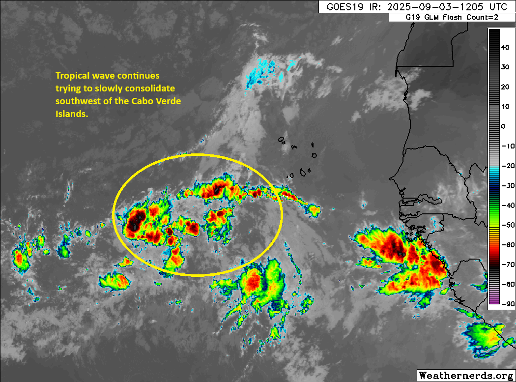
Yesterday, the wave in the Atlantic got classified as Invest 91L. Since then, it has proceeded to do absolutely nothing.
There are about 3 other things more interesting looking than Invest 91L on the satellite image above. (Weathernerds.org)
There were some signs of circulation overnight, but the thunderstorms remain fairly displaced and sporadic. Basically, this thing is struggling. And in an interesting twist, the AI models have now completely lost 91L. Google’s Deep Mind ensemble is showing close to nothing at all. Support and enthusiasm from both the Euro and the Euro ensemble have faded as well. Odds remain 90 percent that something will develop over the next 5 to 7 days, but if I’m being honest, the data is struggling to support this a bit at the moment.
Given that we would still have a good 5 or 6 days for the system to get to the islands, we’ve still got time to watch and see. Maybe this will finally come around tonight or tomorrow and head for development. Who’s to say? Interests in the Lesser Antilles should continue to watch the progress of this to be safe. But for now, we’ve got a lot of speculation and few specifics to work off of. We’ll continue watching this through the weekend.
Pacific Hurricane Kiko
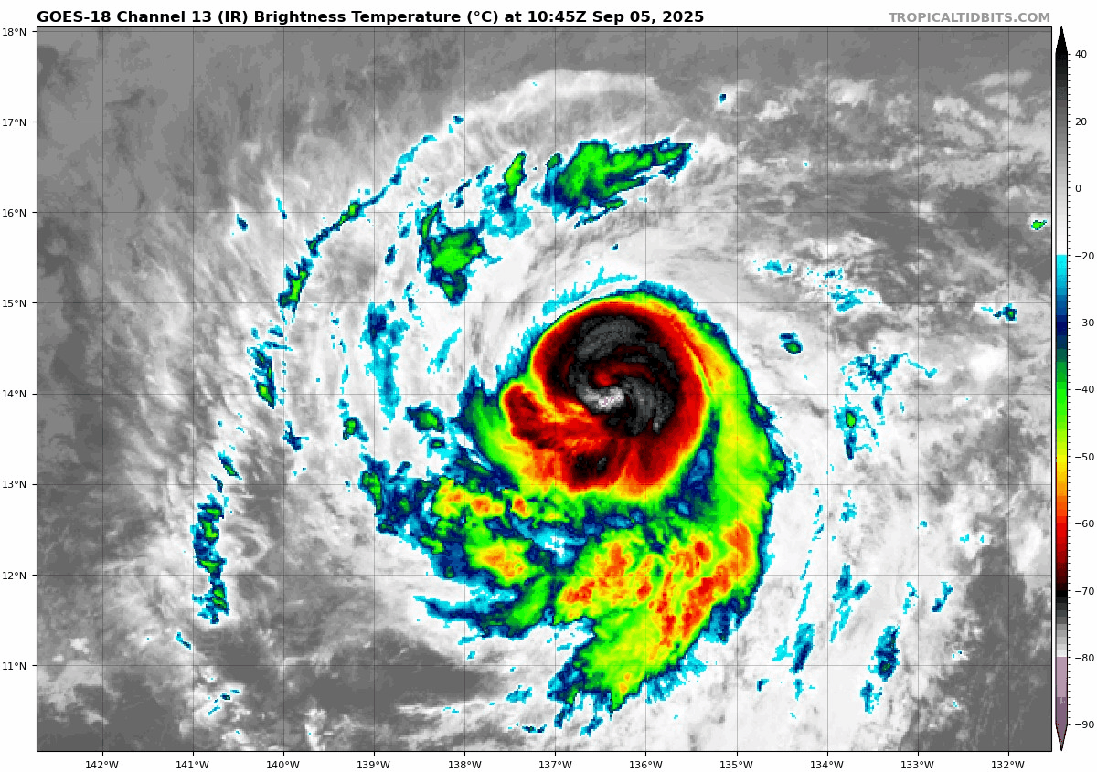
Kiko remains a major Category 3 hurricane this morning. It continues to track off to the west but will shift more to the west northwest today. The environment around Kiko remains generally favorable for another 18 to 24 hours, so it’s possible that Kiko could come out of an eyewall replacement cycle here and re-intensify some.
Hurricane Kiko has lost some of its luster, but it remains a significant hurricane. (Tropical Tidbits)
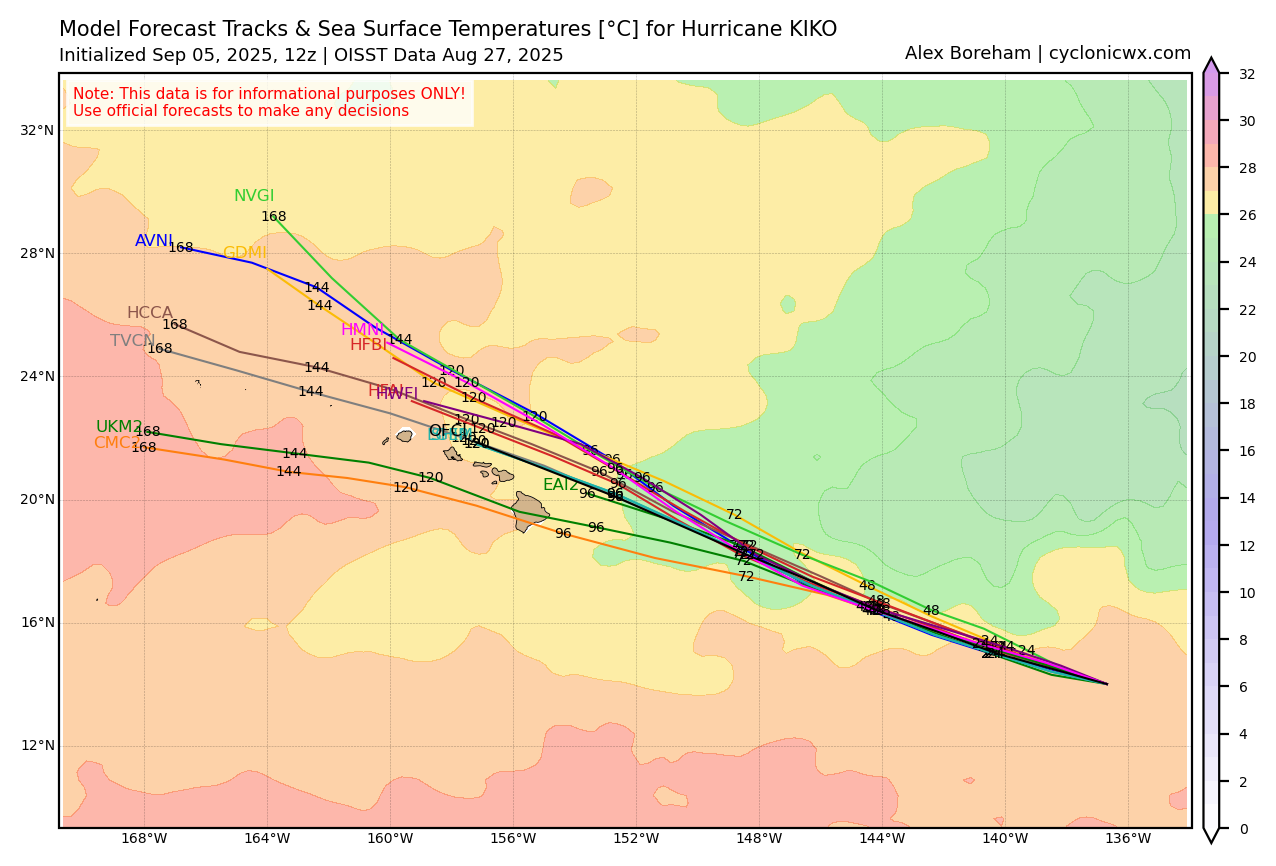
From there, Kiko will hit some cooler water, which should allow for weakening. By the time Kiko approaches Hawaii, it is expected to be a tropical storm.
Kiko’s model spread and sea-surface temperatures it will be traversing. (Cyclonicwx.com)
As of now, modeling generally wants to keep Kiko north of Hawaii, which would probably mean that the strongest part of the storm misses north as well. That said, there remain a couple outliers that do drag it southward a bit. The general consensus though appears to be very near the OFCL (NHC forecast) above. We have about 5 days to watch before it arrives there, but we know that there should be some rain and wind impacts likely based on the current forecast, particularly for the northwestern islands. We will continue to monitor this through the weekend as well to see how the specific impacts in Hawaii begin to shape up.
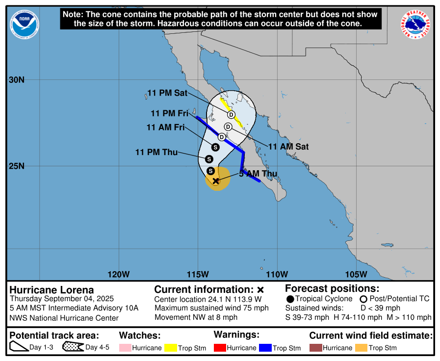
We’ll give it a pause there for today. Lorena has dissipated into a post-tropical system and will actually turn left back out to sea. Though that system’s impacts in the Southwest look to remain limited, there are flash flood watches today for burn scare areas in New Mexico, including Ruidoso, so just something to be aware of outside of the tropics but still somewhat related.
In brief: Three interesting systems dot the landscape from the central Atlantic to the central Pacific. The Atlantic wave continues to see slowly building development odds, but it’s terribly slow moving right now. In the Pacific, Lenora will bring rain chances to the Sonoran Desert, while Kiko is ultimately looking like a storm to watch for Hawaii.
Atlantic tropical wave
Well, the tropical wave in the Atlantic has still failed to classify as an invest as of this writing. Odds of development are up to 80 percent today. And if you look at satellite, it appears that the wave is rather compact, or at least the thunderstorms associated with it are.
A fairly compact area of thunderstorms has blown up overnight around the tropical wave moving west of the Cabo Verde Islands. (Weathernerds.org)
Whatever happens here, my guess is that this is not going to be a large system (in size) initially. The other story with this wave is how slow it’s moving. We’ve seen some systems book it across the Atlantic in recent years, but this wave is the Sunday driver of disturbances, really taking its time to come west. We’ll continue to say that this area should be watched for the Caribbean islands, but the fact of the matter is that most model guidance doesn’t bring it near that area until the earliest next Tuesday, if not Wednesday.
From a development perspective, the slow movement of the wave can be both good or bad. It gives it more opportunity to perhaps be impacted by external things like dry air or shear. On the other hand, it also gives it a chance to perhaps insulate itself from those impacts for a time, particularly by being such a compact system. Smaller systems can also ramp up fairly quickly, but they can also very quickly weaken if impacted by hostile conditions.
So, we still have a lot of time to watch this, but it does seem like the islands, including Puerto Rico will want to continue to monitor the progress of this system as it crawls west. There are still a number of model solutions that turn this to the northwest and away from the islands, so it’s not a guarantee that it even gets there. But we do know that there is at least potential for development with it that could bring impacts to the islands next week.
Beyond the Caribbean, the overall weather pattern next week has been trending toward a slightly stronger trough along the East Coast of the U.S.
The last several European ensemble model runs showing a sharpening trough (more blue) on the East Coast. (Tropical Tidbits)
What does this mean for the future of a possible tropical system? Well, for one it would likely begin to gain latitude at some point near or in the northeast Caribbean. It could turn before that point, but this overall setup favors something eventually turning northwest. This is not until next weekend though, a good 8 to 9 days away. So, yes, keep an eye on this if you live from Florida to the Carolinas or in Bermuda, but we have a long, long way to go.
Beyond this, another tropical wave may emerge off Africa next week that’s worth watching for the week of the 15th, but that’s way out there in time.
Pacific Hurricane Lorena
We talked the other day about Lorena possibly becoming a tropical storm or borderline hurricane. Indeed, Lorena did just that, becoming a stronger category 1 storm. It is now undergoing weakening as it moves into cooler waters near Baja, and it will likely come ashore later tomorrow as a disintegrated, post-tropical depression.
Look for Lorena to come ashore late tomorrow night as a post-tropical system, likely depression strength in central Baja. (NOAA NHC)
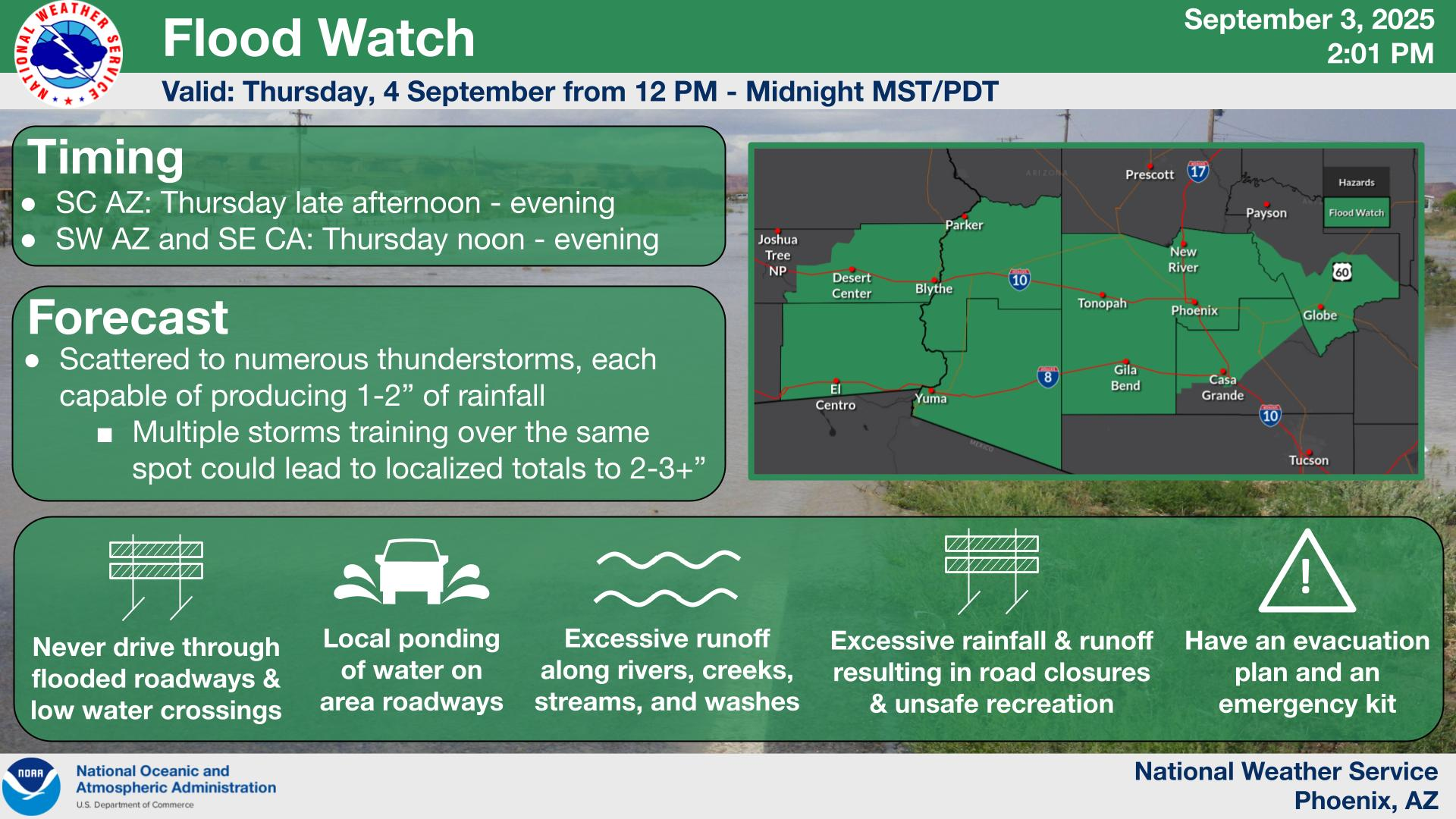
Where Lorena may leave its mark is via rainfall. Flood Watches are posted across the Sonoran Desert from southeast California through Phoenix into Tucson. Interestingly, a combination of factors, including the slow movement of Lorena, cloud cover overspreading the desert, and some reduced instability from storms overnight may act to limit how much in the way of thunderstorms can develop today across Arizona. There are always uncertainties, but it may be that the desert sees less activity today than perhaps initially thought.
Despite the question marks and uncertainty, there remains a flood watch from southeast California through Phoenix and Tucson today. (NWS Phoenix)
The higher storm risks may end up being north of the major cities of southern Arizona and north of I-10. While rain rates and totals should cause some reports of flash flooding today or tonight, only very isolated areas seem to be at risk for something more significant. A few higher end totals of 2 to 4 inches may occur in spots, but those would be the exceptions rather than the rule.
Some of the higher end rain risks pivot into New Mexico and Texas this weekend.
Pacific Hurricane Kiko
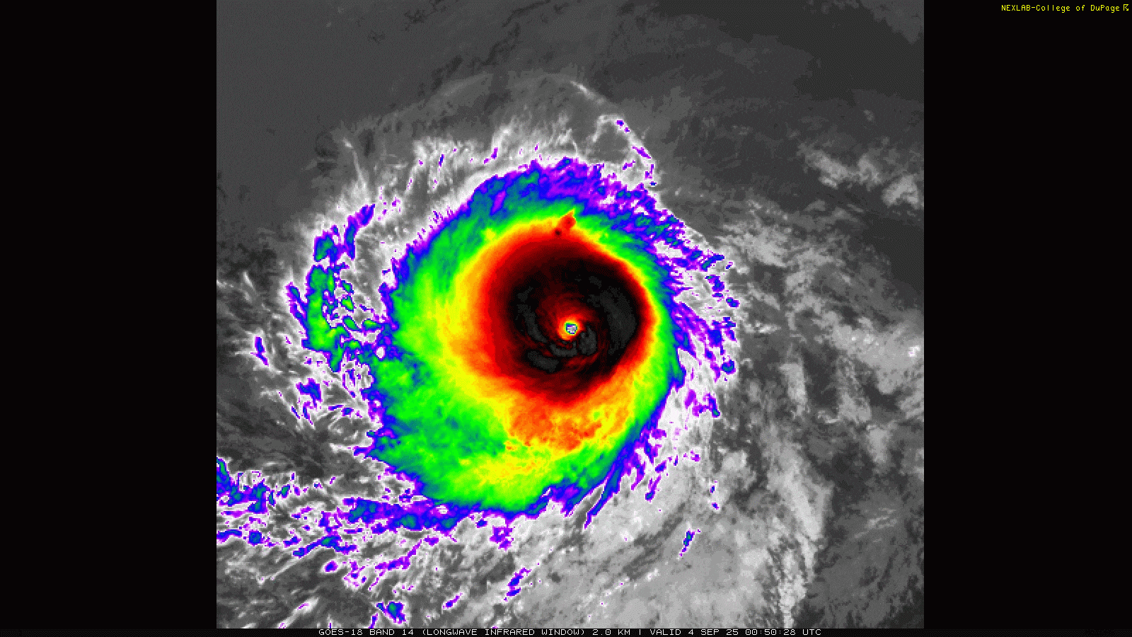
In the middle of the open Pacific, Kiko has blown up into a monster hurricane the last couple days, achieving category 4 intensity, with winds currently still at 145 mph. However, it seems as though Kiko is undergoing an eyewall replacement cycle, as it has lost a little of its luster from 12 hours ago. You can see on the satellite imagery taken 12 hours apart how Kiko’s structure, while still extremely healthy, has degraded a bit.
Hurricane Kiko between last night and this morning. (College of DuPage)
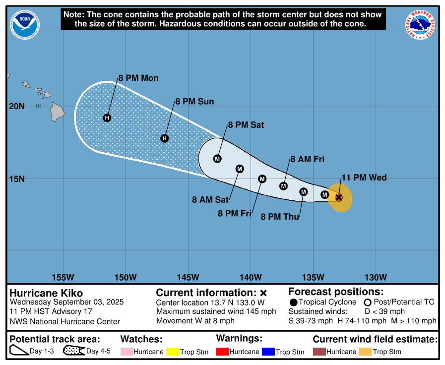
Kiko marches onto the west, not currently threatening land. However, Kiko will be an intriguing item to watch as it relates to Hawaii.
Kiko will track west and west northwest over the coming days, approaching Hawaii as a dramatically weaker storm next week. (NOAA NHC)
You can see above how by Monday, Kiko is a few hundred miles west of the Hawaiian Islands. Kiko will dramatically weaken from where it is now, but it seems as though it may potentially maintain some degree of intensity.
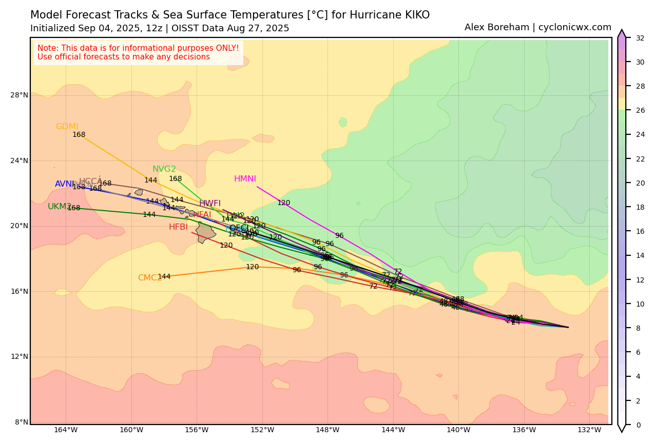
Tropical models and sea-surface temperatures on the path of Kiko (Cyclonicwx.com)
Notice how Kiko will likely traverse water temperatures below 26°C over the next few days. For hurricanes, generally we want to see above those levels for intensification. So we should slowly see Kiko weaken. Now, what is somewhat interesting is how water temperatures do increase again around Hawaii. We’re at least 5 to 6 days out from any possible impacts in Hawaii, but this is a storm worth watching for the islands, both from a wind and rain perspective. At the least, this may be a Douglas (2020) or Linda (2021) type impact risk for the islands. Beyond that, it’s a little too early to say. But folks in Hawaii should be monitoring the progress of Kiko for next week.
In brief: The tropical wave in the eastern Atlantic continues to slowly consolidate. Development odds remain elevated over the next week, but there’s a pretty significant difference between most ensemble guidance and operational guidance versus yesterday that raises some questions. Worth continuing to monitor in the islands.
East Atlantic tropical wave
Another day, another update on the tropical wave we’ve been discussing since last week that’s still at least a couple days from even developing.
The tropical wave looks a little more consolidated compared to 24 hours ago, but it’s still not even at Invest stage yet. (Weathernerds.org)
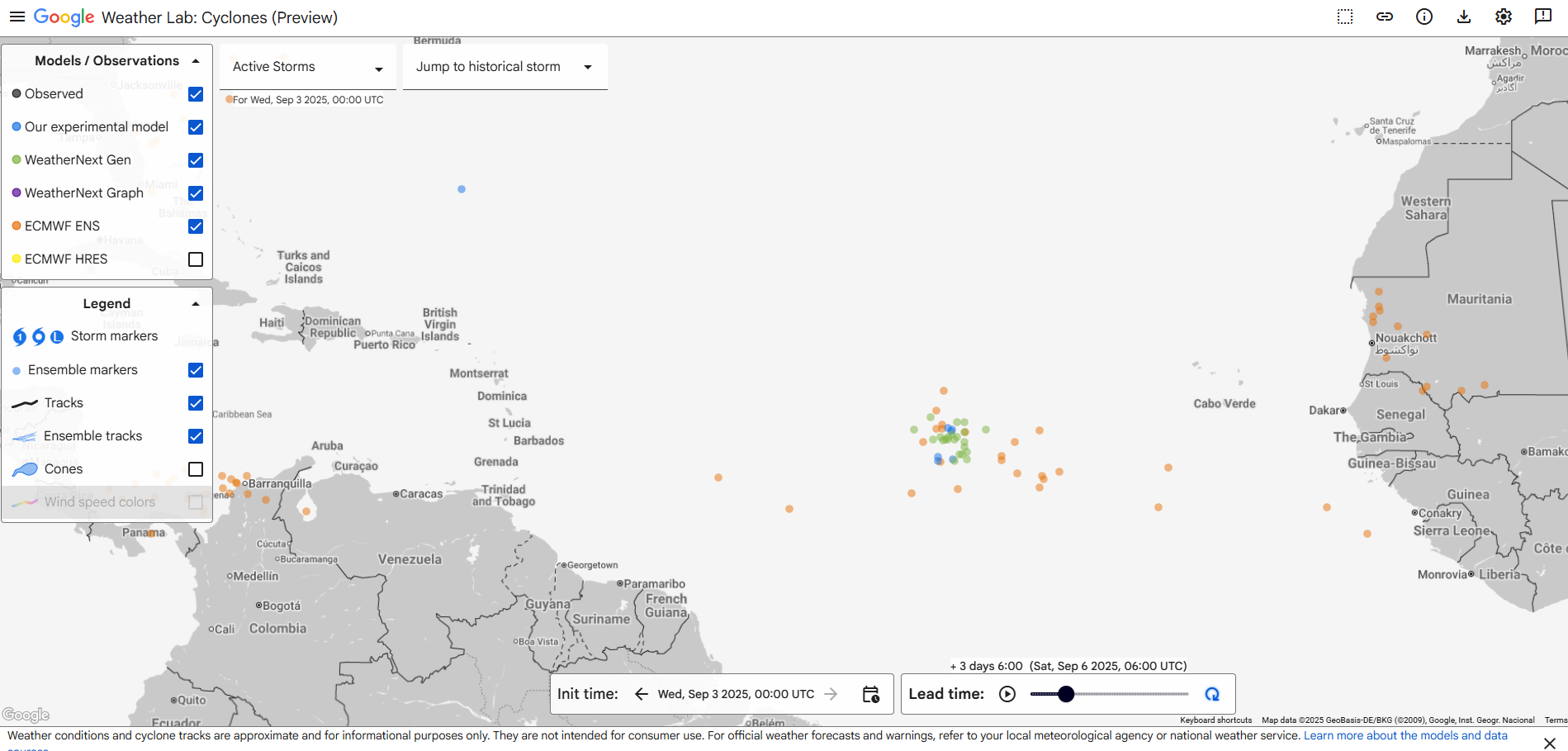
The wave looks marginally better than it did 24 hours ago; it’s a little more consolidated at least. But it remains far from really *doing* anything yet. I imagine it will approach Invest level by tonight or tomorrow, as models show further consolidation of the disturbance up around 10,000 feet altitude. All that said, my impression of the ensemble modeling this morning is that support has actually dropped a bit with respect to development. Fewer European ensemble members are developing the system, fewer of the Google Deep Mind AI ensemble members are doing so also. In other words, ensemble model support for this, broadly, seems to be stagnating. The NHC odds remain at 70 percent, and that seems fair for now.
About 30 to 40 percent fewer ensemble members than a day ago have this wave developing by Friday night in the central Atlantic. (Google Weather Lab)
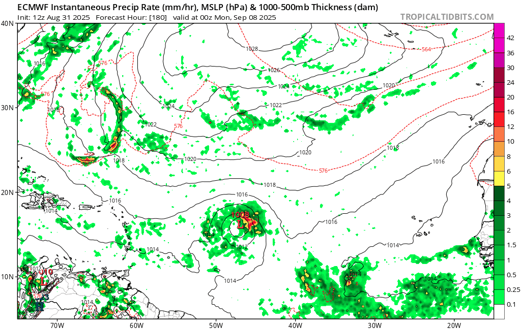
I emphasize the ensemble modeling above. Interestingly, if you look at last night’s European operational model, it actually does show it developing and developing aggressively too. Other operational models do too, the GFS less so, the ICON more so. We often preach not to pay much mind to the operational model guidance, and in this case it would also be wise to be skeptical. If you look at the current 5-day out forecast from the European operational model over the last several days, you can see how the model has waxed and waned.
The last several days of European model runs show varying solutions, placements, and intensities of the tropical wave east of the islands at day 5 (Sunday night). (Tropical Tidbits)
There’s a chance here that this is a smaller storm (the Euro solution in particular reminds me of what we’d call a “microcane,” or an especially small hurricane) and the higher resolution operational models are going to be more apt to “see” intensification happening rather than the AI ensembles. In my experience, storms like that have a window to do what the operational modeling says they’ll do. And if they miss the window, you can forget development. I really think this one is a tricky call. Kind of a fascinating case meteorologically too. We’ll know in a couple days whether this is a legitimate concern for the islands, but for now it makes sense to just check in each day for the latest.
Beyond the islands, it seems this gets picked up and absorbed by a trough off the East Coast. But it’s too early to speculate too much there. Right now, we just need to figure out whether this thing can even get off the ground.
Going to cut it a bit short today with a pretty full schedule today. But there isn’t much else of note in the tropics at least. More tomorrow!
In brief: While it’s too early to say anything with a lot of confidence regarding the disturbance in the Atlantic, we think it will slowly crawl west this week and perhaps approach the islands by early next week. We explain what we know. Plus, the Desert Southwest may get some beneficial rain courtesy of the latest Pacific tropical depression!
Tropical Atlantic disturbance
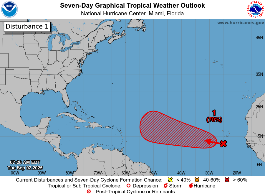
The odds continue to increase that the wave off Africa will develop over the coming days. The National Hurricane Center is up to 70 percent odds today for the next 7 days.
The development region over the next 7 days extends to just east of the islands. (NOAA NHC)
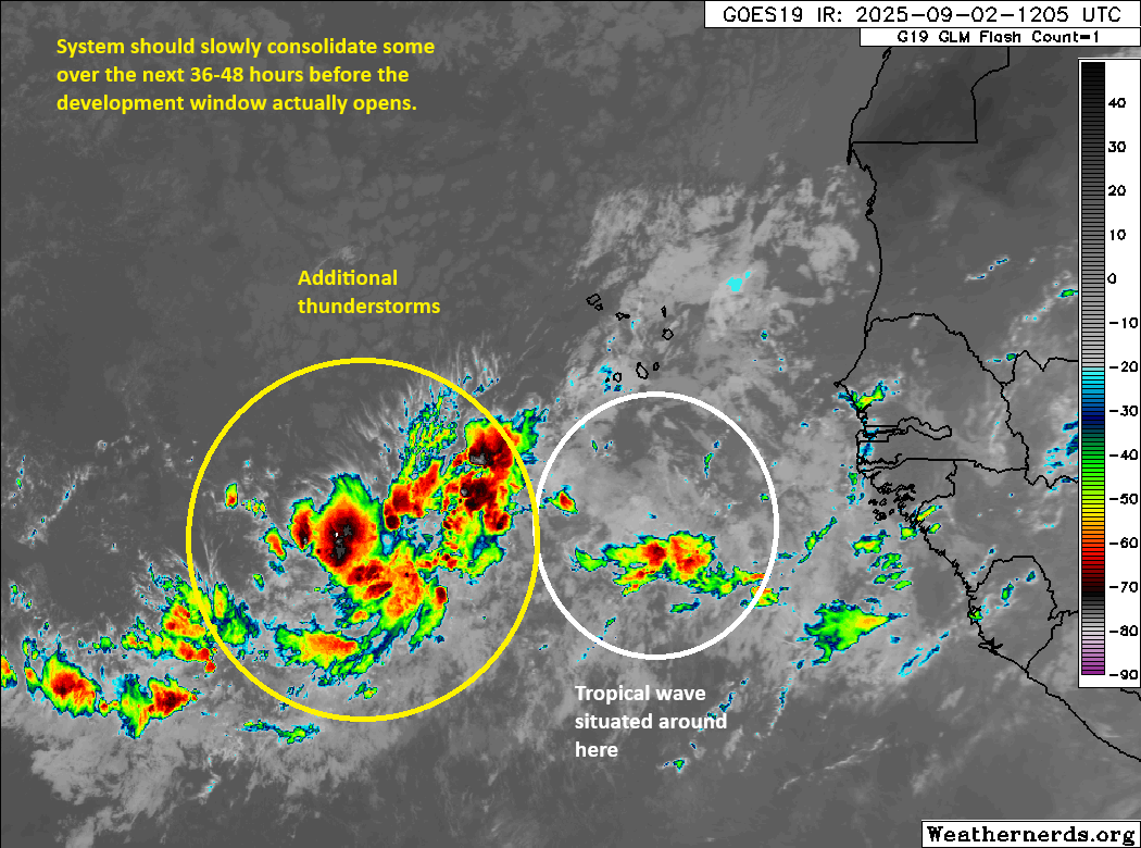
This system is still about 7 to 8 days away from making it to the islands if the models are to be believed. This one seems to be getting its act together at a much slower pace than feels usual. Whatever the case, thunderstorms are ongoing west of the tropical wave itself. Over the next 36 hours or so, expect the whole broad area to gradually consolidate into something a little more focused southwest of the Cabo Verde Islands.
While the tropical wave itself is located just south of the Cabo Verde Islands, most of the thunderstorms are west of the wave. It will take a good 36 to 48 hours to consolidate into something that can possibly develop. (Weathernerds.org)
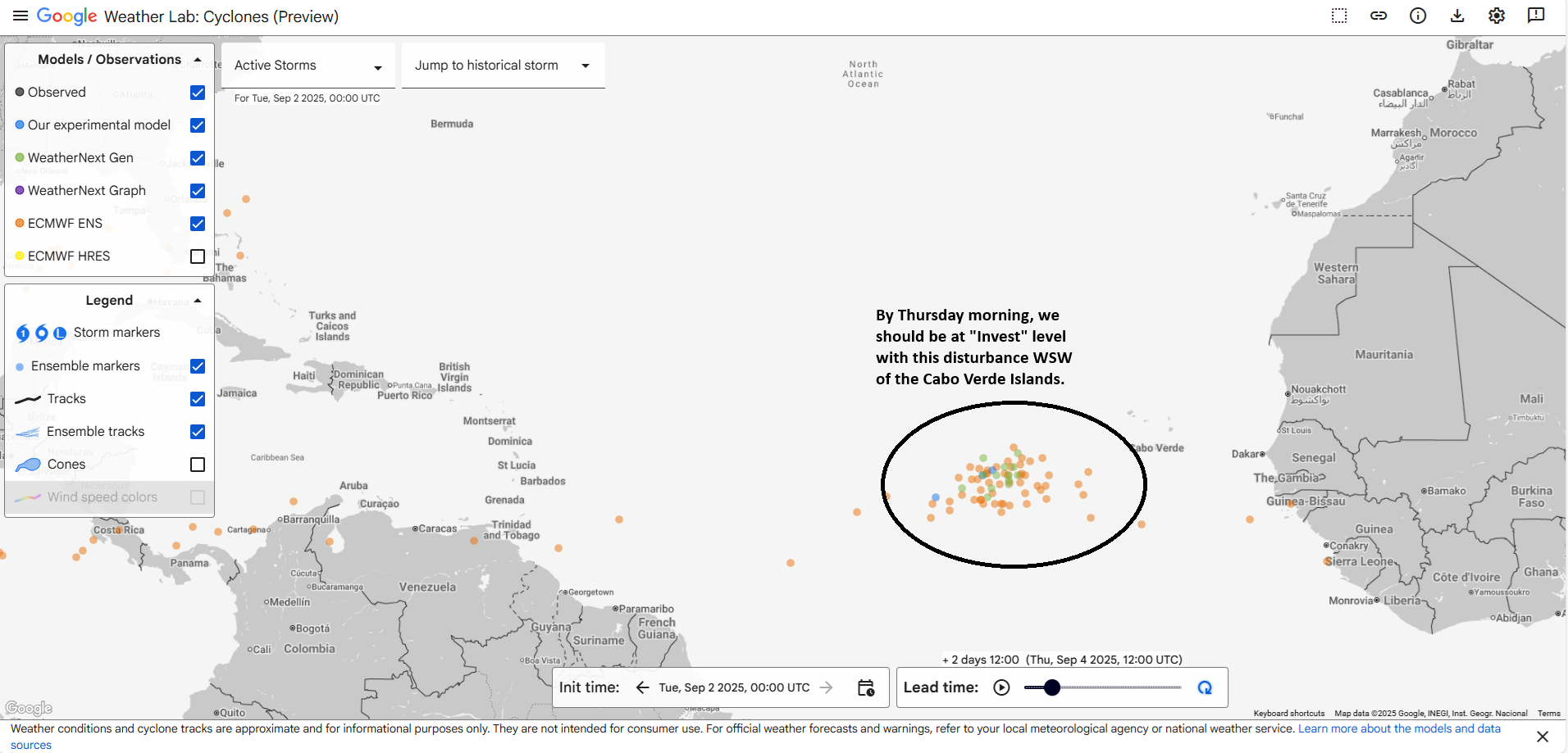
Given the current situation with thunderstorms well to the west of the wave itself, you can see that beyond “there may be a good chance of development,” much is uncertain right now. What we can say is that by Thursday morning, we should have some nascent organization ongoing, probably something like an Invest to the west-southwest of the Cabo Verde Islands.
Various Euro ensembles and AI models show some very nascent organization happening with decent agreement to the WSW of the Cabo Verde Islands by Thursday. (Google Weather Lab)
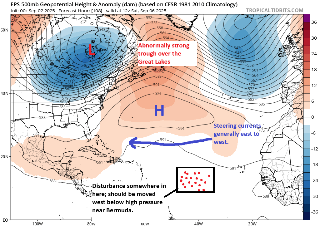
Where models can’t quite agree is at what longitude exactly this occurs. There’s a solid 6 to 7 degree spread in longitude for where this is as close as Thursday morning. This will obviously have ripple effects on whatever comes next. But rather than just throw up our hands, let’s talk about what should be happening as this comes west. Let’s assume by Saturday we have an organizing disturbance around 40 degrees longitude.
The overall setup on Saturday favors an east to west moving disturbance under Bermuda high pressure. (Tropical Tidbits)
This seems to suggest that the islands should probably keep an eye on this disturbance. Any organization is probably going to be sluggish here, as there are other hurdles this still has to encounter and overcome. But I think what we can say through the weekend is that a westward moving tropical disturbance may begin to slowly develop as it approaches the Caribbean islands.
Beyond that? There I will shrug. In theory, the high near Bermuda is expected to strengthen and shift just a tiny bit east. With a lingering trough over the East Coast, this should allow it to begin gaining latitude at some point early next week. But going out from there, I don’t want to speculate on what may or may not happen. At this point in time, it’s not a realistic threat to land, but it is worth monitoring through the week for the Caribbean islands. For the U.S., you can revisit this again in a couple days. We are a long, long way out still.
After this wave, I’m sure we’ll get another, but admittedly, the next 7 to 10 days look pretty mild across the Atlantic basin other than this one disturbance.
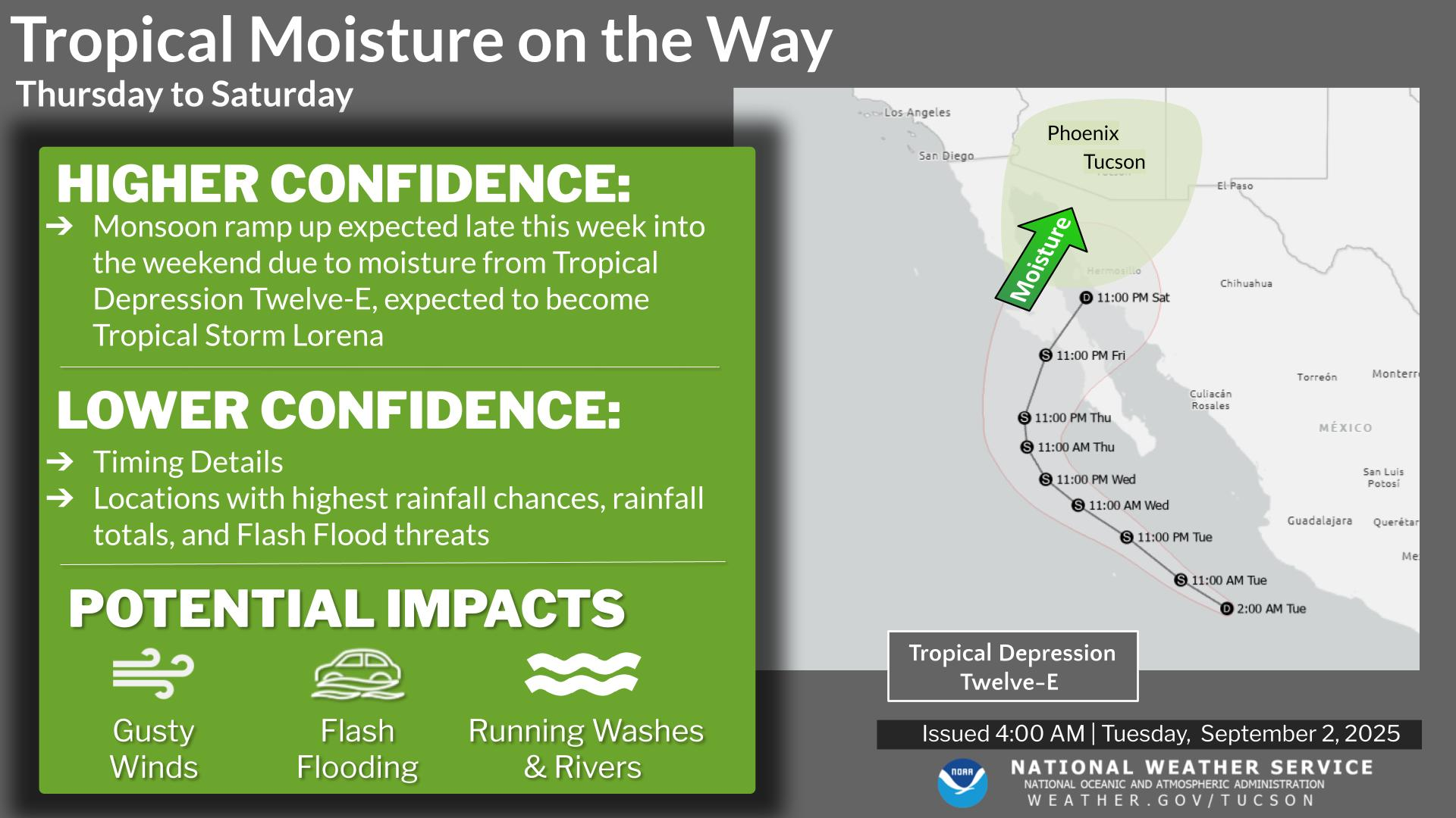
TD 12-E in the Pacific a rainfall maker for the Southwest?
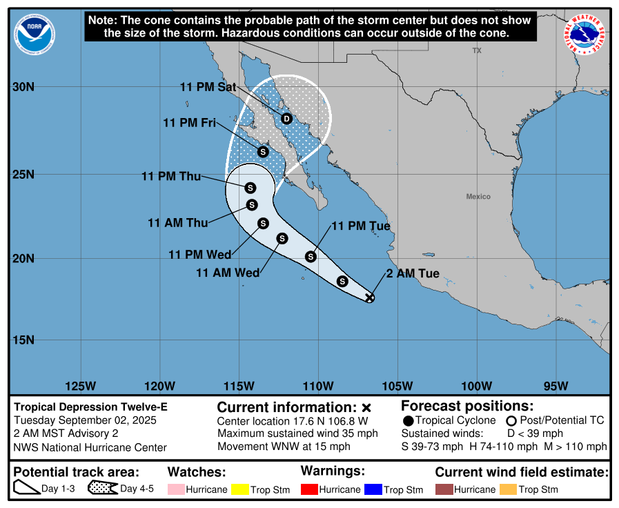
Shifting into the Pacific basin for a moment, Tropical Depression 12-E has formed, and it would appear that this will make it toward Baja by Friday, probably as a tropical storm.
TD 12-E in the Pacific is likely to make it to Baja by the weekend as at least a tropical storm. (NOAA NHC)
There is a chance that this system will push hurricane intensity. But 12-E (or what should be named Lorena) will probably be notable for its moisture. Additional moisture should pivot into the Southwest this week. This will allow for an uptick of (mostly) beneficial rains in the Southwest.
(NWS Tucson)
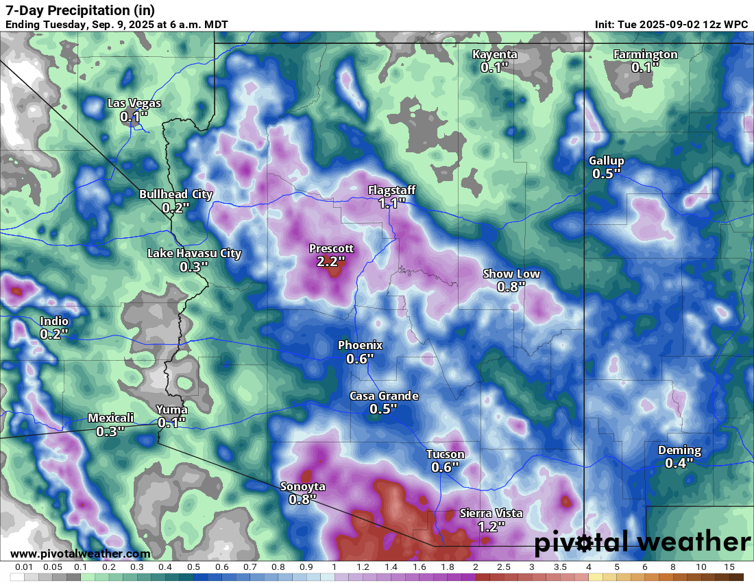
Details will still need to be sorted out, but this seems like a good setup for a tropical moisture plume to be stretched north toward Arizona and New Mexico. I would anticipate heavy rain chances, at least in scattered locations by the weekend. Indeed, the rainfall forecast for southern Arizona and even northern parts of the state is pretty lucrative over the next 7 days.
The initial 7-day rainfall forecast for Arizona and western New Mexico is pretty healthy. (Pivotal Weather)
Some of the rain near the border with Mexico does fall over the next few days. Anticipate some further adjustments in the overall rain forecast for Arizona and New Mexico as we get closer to the weekend.