In brief: Invest 93L is ashore and not a development risk, bringing more rain and flooding risk to Louisiana and the Gulf Coast. More non-tropical flooding concerns exist today in Virginia and tomorrow in Indiana. And an end of the month heat wave for the Plains, Midwest, and Southeast is looking more and more likely.
Invest 93L: RIP
Shout out to all the purveyors of doom on social media (including some professional meteorologists!) that just had to hype up Invest 93L into something it would never be. Development odds are down to zero percent this morning because the system is over Louisiana now. It’s dead, Jim.
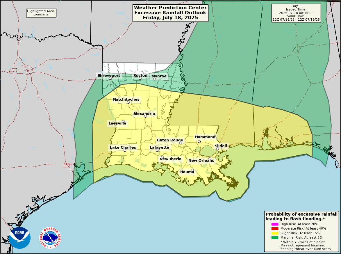
That said, it’s not exactly dead dead. It’s still producing rain, and it remains at least a slight flooding risk (2/4) for much of Louisiana, extreme East Texas, and parts of the Gulf Coast.
A slight risk for heavy rain and flooding exists from Beaumont, TX east across most of Louisiana to the Florida Panhandle today. (NOAA WPC)
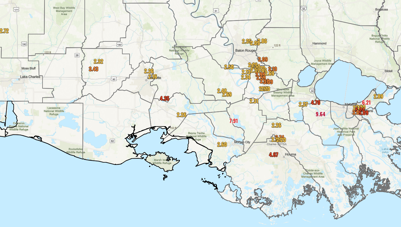
There have certainly been some locally impressive rainfall totals in Louisiana, including just shy of 10 inches in the last couple days in St. Charles Parish.
A sampling of 48-hour rainfall totals in Louisiana including nearly 8 inches just north of Morgan City, over 6 inches in New Orleans East, and nearly 10 inches in St. Charles Parish. (NOAA)
I have not seen any reports of major flooding, so that’s good. But let’s see how today unfolds. Some models are still a bit cheeky with rainfall totals in a few spots today, so never declare victory until the storm is officially over.
Rest of the tropics
It looks pretty quiet over the next few days. It is possible that we see something low-end and brief in the open Atlantic early next week, but there aren’t currently any land threats. It’s also possible that the remnants of 93L do a loop around the Southeast and re-emerge again in the Gulf later next week. I’d say that’s something to watch, but much like this week, proximity to land may hinder any development chances.
Flooding risk du jour
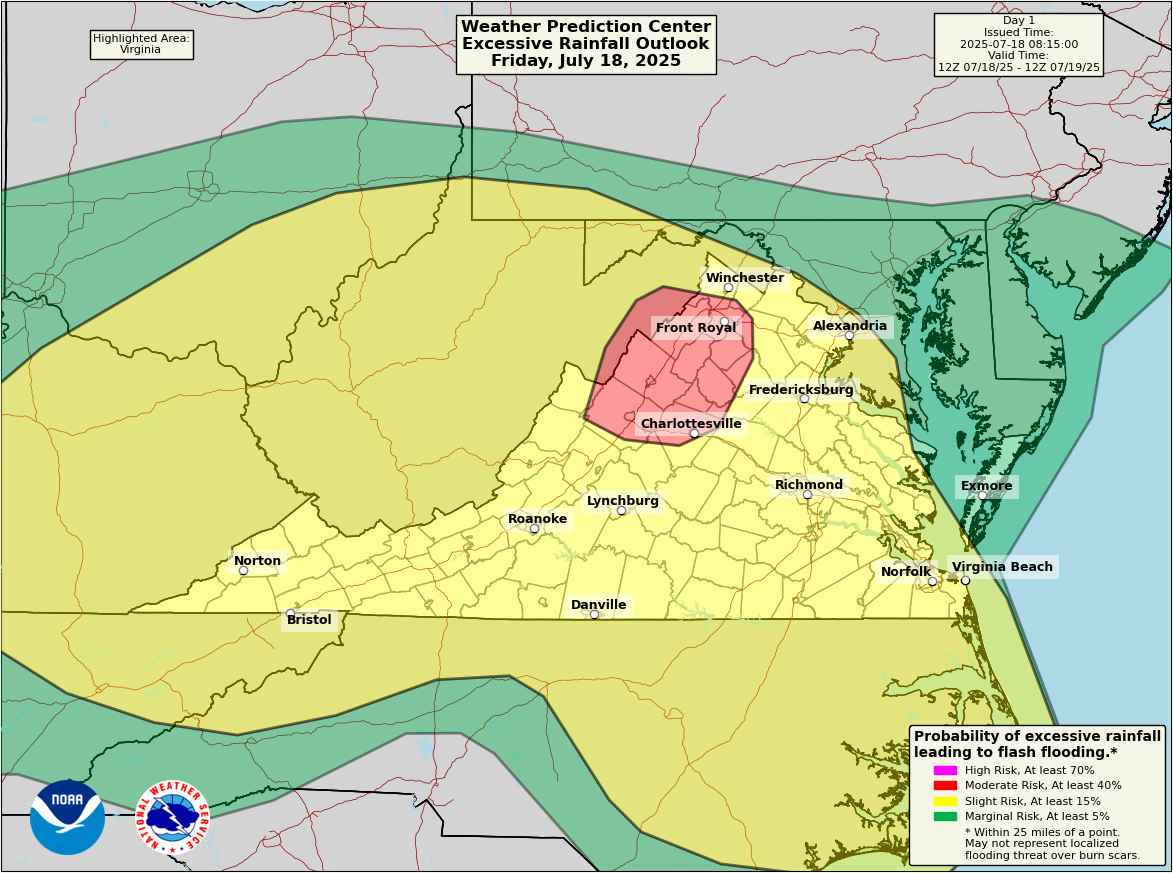
If you had northern Virginia on your Summer 2025 flooding Bingo card, congrats, and don’t forget the free space.
A moderate risk (3/4) is in place for the northern Shenandoah Valley in Virginia today for flooding. (NOAA WPC)
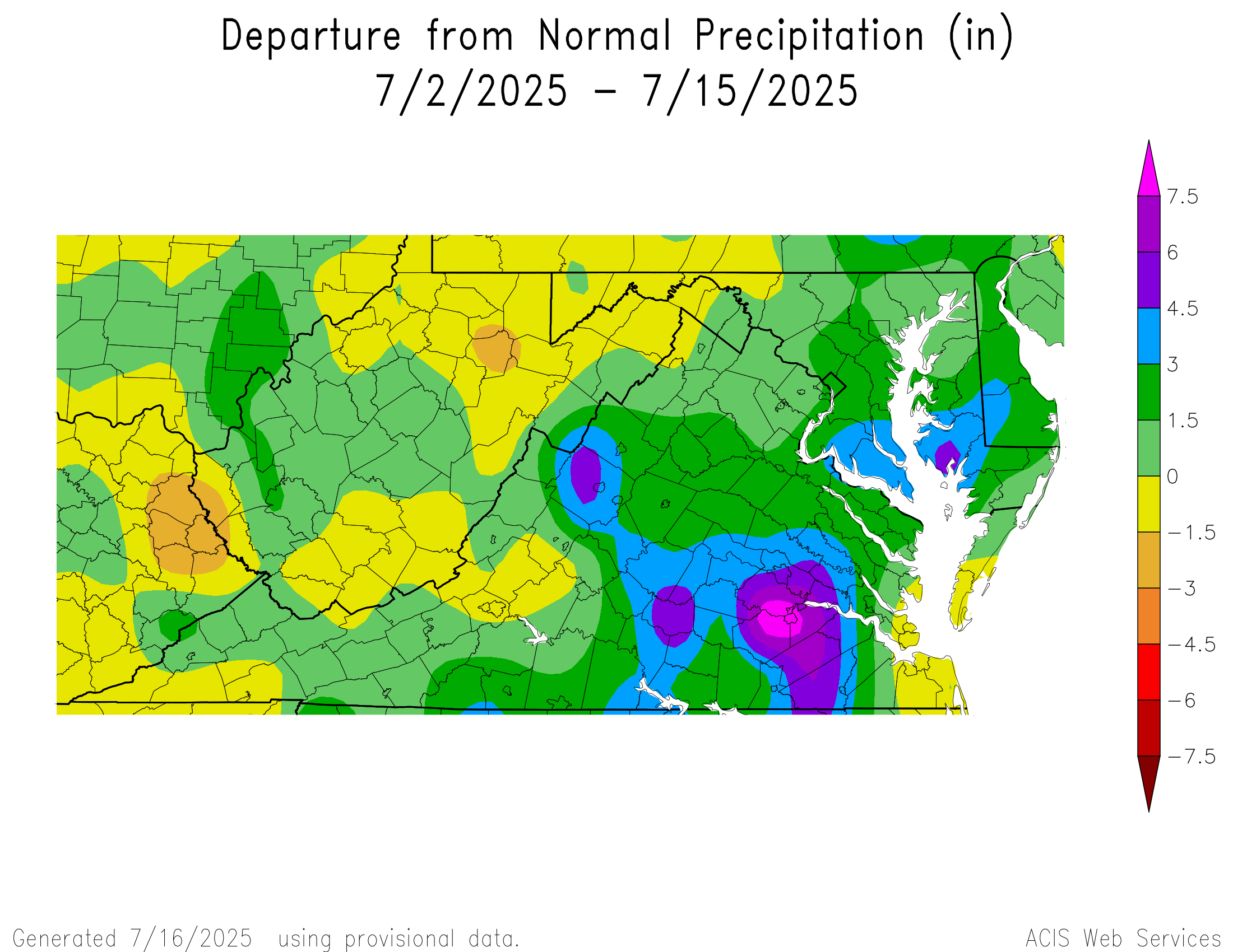
Parts of the northern Shenandoah Valley have seen 200 percent of normal rainfall so far this month, with some places seeing as much as 4 to 8 inches of rain since the start of the month. Heavy showers and storms are possible there later today, and this would be a definite area to watch for flooding today. A broad area of slight risk (2/4) surrounds that extending into parts of the Ohio Valley and south into Hampton Roads and the Outer Banks.
Flooding risk du jour Saturday
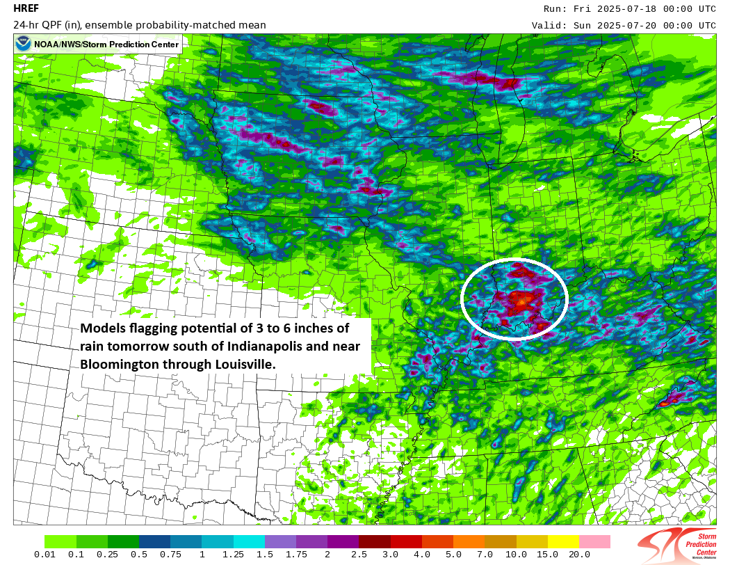
Tomorrow, I would watch Indiana closest. There is some modeling showing as much as 3 to 6 inches possible, mostly tomorrow in that area. Southern Indiana has seen anywhere from 4 to 8 inches of rain this month as well.
The SPC’s HREF model flagging some significant rain potential in southern Indiana on Saturday. (NOAA SPC)
The HREF model in particular is a little excited about potential heavy rain. The probability matched mean product above suggests that rain amounts of 3 to 6 inches will be possible tomorrow in the heaviest storms mainly south of I-70 in Indiana. I’d pay particularly close attention in the Bloomington through Louisville corridor on Saturday.
Additional rain may follow Sunday and Monday, and flooding risk remains in place there.
Heat wave update
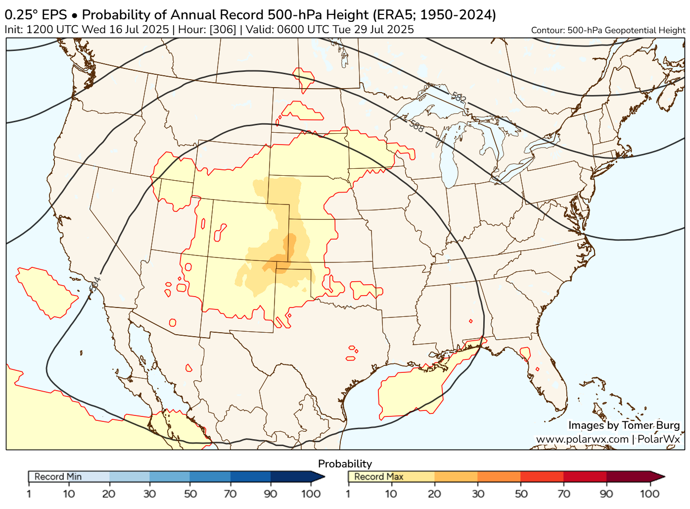
The European ensemble model continues to indicate a decent risk of a record strong ridge of high pressure in the upper atmosphere over the Plains in about 10 days or so.
The percentage of European ensemble members indicating a record strong ridge of high pressure is now up above 30 percent near New Mexico and the Texas and Oklahoma Panhandles. (Polarwx.com)
The Climate Prediction Center continues to indicate a risk of extreme heat starting around July 25th and continuing through the end of the month. There is also now some potential for drought to begin developing and expanding in parts of Kansas.
Odds continue to grow that a significant heat wave will impact the Plains, Midwest, and parts of the Southeast to close July. (NOAA CPC)
Overall, it appears the end of the month may be more about heat than flooding. But we will see.
In brief: Invest 93L is almost out of time as it transitions into exclusively a flooding concern for parts of Louisiana. The tropics may pick up some activity toward later July. And there are growing signs that the end of July may end on a very hot note over much of the country.
Invest 93L
In terms of development, Invest 93L is approaching the end of the road. It seems unlikely that it will get a name, and it probably won’t become a depression either. There’s a lot of rain moving into far southern Louisiana this morning.
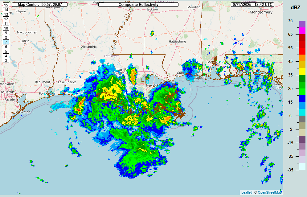
Rainfall is moving across south and east Louisiana this morning, as seen on radar at 7:45 CT. (NOAA NSSL)
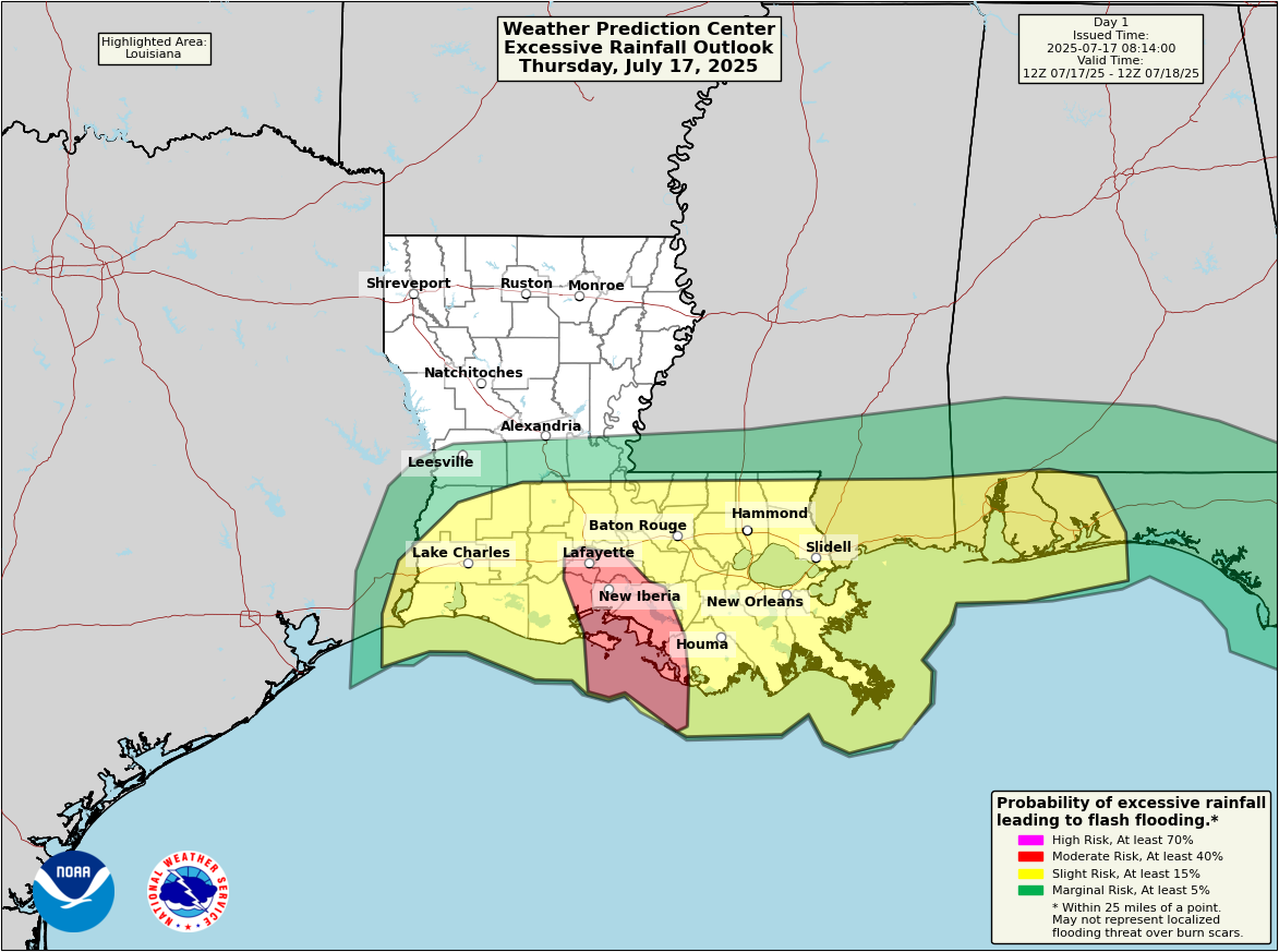
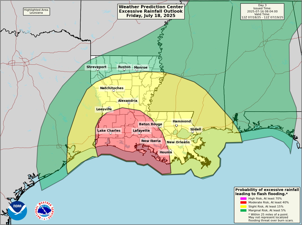
Given the current storm situation there, it would appear that several rounds of locally heavy rain are likely to push in through today and into tomorrow. The entire southern half of Louisiana is under a flash flood watch today, stretching from Lake Charles to New Orleans. The moderate risk for flash flooding (level 3/4) has moved into today and is focused primarily on the Atchafalaya.
A moderate risk for flash flooding today (level 3/4) for Lafayette and much of Acadiana. (NOAA WPC)
While the expected rainfall totals today won’t be overwhelming (probably on the order of 2 to 4 inches or some higher amounts), the rate of rain may be enough to cause some locally significant flash flooding. Should 93L slow down a good bit further as well, that would serve to enhance localized rainfall risks. More rain and thunderstorms are likely tomorrow as well.
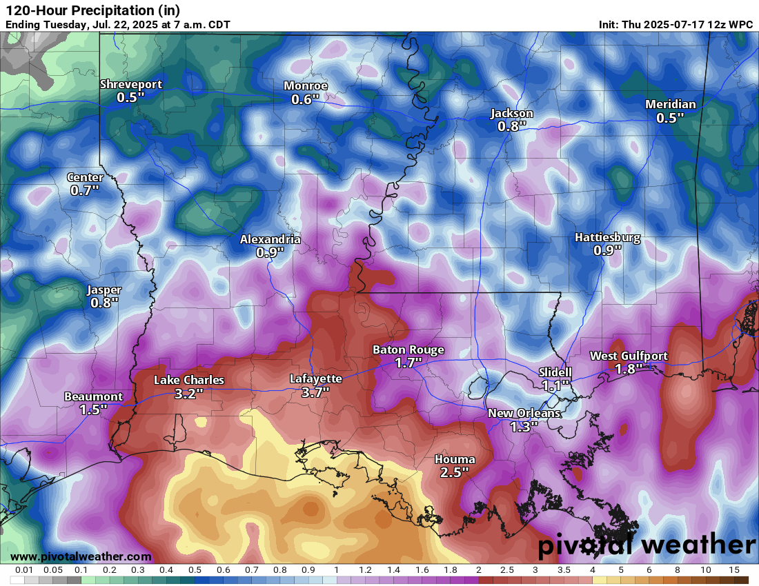
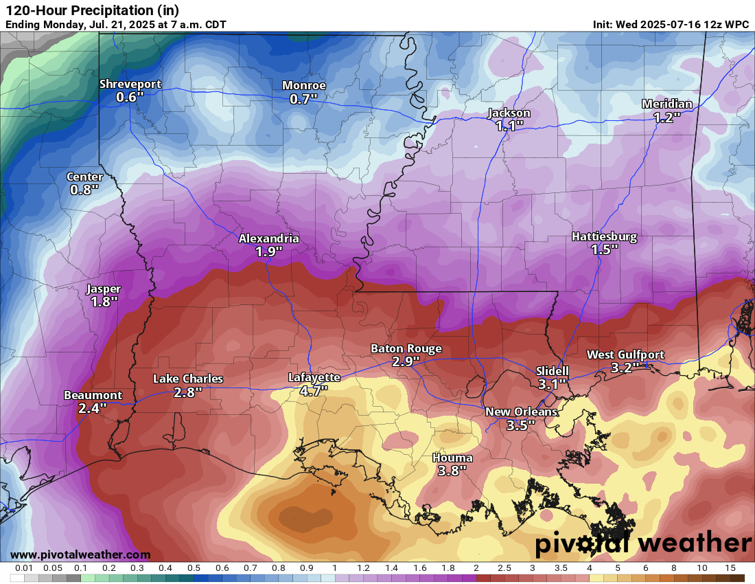
Rainfall totals expected across Louisiana through the weekend. Consider these values an average, where some places may see higher amounts and others lower amounts. (Pivotal Weather)
All told about 2 to 5 inches on average should be expected the next couple days. I would not be the least bit shocked if one or two spots did pick up as much as 6 to 9 inches of rain, but those would the exception rather than the rule I think. Overall, the flooding risks look a little less ominous than they did earlier this week, but they should not be discounted.
Rest of the Atlantic
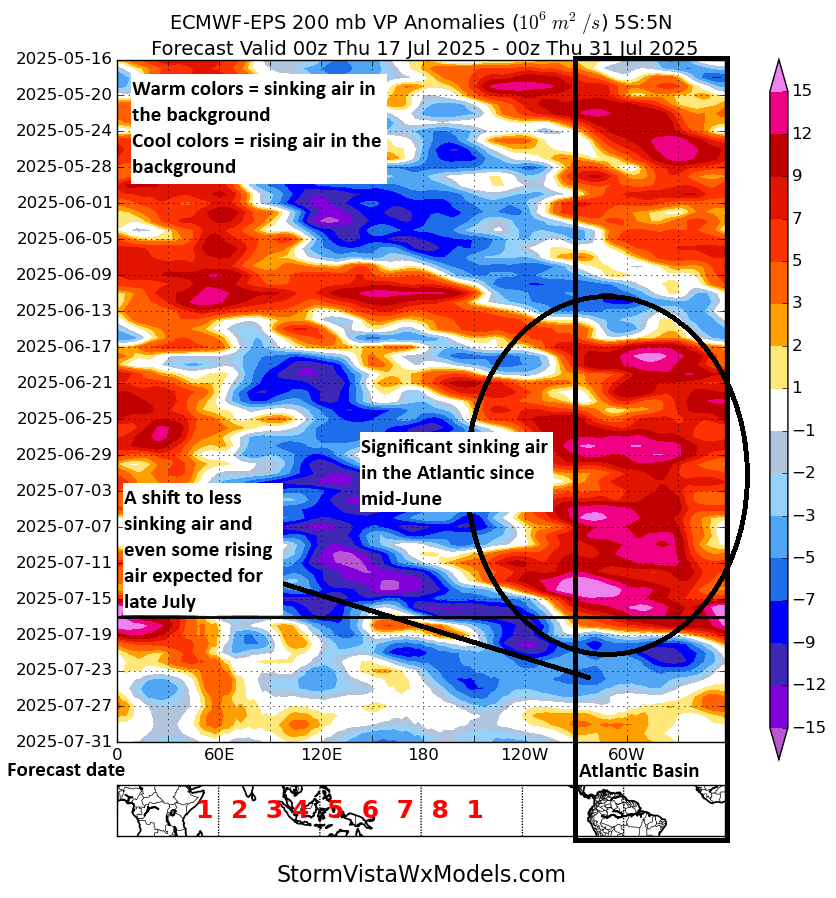
While most of Atlantic hurricane season thus far has been quiet, there may be some changes brewing heading into late July and early August. I want to note this because I also think some of these changes may be somewhat overhyped in some circles. It’s not as if the Atlantic pattern will suddenly turn very favorable. It will, however, turn less hostile.
The background state of the atmosphere will become somewhat less hostile as we close July across the Atlantic, but there’s no guarantee that means anything just yet. (StormVista)
From the plot above, you can see that the background state of the atmosphere is expected to work into more favorable territory by the time we get to next week across the Atlantic basin. However, it’s still sort of lacking a lot of teeth. I’m just not convinced of this being the catalyst to bring us big activity yet. However, this is the first assault on the wall of unfavorability that has gripped the basin since early to mid-June.
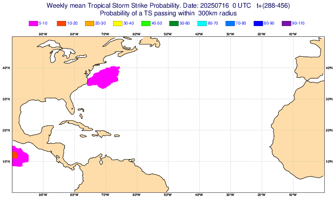
Meager probabilities of tropical cyclone activity are forecast in the Atlantic heading into the end of July and early August from the ECMWF subseasonal model. (ECMWF)
The European weekly model is not having any of it, though, going with very low probabilities off the East Coast to close July.
Right now, I see a pathway to a more active Atlantic, but I don’t see concrete evidence that it’s definitely coming. So for now we’ll just keep monitoring things.
Heat wave on the way?
When it comes to forecasting different weather variables, some end up better to forecast than others at longer lead times. Hurricane tracks at 10 to 15 days out? Probably poor! Total precipitation 10 to 15 days out? Probably a bad forecast. Will it be wetter or drier than normal? That’s a slightly higher confidence forecast depending on each weather pattern. How about heat waves? Well, let’s discuss that today.
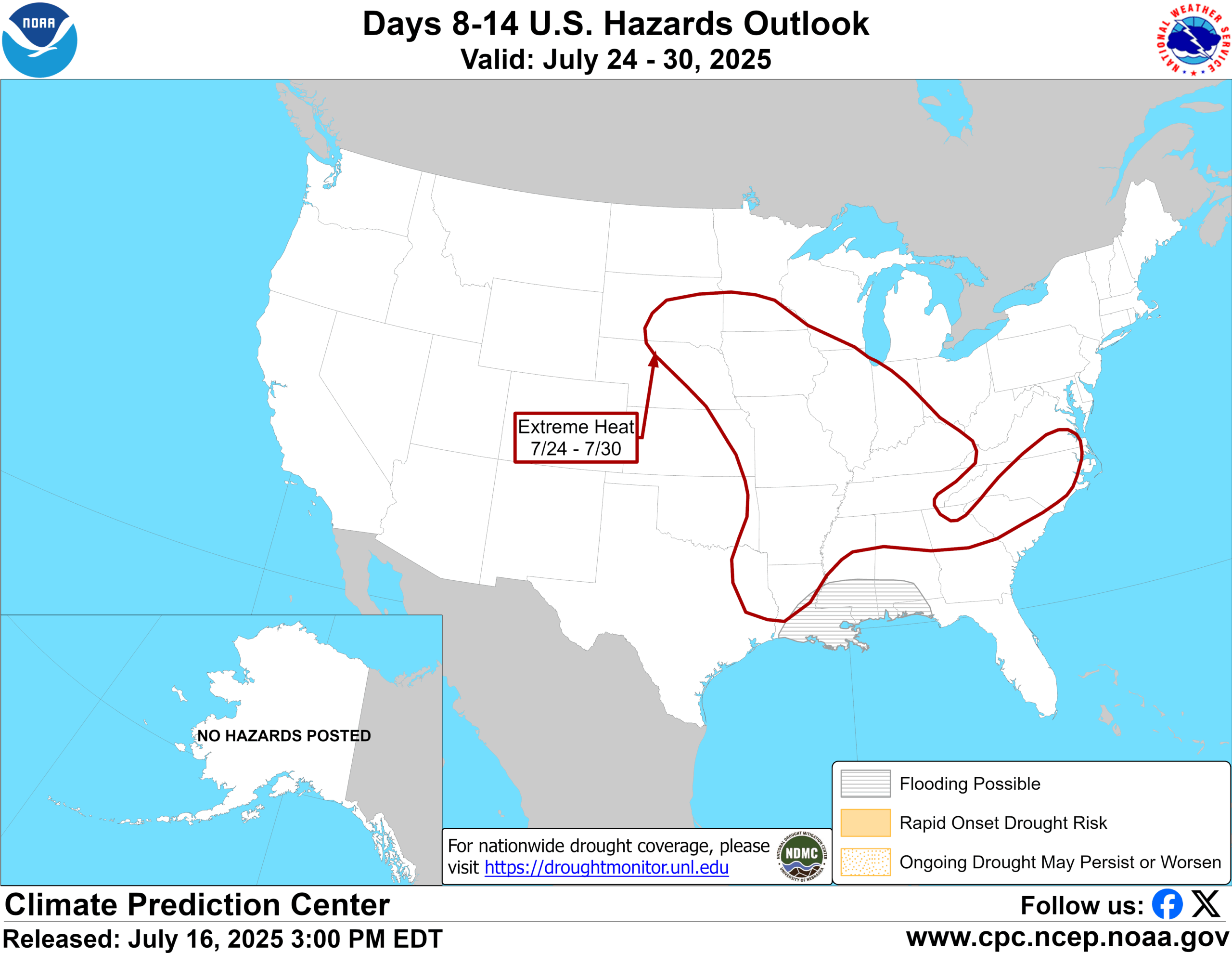
There have been some signals in the models over the last couple days for an expanding ridge of high pressure across the middle of the country in the 10 to 15 day forecast period. Yesterday afternoon, NOAA’s Climate Prediction Center added the risk of “extreme heat” to their forecast for July 24th through the 30th across a broad expanse of the country from the central Plains into the Southeast.
The Climate Prediction Center is calling for the potential of continued flooding risk in the South, as well as potentially extreme heat in much of the eastern half of the country to close July. (NOAA CPC)
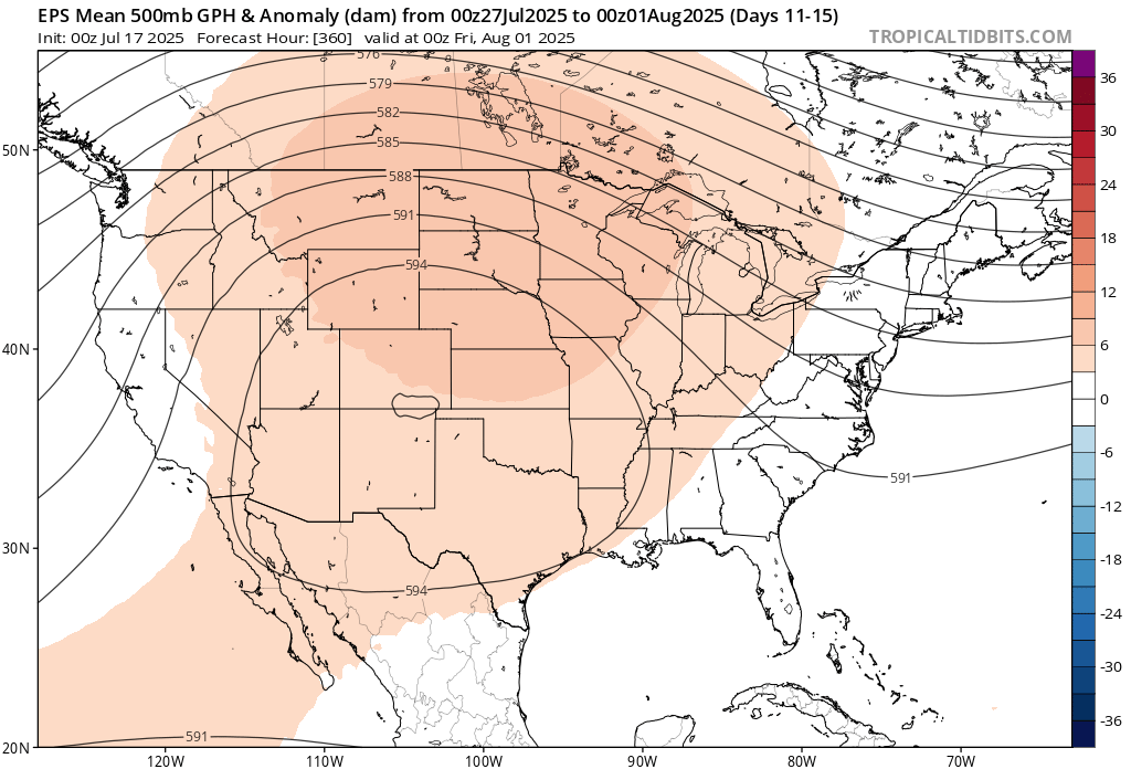
When we look at the broad weather pattern that is forecast from the European ensemble mean, an average of 51 ensemble members to produce a forecast for the 11 to 15 day period, you can see that there is a very strong signal for above average heights in the upper atmosphere, a signal for hot weather.
A significant ridge of high pressure may evolve over the Plains to close July, leading to a substantial heat wave across much of the country. (Tropical Tidbits)
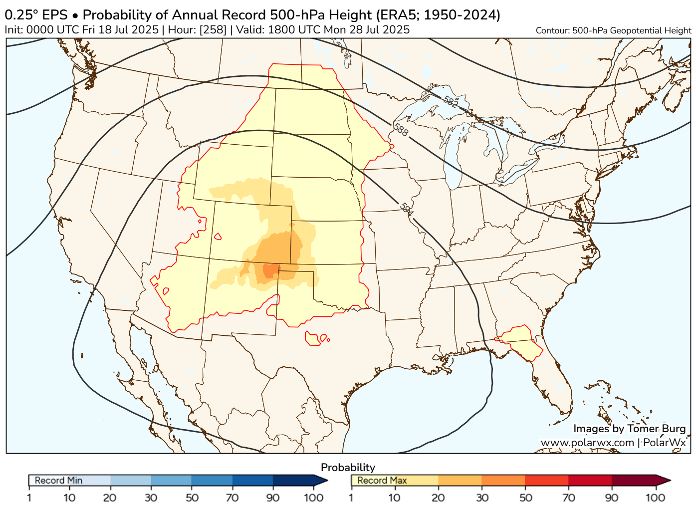
In fact, if you look at the potential for annual record 500 mb heights, or how many of the ensemble members are predicting that the intensity of the ridge will break all-time records, somewhere in the range of 20 to 30 percent of the European ensemble members are calling for just that. That’s a very impressive signal at this lead time.
Roughly 20 to 30 percent of European ensemble members are forecasting record heights in the atmosphere over the Plains at the end of July, which indicates a strong chance for a significant heat wave. (Tomer Burg/PolarWx)
Now, the Euro has been wrong before at this lead time. In fact, even a couple times this year it’s overestimated the heat somewhat. However, this is a slightly different scale and setup, and it has additional support from the 51 member European AI model ensemble as well. Record or not, it appears that there will be a significant bout of summer heat coming again in the day 10 to 15 timeframe as we head toward August. More to come on this.
Flooding notes: Is Waco, Texas prone to destructive flooding?
Just want to close today with a shoutout to the Waco Bridge, a new independent news site covering Waco, TX. They put together a nice piece yesterday that discusses the flood risk specific to the city of Waco. While there have been historic floods there in the past, a number of engineering projects over the last 50 to 75 years have dramatically lowered the risk of a catastrophic flood there. Not to say serious, if not destructive flooding cannot happen; it can happen virtually anywhere in this country. But there has been risk reduction. I know we have a number of Texas readers, so this may be a good story to share with any friends or family in the Waco area. There are also a number of good links in there for some real-time and forecast flooding data from across Texas.
Periodically, I will effort to point out stories from local news sources from around the country that touch on localized flooding risk or risk of other weather-related vulnerabilities.
In brief: Invest 93L is unlikely to develop much at all, but it remains a flooding risk for Louisiana heading toward Friday. We also take a closer look at flooding that has occurred in the Southside of Virginia, specifically near Petersburg.
Invest 93L
Before we begin on this disturbance, I am going to shout out a post at our Houston-focused site, Space City Weather. The amount of bad information on the northeast Gulf system that is coming from one specific source, TikTok, is almost incomprehensible. One of the main reasons our sites exist for Houston at SCW and here for others is to provide an honest forecast and information about weather from experts that are aligned with a mission of informing without being patronizing or condescending. When it’s boring, we’re boring. When things get interesting, we get interesting. We also want to make sure folks keep their eye on the ball. When it appears a storm is going to threaten southwest Florida and the media hasn’t left Tampa, we want to highlight that. When a storm is a flooding threat and has no realistic chance of becoming a hurricane, we want to focus on that. So, thanks for reading and please keep spreading the word!
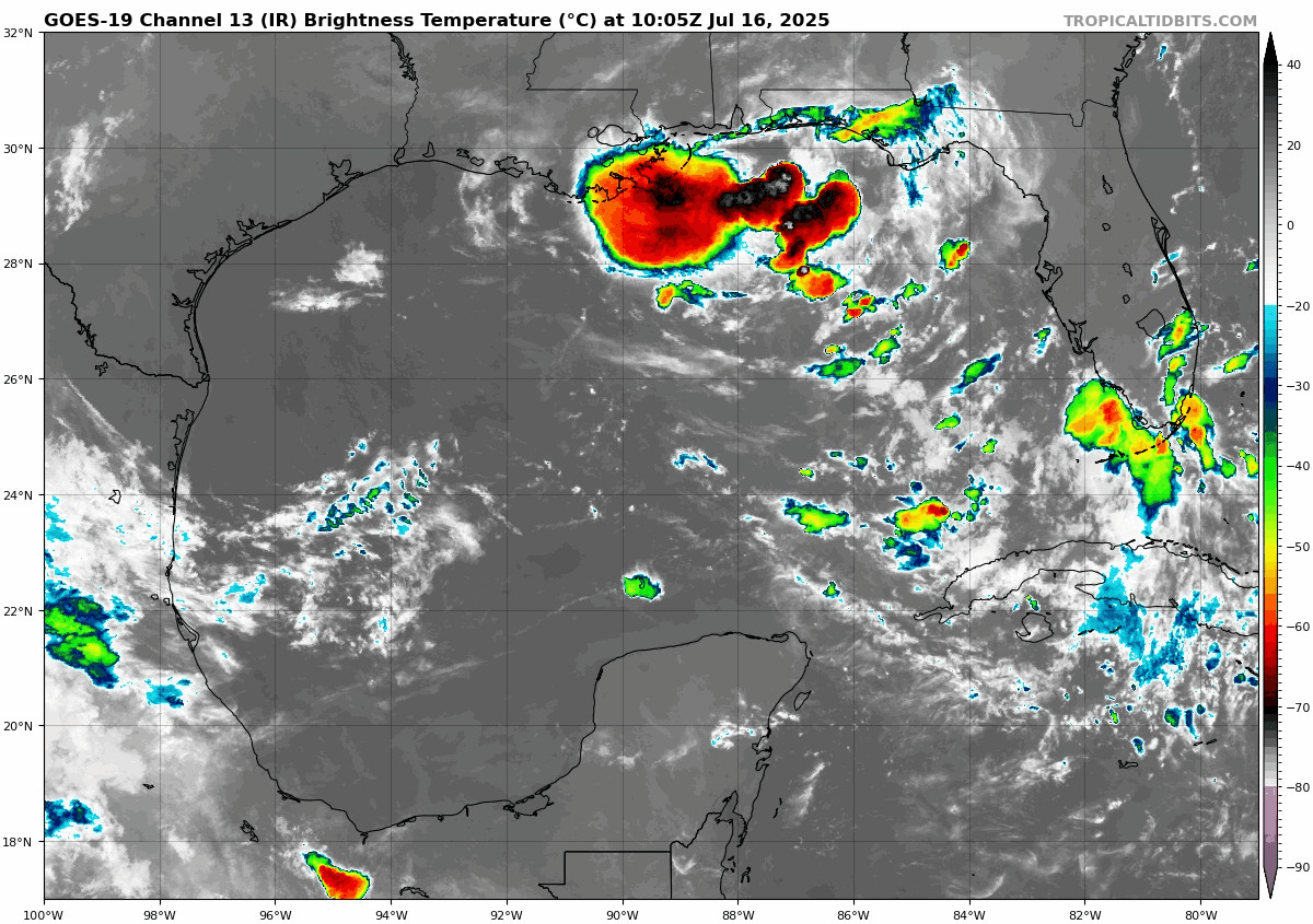
Invest 93L did a good thing yesterday, coming off the Florida Peninsula farther north than expected. This will keep it closer to land and probably keep it from developing much, if at all.
Gulf satellite image showing Invest 93L in the northeast, very disorganized but producing some heavy thunderstorms. (Tropical Tidbits)
It’s not really possible to pick out a true “center” on the satellite image, but it’s somewhere near or south of Panama City. Intensity-wise, the forecast for 93L is pretty straightforward. The majority of modeling including the “corrected consensus approach” product that has had significant success in recent years keep this barely a tropical depression. Very few models bring 93L to tropical storm intensity. The NHC odds have held steady at 40%.
Let’s talk rainfall, because that will continue to be the primary story here.
A moderate risk (3/4) exists for flash flooding in Louisiana on Friday. (NOAA WPC)
A moderate risk of excessive rainfall exists by Friday in Louisiana. The flash flood risk here seems a little less scary today, but it’s nevertheless serious.
Rain totals through Monday morning should be on the order of 3 to 6 inches across much of Louisiana which could cause flooding. (Pivotal Weather)
The total rainfall forecasts seem to have backed off a little, now down to 3 to 6 inches across much of southern Louisiana for this event. Still, that may cause flooding and with locally higher amounts, locally more significant flooding remains a concern, primarily between tomorrow evening and Saturday. 93L should basically dissipate and get absorbed into the broader weather pattern over the Southeast once again by next week.
The Virginia Southside flooded multiple times
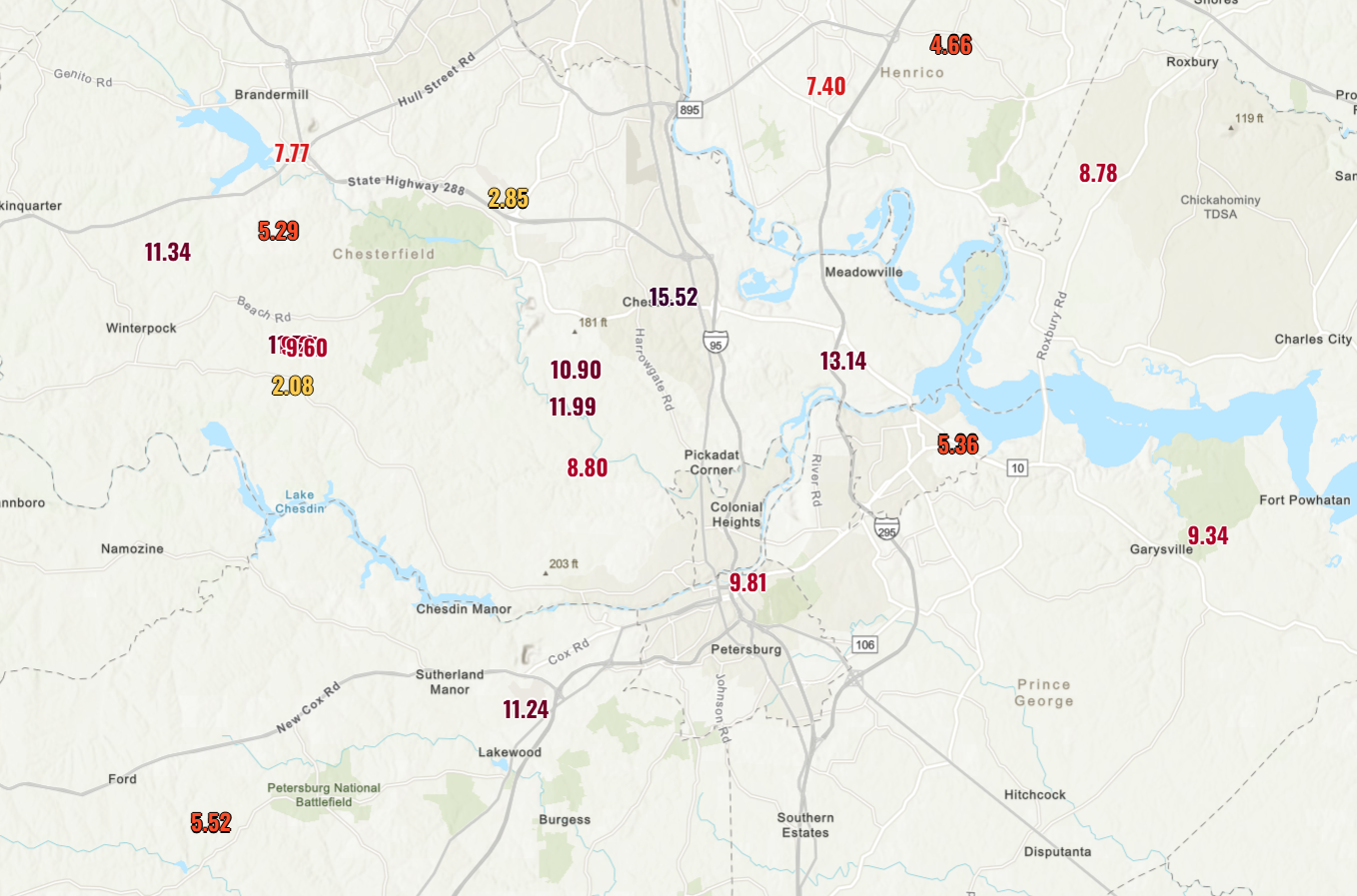
It’s been a rough week just outside of Richmond, Virginia. Petersburg has been under 13 flash flood warnings this month. It finally broke yesterday with flash flood emergencies, significant flooding, a state of emergency, and a lot of frustration about systemic neglect of mitigation measures.
7 inches of rain more than usual have fallen so far this month in Petersburg, Virginia. (High Plains Regional Climate Center)
Some parts of the Southside of Virginia have seen north of 10 to 12 inches of rain this month, and it’s taken a toll.
Rainfall so far this month south of Richmond and in the Petersburg and Colonial Heights areas has been remarkable. (NOAA)
And some food for thought here: The problems in Petersburg are a microcosm of the problems facing hundreds of cities in this country. Many are plagued by poor drainage during heavy rain and backlogs of projects that would help ease the problems. The cost to get these projects across the finish line would be astronomical, and with a moving target (heavier rainfall rates as the climate warms), there’s no guarantee that even funding the wish lists of every community would lead to a successful outcome.
In brief: More flooding, this time in New Jersey in particular, as well as Florida. The next serious flooding event may unfold thanks to Invest 93L later this week in Louisiana.
Note: Most of the data in these posts originates from NOAA and NWS. Many of the taxpayer-funded forecasting tools described below come from NOAA-led research from research institutes that will have their funding eliminated in the current proposed 2026 budget. Access to these tools to inform and protect lives and property would not be possible without NOAA’s work and continuous research efforts.
Another round of flooding
First of all, if you think this year has been busy in terms of flooding, it has. Let’s just look at the Southeast as an example, since we’re going to focus a lot there today. So far, over 650 flash flood warnings have been issued in 2025 for the Southeastern U.S. If the year ended today, it would not be near last place for most flash flood warnings in a year.
Accumulated flash flood warnings by year (for the entire year) for the Southeast. (Iowa State Mesonet)
In the South-Central part of the country, it’s not a whole lot different. We’re well over 1,000 warnings on the year for flooding.
South-Central U.S. flash flood warnings by year. (Iowa State Mesonet)
We saw more of it yesterday, this time in the New York City metro area and down in Florida.
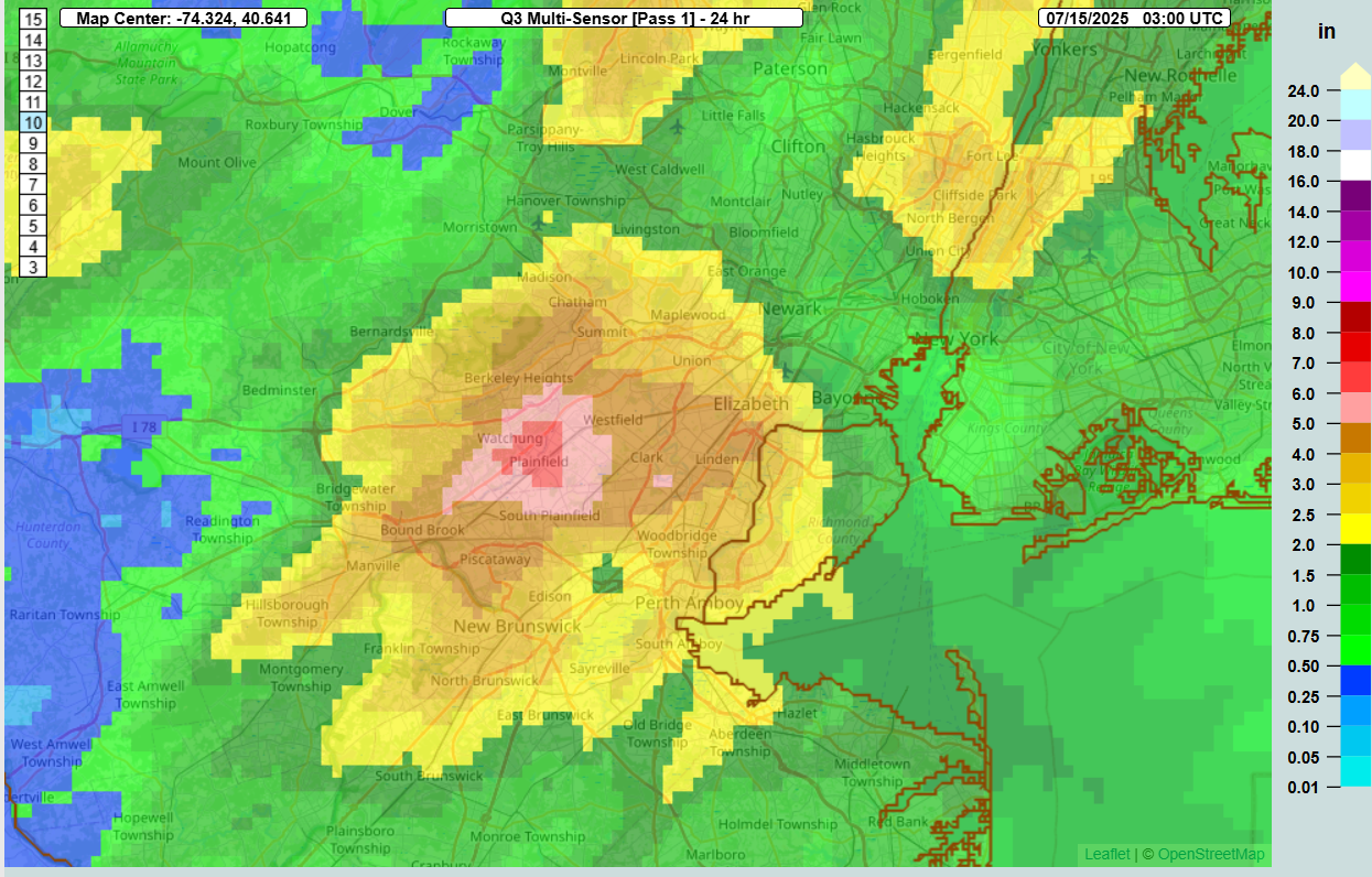
In northern New Jersey, rainfall totals probably came close to 7 inches in spots right near the Watchung Ridge up in western Union and northeast Somerset Counties.
Radar estimated rainfall bullseye of 6 to 7 inches right over Plainfield, NJ yesterday. (NOAA NSSL)
This type of rain has about a 2 to 3 percent chance of occurring in any given year in this location. Numerous reports of flooding were received in parts of New Jersey, as well as in New York City, as rainfall rates of around 2 inches or more per hour overwhelmed drainage systems. Heavy rain also fell west in Pennsylvania, west of Scranton-Wilkes Barre, with about 1 to 2 percent probabilities of those totals occurring in any given year. A secondary area occurred near Lancaster, PA as well.
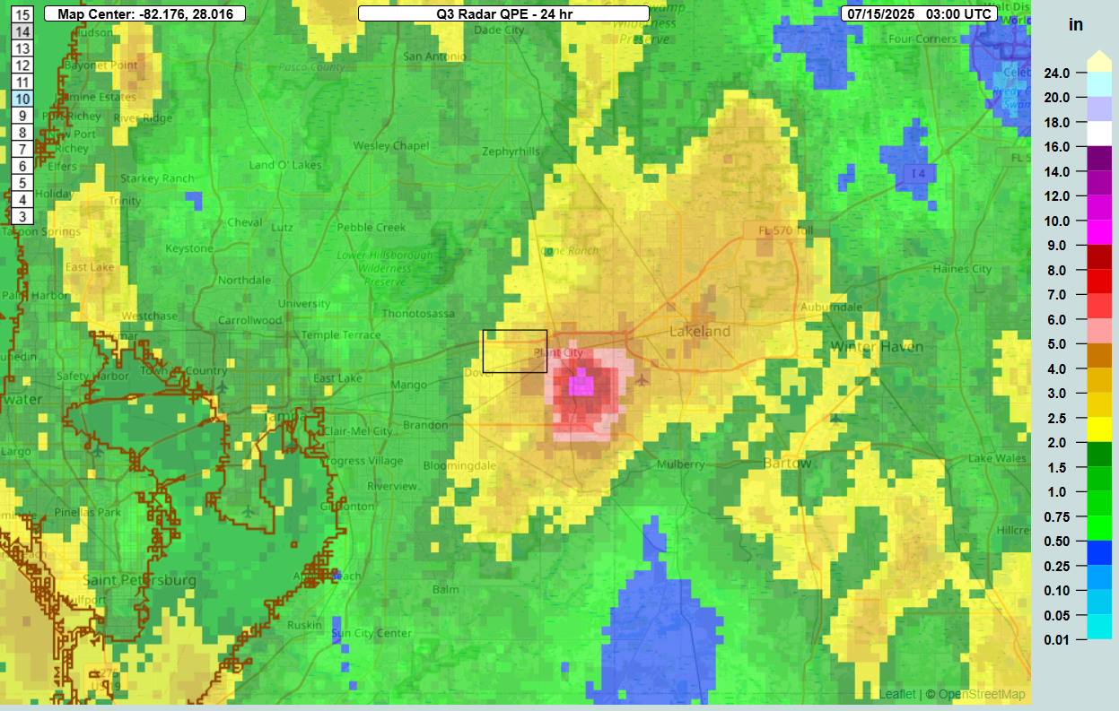
South into Florida, much of the state saw rain yesterday, but the Plant City and Lakeland areas were especially hard hit. Rain totals of as much as 6 to 10 inches occurred just southwest of Lakeland, with flooding reported there as well.
Rain in Florida was widespread, but very isolated pockets saw extremely high totals, such as in Plant City. (NOAA NSSL)
Just another day in this seemingly frenetic summer.
Tropical Disturbance: Invest 93L
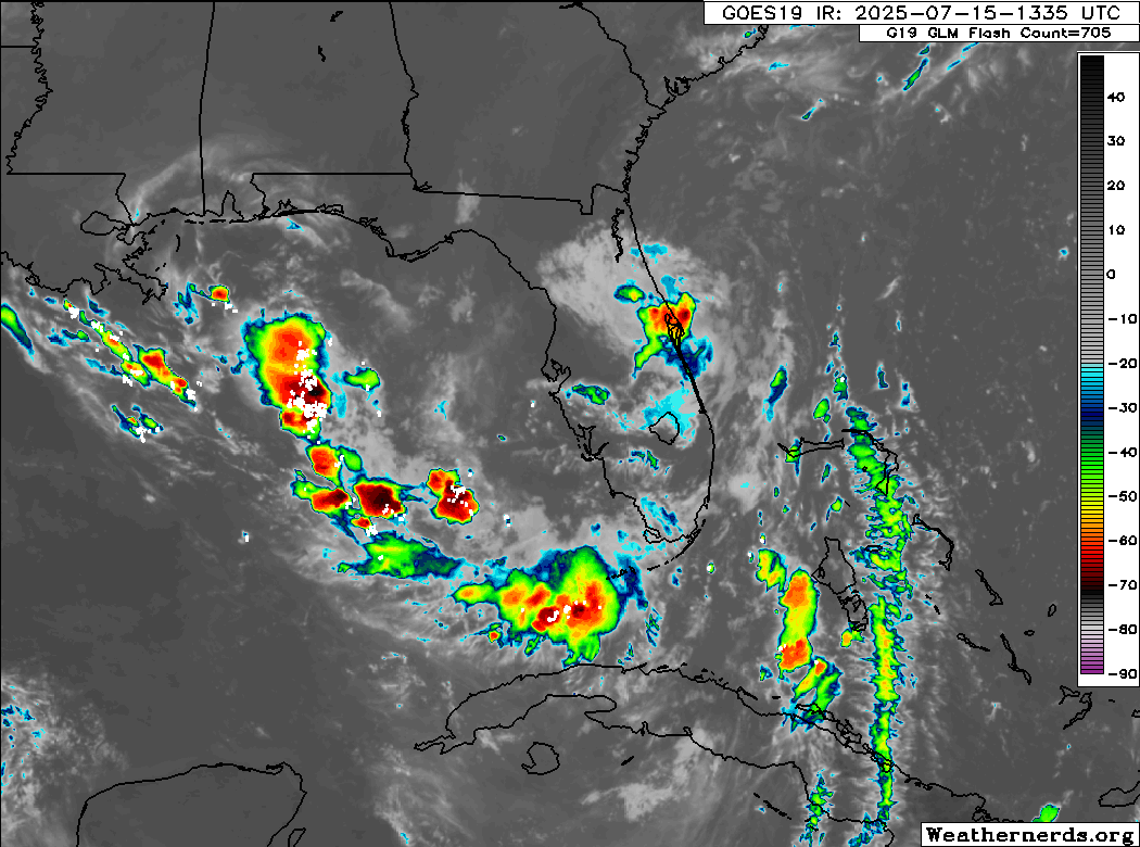
There’s so much to talk about today in terms of all sorts of things, but we will focus first on the potential for a tropical system in the Gulf. Currently, Invest 93L is moving onto the Florida Peninsula. If we’re really being honest, it ain’t much to look at today.
Invest 93L is moving onto the Florida Peninsula this morning. (Weathernerds.org)
Once into the Gulf it will encounter both very warm sea-surface temperatures and slightly less wind shear. This will allow it to begin to get its bearings and make an effort to organize. Currently, the NHC is giving it about a 40 percent chance of development the next couple days as it moves west across the northern Gulf. Obviously, you see something in the northern Gulf, and it’s instinctive to get a little worked up. This will probably have limited time over water, and the proximity to land is likely going to work against it some. There’s also likely to be some drier air in play here. All this to say that it would seem that the ceiling on this system is fairly low in terms of intensity.
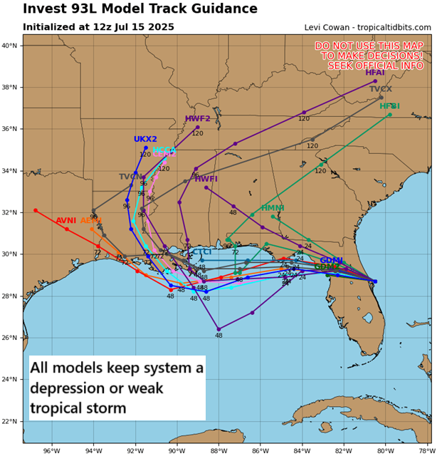
Tropical models are generally focused on Louisiana for the track of Invest 93L. (Tropical Tidbits)
In terms of the track, it is likely to work west across the Gulf generally toward Louisiana. A weaker, more disorganized system would probably work inland west of New Orleans. A stronger system, for whatever reason, may come ashore farther east. The next name on the storm list is Dexter.
But given the low ceiling, I think it’s important to focus on the rainfall risk here.
Rainfall risk on Gulf Coast
Gulf systems this time of year typically have characteristics that make them very sloppy, very lopsided, and very wet. In other words, they’re often a flooding threat. And this appears to be the case here as well.
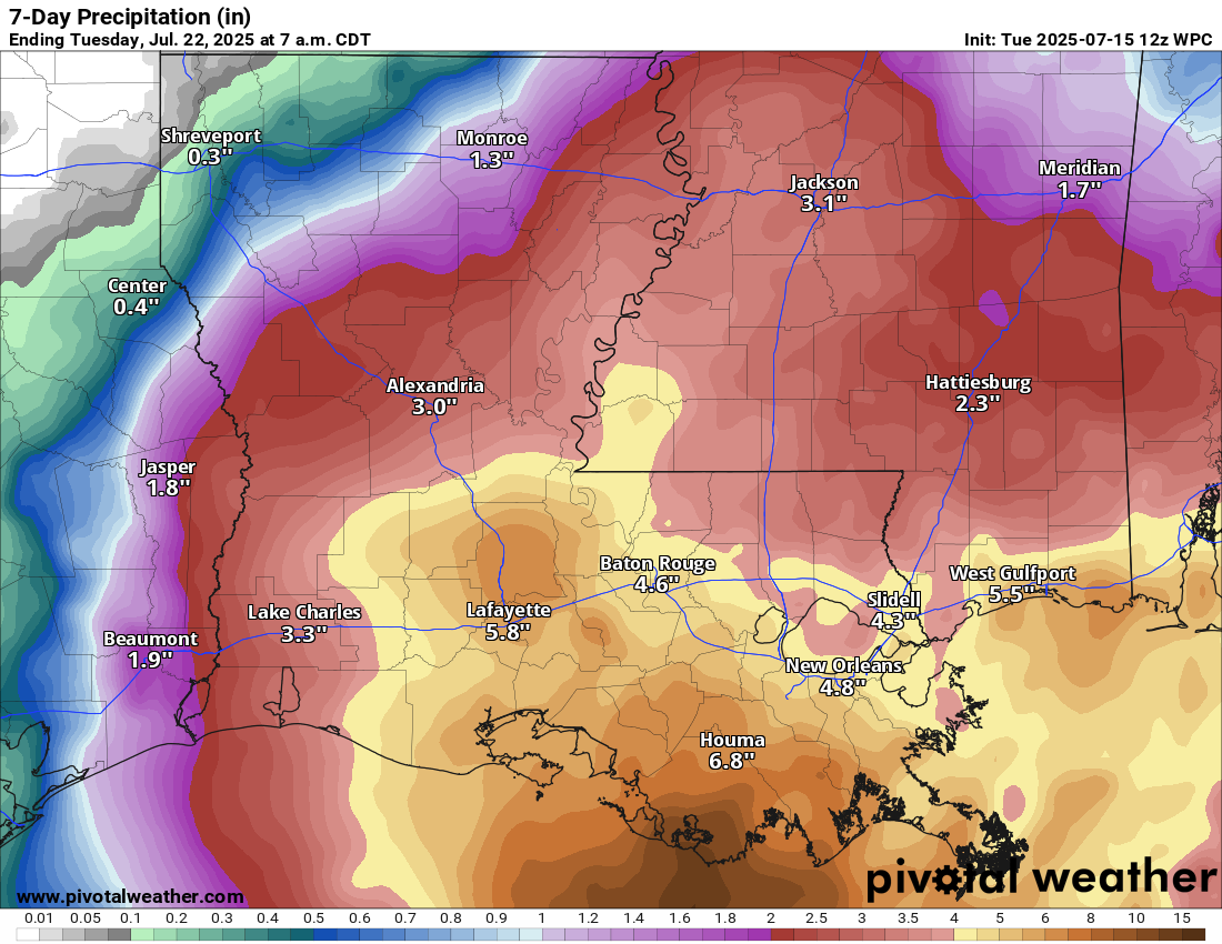
The 7-day rainfall forecast for Louisiana and the Gulf Coast of Mississippi shows upwards of 4 to 8 inches of rain or more possible. (Pivotal Weather)
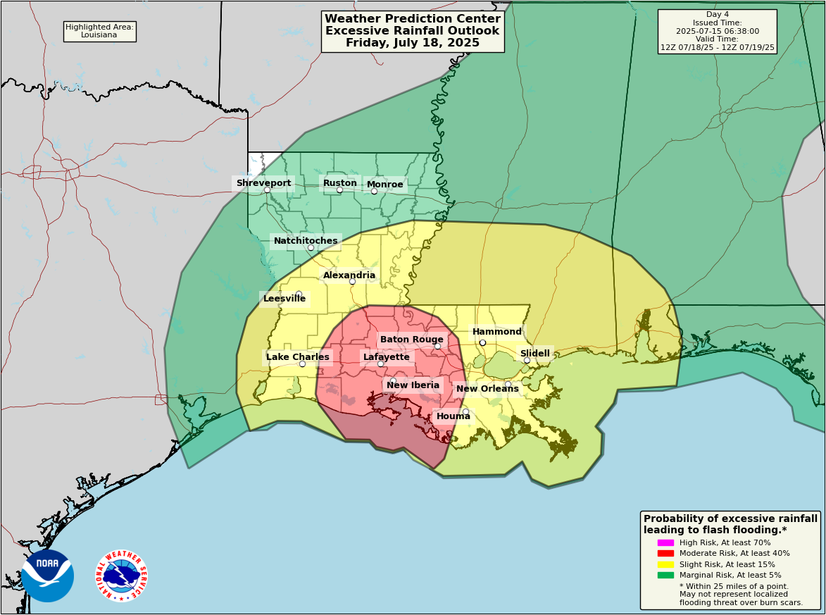
The current rain forecasts show upward of 4 to 8 inches of rain across much of Louisiana and coastal Mississippi. Heavy rain will also extend east into coastal Alabama and the Panhandle of Florida as well. In fact, there is already a moderate risk of flash flooding (3/4) for day 4 in Louisiana (Friday).
A moderate risk of flash flooding exists for Acadiana on Friday (NOAA WPC)
The focus of the flooding risk will be on Acadiana and the Atchafalaya Basin. This includes both Baton Rouge and Lafayette. It’s still a bit early to focus on high-end risks of how much rain could fall, but I would keep a very close eye on the forecast between Beaumont and Baton Rouge from the flooding and heavy rain risk point of view.
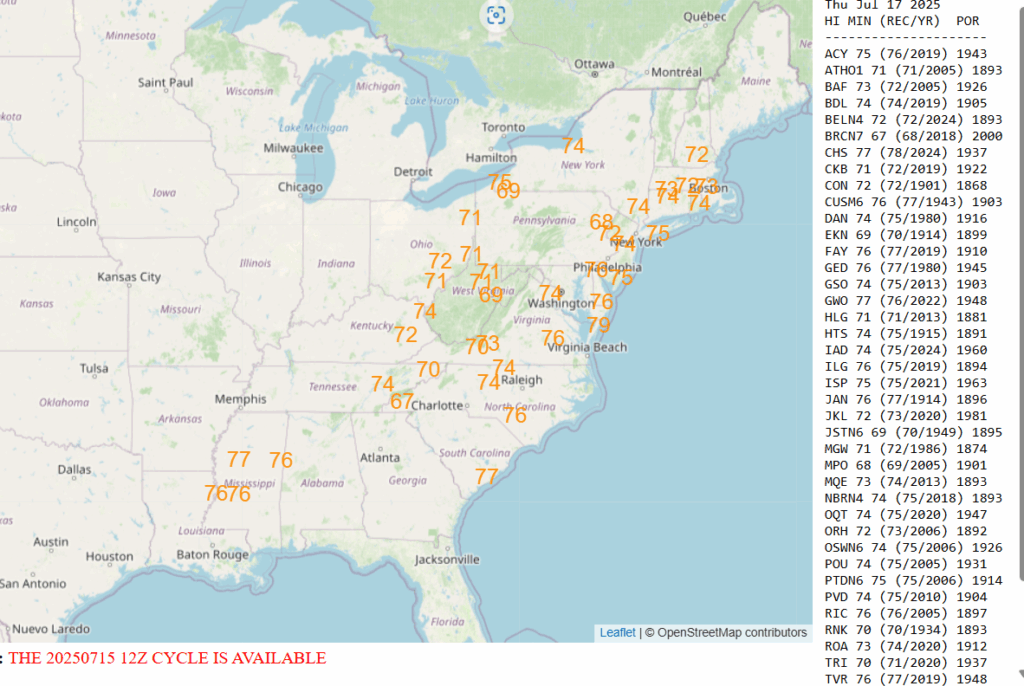
On the east side of 93L, a very warm and humid air mass will lead to hot and uncomfortable weather later this week up the East Coast. Numerous record warm low temperatures are at risk of being broken.
Numerous record warm lows are at risk on Thursday morning. (NOAA WPC)
We’ll have more tomorrow morning or later today if anything significant changes.