Headlines
- Leslie heading out to sea while Invest 94L may develop just west of the Cabo Verde Islands.
- We are monitoring the western Caribbean next weekend, but there is still nothing of specific significance that we can state about the potential of development, and we urge you to not fall prey to one-off model runs that show scary outcomes.
- Thank you to our Friday featured sponsor: Senior Health Services!
- The close of our post talks a bit about or mission and goal for this site, as well as what we don’t want to be!
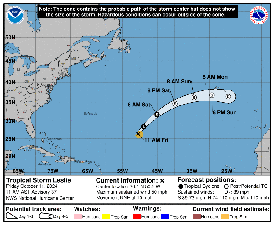
Leslie and 94L way out in the Atlantic
We’re beginning a period of calmer conditions in the tropics. At least as it relates to land-impacts from tropical systems. Milton is now history. Leslie is still churning away in the open Atlantic but it too will soon be history.
Off the coast of Africa, we currently have Invest 94L. This looks ready to pop in the next few days. Model guidance agrees on this, and the overall environment looks decent. Steering winds should bring it west across the Atlantic.
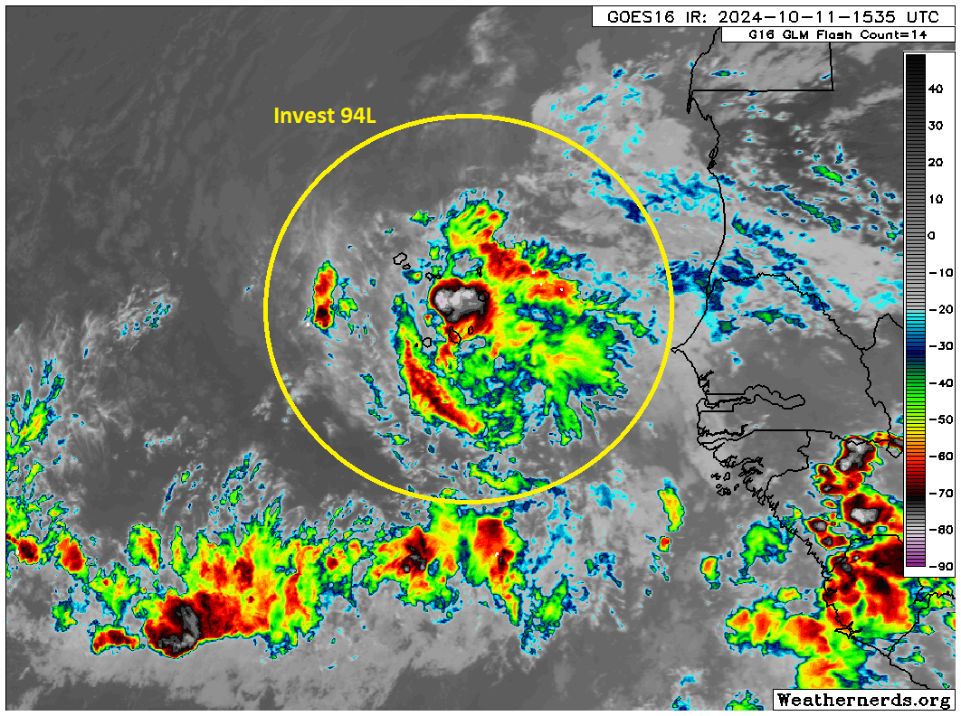
While this is unlikely to threaten the U.S. at any point, this is at least something to monitor if you live in the Caribbean. It’s still a solid week away, but with water temperatures still sitting near all-time records in the Main Development Region (MDR) of the Atlantic, the right environment could easily incubate a strengthening storm.
That said, this would be unusually far east for a storm to develop this late in the season. Only one system has formed east of the Cabo Verde Islands since 1851 in mid-October, and only a couple others within 10 degrees of longitude west of there. If 94L forms soon, it would be an oddity. Most storms that form in the central or eastern Atlantic this late in the season tend to curve out to sea before getting to the islands, but obviously some have come close.
We’ll keep an eye on 94L and have more for you Monday.
Eyes on the Caribbean?
There was one particular GFS operational model run yesterday that sent some folks into a tizzy over the potential for a big hurricane in the Gulf in about 10 to 12 days. I want to remind you all that operational model runs like that specific GFS run are not suited to trust more than 5 to 7 days out. Even within 5 to 7 days there are often issues and miscalculations with the model. So don’t panic when you see that.
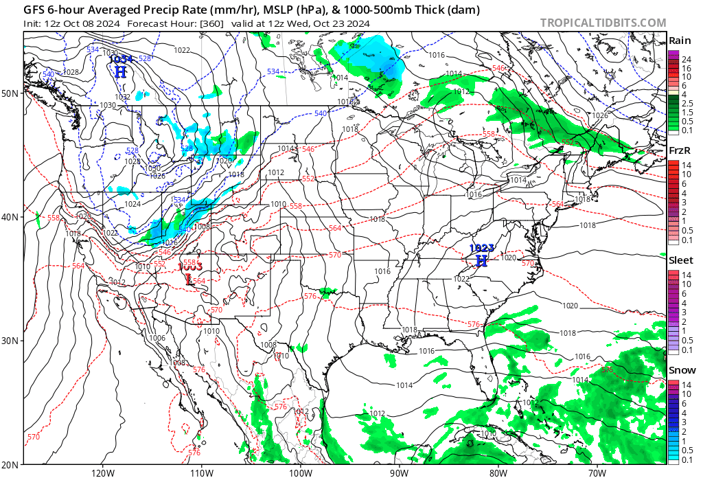
No consistency, no trustworthiness.
Most models agree in a tropical disturbance trying to form in the western Caribbean sometime later next week.
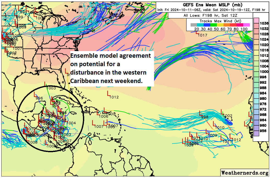
This is a century away in model terms, and there is very little agreement on where things go from here, if anywhere at all. We have a very long time to watch this area, but I would encourage you not to stress over things. A lot of moving parts will impact whether or not this develops, including cold fronts, locations of specific features, etc. Right now, we simply have nothing intelligible to really say about this other than a disturbance is possible there in a week’s time. Anyone selling anything specific at this point should be added to your “do not trust” list immediately. More on this Monday.
Friday featured sponsor: Senior Health Services
Thank you to Senior Health Services and all our sponsors for their support of The Eyewall this season!

Need help with Medicare? Is your plan changing? Senior Health Services is a full service Medicare brokerage providing free Medicare help. Millions of Americans on Medicare are seeing changes to their plans due to the Inflation Reduction Act. If your plan benefits are changing, benefits being cut, costs going higher, or even terminated altogether, we stand ready to assist. We work with Medicare Supplements, Medicare Advantage, Part D plans, and more. If you need help, it’s free! All you have to do is visit us at seniorhealthservices.com or call us at 281-894-7540. We serve most states. Did we mention it’s free? Don’t do it alone. Call us if you need help.
A final word
We have had some very spirited comments in recent posts, which have been useful and interesting conversationally! We encourage that. We just ask to keep it respectful. I don’t want to have to moderate or shut things down at any point. We trust y’all to treat each other with courtesy.
Secondly, I just want to clarify a couple misconceptions I read. We did not build this site for Houston. While we hope Houstonians will use it as a companion to the robust information we offer at Space City Weather, we built this site for everyone else, truthfully. There are a handful of good blogs out there talking about the weather, and we want to join them. I hope any of you in Florida, Georgia, Louisiana, or the Carolinas will share this site with your friends and family. We try not to advertise and prefer our growth to be by word of mouth in most cases. Let our work speak for itself.
There are two primary reasons we don’t post 5 or 6 updates a day when a storm threatens someone. First, honestly, not a whole lot changes from morning to evening. Yes, a storm can rapidly intensify or change intensity but in general, that doesn’t have a massive impact on the forecast, and if it does, in most cases a second post later in the day will cover it. We live in a world with frequent, *URGENT* push alerts. We aren’t that. We don’t want to oversaturate you with repetitive stuff just so we can show we’re still on top of things and generate traffic for the sake of traffic. We want our posts to carry value and information, not regurgitation. Second, we are not local experts on Tampa or Jacksonville or Cape Hatteras or Charleston. We could never be. We know a bit, in some cases a lot about geography. But the local nuance can only be covered by local experts. That’s why at a point, we want you to find trusted local sources of information to turn to, such as your local NWS office or a particular broadcaster or online source in your region. Simply, we cannot do at scale what they do for you locally. So yes, please use us! But make sure you’ve got someone not from Houston that you’re following to give you that local insight or nuance that you need.
As always, thanks for your support, follow us on social media, and share us with your friends and family!
Facebook
Instagram
TikTok (we will occasionally cross post from Instagram there)
Twitter/X
Threads
Bluesky
Mastodon
Thank you for all of your diligent and fact based (no hype) work. Trust is difficult to find these days in our “urgent” social media world. Thank you for contributing to the lowering of the noise.
If I could upvote this post, I would. Well said.
Agreed!
I love what you are and how you do it. Keep on keepin’ on and I’ll keep spreading the good word. -from Western North Carolina
Thank you a million times for the work that you do and for starting this site for the “rest of us.” We moved to Florida from the Houston area, which is where I first “got to know you” via Space City Weather. I was sad when we first got to Florida bc I missed your calm, reasonable, and reliable takes on the weather. But then you started this site! I recommend you to everyone – and again, I’m just so appreciative of the work you do. I was prepared well in advance for Milton bc of your site.
I think that some confusion about “Houston centric” is that many of us found “Space City” first and when storms threatened both Louisiana and Texas we over here in Louisiana were using Eric’s Space City page for info and then got turned on to “the Eyewall” by that page.
As someone that for 4 decades used Nash Roberts until he retired I was desperate for non-hyperbole storm info. As far as I was concerned, unless you were trying to give yourself a heart attack the Weather Channel was worthless. I wouldn’t be surprised if they started yelling right now about 94L going to kill us .. LOL!
I like weather.com for their radar and other data. But man, the front page can be pretty absurd!
quoting.
We did not build this site for Houston. While we hope Houstonians will use it as a companion to the robust information we offer at Space City Weather, we built this site for everyone else, truthfully.
….
Second, we are not local experts on Tampa or Jacksonville or Cape Hatteras or Charleston. We could never be. We know a bit, in some cases a lot about geography. But the local nuance can only be covered by local experts. That’s why at a point, we want you to find trusted local sources of information to turn to, such as your local NWS office or a particular broadcaster or online source in your region. Simply, we cannot do at scale what they do for you locally.
.
It could be because of my age, and my mind going mushy … but those two quotes contradict each other, correct?
Okay, “the site is not built for Houston area folks … but we’re not experts away [from the Houston area]”.
Can someone clarify my potentially erroneous interpretation (?)
Sure, they are tropical weather experts, not experts of particular areas. Of course they know their home city better than the nuances of places on the other side of the country.
The Eyewall site is a tropical weather site for everyone interested in the tropics, particularly Gulf & Caribbean zones, as compared with the Space City Weather site which is Houston-centric.
The Space City Weather site is specifically for Houston, Texas. The weather systems that are discussed are systems that can and/or will affect Houston, Texas (with some surrounding areas). It deals with ALL weather that affects Houston, not just hurricanes. It is a near-daily blog that lets us know, for the most part, what to expect from the weather in HOUSTON (in a calm, reasoned manner).
This site – The Eyewall – is for information regarding tropical storms forming/formed in the Atlantic Ocean basin, along with the Carribean Sea and Gulf of Mexico (mainly). Totally different from SCW. It calmly keeps an eye on weather systems possibly developing into tropical storms and their progress and/or demise. It is SPECIFIC to tropical systems threatening to become hurricanes.
If a hurricane/tropical system threatens the Houston, Texas, area, then these two sites most likely will overlap. Otherwise, they never would.
He is just saying that if you live elsewhere – so that Houston weather does not apply to you – that you should find a good local weather blog that posts specifically about your local weather in a calm manner. For instance, if you lived in Savannah, Georgia, you would look to a non-hyped online weather blog for local weather, while you could also view The Eyewall for tropical weather system updates. (Many people feel the local major TV channels have weather that is too hyped-up, for ratings, so they try to find a more reasoned outlook online.)
Hope this clears up your confusion!
I think they mean, they can tell you about the weather in other states, but they can’t tell you the ramifications of a hurricane in hurricane, i.e. what places are most likely to flood, what it means for their infrastructure, etc.
Not only will 94L probably not affect any land areas (except for the Cabo Verde islands), but the NHC is not expecting it to last much longer after Saturday, when conditions become “less conducive for further development.” As for the western Caribbean, it’s just too early, but what I’m seeing as of now is a low pressure system spinning up around the 19th, moving west onto the Yucatan peninsula and dissipating. No doubt that will change.
Grateful reader here in New Orleans.
Really appreciate your insights and found them invaluable for Francine, Helene and Milton.
Thank you!
Richard
Thanks Matt for all you do I. This blog. Good addition to SCW and I now read both daily.
I concur!
Not focusing on singular runs of the GFS, but I very much hope that last slide with rain all over Texas but no hurricane comes to pass.
A good, non-tropical rain sure would be nice! Looks like I’m going to have to start watering the foundation of my house.
I move to north east Texas and still follow you because when it comes to tropical weather you offer facts not hype and I send your link to all my friends. Trust is utmost and you have that.
Thank you for all the coverage! Incredibly useful!
Matt And Eric, you you guys do a great job. Ignore the neurotics. You will post us when you need to. I trust in your timing. Great job and I’ve donated yearly and will continue to support you.
I think you folks are doing a great job. You don’t “sell “ us the weather , like they do on the networks or on other websites, you tell us what you think will happen . Keep up the good work and honest analysis.
Keep up the good work! I have told so many of my friends here in Southeast Florida about your site and we all read it faithfully during hurricane season. We appreciate how easy it is to understand and the fact that you don’t give into fear porn! THANK YOU!
I live in west central Florida, and we certainly have very capable local meteorologists that are our go-to sources. I still read your posts for a no-hype factual information and big picture perspective on weather and climate. Keep up the great work!
Keep doing what you’re doing, Matt. We appreciate your analytical chops and expertise.
“It’s still a solid week away, but with water temperatures still sitting near all-time records in the Main Development Region (MDR) of the Atlantic, the right environment could easily incubate a strengthening storm.”
Could you explain were these water temperatures come from and exactly how these “all-time” records have been derived? I would be interested to know how far back these records go with accurate instruments that have been calibrated to modern standards.
You guys are the best Galveston loves you
You left Mississippi out of the home of states following you! (That land mass between Mobile and NO 😳)My sister in Magnolia TX suggested your site, and we have really appreciated it this last month or so. Keep up the good work!
I am from New Orleans and your site is great!! It keeps me informed and it gives me the info that what I need and not the drama others provide. I am telling all my friends about your site. Thanks for what you do.
Y’all may not be experts in specific locations but you do an amazing job of looking at overall patterns. Several days before Helene made landfall you predicted catastrophic flooding in Western North Carolina, while so many other sources acted like they were blindsided by that development.
I think sometimes the mainstream sources get so focused on where landfall is going to be that they don’t provide adequate coverage of other areas that may be affected. As someone up the page said, you look at the big picture, which is invaluable for those who are not in the immediate path of a storm but may end up being affected after landfall.
I have repeatedly shared your work on social media and with my dear friend who lives just north of Tampa. She’s now a regular reader, as are my coworkers both here in Houston and in Florida.
Thank you for the service you provide in the face of an increasingly hostile and paranoid public on some platforms. You and Jeff Lindner kept me sane as my friend faced back-to-back storms.