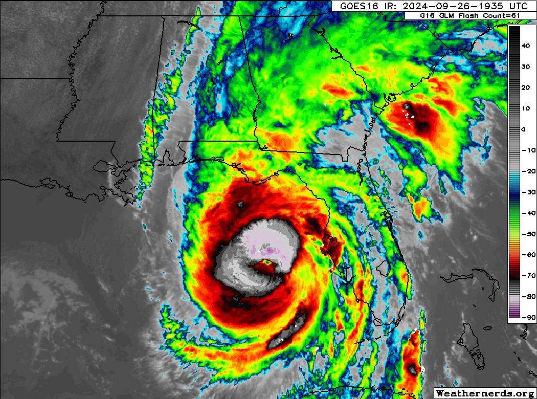
(6:50 PM ET Update): Helene is now a category 4 hurricane with maximum sustained winds of at least 130 mph. Helene is pretty clearing undergoing a rapid intensification cycle at present, and the only question at this point is if it will level off before it makes landfall. The track continues to wobble a bit, perhaps on the right side of the specific track, but in general, the forecast remains steady.
For Tallahassee, it remains really a question of whether it’s really bad or terribly bad. So, neither outcome is great. Looking at satellite imagery this evening, the west side of this thing is no picnic either. Yes, the “dirty” side is living up to its name, but the thunderstorms in the northwest quadrant are going to cause significant wind and rain, and even if this tracks east of Tallahassee, it’s going to be a really bad night.
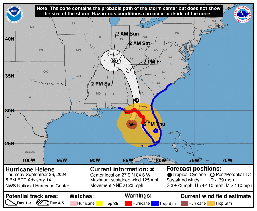
Landfall is expected later this evening, probably close to midnight.
Rainfall will continue to lead to severe flooding well north of where Helene comes ashore. Flood warnings extend in broken fashion from just west of Tallahassee through Atlanta to Charlotte, into far southwest Virginia. Catastrophic flooding remains a strong possibility in the mountains.
Water levels continue to rise on the Florida coast, and the expected catastrophic storm surge north of Tampa through Apalachee Bay will proceed apace in the coming hours. Avoid the coast, do not go see it, it will be deadly. More to come later this evening.
(2:45 PM ET Update): Hurricane Helene is now a 120 mph major hurricane.
(11:25 AM ET Update): The 11 AM ET advisory is out with Helene up to 105 mph. Its structure and organization have improved since earlier. The track forecast has not shifted much in the new advisory, but it’s noteworthy that there have been a few wobbles to the east side of the track forecast.
Wobbles are normal with hurricanes of this size and intensity. The question is whether or not they fundamentally alter the track, particularly at this angle of approach. For most folks in the path of Helene, this has minimal impact on the end result. But for a place like Tallahassee, ending up on the west side of the storm would be immeasurably less impactful than the east side. Still bad to be sure, but not quite as bad as it could be otherwise. This would also impact the western fringe of the surge forecast a bit too. So it’s something to monitor through the day today if you have interests in Tallahassee or along Apalachee Bay.
Whatever the case, nothing has appreciably changed, and a major hurricane is still expected at landfall tonight around Midnight, give or take.
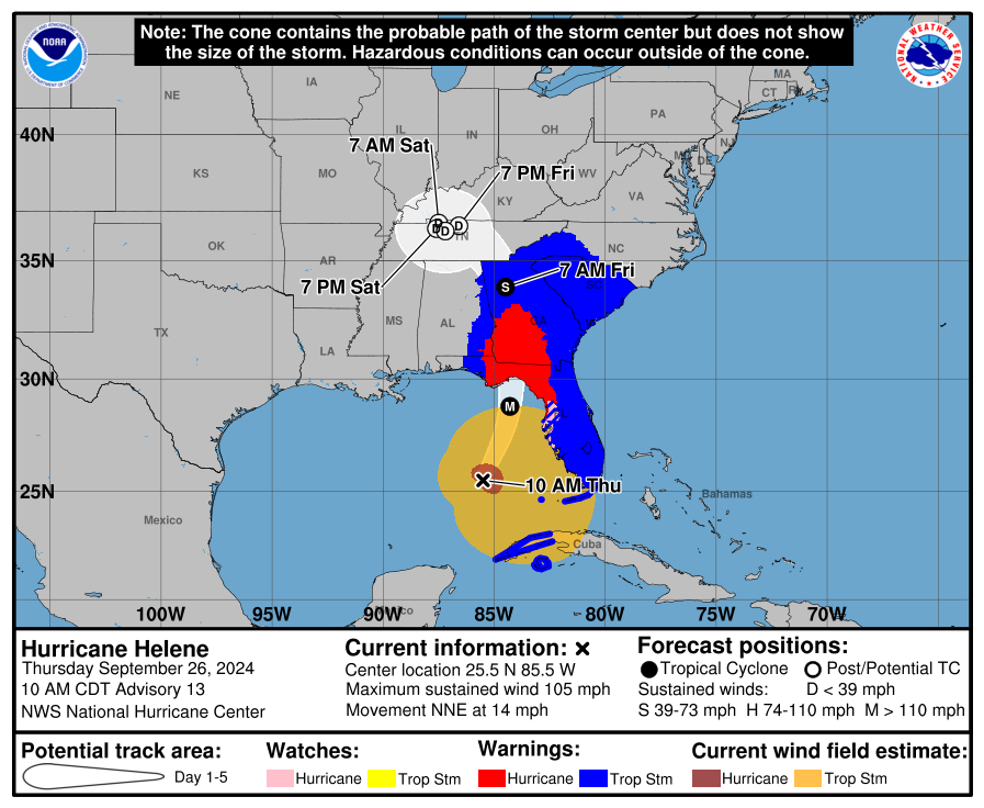
Tropical Storm and Hurricane warnings still extend almost absurdly far inland, but they will almost certainly verify.
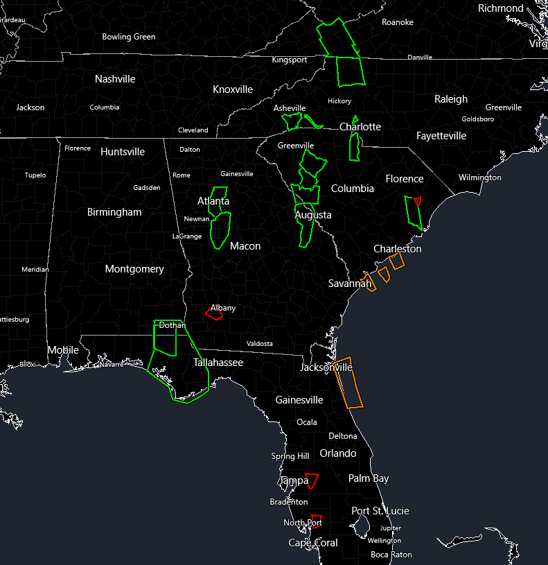
A couple other notes: We already have additional numerous flash flood warnings near Tallahassee, between Macon and Augusta, just north of Greenville, SC, south of Asheville, near Johnson City, TN, and up into Virginia. The inland flooding component will continue to worsen as the day continues.
Tornado warnings have been numerous, and we currently have 3 warnings as I write this in Georgia and South Carolina. This system has the potential to be a prolific tornado producer from Florida into southeast Georgia, South Carolina, and parts of North Carolina. Please ensure you have a way to receive warnings, even if you’re 250 miles from the center of the storm.
Previous post follows…
What’s changed since last night
- No meaningful change to the forecast intensity, track, or impacts into Florida.
- A slight nudge east in the track in North Georgia.
- Helene is now a category 2 storm
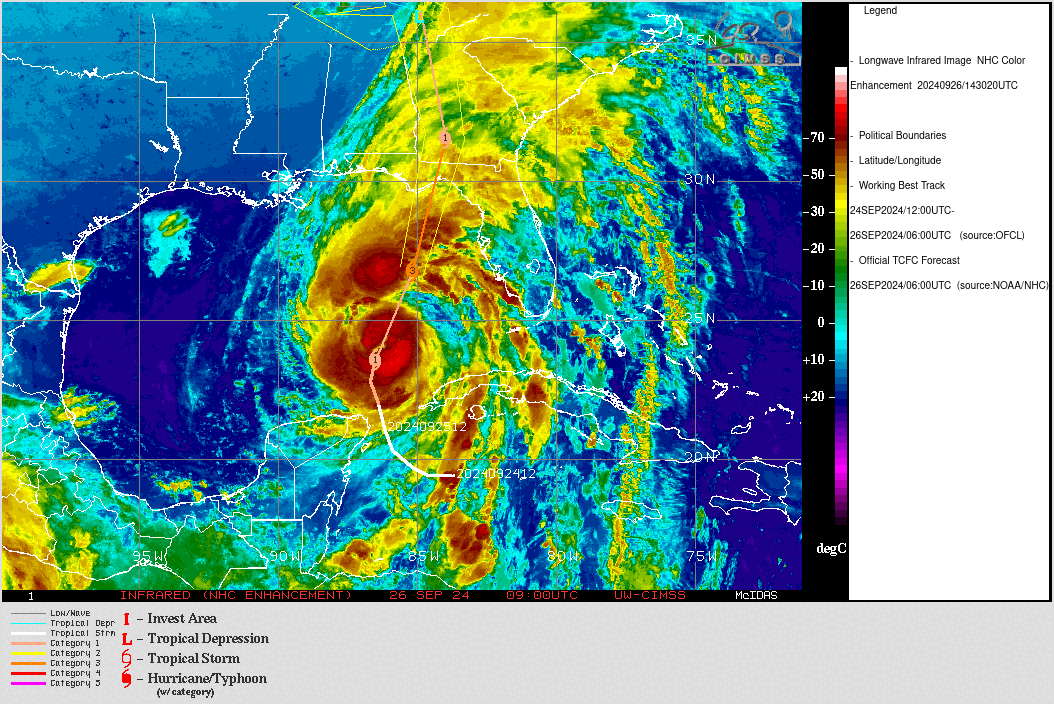
Larger storms tend to be a little more unruly in terms of how they organize. Helene meets that bill today. Reports of “concentric eyewalls” in the storm, almost as if the system is trying to figure out how large it wants to be.
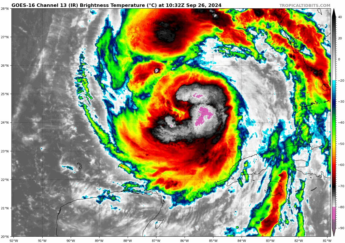
We’ve seen bursts of thunderstorms wax and wane near the center, but we’re currently in an uptick. Recent reports from NOAA flights into Helene suggest surface winds have increased to close to 100 mph. We’ll see what the new advisory shows just after I publish this. (Editor’s note: It has. Now a cat 2 with 100 mph winds). Basically, Helene continues to intensify, and there’s no reason to think the dire forecasts we and everyone else discussed yesterday have changed.
The surge forecast is basically unchanged from last night, with a 15 to 20 foot, unsurvivable peak surge in Apalachee Bay and the Big Bend.
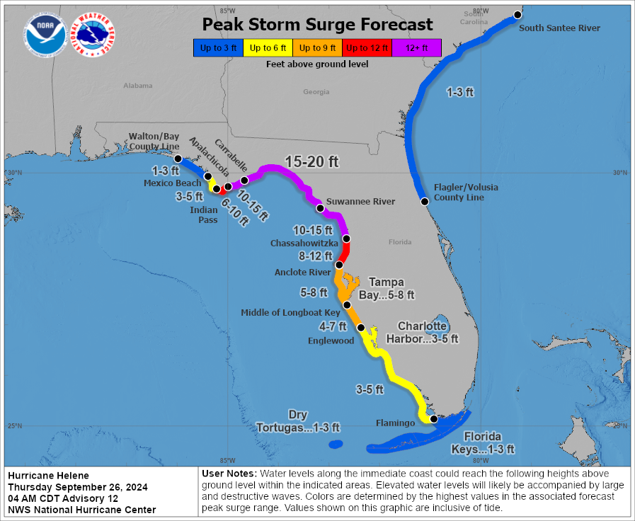
Tampa Bay continues to see a 5 to 8 foot surge, which will be some of the worst surge experienced in modern times there.
The track of Helene is virtually unchanged as well. The most likely landfall point is between Apalachicola and Steinhatchee right now. There remains at least some risk that wobbling of the track could force it closer to Cedar Key in an extreme scenario. I would not rule that out, but I would be absolutely preparing for the worst between Apalachicola and Homosassa and for very bad outcomes south of there to Tampa Bay. Landfall should occur late this evening.
A Tornado Watch is in effect for most of the Florida Peninsula today.
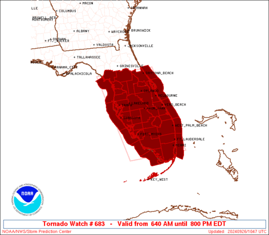
That watch goes til 8 PM ET, and additional watches could be required to the north later today. Isolated tornadoes seem to already be a bit of a threat and this should escalate some through the day and into tonight.
The heavy rainfall threat continues to look very, very bad for both areas near landfall and interior locations in the Appalachians in North Carolina, Upstate South Carolina, and North Georgia.
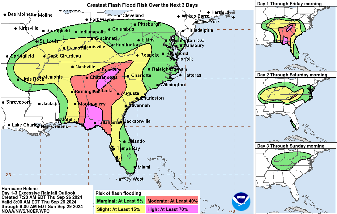
After heavy rain yesterday, we continue to see the risk for 10 to 16 inches of additional rainfall with the storm today, tonight, and early Friday before things slowly ease up a little tomorrow. Catastrophic interior flooding, especially in that high risk area northeast of Atlanta remains a high likelihood.
Real quick tangent here. One of the reasons Helene is going to be such a monster storm as it comes inland is because it’s essentially “phasing” with a massive upper cutoff low over the mid-South. A cutoff low is a storm system in the upper atmosphere that has essentially cut itself off from the jet stream. When this happens, the system tends to just meander around until something changes to kick it out. In this situation, you can see the animation below with the big upper low north of Memphis, and then Helene surging in on the right side of the image.
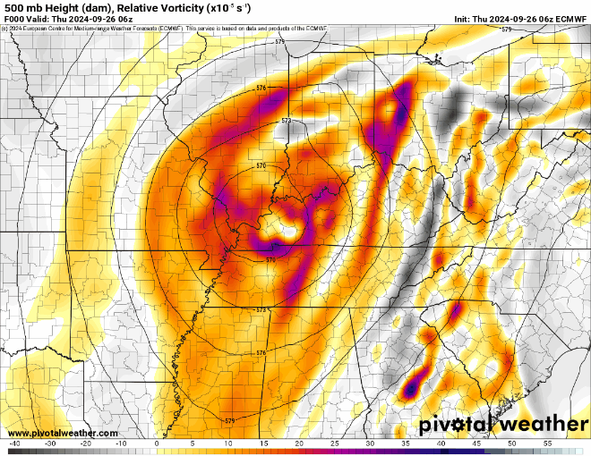
This complex merger is something we don’t usually think of with a hurricane. Hurricane Sandy was a good example of this happening with tropical systems and showed why its winds and size caused so much damage despite “not technically being a hurricane” when it hit New Jersey in 2012. The whole process extends the life cycle of the winds of the hurricane and it’s why tropical storm warnings extend so far inland. The rain element is related as well. With Helene being pulled northeast, then suddenly hooking back northwest “into” the upper low, it will continue to produce rain on the windward side of the Appalachians, leading to additional rain tomorrow and further flooding.
Anyway, that explains some of what’s going on behind the scenes with Helene after it moves inland. We’ll update this post with any notable changes throughout the day.
Any chance you can include timing on your blog updates? I do not see anything about landfall or estimated impact dates/hours….I trust your blog more than the local weather “forecasters”.
So, Helene is merging with another system or will hook into another system and do a weird dance around each other?
It appears that Alabama will be west of landfall. But it looks like it will still feel the effects of the wind and rain. Possible tornadoes? Any chance of the storm tracking further west as it nears the coast? I have loved ones in far SE Alabama and I’m trying to get them all the information that I can.
After living 25 years in coastal/hurricane areas, I read something new yesterday. In all my many hurricanes, I’ve never heard of, the Brown Ocean effect. What is that?
Can you explain to us?
I had to Google it. According to Google: The brown ocean effect is an observed weather phenomenon involving some tropical cyclones after landfall. Normally, hurricanes and tropical storms lose strength when they make landfall, but when the brown ocean effect is in play, tropical cyclones maintain strength or even intensify over land surfaces.
Essentially saturated soils (hence brown) will continue to enable the storm to not weaken as fast as they normally would over dry land.
We had a fading tropical storm that came up the east coast of Florida, just 20 miles or so inshore. It was over enough undeveloped land/wetlands, and close enough to the ocean to intensify over land. It was truly amazing…
I think of them as mud hurricanes – you need latent heat + abundant moisture.
Just wanted to say thanks for your updates here even with the storm outside of the SE Texas viewing area. We have a vacation home in Florida along with plenty of friends so it’s nice to be able to have your local reporting applied all across the Gulf Coast.
Thank you as always for your non-hyped, educational explanation of the weather system. We are in the 10-15” forecast rain area in Western NC. It’s fascinating to understand how Helene will interact with the cut-off low. Even if it won’t be fascinating to live through it… Ya’ll do a great job.
Can you address the GFS model showing another hurricane hitting Tampa Oct 5?
There is little to address with that one yet. Right now, we have to flush Helene out of the system. Then we can start to hone in on what that one may or may not do. Little consistent model signal right now.
I already see a yellow highlighted area between the Yucatán and Caribbean, as per NHC…Not an invest yet..I’m concerned right along with you..
Nobody wants to discuss more than one system (or potential system) at a time….Probably because such discussions can quickly turn into a confusing mess..And the people being hit as we speak in real time, don’t want to feel like yesterday’s news, all while still having to deal with buildings and trees falling down all around them…
Oops, replying to James 🙂
Would it be correct that Houston will likely have higher pressure to protect it, if the new NHC watch area in the Caribbean forms a cyclone in the Gulf?
How hi storm surge can be, and how inland? For Cat 1 storms by NASA I’ve seen 8 feet, 3 ft over a nonfloating dock, 2 feet into 1st floor coneo. But 2 feet won’t flood Houston itself and it didn’t. Ike at 15ft was bad, but most of Houston wasn’t flooded from surge. So, most Houston safe from even awful 15ft surge??? Ike was high Cat 2 but they say had Cat 5 storm surge, 17ft at Bolivar Peninsula… Is Florida Big Bend getting more surge cuz it’s in the Bend, no open ocean to drain the building surge?
And right on schedule a PRE developed poleward of the storm. Causing very heavy rains well north of the eye.
Well, Helene is now a CAT 4. Watching the F O X 24 Hour weather channel (showing live reports) … there’s already extreme flooding in various areas of FL.
Unsettling to know what the FL, GA, TN, and KY folks will have to endure !!
Any way updates could be new posts so I can be notified via email?
What’s happening with the possible thing in the southern Caribbean?