Headlines
- Tropical Storm Debby is slowly intensifying off the west coast of Florida, with about 18 to 24 hours to go before making landfall in the Panhandle or Big Bend area, likely as a strengthening category 1 hurricane.
- Debby will slam on the brakes as it comes inland leading to widespread, potentially historic flooding in coastal Georgia and South Carolina.
- Storm surge with Debby is expected to be serious and fall just under Idalia’s levels in the Big Bend of Florida.
- There are two additional tropical waves we are monitoring for development next week.
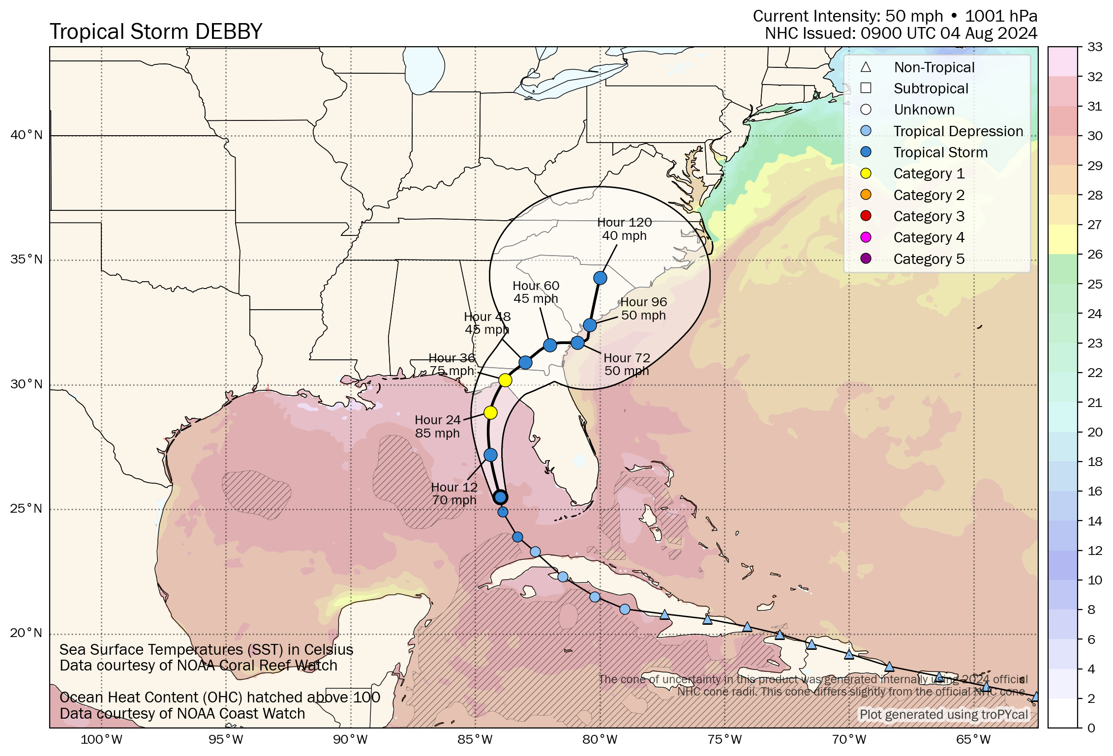
Tropical Storm Debby: 60 mph, NNW 13 mph
Tropical Storm Debby continues to gradually organize off the west coast of Florida this morning, now a more formidable tropical storm.

The bad news is that Debby continues to organize, but I suppose the good news is that it does continue to have some inhibiting factors, chief among it, dry air on the west side of the storm. This will likely be a subtle player in keeping Debby from totally maxing out its intensity potential. That said, Debby is still expected to make landfall in Florida near or just west of the Big Bend as a strengthening category 1 hurricane (similar in some ways to Beryl in Texas last month). This is important for much of that area, and specifically for the Tallahassee metro area in terms of potential widespread power outages. Debby’s exact track will help determine that.
Debby’s storm surge
Starting first with surge, the expectation is that 6 to 10 feet of water could come in along the coast of the Big Bend with Debby’s current track.
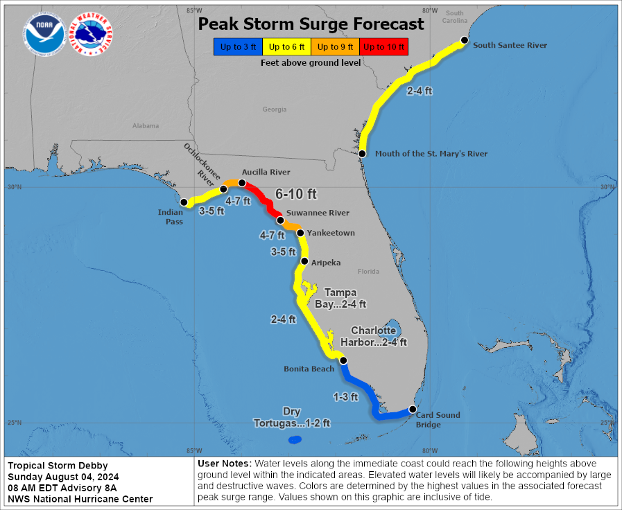
These values are less than were forecast during Hurricane Idalia last summer, but still extremely dangerous. Again, keep in mind that Debby is likely to be strengthening on approach whereas Idalia was weakening on approach. There may be more similarities between the two storms than expected and just because this one is “only” a category 1 storm should not factor into your preparations. Conditions will deteriorate today, so please heed the advice of local officials.
Debby’s track and wind
Debby is expected to come ashore just west of the Big Bend as a strengthening Cat 1 storm. While I noted some dry air above helping to limit Debby’s maximum potential, the biggest limiting factor for Debby may be time. Debby should come ashore in Florida late tonight or early Monday morning, so it has about 18-24 hours left to do whatever it will do.
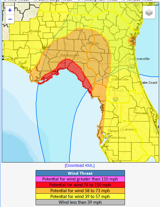
Squalls and bands from Debby will impact Florida’s west coast today, including Tampa with some gusty wind and heavy rain. The worst wind and rain will likely occur from Tallahassee eastward.
Beyond the Big Bend, Debby’s forecast track becomes extremely uncertain. In general, we expect Debby to slam on the brakes and drift northeast, then east-northeast, then, well your guess is as good as ours right now. There are questions as to whether Debby emerges off the East Coast, meanders around so erratically that it ends up back in the Gulf, or perhaps it even just drifts north into eventual oblivion. This leads us to our next issue.
Debby’s potentially historic flooding
Debby is a hurricane first and foremost, and we’re obviously concerned for Florida. That said, the most obvious threat from Debby continues to be flooding rainfall.
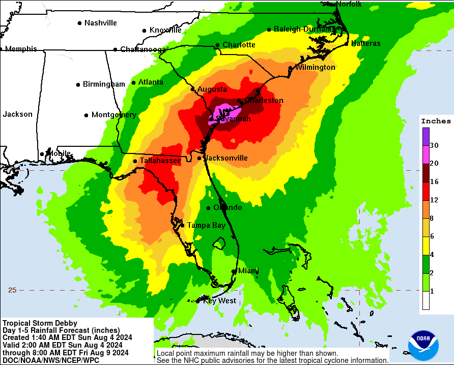
We are now entering some historic territory with Debby’s rainfall forecast. 20 to 30 inches of rain is now expected between Savannah and Charleston, SC, including Hilton Head. This will cause widespread, possibly catastrophic flash flooding, urban flooding, and river flooding in coastal Georgia and South Carolina. The worst will likely be south and east of I-95, but significant flooding concerns will also exist back toward Columbia, SC, Augusta, GA, possibly up toward Myrtle Beach and into southeastern North Carolina as well.
The standing record for rainfall from a tropical system in South Carolina is 23.63″ from Florence in 2018. Joaquin in 2015 aided in over 26″ as well, so we are currently forecasting that rain totals may approach these record levels. For Georgia, the standing record is almost 28″ during 1994’s Tropical Storm Alberto. Whether it’s a record or not, there are unique aspects to this event, including the potential for coastal flooding to exacerbate flooding conditions in places like Savannah, Charleston, Hilton Head, and Myrtle Beach.
I cannot emphasize enough how serious of a flooding threat this is for southeast Georgia and coastal and Lowcountry portions of South Carolina. Please ensure folks in these areas are prepared for this potential.
As always, isolated tornadoes are a possibility as Debby comes ashore.
So, in summary:
- Debby is a historic, potentially catastrophic flooding threat for coastal Georgia and South Carolina.
- Debby will make landfall as a hurricane late tonight or Monday morning near or just west of Florida’s Big Bend.
- Debby will meander for several days, with uncertainty higher than usual on where exactly it ends up.
- Debby will cause damaging storm surge in the Big Bend of Florida, just under Idalia’s levels from last year.
Elsewhere in the tropics
A quick note on the rest of the tropics this morning. We currently have two tropical waves worth watching. One is entering the Caribbean today, while the other sits just off Africa.
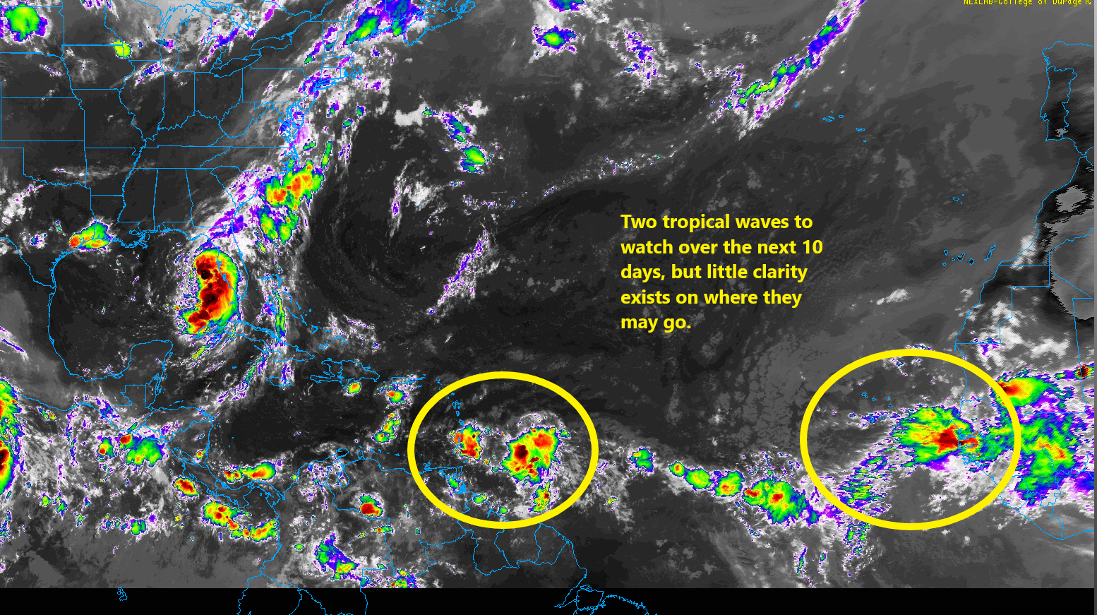
The National Hurricane Center has 20 percent odds for the Caribbean wave to develop as it meanders west. Some modeling does try to allow it to gain some latitude eventually, so I would say we should keep an eye on this one. Same with the one behind it that will be moving into an Atlantic that should be modestly more hospitable for tropical development. We’ll continue to watch. For now, no specific area should be worrying, but it’s now time to check in on the tropics every day or two from now through September or October.
From a weather perspective, what benefits do a hurricane provide? What good do they do? We always talk about damage to property and structures, but what meteorologically do they benefit? Do they cool surface water temperature making a cooler environment?
Excellent question!
They transport heat poleward, that’s why they exist.
They do have a few benefits:
Removing heat from the oceans
In some cases they are drought busters
They decrease salinity in tidal areas
They help take down older weak trees allowing young healthy trees room to grow
They give us a few days off work
If we didn’t have hurricanes we would have something far worse less frequently.
I think you’ve hit on the answer, Pam. We’ve heard meteorologists talk about the tremendous rise in the surface water temperatures. Storms release this buildup and churn mid-level ocean depths, which eventually cool the surface, relatively speaking.
This question is very alien to my worldview. Why do they need to have benefits? They’re a result of conditions in the South Atlantic given the laws of physics and chemistry. Asking what benefits they provide is like, I don’t know, asking what benefit there is to bread going stale. It’s not a matter of “benefit”, it’s just a thing that happens.
This fun Q helps lead to a broader perspective, which increases understanding, which can be applied to many other areas. Transfer of heat. Physics is marvelous.
And it’s cool! ❄
It feels like the NHC odds of development always seem too low.
It’s by design. You aren’t going to come out of the gate with an 80% chance of development and then back down to 30% because something changed. It’s important to lead gradually into things, much like they did with Debby. It retains trust and minimizes whiplash. Critical things.
Thank you. Hey! Don’t underestimate surgery! Take it easy.