Headlines
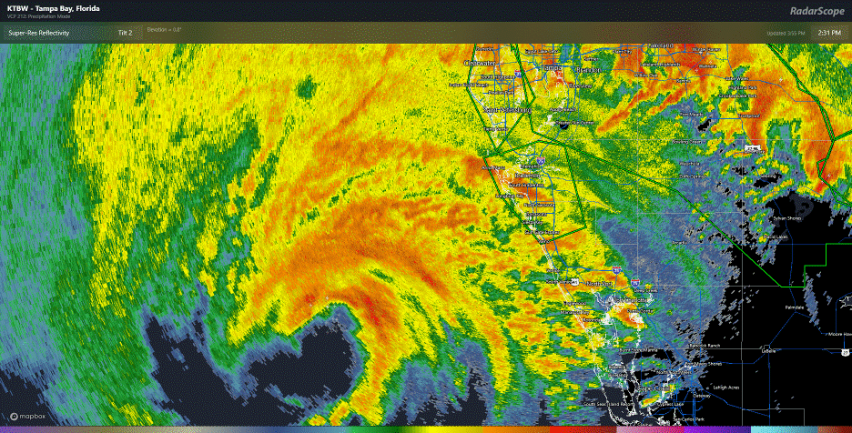
- Milton’s eyewall with powerful winds and a dramatic rise in water from storm surge is about to begin coming ashore between Saint Petersburg and North Venice.
- Tampa Bay may empty out as it approaches (as seen in Irma and Ian), and you should not be anywhere near the bay, as water may come rushing back in quickly and without warning.
- The worst surge will come dangerously close to moving into portions of Tampa Bay south through Venice.
- Significant surge will continue building south of there to Fort Myers and on the east coast as well.
- A historic tornado outbreak has been ongoing across the eastern half of the Florida Peninsula and will continue a bit longer.
- Flooding from another 10 inches of rain is likely in the northern half of the Peninsula.
- Milton exits tomorrow to the east and out to sea.
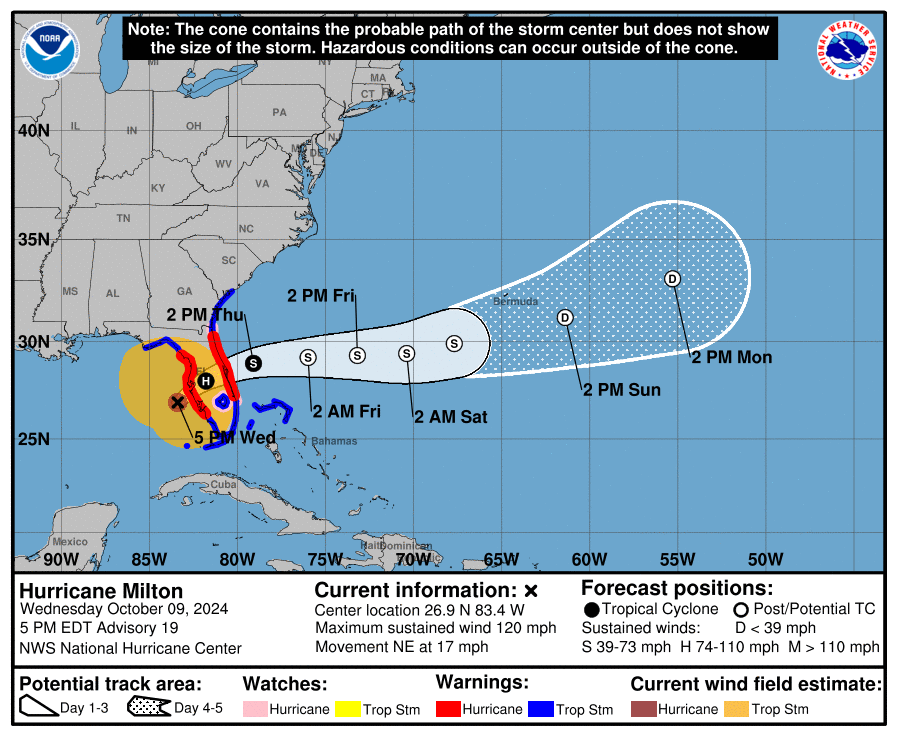
Hurricane Milton is gradually approaching the coast of Florida. It remains an unnervingly close call for Tampa Bay as every wobble makes a difference right now. But it appears the landfall window is between North Venice and Fort De Soto at the entrance to Tampa Bay. The worst of the surge and wind will probably impact the area between Tampa Bay and Venice, with significant surge to the south of there as well. The surge forecast has been adjusted somewhat today.

We still expect significant to borderline catastrophic flooding and inundation in some communities unfortunately. Surge values are currently about 1 to 4 feet on the west coast of Florida. Again, near and south of where this makes landfall will see a dramatic increase in water levels soon as that center approaches.
I can not say this loud enough: If water exits Tampa Bay as we saw with Ian and Irma, do not, I repeat, *do not* go into or near the bay to gawk. This one is coming in much closer to Tampa and it’s possible a wall of water comes rushing back in at some point. You will be trapped.
Milton is not as intense in terms of wind (now a cat 3 with 120 mph winds), but it has essentially doubled in size since this morning with tropical storm force winds extending out as much as 250 miles from the center. Hurricane force winds remain confined mostly to that eyewall that is preparing to come onshore near Sarasota and Bradenton. Conditions will get very, very nasty over the next 2 to 4 hours.
This is the time where you shelter in place and hope for the best. We certainly hope for the best for folks in Florida too.
Milton has been a prolific tornado producer in Florida today.
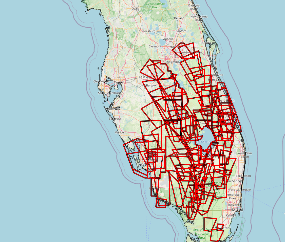
It will take time to weed through the warnings, reports, and damage, but I am certain we will have one of Florida’s most significant tornado outbreaks when all is said and done. Additional tornadoes are possible as the center moves across the state.
Flooding rains continue also, with as much as 2 to 5 inches so far across Florida and a lot more to come.
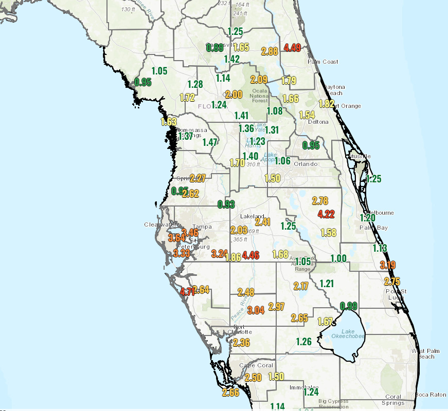
Those rains continue tonight, and we’ll see flooding expand and worsen across the northern half of the Florida Peninsula. As much as another 10 inches or so is possible.
Milton will exit and turn into an extratropical storm (basically akin to a nor’easter or generic “coastal” storm) tomorrow as it rushes out to sea. We can then begin to assess the damage. All the best to our Florida friends, and we’ll have another brief update either mid-evening or in the morning.
New followers, you came to the right place. SCW was truly invaluable when my family was south of Houston during Harvey. So grateful that they’ve expanded coverage and launched the Eyewall. Bookmark them. You will never regret it.
What Julie said 🎯
It sure seems like the hurricane tornadic activity has increased a lot recently. Stronger than the traditional 0s & 1s.
It really depends on the individual storm. We in the central Gulf Coast haven’t really seen any tornadoes from the hurricanes that have come on shore here. This one seems to be spinning off quite a few.
I bet its because the recent hurricanes have had significant dry air get in the circulation around landfall. That was what kept Beryl’s intensity down. But I heard that it increases tornadoes for some reason, which we certainly saw with Beryl.
I’m so glad you haven’t seen them so much 💜
If tomorrow or Friday, you learn of agencies that will help with this pending catastrophe, please advise. Thanks.
Thank you and shout out to Matt and Eric on consistently providing weather updates on storms, hurricanes etc so we can few that info and possible arcs to make the best decisions and choices we can to prepare ourselves, families, homes and businesses to protect them as best we can. I really appreciate the work y’all do and the nonsense communication.
So, I just realized that the consensus model for this storm predicted exactly how this storm would go DAYS OUT. I went through the archives and the first post with an indication of a storm hitting the Tampa Bay metro area was October 3rd. This was before the storm even had a designation. By October 4th and 5th, before it was even named, the consensus opinion was that a tropical disturbance would intensify in the far western Gulf of Mexico and travel across the entire Gulf and strike the Tampa Bay Metro Area. They were also beginning to predict that this storm would rapidly intensify near the Yucatan Peninsula and then that as it approached the coast, dry air and shear would weaken the storm.
Don’t get me wrong, I still think of these things as cones of probability, but the models predicted exactly how this storm would go while it was a tropical disturbance. I think that is very interesting.
They have done very well with both Helene and Milton. However, the original development of Milton was rather unexpected, and as far as I remember it was not until just before the storm had formed that models began showing a strong hurricane.