Headlines
- Tropical Depression 14 has formed this morning in the western Gulf of Mexico.
- It is expected to rapidly intensify late this weekend or early next week into a borderline major hurricane.
- That hurricane will threaten the west coast of Florida somewhere between the Big Bend and southwest Florida.
- Impacts from the storm will be widespread across Florida, with heavy rain and flooding over a wide area, and storm surge risk depending on the exact track of the storm.
- Folks across Florida should begin preparing now for a hurricane impact by later Tuesday or Wednesday.
Just a quick post this morning to lay the landscape out on a number of changes in the last 36 hours. We warned yesterday that odds of development had been increasing in such a way that it was becoming more likely that we’d see something, but even we did not anticipate how quickly things would escalate.
First, we now have Tropical Depression 14 in the western Gulf.
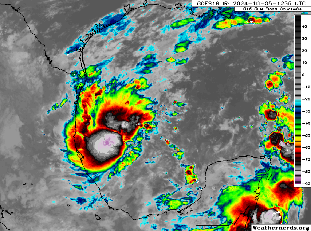
This was not expected to happen so quickly, but that has been the case here today. The National Hurricane Center’s first forecast for to-be Milton is for 110 mph winds and a track to the west coast of Florida.
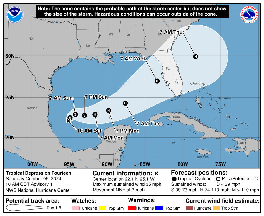
First observation here: Do not focus on the specific track. Focus on the cone. We’ve seen a few instances of west coast of Florida landfalls in recent years, but historically almost none have come from the area where TD 14 is currently. So we’re in a unique scenario here. The geography of Florida is such that a storm into the west coast from this direction will have the worst storm surge on the south side of the storm as it makes landfall. But the worst wind would likely be on the north side. You’re looking at a multi-hazard scenario here. You’re also looking at an extremely vulnerable coastline just a couple weeks removed from Helene. People in Tampa are still cleaning up from surge damage, and now this is on the horizon. People in the Big Bend are still trying to begin recovery as well. While this will likely come ashore south and east of where Helene hit, there will be overlap of significant impacts between the two storms if this continues. Start preparing right now. Maybe this is a fluke or does something we don’t currently expect, but this storm will have an environment favorable for rapid intensification in the Gulf.
In addition to the potential for wind, surge, and marine hazards, the rainfall situation in Florida is quite messy now.
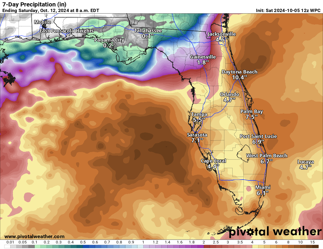
I think the Peninsula is now looking at a widespread 5 to 10 inches. The heaviest rain is shifting around a bit now with organized tropical development entering the picture. While, broadly, the heaviest rain will be south of I-4, there will likely be a corridor of heavy rain near or north of I-4 as well, possibly up into the Jacksonville area. Basically, the entire peninsula needs to prepare for heavy rain and flooding potential. Coastal areas need to prepare for more than that.
I’m going to stop there for now. It’s early in the game, relatively, and I don’t want to speculate too much on specific impacts, but the message is pretty clear today: Start preparing now in Florida for a potential major hurricane hit on the west coast. Eric is going to have another update late this afternoon or evening with the latest, and we’ll be with you into Sunday as well.
Why would the highest winds be on the north side? When traveling eastward, the southern eyewall would be carrying the higher winds with a counter clockwise circulation. Is there something else going on in the atmosphere that would cause the opposite affect?
The GFS was looking bad last night, even more unfriendly this morning. Poor FL 💔
And folks around the greater Houston area complain about our storms. Born in this area 67 years, and currently in the Magnolia area. Years ago considered going to FL, but glad that didn’t happen.
We empathize with what the FL folks are dealing with after Helene (we lost our Cypress property to Harvey). And *NOW* there’s the possibility of yet another hurricane (?!!). Difficult to fathom next steps for them.
Well, the NHC now has a name for DP14 … Milton (which has been predicted will happen), but it sure seems things are happening fast for this storm now, compared to it’s slow evolvement previously.
How is the Atlantic looking between Boston, Bermuda and Aruba starting next Friday? Should us folks from Galveston pack the Transderm Scope patches for a few days in the open ocean?
Thanks.
I own a 2nd home in N Central Fla. Got lucky with Helene. Way more concerned with this one. NOT looking forward to increase in home insurance rates 💰
Being a Houston native, I really feel for the folks in Florida. Not to ask a selfish question, but I am flying into Orlando on Thursday for a long planned family trip to Disney. Three generations with 4 family units all going.
It seems like there’s a chance this moves through by Thursday morning. Or am I just being overly optimistic? Should I make alternative plans?
I would rethink your vacation all together, they are already expecting this to hit as a major hurricane. Have you not seen what a major hurricane like Helene, Katrina, or Andrew has done to such vast areas of the states that they’ve hit. If Milton comes in by the Tampa area, Orlando/Disney areas will be hit hard too. Not to mention residents of Florida will need all the lodging they can get, not to mention the out of state linemen that will be arriving to assist in restoration of the areas.