(11 PM ET update): The 11 PM ET advisory is out with few changes. No forecast changes have been made, and no intensity changes have been made.
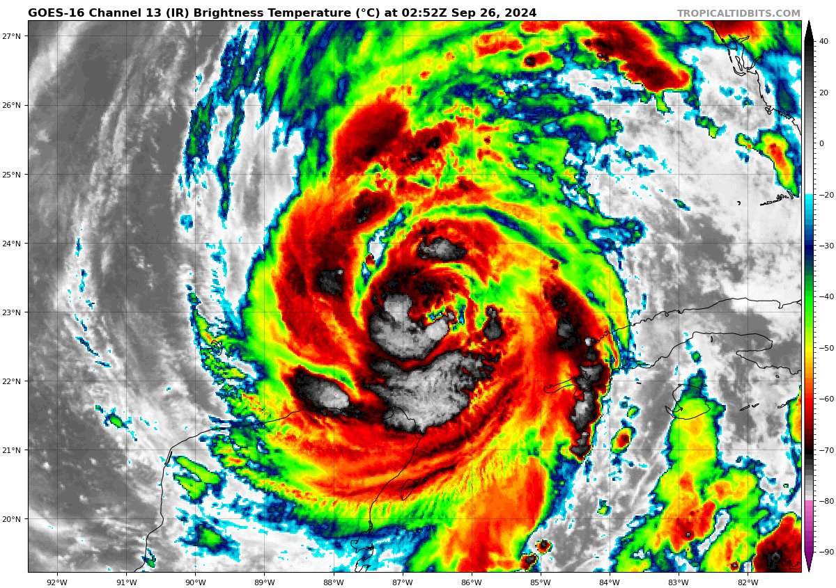
Helene is still organizing, and it seems that the size of Helene is acting to keep that intensification steady for now. As the system hits the ultra warm water in the Gulf and a more favorable environment internally, it will likely strengthen at a steady, faster pace tomorrow before making landfall tomorrow night.
There have been no notable changes to the surge or rainfall forecasts unfortunately. We’ll have an update in the morning.
Previous post follows…
Changes since this morning
- Storm surge forecasts have been increased on the Florida coast with a surge as high as 20 feet expected between Carrabelle and the Suwannee River.
- Helene is expected to be a category 4 storm at landfall.
- The high risk of flooding has been expanded tomorrow in both the Carolinas and in Georgia/Florida.
- Tropical Storm Warnings are now posted for the rest of Georgia, all of South Carolina, and portions of western North Carolina and Tennessee.
- Helene is likely to be the modern storm of record for Florida’s Big Bend Region and possibly some other areas.
This blog is committed to no-hype because of storms like Helene. This one merits your full attention and full preparedness if you are anywhere in the area that will be affected by the storm. This includes all of Florida except the far western Panhandle, all of Georgia, eastern Alabama, almost all of South Carolina, western North Carolina, and Tennessee. We cannot stress this enough. Follow the advice of local officials. This is almost certainly going to be a major storm, and most of the data suggests that this will be a catastrophic storm in several places.
There’s no way we can cover all the elements of this storm, but we’ll try.
Storm surge
The storm surge forecast is, frankly, hideous. The forecast surge values, should they verify, will be worse than any modern storm has brought to the area between Tampa Bay and Apalachee Bay.
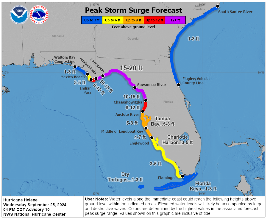
The surge will be worse than Idalia all across the Big Bend Region, Apalachee Bay, the Nature Coast, and Tampa Bay. It will probably be the new benchmark for modern storms in this region. The surge will drop off dramatically to the west of where the center comes ashore, so folks in Panama City and Mexico Beach will only see a minor surge from this, with a huge escalation near and to the east of where the eye comes ashore. If these forecasts verify, this will be unsurvivable type surge in the region east of Carrabelle through about Cedar Key. I cannot stress enough how serious the storm surge from Helene may be.
Wind
Obviously with a cat 4 hurricane expected, there will be catastrophic wind at the immediate coast. But with Helene’s acceleration north, the wind will spread far inland.
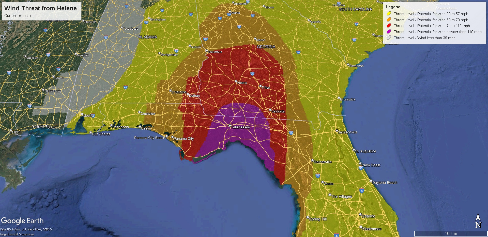
We expect hurricane force winds to get deep into Georgia. The exact track will be critical in determining if Tallahassee sees catastrophic damaging winds or something more manageable. It will be close. It will probably be less close in Valdosta, GA which could see gusts in excess of 100 mph. Those winds will slowly decelerate deeper into Georgia, but hurricane force winds could get as far north as Macon. Strong tropical storm winds will impact metro Atlanta, especially on the south side and perhaps creeping close to Athens. Tropical storm force winds will be an issue deep into South Carolina and western North Carolina, as well as eastern Tennessee. There will be widespread wind damage and widespread, likely significant power disruption. This is a very bad looking storm.
Rain & flooding
We continue to see a high risk of excessive rain leading to flash flooding, possibly catastrophic flash flooding in two areas tomorrow. First is where Helene comes ashore in Florida, which will see substantial rain — what you would expect from a landfalling category 4 storm.
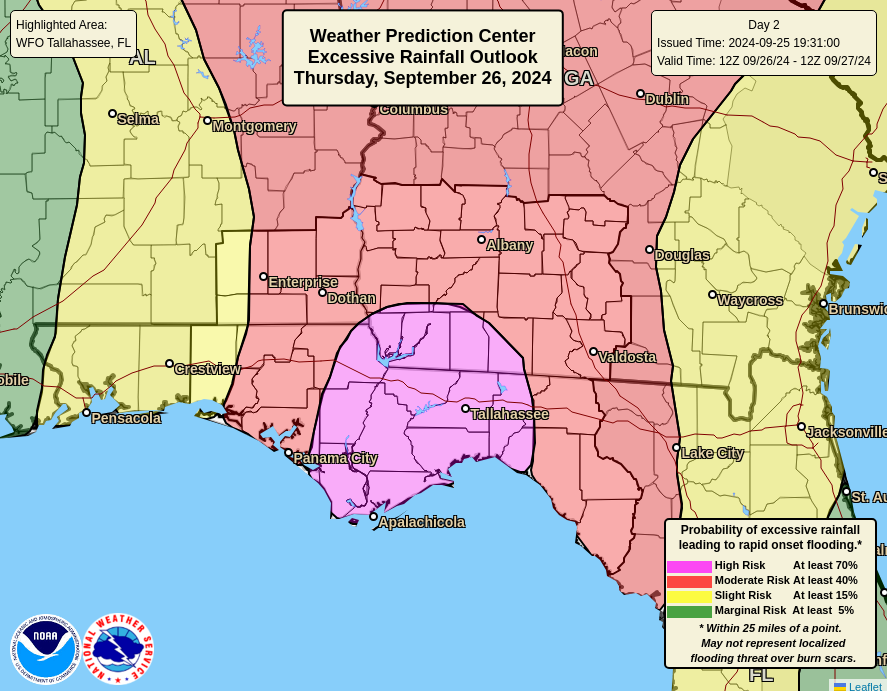
The storm will dump heavy rain and produce widespread flash flooding across Georgia, eastern Alabama and portions of South Carolina as well. But when the storm interacts with the Appalachians, that’s when severe flooding issues could creep up. The high risk was expanded south into metro Atlanta, especially north and east of the city. And it continues through Asheville, NC, including much of Upstate South Carolina north and west of Greenville-Spartanburg. Portions of the Smokeys will also be impacted.
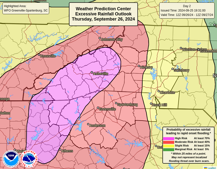
The interaction of terrain with a hurricane can produce copious amounts of rain leading to destructive flooding and landslides, and that’s the concern in Appalachia. Again, I cannot stress enough how serious an event this may be in those areas. It’s a much different hazard than storm surge but extremely dangerous just the same.
Tornadoes
Isolated tornadoes are likely anywhere east of Helene’s center, so be aware of that risk in the Florida Peninsula, the Jacksonville area, and much of eastern Georgia and the Carolinas.
Again, we strongly encourage you to follow local officials, follow local media, and do everything possible to get out of harm’s way. This is not a storm you want to roll the dice on. We’ll update this post later this evening with any relevant new info. Look for a full post again in the morning.
Ugh
So sad to read this.
Hope people listen and get to a safe place.
Because of your no-hype stance, it’s always very sobering when you start discussing serious storm impacts of this magnitude. I wish the best for everyone in the path of this storm.
I feel exactly the same. If the SCW guys are warning of a serious storm, I would be leaving the area. Keeping all of these people in prayers throughout the night and in the days ahead.
Same…..so grateful.
My brother and his family live in Jacksonville. So nervous for them. I just went through Beryl in Houston and can’t imagine what Floridas about to experience. I was here during Harvey, Rita Ike and some others. Praying for my brother and all effected by this hurricane. 😩🙏🏼
I hope those inland people don’t underestimate what 60mph winds can do.
I hope the roads are not jammed but where do people from that huge area go to get out of the way? A little too Gaza-esque for me.
Godspeed to all those in the target area.
Thanks so much for the information. We are in Valley Alabama, about 20 minutes southeast of Auburn/Opelika on the Alabama / Georgia boarder. We live on the shore of Lake Harding, a 6000 acre reservoir on the chattahoochee river, and thus take potential flood events seriously.
As a Houstonian I really feel for everyone about to be impacted by Helene. This storm is going to be one for the books.
Hey! Houstonian here living just north of Valdosta GA. I appreciated you through Harvey and other storms prior when I was living in Texas. Born and raised. So, THANK YOU for covering this storm. I came here specifically to see if you had. We are taking your words to heart.
Y’all take care! Take all the precautions you can and help your neighbors who dont know how. We just went through a terrible cat 1 Beryl; you know the drill! Kessings!
Thank you for this helpful information. I’m East of Atlanta, so I’m bringing in the lawn furniture and moving the car to higher ground!
Thank you! I echo the others ..I read the first line of this annd immediately called my college student and made her put me on speaker with her roommates in Georgia to read the rest to them. I know all to well when you guys are this worried it’s damn serious (Houston Harvey survivor)
Praying for all those in the way of this one. Helene is looking to be a really big and powerful one. I hope people take her seriously.
-One stressed out Mama with a kiddo on the dirty side 😬
This is indeed sobering, and we are holding all the folks in the affected area in our thoughts and best wishes. Wondering about a science question if anyone (not Eric or Matt, who are busy) can answer: why does the interaction of terrain with a hurricane produce copious amounts of rain?
JLW: It’s because of the additional lift on the windward side of a mountain. That additional lift is minimal or not present over flatter terrain. Moisture laden air rising up the windward side will cool even more and the higher it goes, the more moisture is squeezed out of it. It’s called the orographic effect.
Thank you!
Feel so much for the people going through the stress of this storm – before/during/after, all of it. All thoughts to their safety and well being.
Great information, but did I miss it or did you not state “when” this is happening? As in when will landfall occur? Looking for timing is all, but great information you guys post.
JRB: According to the latest NHC map, somewhere around 7pm Thursday, give or take.
Since the National Hurricane Center is based in Miami, that probably or may be Eastern time.
I am praying for all of the people affected…
When Ike happened, our younger son’s friend lost his home…He stayed with us for a month until he could get his bearings…
When Katrina happened, so many people were displaced…Some of the finest nurses I worked alongside with were Katrina evacuees…
I began my journey with you over 5 years ago as a Space City Weather reader working around the Houston area. I can honestly attest to your drama free forecasting. On the rare occasions you have escalated warnings, it’s been spot on. Anyone reading these warnings needs to understand, it’s not hype. Thanks to Eric and Matt for creating The Eyewall.