Headlines
- Disorganized showers and storms over the Gulf will become a disturbance this weekend. It will likely track east toward Florida.
- The current thinking is that it will have a low ceiling of intensity, but it may be a significant rain maker, especially on the coast (both west and east coast of Florida).
- Hurricane Kirk should become a category 4 storm over the next couple days in the open Atlantic, no threat to land.
- Tropical Depression 13 has formed behind Kirk and should become Leslie, also no threat to land.
Gulf potential still there
We continue to monitor the chances of Gulf development. Although the NHC maintains a 40 percent chance this morning, I suspect that may be slowly increasing again. If we look at satellite imagery, we see two disorganized disturbances right now; one in the Bay of Campeche and another in the northwest Caribbean.
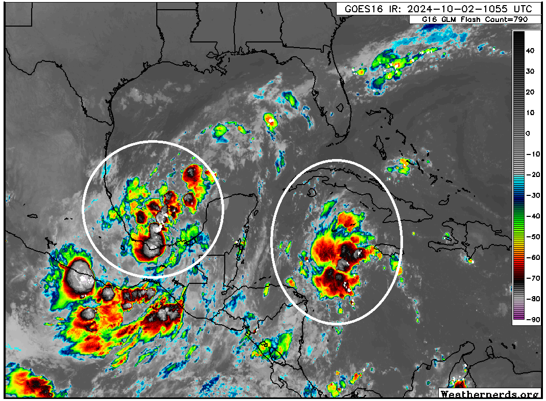
The overall environment is somewhat favorable for development, but there’s just no order to any of this right now, so any sort of organization would proceed slowly. Over the next couple days, we’ll likely see this lift north and sort of merge in the Gulf, becoming one disorganized disturbance near or north of the Yucatan. By the time we get to Sunday, we should have an invest or some sort of surface low pressure system in the central Gulf of Mexico.
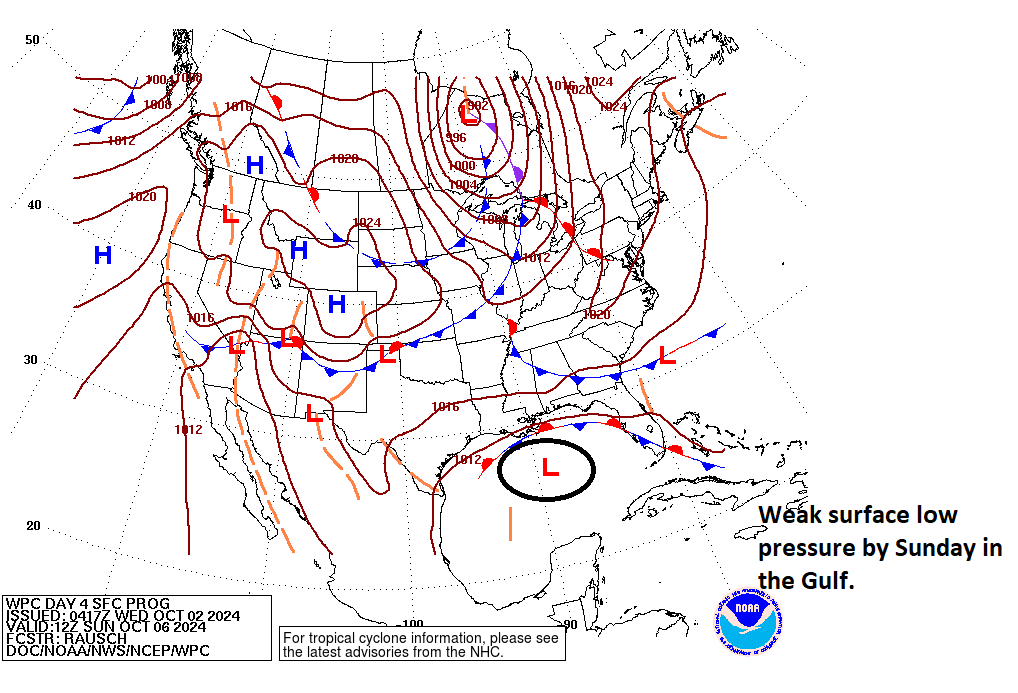
This will sit there while a weak front in the Southeast and a slightly more robust front in the Plains and Mid-South drop southward toward the Gulf on Monday and Tuesday. What this means is that whatever this becomes will likely get pushed eastward toward Florida. Unlike Helene which came northward, this one seems more likely to have an easterly bend in its track toward the Peninsula. By Tuesday morning, we likely have some sort of system, be it still an invest or perhaps a tropical depression sitting just off the west coast of Florida.
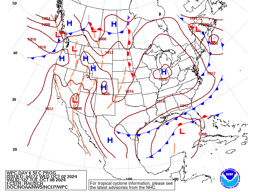
Based on most modeling, there is decent growing agreement in some sort of weak low moving into the Florida Peninsula on Wednesday or so. I don’t expect this to be a hurricane right now, but a tropical storm is a possibility, and this will certainly carry a good deal of rain across Florida as well. Expect marine impacts, rip currents, and breezy conditions next week if you’re visiting Florida. Rain totals are pretty steady day over day, though isolated higher amounts closer to 10 inches will be possible on either the Gulf Coast or East Coast of Florida next week.
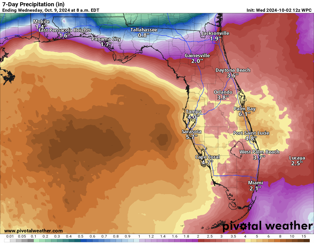
So, at this point in Florida, you’re probably looking at a swimming and marine hazard risk, along with the potential for flash flooding from rainfall, especially on the coast. Obviously the West Coast does not need to hear more about any flooding, but it’s a possibility to monitor. Surge impacts would probably be light to moderate from this. Obviously if this can find a way to intensify further, we’re looking at a different outcome. At present, modeling is in good agreement on the scenario outlined above being the likely one. But as always continue to monitor forecasts for any changes.
Atlantic twins ahead
Hurricane Kirk is now expected to become a category 4 storm in the next couple of days as it wanders over the open Atlantic.
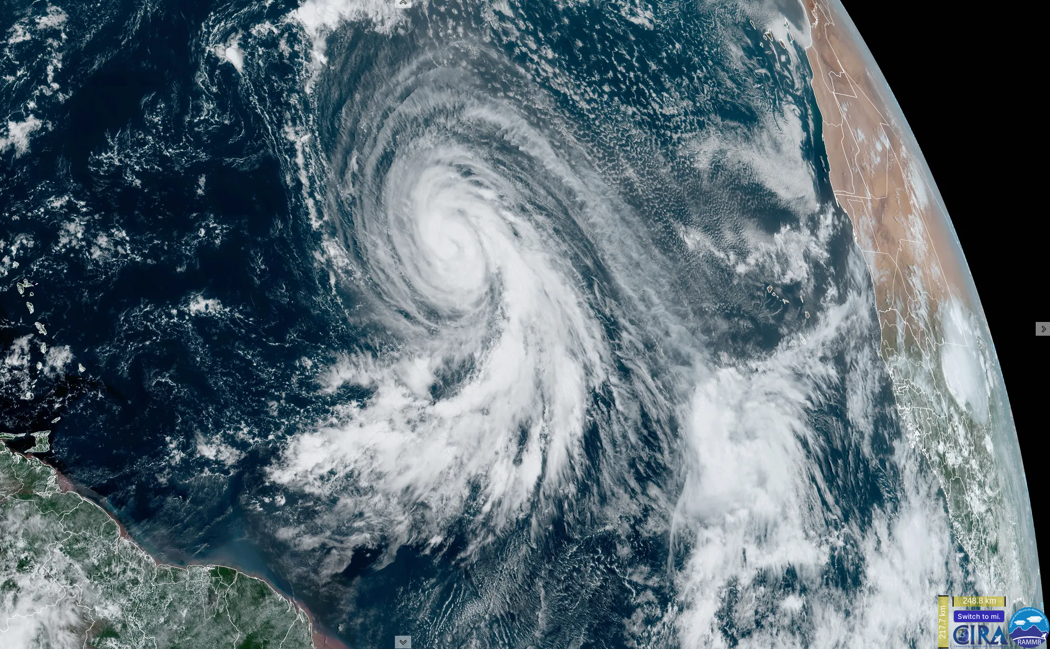
Kirk should go beast mode out in the open Atlantic the next couple days, while TD 13 slowly gathers steam. Modeling is a bit less aggressive with 13, but we should at least see Tropical Storm and eventually Hurricane Leslie form. It, too, is expected to remain out at sea, not far from Kirk. Neither are threats to land.
Behind these two, there are no signs of any meaningful disturbances at this time. Hopefully we can enter a period of calm in mid-October, but we’ll see if anything else shows itself in the days ahead.
Thank y’all for keeping us in the know.👍I appreciate y’all.
Matt, in your view, were the early dire forecasts about this year possibly being the “worst hurricane season ever” in terms of both storm intensity and the number of named storms, off the mark? I realize we have had three hurricanes (Beryl, Francine, and Helene) strike the Gulf Coast this year, with Helene being the worst by far, but I don’t think that is so unusual. Did forecasters fail to take into account how wind shear, Saharan dust, dry air, and jet stream location might discourage storm development despite record high ocean temperatures? Did we just get lucky, or could these “other factors” have been predicted?
This will merit a lot of postseason thought, but my initial thought is that we got lucky. And it was by things that could not really have been foreseen at any degree of seasonal scale predictability. I’ve told people that if faced with the same variables, I would absolutely push out basically the same forecast. Mine was a little more restrained than some others, but that’s just my M.O. The biggest change that I think deserves a lot of focus is on communicating the risk. “Yes, it could be a very bad season…but” We tried to do that with a post about how the season could fail. But I think that concept needs to be adopted more broadly. I also think less emphasis should be placed on the seasonal forecast and more placed on preparedness. But that’s just my early MMQB of things.
I like it that you guys urge preparedness but don’t overstate the threat. If the guys at Colorado State and other forecasters are thought to have cried wolf too often, the public will be less inclined to listen to them when a real catastrophe is on the horizon.
Always in motion, the climate is.
I hope I have enough adaptability left in me.
Thank you for teaching us about weather patterns, and hurricanes, and for keeping us up to date…
I also enjoy reading the comments section…
I like reading other’s thoughts about hurricane preparedness, the livability of this region, where/how to help those affected by hurricanes…
I’ll be arriving in Miami for a conference on Monday and scheduled to leave on Thursday. Do you see any major impact to Miami from this new storm?
I was looking at an article published May 3 entitled “2024 Atlantic Hurricane Season Outlook: Above average season brewing?”, by Aaron Burton. He outlines factors including high water temperatures, high precipitation, lower wind shear and something called accumulated cyclone energy. He makes a convincing case for an above average season. Yet he, and many others, were wrong. I think Matt’s comments above are sound. It was wise for forecasters to give the warnings which they did. And we can be thankful we were spared the measure of destruction visited upon the southeast.
Is there any chance that Kirk and 13/Leslie Fujiwhara and merge together?