Headlines
- Tropical development potential is increasing in the Gulf again, as moisture Sunday-Monday may precede an organized system next week.
- It’s too soon to say exactly what may occur, but model agreement in something has increased rather significantly since yesterday.
- Interests in Florida should prepare for heavy rain and flooding in the I-4 corridor and on the coast, and may need to begin to prepare for an eventual tropical system next week. Stay tuned this weekend.
- Kirk is near or just past peak intensity now and Leslie is on the increase out in the open Atlantic, no threat to land.
Something may emerge from the Gulf sloppiness
We continue to watch with curiosity how exactly the Gulf situation will unfold. What we know for sure: A multi-day rain event is coming for the Florida Peninsula. What we don’t know? Just about everything else. Modeling seems to actually be reinvigorating the potential for some sort of formal development of this system in the Gulf. If we look at satellite today, we can at least see the early underpinnings of it, courtesy of the remnants of Pacific Tropical Depression 11.

The system sits just off the coast of Mexico in the Bay of Campeche. Almost all operational models now show at least some organization of this system by Sunday afternoon just northwest of the Yucatan. As it moves east northeast, it continues to develop on most modeling as well. We actually have a majority of Euro ensemble members showing some development by early Tuesday morning.

Beyond this point, modeling seems to diverge. Some kill it off as just a rainstorm. Others keep it going and developing as a higher end tropical storm into Florida. I think there’s still plenty of uncertainty, but if we were close to writing this off yesterday, we need to take the concept of tropical development seriously today.
Aside from that, the potential for heavy rain and flooding both ahead of and with any tropical development is legitimate in the Florida Peninsula, primarily near or south of I-4. One wave should arrive Sunday into Monday, and then the next would arrive later Tuesday into Wednesday depending on how this evolves. Each wave will bring the potential for heavy rain, with a gradually increasing flood potential for Florida.
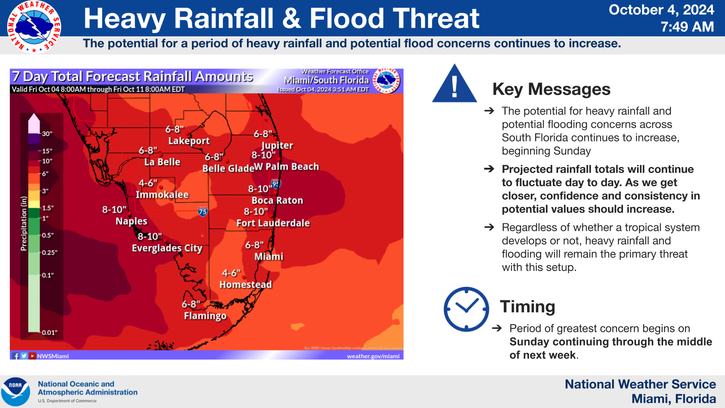
Rain totals are still around 4 to 8 inches on average, especially on the coast and along the I-4 corridor, but some other inland locations will also have potential for heavy rain and flooding too. This will be a situation to follow closely this weekend in case of any sudden change in development chances.
Kirk flirts with Cat 5, Leslie ramping up
Hurricane Kirk blew up last night into a category 4 storm, and at times some of the remote sensing data we use to estimate intensity of storms that far from land indicated it was on the precipice of category 5 intensity. It still looks textbook today, again no threat to land thankfully.

Kirk has maximum sustained winds of 140 mph, and a slow weakening trend should begin this weekend. By next week, Kirk will be a distant memory.
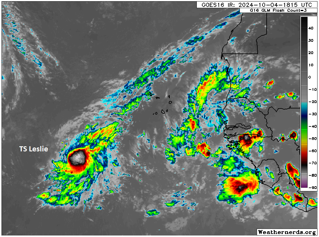
Meanwhile, to Kirk’s southeast, Leslie is taking on some strength of its own. Now a 65 mph tropical storm, Leslie is expected to become a hurricane this weekend, possibly close to a major hurricane. It has a few more hurdles than Kirk had, including Kirk itself. But I suspect it’ll be a healthy storm soon.
Beyond these two storms and a potential one in the Gulf, we have nothing else to really speculate on right now.
The modeling is starting to look unpleasant. It looks like two things wanting to spin off.
How do they get the wind speeds for Kirk and Leslie? Are they flying “Hurricane hunter” planes out that far to get measurements?
I think they use satellites?
It’s a good question. If they can use satellites, then why would they make the poor hurricane hunters use those old rusty buckets? 🤔
Those “old rusty buckets” have been helping noaa provide valuable data to share with public for storm preparation.