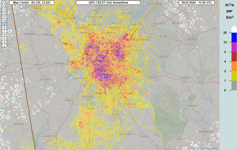
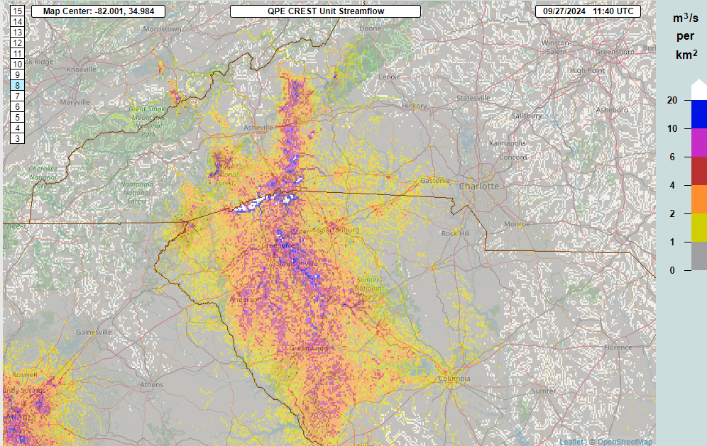
Ex-Hurricane, now Tropical Storm Helene is causing a historic flood event this morning all across the Southeast. I count no less than 10 flash flood emergencies as I write this between Georgia and the Carolinas. These include Atlanta, Charlotte, and Asheville.
I don’t recall the last time I saw 10 flash flood emergencies at once. Suffice to say it can probably be counted on one hand or less.
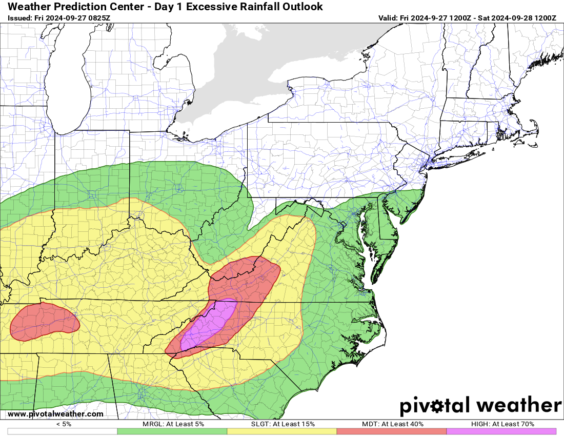
A “high” risk (level 4/4) for flooding remains in effect today in western North Carolina. It’s surrounded by a moderate risk. all the way into extreme southern West Virginia. A second area of moderate risk exists just west of Nashville. High risks correlate strongly to the worst flooding outcomes in terms of damage and loss of life, so much like yesterday and overnight, this will be a rough stretch.
Conditions should improve in Atlanta today, but the damage is done. Asheville remains at risk, as do locations up through Roanoke through Virginia.
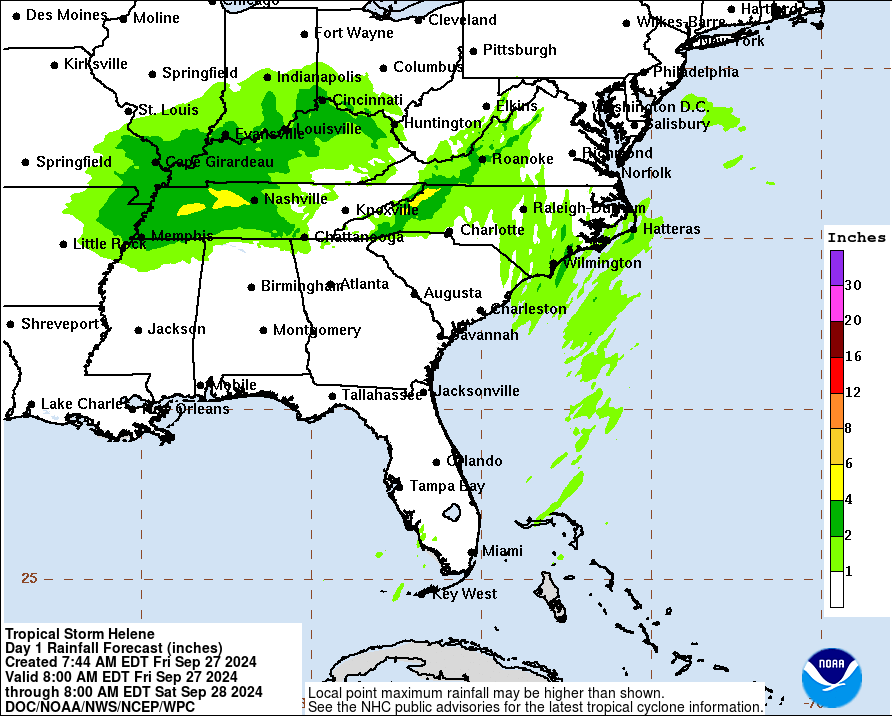
Meanwhile, winds continue gusting in excess of 50 and 60 mph all across South Carolina with even some 70 mph gusts too in North Carolina. Power outages are up to about 3.5 million between Florida and Virginia. Those numbers may continue to increase a bit more. The hope is that the low pressure center of Helene will slowly lose identity and weaken by later today and tonight. Flooding risks should drop off heading into tomorrow, though isolated flooding will be possible north and west of the hardest hit areas, perhaps into southern Indiana or Kentucky.
I have not had time to dig through reports from the Florida coast, but I know that it will take time for the worst surge reports to emerge. It always does. And we will almost certainly see the NHC forecasts of 15 to 20 feet verify. The Tampa area broke all their surge records yesterday by a wide margin. This was far and away the worst modern storm to hit the northern west coast and Big Bend area of Florida. More on this to come.
Other news and notes
We’ve neglected other things this week for obvious reasons. Here’s just a quick rundown of what else is happening. More to come on this.
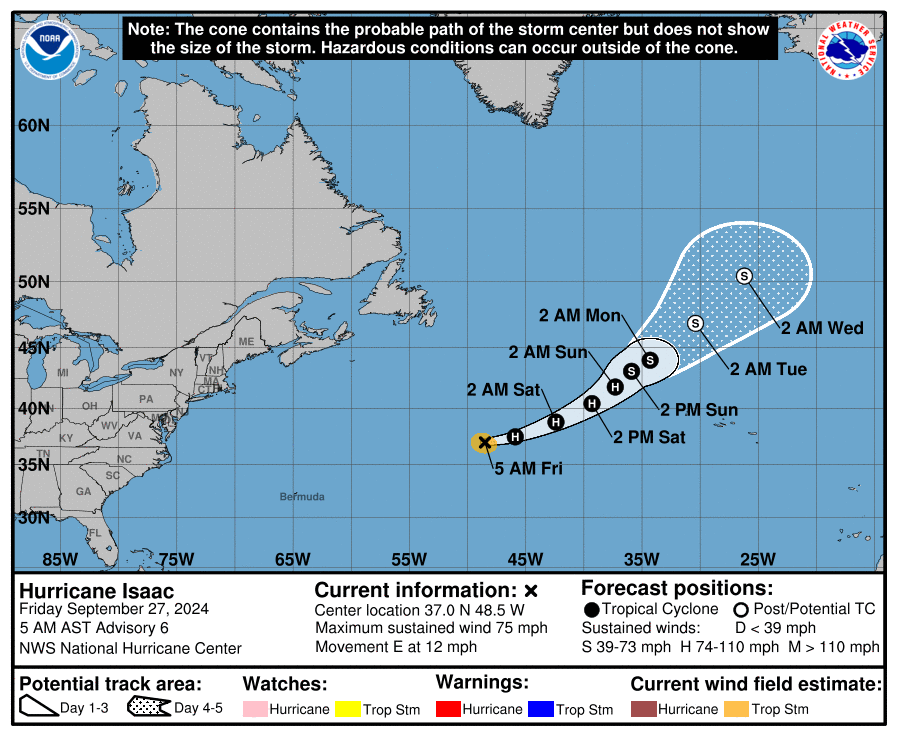
- Tropical Storm Isaac formed and was upgraded to a hurricane today. It is headed out to sea.
- Invest 98L, also in the deep, open Atlantic has a good chance to be upgraded to a depression or Tropical Storm Joyce later today. It is no threat to land.

- The NHC dropped an area of interest yesterday in the Caribbean in a very similar spot to where Helene was conceived. It has a 30% chance of developing over the next week.
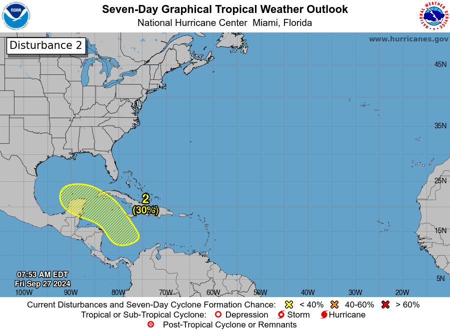
- This Caribbean or Yucatan area does not currently have the same degree of model support we saw at this point from Helene for something high-end. However, there is a substantial signal for something in the region next week. We’ll have more on this later in the weekend. For now, don’t worry about it but check back in for updates.
We will post again later today with an update on Helene and anything else of note.
SCW reported “there’s no real indication an organized system is ultimately going to track toward the Texas coast”
Question. Is this just because the models are unreliable that far in the future? Or is there something else at work that gives Texas an advantage?
Time of year certainly helps. We’ll have fronts in the area around that time, so one would expect it to go more east than west.
It seems the EPS ensemble members are showing a front pushing it’s members east.
East….. is there any atmospheric magic that will spare New Orleans? Helene – type storm here would be unthinkable. Which is horrible to say bec that means it could cause problems for someone else. Thank you and the other meteorologists who have so much integrity. Many of us rely on you!
Lake Lure Dam in Rutherford County near Black Mountain, about 45 minutes SE of Asheville, is in imminent danger of failure. They are evacuating people below the dam.
Have a bunch of friends in the mountains of North Carolina who are getting absolutely hammered by Helene this morning. Expecting anywhere from 12 to 15 inches of rain. One text said, “Trees coming down in woods sound like cannon going off.” To say they are not accustomed to such weather is an understatement.
This whole episode has me thinking “what if Helene hit Houston”? A similar storm will hit here eventually. Do I want to be living here when it does – especially as an almost retired person whose nearest relative is nearly a thousand miles away? Not really.
Most of the problems related to living in Harris County/Houston can be resolved by moving to Montgomery or Fort Bend, which aren’t in nearly the same state of long-term decline as Harris County. But there still remains the problems of summer and hurricanes.
So Helene – along with Beryl – has pretty much sealed things for me.
Fort Bend is tough, but maintains itself well. Good engineering and accountability.
Harris, well, you know. Trying but falling apart.
Outside of the immediate Woodlands, Montgomery is not well regulated. Lots of code violations and little enforcement, illegal sewage dumping and lots of flooding. Just check out all the rentention ponds north of 99. Swampy.
Well, it would definitely be the Woodlands there.
11:45 a.m.
Mayor of Tallahassee on TV just now:
We began restoration once storm passed (~2a.m.).
1/3 of those out, have had power restored.
All of Houston: Restoration Envy