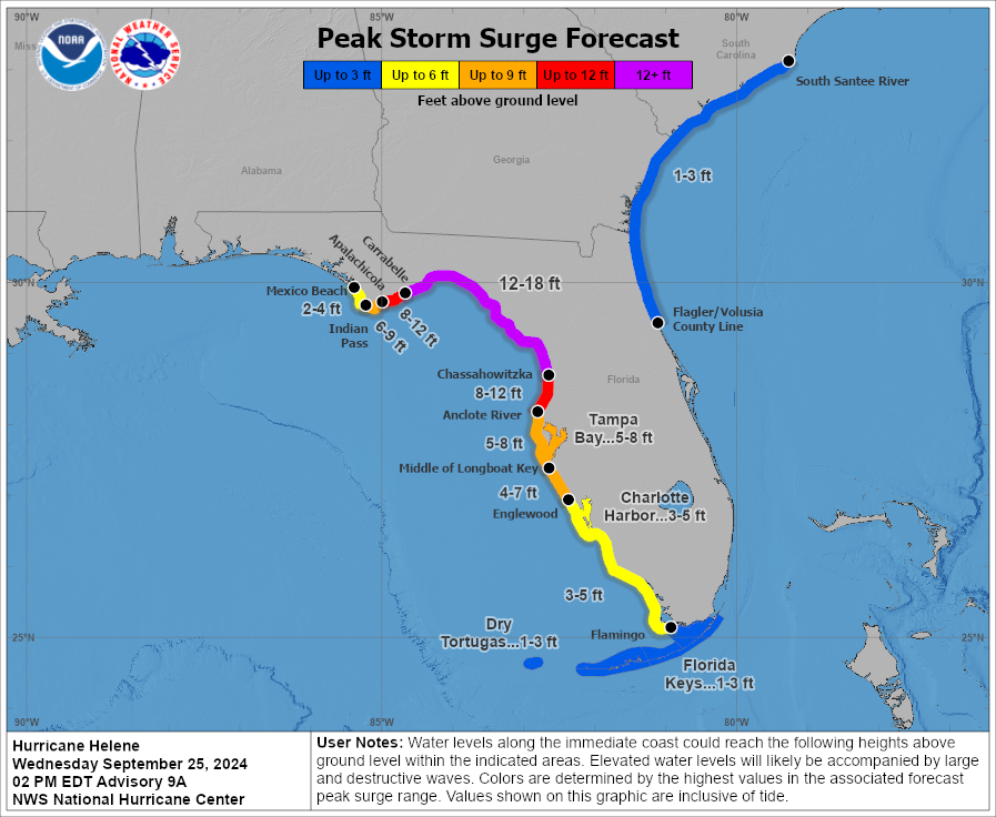
(2:25 PM ET Update): The storm surge forecast has been increased to 12 to 18 feet in the Big Bend, now well above the levels set during Idalia last year. This has potential to be the benchmark event for this region historically.
(1:20 ET Update): Hurricane Helene is here, as it has strengthened enough to cross the threshold to hurricane intensity. Winds are 80 mph, and strengthening into a borderline Category 3 or 4 hurricane is expected up to landfall tomorrow night.
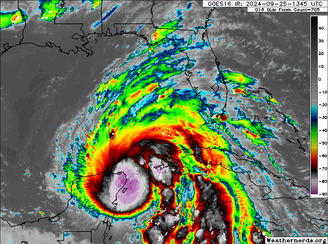
Helene will rapidly intensify into a major hurricane tonight or tomorrow. SHIPS model guidance shows a 10 times greater than normal chance of Helene adding 50 mph to its intensity over the next 36 hours, which would place the storm on the cusp of category 4 intensity.
Whatever it becomes at this point may matter little, as the impacts now seem set: Catastrophic storm surge, worse than Idalia for the Big Bend and Nature Coast, severe storm surge in Tampa Bay, significant wind damage from the Big Bend and Panhandle deep into Georgia, and potentially catastrophic flooding in North Georgia and the Carolinas. Among other impacts. For the U.S., Helene appears to be the most significant threat of the 2024 hurricane season.
The surge forecast has changed little from this morning, though the 10 to 15 foot values were nudged a bit west to Carrabelle, FL. Again, this is likely to be much worse than Idalia and over a larger area.
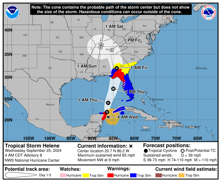
The landfall forecast continues to hold steady. Expected landfall is in or very near Apalachee Bay.
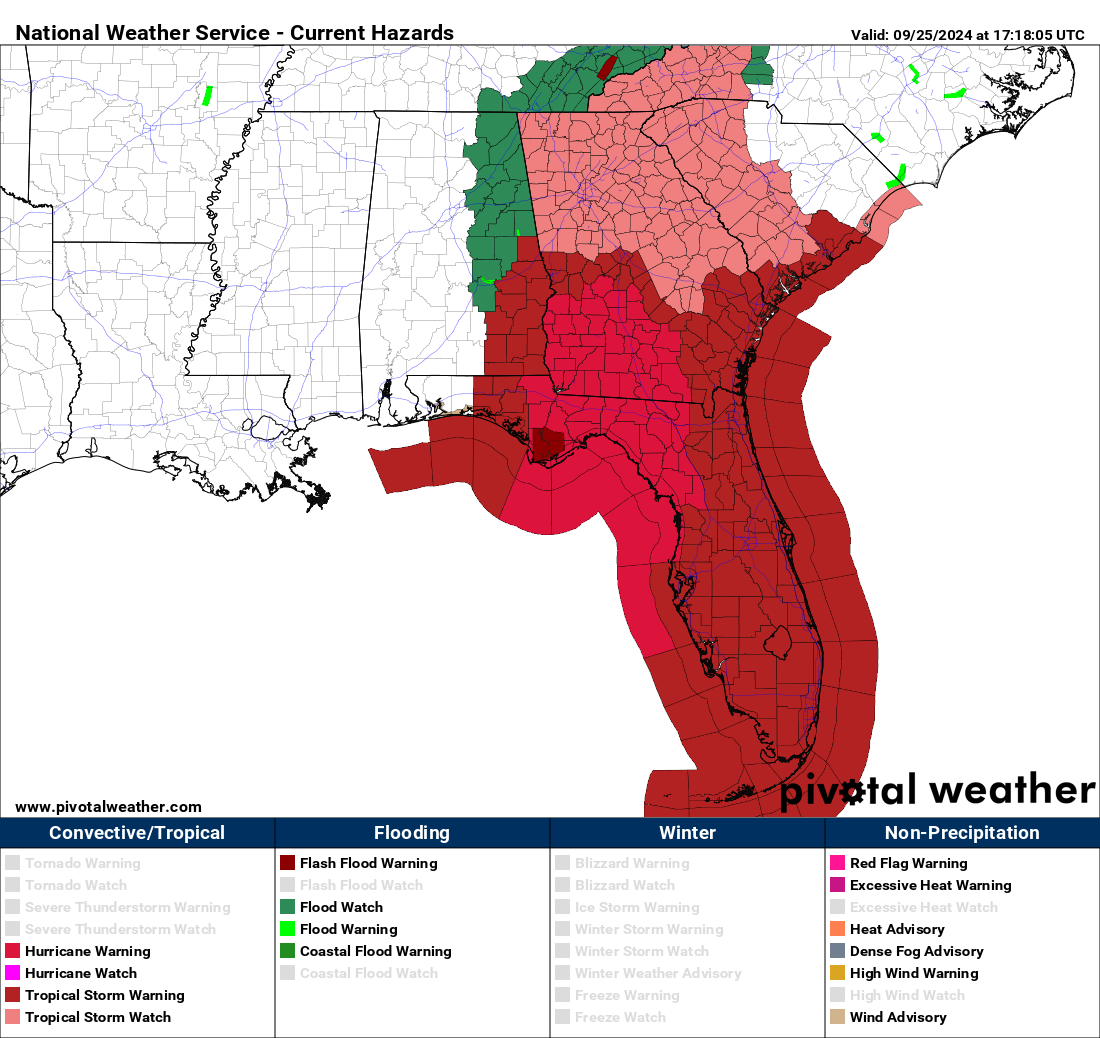
Inland tropical storm watches and warnings have been expanded today and now cover parts of Alabama, all of Georgia, much of South Carolina, and western North Carolina.
We continue to watch the rainfall outlook very closely. Unfortunately, many areas will be drenched today by a predecessor rain event (PRE) that will exacerbate flooding as Helene itself comes inland tomorrow night. As much as 2 to 5 inches of rain are expected today and tonight across Georgia and into North Carolina.
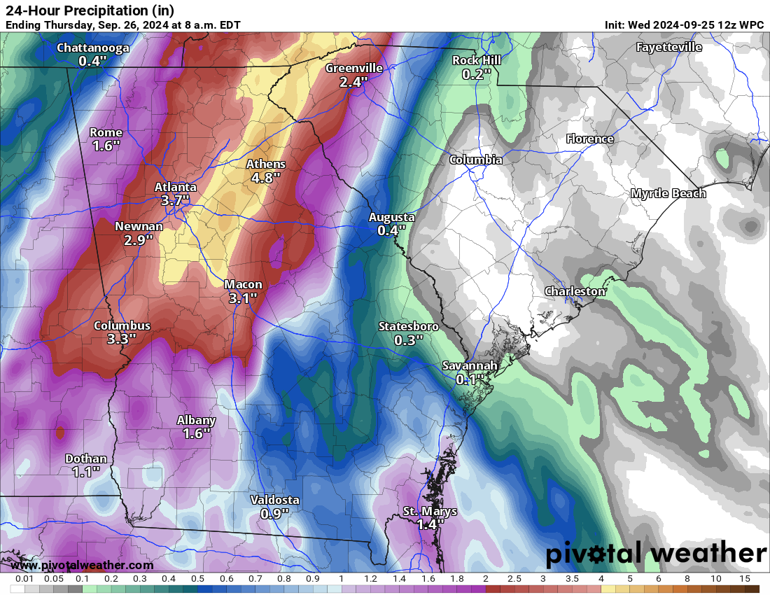
With more rain tomorrow and the storm itself not arriving until tomorrow night and Friday, conditions will steadily deteriorate into Friday in those areas, and the severity of flash flooding will worsen. This will be a prolonged, extremely serious flooding event for North Georgia, Upstate South Carolina, and western North Carolina. Landslides, at least moderate river flooding, and possibly major river flooding is a safe bet in those areas. Current forecasts indicate perhaps as much as 20 inches of rain in some southeast facing mountains in western North Carolina.
We will update again later today.
What’s changed since yesterday
- Helene’s forecast intensity as it approaches Florida has been increased a bit, with risk for further increase in the intensity forecast today. Folks between Port St. Joe and Cedar Key should be preparing for major hurricane impacts.
- Hurricane Warnings extend into Georgia, a good bit beyond Valdosta. Tropical Storm Warnings now cover virtually the entire Florida Peninsula. Tropical Storm Watches extend into central Georgia and much of southeastern South Carolina.
- Helene’s track and surge forecast is relatively unchanged.
- The interior rainfall forecast has escalated, and there is growing risk of a potentially damaging, catastrophic flash flooding event from northeast Georgia into western North Carolina, including Asheville.
Not a whole lot has changed since yesterday. It’s nice to have a consistent forecast, but this is certainly turning into quite a serious situation for the eastern Florida Panhandle and Big Bend. Again, the minimum you should expect right now is an Idalia-type impact. For many, if not most places between Apalachee Bay and Tampa, this will probably be a worse impact than Idalia. Current surge forecasts continue to suggest impacts at or above Idalia. This surge forecast is virtually unchanged from 12 hours ago.
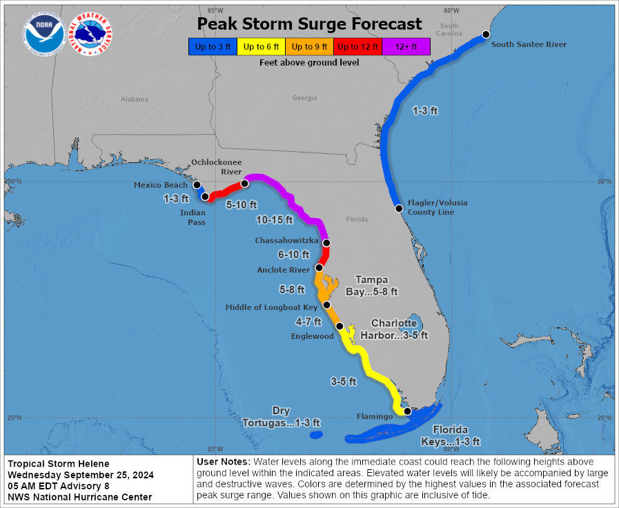
There’s honestly not a whole lot that needs to be said here with respect to the Florida coast between Cedar Key and Apalachee Bay: This has a decent chance to be worse than Idalia was and you should be closely following the advice of local officials.
The track forecast isn’t entirely locked down, but it’s close to it right now. There are still a handful of model data points suggesting a track slightly farther east than currently shown by the majority of tropical models and the official NHC forecast. This won’t hit Tampa directly, but a track closer to Cedar Key or Steinhatchee is possible, a Nature Coast/Big Bend hit more than an Apalachee Bay hit. This is why we encourage everyone from Port St. Joe to Homosassa or Clearwater to prepare for a significant hurricane hit, be it via surge, wind, or both.
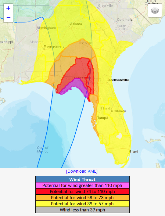
It’s also important to note how deep into Georgia hurricane-force winds are expected to go. That takes them close to Albany, GA and about halfway to Macon. Tropical storm force winds are expected to extend north of Macon to metro Atlanta and into South Carolina. This will almost certainly cause widespread power outages, and folks should be prepared to be without power for at least a few days.
Here is a list of major cities and their maximum wind gust forecasts from the NWS Point and Click forecasts as of Wednesday morning. These are likely to change:
(Editor’s Note: We will update these later today with slightly better data than point & click forecasts)
Florida
Tallahassee: 63 mph
Cedar Key: 80 mph
Apalachicola: 77 mph
Panama City: 54 mph
Clearwater: 60 mph
Tampa: 59 mph
Sarasota: 72 mph
Fort Myers: 57 mph
Naples: 56 mph
Orlando: 49 mph
Jacksonville: 63 mph
Gainesville: 56 mph
Key West: 44 mph
Elsewhere
Valdosta: 57 mph
Albany, GA: 68 mph
Macon: 92 mph
Atlanta: 56 mph
Savannah: 39 mph
Athens: 75 mph
Augusta: 46 mph
Charleston: 37 mph
Columbia: 41 mph
Greenville: 48 mph
Spartanburg: 43 mph
Charlotte: 41 mph
Asheville: 51 mph
A major, potentially catastrophic flooding event possible in the Appalachians
I want to focus on one element of this storm that is now coming into focus and becoming very serious: The risk of significant, possibly catastrophic flash flooding in the Appalachians from north Georgia into North Carolina.
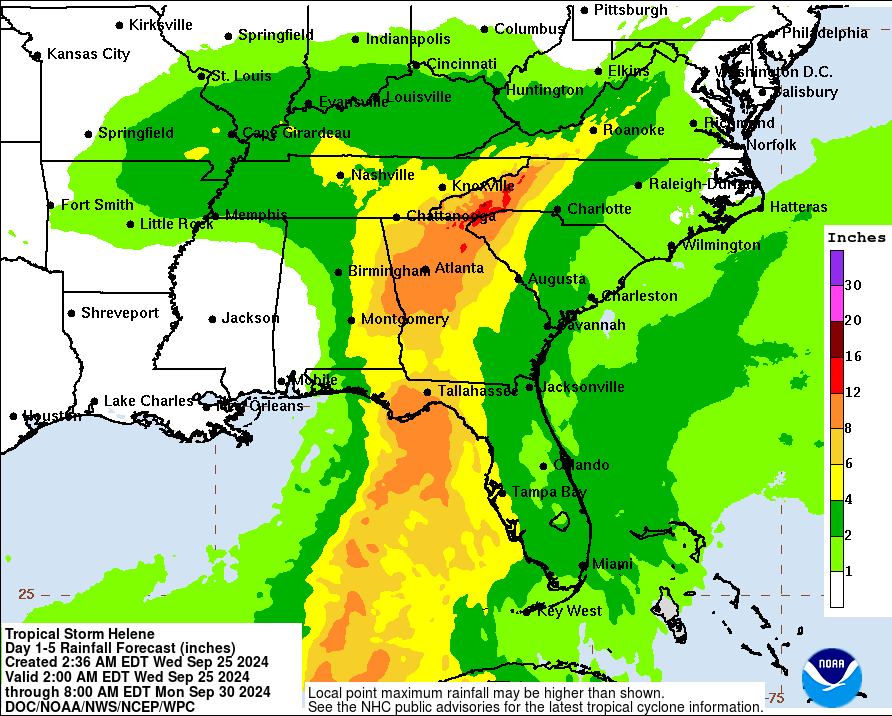
A high risk of flooding has been issued for some of those areas by the Weather Prediction Center, which historically has correlated to extensive, significant damage.
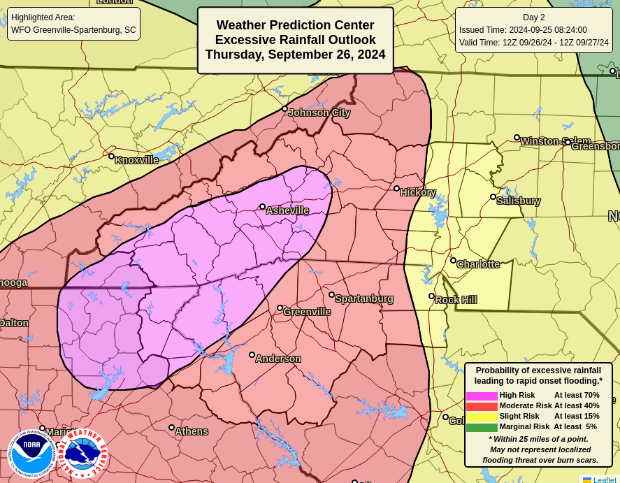
This is a historically favorable setup for major rainfall in this region, and there’s no reason to believe this forecast is incorrect. So for anyone in those affected areas and even in the red moderate risk areas surrounding the high risk, it is important to be prepared to take immediate action in the case of flooding or landslides. Please heed the advice of local officials. It is possible that the damage and problems from the inland flooding will be equally as bad as the surge issues at the coast.
Helene is going to be a complex, very difficult storm with multiple different concerns along the way. We’ll keep you posted as best we can through the event, but please also stick with trusted local sources for the latest and most relevant information for your neighborhood. We’ll update this post through the day.
Maybe it’s just my imagination but it seems like all the models you reference regularly came into agreement on the development and path of this storm system relatively early vs. other storm systems this summer. Is there something in particular about location/current conditions that supported that? (i.e. some onshore conditions being very stable, or a lot of history of storms forming there and taking that path for the models to be influenced by). Or am I just remembering the development of earlier systems differently?
To me prediction of storm path is firm at 48 hours, for avg storm this means 2/3rd of way to Yucatan from Houston. This storm heading to Florida to hit Thursday PM was well predicted by Tuesday PM, but you’re right even Monday PM they had the path well predicted. So good job to them, 72 hour prediction basically down to 100 mile wide corridor. The corridor at 72 hours was 100 miles Tampa metro to 100 miles west…. Or put another way, at 72 hours they predicted path down to 15 degrees on the compass, excluding the other 345 degrees, so 4.166% cone of danger and 95.8% rest could relax. So at 3 or certainly 2 days if you’re in the cone, you’re unlucky and should react at 2. Or I could be wrong…..
Yeah this one is actually going to be an interesting case study, not just because modeling was in pretty good agreement on track and hinted at intensity risks early on, but because the *downstream* pattern for the storm really kind of underwent a lot of change in the last week or so. The forecasts shifted with the upper low over the Mid-South, and some other features maneuvering around, yet the consistency with Helene was remarkable. You are correct about this one being pretty good versus the others this year. Though even Francine was a pretty solid forecast earlier this month.
Sometime maybe you’ll explain how the dynamics of the Upper Low over the MidSouth played out in the forecast. Thanks.
How different is the path through the Appalachian mountains is this storm compared to hurricane Agnes.
A bit farther to the west and not nearly as far north. It kind of slows and stalls out over the Tennessee Valley rather than continuing north into PA and NY like Agnes did.
Did the Cane go between Cuba and Yucatan by accident, or get steered by factors to stay over water? Do storms similarly stay parallel to FL a while by such steering till finally hit mainland?? So storms try to wiggle around and brush by as much land and islands as reasonably possible till they hit hard and die? ??
Storms, particularly as early in their life cycle as Helene usually won’t be too bothered by land…other factors steering them will dictate if they come ashore or miss offshore. Once you get bigger storms, sometimes land or terrain features can help deflect the storm, though in Florida, that’s less likely given how little terrain there is.
It seems this storm took a long time forming. For days and days we have watched the map and there was little to no movement out of the far western Caribbean. Now, suddenly, it will move at breakneck speed across the Gulf of Mexico and cause havoc in northwestern Florida. I suppose that’s partially good news. The longer it stays over warm water, the greater the intensity, right? Is there some atmospheric system that is pulling the storm toward the north-northeast?
Yes the intensity will increase due to warm ocean water. its moving north due to being caught by a trough (area of low pressure)
And I’m worried about a tropical system I see coming in at about a week behind Helene, same general area…On GFS, and CMC, today, early morning when I looked..
I’ve seen similar all week, on the various tropical tidbit models..If this comes to pass, there may be a lot of people who will have no clue, due to lack of internet, cell service, electricity..I would not want to experience two tropical systems back on back..
Even if the system turns out to be only a rainmaker, there is the good and bad IMO..
Keeps impacted area cooler while power is out..
Unfortunately it postpones or complicates cleanup and repairs for several more days…
I am praying hard that I am wrong in what I saw, and that nothing else hits the Helene impacted area..
I saw that too – around Oct 5th.
One thing at a time. Let’s worry about what is known to be fact at this time.
It’s a Hurricane now. And predicted to be a Category 3 by landfall.
Craig: The prediction now is for a Cat 4 by landfall.
I’m in Knoxville and I’ve now heard the term “predecessor rain event” twice today. Never heard this term before. Is it something specific or just literally rain before a tropical storm?
I’m curious about the term as well. Houston had some pretty intense storms pop up a couple days ahead of Beryl that Eric described as not being directly related to Beryl. Was that a predecessor rain event?