Headlines
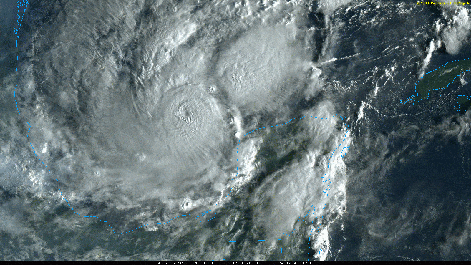
- Milton exploded into a category 5 hurricane today, small but incredibly powerful.
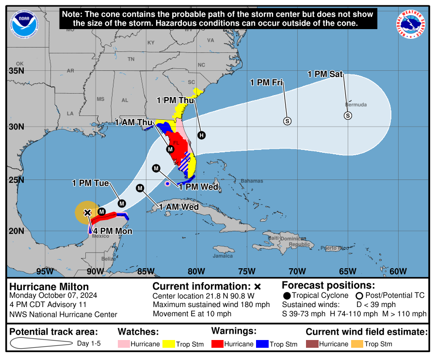
- Milton’s intensity is expected to fluctuate over the next couple days as it grows in size, but it will almost certainly hit Florida as a powerful hurricane with major surge.
- It is now expected to bring a 10 to 15 foot surge to Tampa Bay, far worse than Helene and beyond anything observed there in modern times.
- Significant storm surge south of Tampa Bay as well, including for Sarasota, Punta Gorda, Fort Myers, and perhaps Naples.
- If told to evacuate, please heed the advice of local officials and if you know someone unable to evacuate or that is stubborn, please try every means of convincing them and/or assisting them to do so.
- Hurricane conditions likely inland as well (Orlando, Ocala, etc.), but shelter-in-place is recommended, along with planning for possible extended power outages.
- East coast surge will be worse than Helene but still generally minor to moderate. Heed the advice of local officials there.
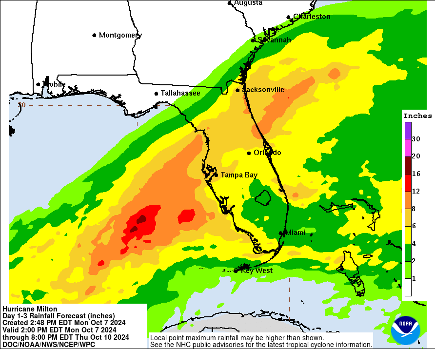
- 6 to 12 inches of rain across Florida north of I-4 expected with widespread river and flash flooding.
- A 4 to 6 foot surge is expected on the north coast of the Yucatan near Merida and Progreso tonight as Milton passes.
We all know storms can intensify faster than forecast. We’ve seen enough examples in the last 6 or 7 years to count on two hands. But it’s never not shocking when you see it. When I wrote this morning’s post, Milton had just become a category 3 major hurricane with 120 mph winds. By the time everyone finished lunch, it was a 175 mph category 5 storm. Unhinged intensification is what happens when you combine a tropical system in a near-perfect environment over extremely warm and warmer than usual water.
I won’t bury the lede: If you’re asked to evacuate in Florida, please do. If you know of anyone unable to or that is unwilling to, try to reason with them or help them where possible. We are not here to tell you what to do, so much as provide information, but I want to be very clear that if I were ordered to evacuate from this storm, I would not think twice. Again, you needn’t go hundreds of miles away. You can hide from wind inland. You need to be away from the surge though. What you saw during Helene was more of an appetizer of what could occur with Milton, namely from the Tampa Bay area southward.
This evening, Milton is still a category 5 hurricane with 180 mph maximum sustained winds. There is some chance that Milton could strengthen further, but we’re kind of closing in on theoretical maximum intensity here, and usually category 5 hurricanes don’t stay at peak intensity for more than 12-18 hours or so.
Here’s the rub. Let’s say Milton undergoes an eyewall replacement cycle (ERC). I won’t get into the weeds, but that’s essentially where a hurricane sort of internally pauses, takes a breath, and resets itself. When it does this, it usually comes back larger in size but a bit weaker in intensity. Right now, tropical storm force winds extend out only 80 miles from the center. Compare this to the over 300 miles Helene’s winds were from the center. Hurricane-force winds extend out 30 miles, and those 180 mph winds? They’re in an extremely small pocket in the eyewall. So let’s say Milton undergoes an ERC tonight. Tomorrow, it may be a high-end cat 4 or still a cat 5, but it will be larger in size. A larger storm can move more water. Let’s say it happens again. Milton maybe becomes a cat 3 or lower-end cat 4, but now it’s doubled in size from today. That means that while the winds won’t be as extreme, they’ll cover a wider area. And the surge? Well, it will punch above its weight class and even if Milton is a 2 or a 3 at landfall, this massive storm surge we’ve been screaming about will still come to fruition, akin to more like a category 4 storm.
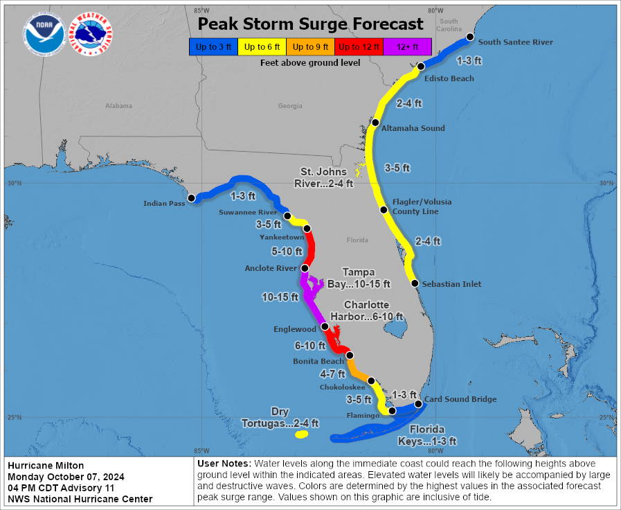
So with that, storm surge forecasts have been fine tuned a bit this evening, and frankly they aren’t great. The surge is now expected to be as high as 10 to 15 feet in Tampa Bay. The only way Tampa avoids that now is if the storm track shifts south of the bay entrance. In that case, surge would drop off a good bit and the bay would empty, much as it did during Irma and Ian. Damaging but not catastrophic. As forecast right now, this would be an extremely damaging to potentially catastrophic scenario for Tampa Bay. Worse than Helene by a mile. Again, please heed local government advice and evacuate if told to.
Surge will also be damaging down the coast. Sarasota, Punta Gorda, Fort Myers, and perhaps Naples will all see significant storm surge. Those areas have a bit less uncertainty in the surge forecast compared to Tampa Bay, as the storm will almost certainly stay to the north, bringing significant surge ashore there.
Notably, the Yucatan should not be left out in all this. Though Milton’s strongest winds will pass well offshore, anywhere exposed to onshore winds may see a 4 to 6 foot increase in water level tonight as Milton passes, leading to coastal flooding near Merida and Progreso and just east of there.
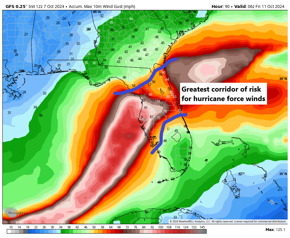
For inland areas, this will be a bad storm as well. Expect numerous widespread power outages. Hurricane warnings are posted inland to include Orlando and Ocala. Various watches and warnings are in effect elsewhere across Florida, including now on the east coast of Florida with a hurricane watch from St. Lucie County to the Georgia border/St. Mary’s River. Winds will likely gust to hurricane force with some sustained hurricane force winds possible too. For those of you on the east coast, note the surge map above as well. Milton will cause higher surge than Helene did on the east coast. Hurricane force winds are possible on the east coast too. Unless you’re told to evacuate, sheltering in place is the best advice for folks in inland areas and between the First Coast and Space Coast.
Rainfall of 6 to 12 inches will be possible along and north of where Milton tracks. Flash flooding and riverine flooding is possible, if not likely in these areas.
Some keen eyed observers noted the yellow X on the NHC map as well. That is separate from Milton and does not matter, as it is moving out to sea. The only tropical concern anyone should have right now is Milton. And we will leave it there. Our next update will come tomorrow morning.
This reminds me of when Ike hit the Bolivar Penninsula and Galveston as a Cat 2 after having been a Cat 4 in the Gulf. It pushed Cat 4 level storm surge over Galveston and Bolivar, wiping Bolivar clean. It was nightmarish. Praying for Floridians and hoping they heed the evacuation orders.
Ike was only a cat 2 in the gulf; it had such a bad surge because the wind field was so enormous.
It doesn’t need to be said, but I will anyway: This is a major catastrophe in the waiting for Floridians, I do hope they all heed the warnings and move north fast. Houses can be rebuilt, but lives once lost are lost forever.
Well reported. Easy to understand. Makes all the difference!! Thank you!!
I can attest that after sharing your site, it convinced colleagues in NE Orange Co to prepare more than they originally considered. “Thank you. We got the last water at Walmart”. That was Saturday.
Today, after reading your update, as retired medical professionals, they started calling upon their elderly neighbors and moved essentials, meds, etc, over to their place. Their neighbors will come there tomorrow night and bunk in until it is safe to return home.
The work you guys do..it matters alot.
It is going to matter for (at least) these 10 people. Given the circumstances, they will be as safe as anyone can be and they won’t be alone.
Thank you.
Thank you for sharing this. ❤️
Wonderful to hear. All the best to them!
Whoa!! I just went to the NHC website (it was broken earlier) to check on status …
Now there’s a yellow X on the southeastern coast of FL. So, it’s a 20% for 2 days and 20% over 7 days … fortunately, they state it’s supposed to move northeastward into the southwestern Atlantic by tomorrow.
Also watching Fox 24 Hr Weather channel – they are showing I-75 jam-packed with traffic. It’s red and yellow from Tampa north to Gainesville. It is good folks are heading out!!
I’m in Lakeland Fl, I’m worried about the wind here. What’s the estimate for wind/gusts here?
Cancelled our trip to Orlando for this weekend–and if you’re reading this because you also have a trip planned: I urge you to cancel as well! No need to be adding additional strain to Florida!
I see another storm ( as per the 1800z on the GFS ) heading for Florida near the end of this month..
I am praying hard that this is an extreme model outlier that doesn’t come to fruition even as a tropical depression.. I didn’t really want to mention or ask about it, when all eyes are on Milton, but Jeeze, what are the forces that keep churning out these storms one after another that then strengthen into monsters?
I’m terrified that there won’t be any gulf states left inhabitable within the decade, if our late hurricane seasons begin to look like this every year..With monster storms churning out at this rate, that stay strong inland, there may be no safe place to live, even hundreds of miles away from the beaches…
My heart is broken for Florida and the other places impacted by Helene, and about to be impacted by Milton..
I heard from a friend in Sarasota that the highways are jammed and the gas stations are empty anyway. So I guess the best some people can do is get away from the surge. I suppose the time to evacuate was yesterday.
Allow me to correct myself–my friend just texted me and said this evening traffic is moving well on I-75 and also that gas stations are being refilled. She is leaving, heading north.
This is bringing back memories of Hurricane Rita — not one that’s often mentioned, but it was the next major storm that came after Katrina in 2005. I was starting graduate school at Rice in Houston and still didn’t know a lot about hurricanes and got caught up in the insane gridlock (12 hours driving to go a few tens of miles!!). We eventually turned around, and Rita’s path shifted away from Houston. But that feeling like you don’t know if your house will collapse around you if you try to ride it out… it’s terrifying. Thinking of all you florida folks.
Yes!!! Rita may not be discussed as broadly, but for those of us who were stuck in that evacuation…
Praying for the people of Florida and for the first responders on the ground and waiting to enter. For all of them: protection, wisdom, common sense, patience, fortitude, and an extraordinary peace amidst the storm. For neighbors helping neighbors, on every scale.
Grateful for the tools and skills of weather forecasting in general and especially The Eyewall and Space City Weather. Storms will always come, but humanity is able to prepare. Galveston 1900, no more.
Hugs and prayer from Houston