In brief: Hurricane Erin will continue to impact the Turks and Caicos and southeast Bahamas today. It remains on course to head out to sea, but it’s likely to cause significant impacts in the Outer Banks and widespread coastal flooding, beach erosion, and rip currents along the East Coast. Meanwhile, the next wave behind Erin is too early on to worry about, though it will be worth watching this week.
Can I just interject for a minute before we get into today’s post? I must be a glutton for punishment, as my “new tabs” in Microsoft Edge show up with completely absurd news headlines. Though this time of year, it becomes more entertainment than anything. For example, according to the Irish Star:
Let’s simply ignore the fact that the storms that will “batter Florida” are of the typical summertime variety, completely unrelated to Erin. Much to everyone’s relief, I did read the article, and I still don’t know what the “the worst” is that the experts fear. European tabloids are a contact sport, so I’d expect nothing less, but anyway, it’s little things like this that justify The Eyewall’s existence.
Hurricane Erin
Alright, onto the serious matter at hand, which is Hurricane Erin.
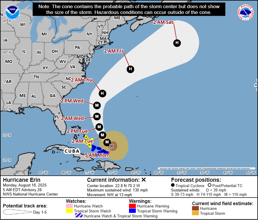
Erin is back up to category 4 intensity this morning, with maximum sustained winds of 130 mph. It sits just north of the Turks and Caicos Islands. Erin has continued to grow in size since yesterday. The tropical storm-force wind field extends out 230 miles now. Hurricane-force winds have more than doubled in size, now extending out 80 miles from the center. This places Erin in the 80th percentile of major hurricanes in terms of size. In plain language: Bigger than usual.
Erin remains a very formidable and growing hurricane. Tropical storm conditions will continue today in the southeast Bahamas and Turks and Caicos Islands, where Tropical Storm Warnings remain posted. A Tropical Storm Watch is now posted in the Central Bahamas.

Erin is likely beginning another period of intensification this morning that may continue into this evening. After that, Erin will likely begin to feel some impacts of wind shear in the area that will slowly erode at its intensity. Erin should remain a category 3 or stronger hurricane through Wednesday, however.
For the southeastern Bahamas, Turks and Caicos, and Hispaniola, squally weather will continue today and tonight. By tomorrow, Erin should finally begin to move away, allowing conditions to improve some.
Beyond the Bahamas, Erin’s track forecast has continued to nudge slightly westward, though not as much as it had this weekend. Erin will remain off the Southeast coast and split the difference between the Outer Banks and Bermuda on its way off to the north and eventually northeast.
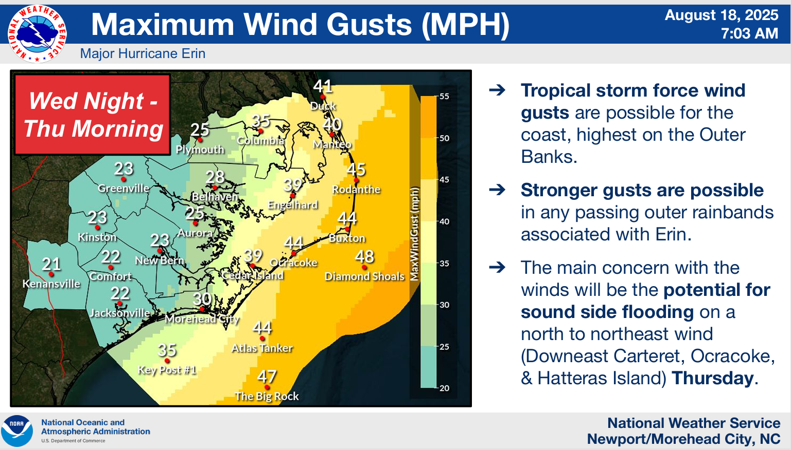
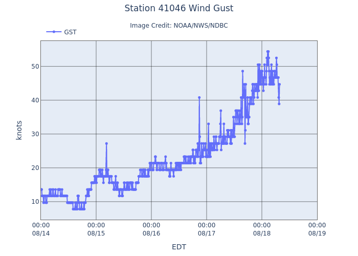
As Erin passes the Outer Banks, tropical storm-force wind gusts will be likely, perhaps approaching 50 mph just offshore. While those wind gusts will be a bit of a nuisance, they aren’t anything too terrible for this area. However, the waves and rip currents will be a big problem. Based on the latest forecasts, this will be a prolonged event for the area with several days of difficult, if not impossible travel along NC-12 for Hatteras and Ocracoke Islands. Heed the advice of local officials in these areas.
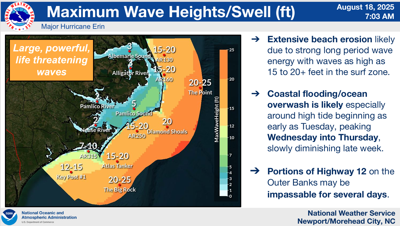
Conditions should be at their worst late tomorrow into early Thursday before slowly easing up. Rip currents and rough surf will be a developing issue up and down the entire East Coast this week. Rip current statements are in place from West Palm Beach northward already. Basically, swimming won’t be advisable, as even the strongest and best swimmers can’t always overcome strong rip currents.
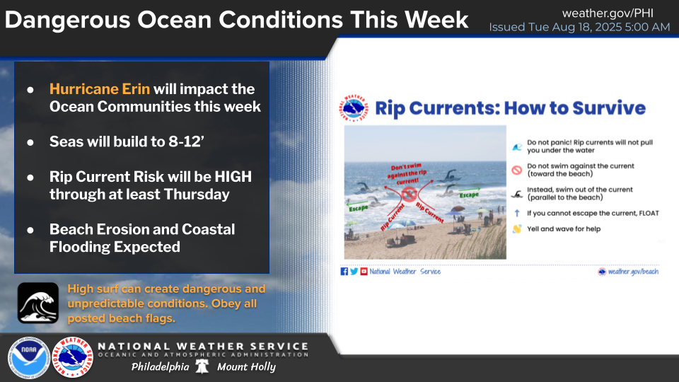
Tidal flooding will also be an issue up and down the East Coast, with coastal flood advisories or statements posted as far north as Long Island.
Bottom line: Hurricane Erin will directly impact the Turks and Caicos Islands and Southeast Bahamas today. As Erin passes offshore, rip currents, rough surf, beach erosion, and tidal flooding will be a concern from as far south as Florida into the Carolinas into New England.
Eventually, some of these wave issues will make it to Atlantic Canada as well toward the weekend.
Next wave up
The next tropical disturbance is a nascent wave west of the Cabo Verde Islands.
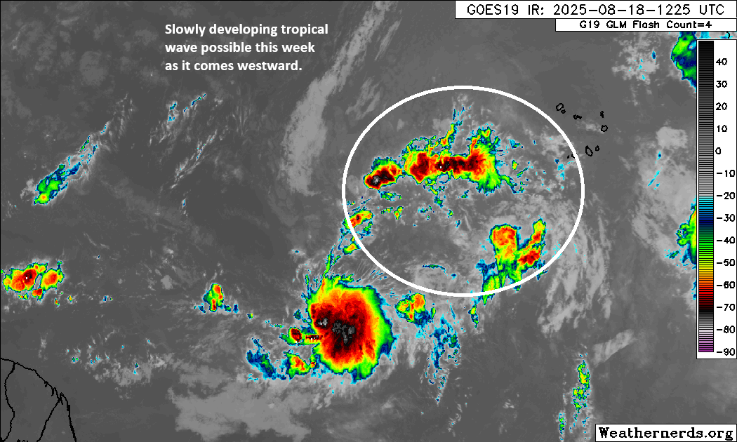
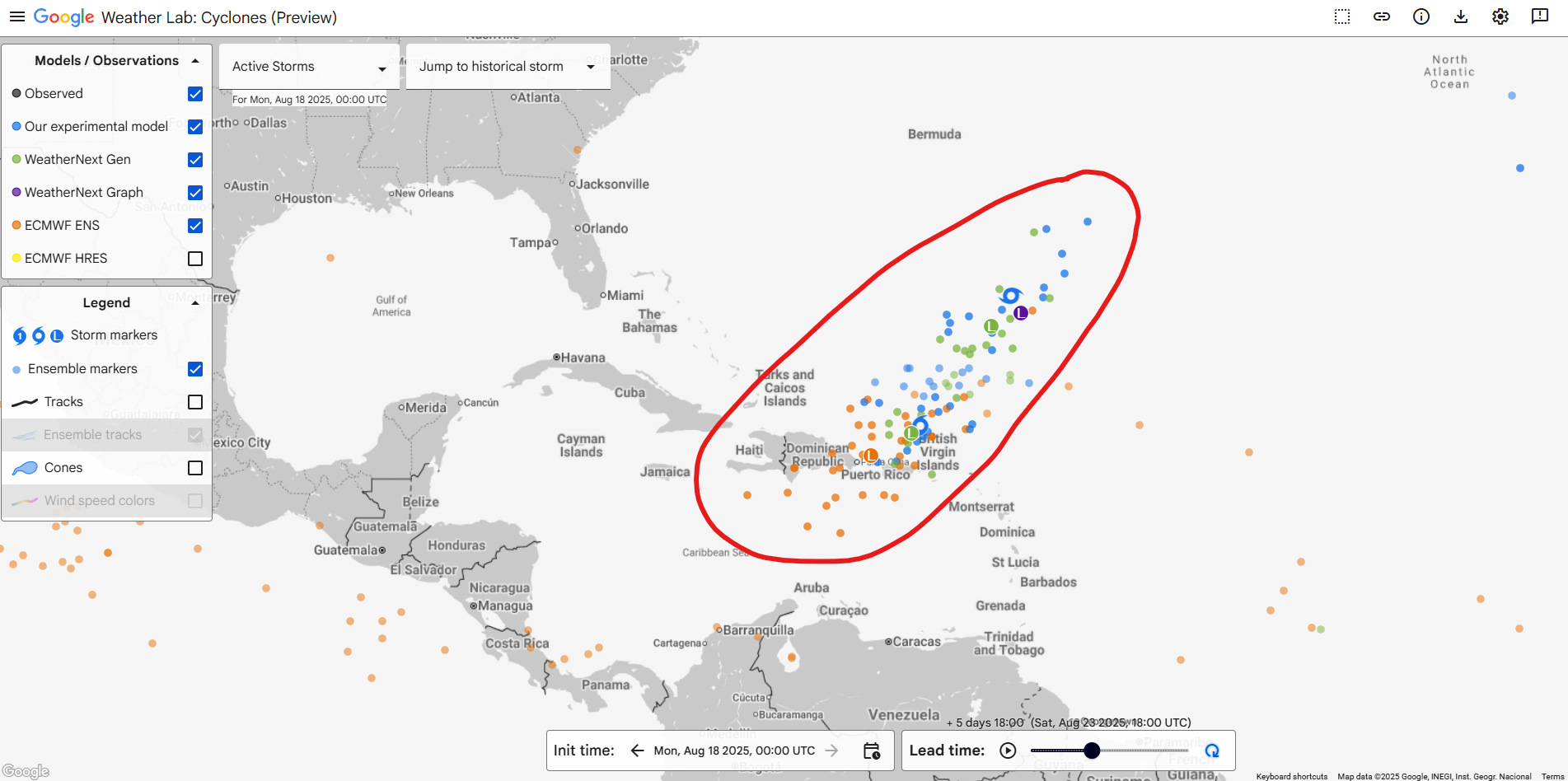
We have a ways to go here with this one, but I suspect we have an invest area out of this wave by tomorrow. The math on this is pretty simple, but deriving the equation is still very challenging. We know that a weaker tropical wave would probably continue west or west-northwest toward the Caribbean. Basically, if this doesn’t do much in the way of developing, it will probably continue to sneak westward. Alternatively, if it develops quickly as it comes across, or at the speed of Erin’s early organization, it would probably turn northwest and north and follow Erin out to sea. By the time we get to the weekend, we will see if this thing is farther south, closer to the islands, or more out into the open Atlantic, as most AI modeling seems to favor.
We have a long way to go with this one, but it’s not currently worth worrying about. Just check in daily for updates. We’ll keep you posted.